View
Add
Copy
Edit
Delete
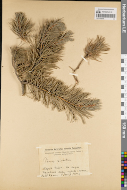
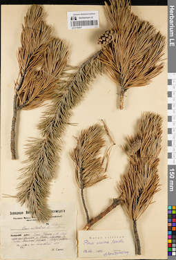
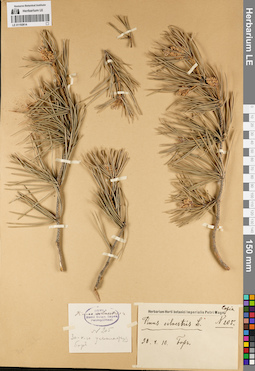
LE 01192619
Pinus sylvestris L. det. Busch
Collectors: Krol, Moissei Aaronovitch Collection date: 09.07.1911. Administrative regions: RU - Zabaykal'skiy Kray - Chitinskiy Rayon. Place of collection: г. Чита, на горе, сосняк.Expedition: Ботанические коллекции Общества изучения Сибири и улучшения её быта (1911)Groups of specimens: Образцы сектора Сибири и Дальнего Востока России; Соглашение Минобрнауки №075-15-2021-1056Original label text:Herbarium Horti botan. Imperialis Petropolitani. Ботанические коллекции Общества изучения Сибири и улучшения ее быта 1911 г. Pinus silvestris. Город Чита. На горе. Преоблад. лесн. порода: сосна. Собр. Кроль. 9 июля 1911 г
Landscape in location of collection: склон горыHabitat / plant community in location of collecting: соснякCoordinates (geographic position): 52° 2′ 1.09″ N, 113° 30′ 3.78″ E ±30000 mRecord creation: 2022-07-28, Larisa Orlova, PhotoScan D2. Part 3.Citation: Specimen LE 01192619 // Virtual herbarium of Komarov Botanical Institute RAS — http://re.herbariumle.ru/01192619
LE 01192409
Groups of specimens: Образцы общего сектораRecord creation: 2022-07-28, Larisa Orlova, PhotoScan D2. Part 1.Citation: Specimen LE 01192409 // Virtual herbarium of Komarov Botanical Institute RAS — http://re.herbariumle.ru/01192409
LE 01192407
Groups of specimens: Образцы общего сектораRecord creation: 2022-07-28, Larisa Orlova, PhotoScan D2. Part 1.Citation: Specimen LE 01192407 // Virtual herbarium of Komarov Botanical Institute RAS — http://re.herbariumle.ru/01192407

LE 01192408
Groups of specimens: Образцы общего сектораRecord creation: 2022-07-28, Larisa Orlova, PhotoScan D2. Part 1.Citation: Specimen LE 01192408 // Virtual herbarium of Komarov Botanical Institute RAS — http://re.herbariumle.ru/01192408
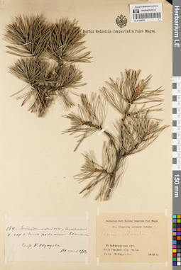
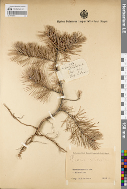
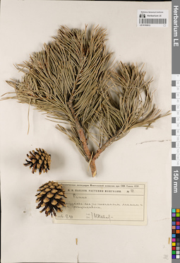
LE 01192618
Pinus sylvestris L. det. Busch
Collectors: Okuntsova, K. Field collecting number: 249. Collection date: 15.06.1912. Administrative regions: RU - Zabaykal'skiy Kray - Chitinskiy Rayon. Place of collection: окрестности г. Чита.Groups of specimens: Образцы сектора Сибири и Дальнего Востока России; Соглашение Минобрнауки №075-15-2021-1056; От Общества изучения СибириObject features: обильноOriginal label text:[1]249. Забайкальская обл., Читинский у., окр. г. Читы. Почва песчан. Обильно. Собр. К. Окунцова. 15 июня 1912 г. [2] Herbarium Horti Botanici Imperialis Petri Magni. От Общества изучения Сибири. Pinus silvestris L. Забайкальская обл. Окрестности гор. Читы. Собр. К. Окунцова. 1912 г
Coordinates (geographic position): 52° 2′ 1.09″ N, 113° 30′ 3.78″ E ±30000 mRecord creation: 2022-07-28, Larisa Orlova, PhotoScan D2. Part 3.Citation: Specimen LE 01192618 // Virtual herbarium of Komarov Botanical Institute RAS — http://re.herbariumle.ru/01192618
LE 01192406
Groups of specimens: Образцы общего сектораRecord creation: 2022-07-28, Larisa Orlova, PhotoScan D2. Part 1.Citation: Specimen LE 01192406 // Virtual herbarium of Komarov Botanical Institute RAS — http://re.herbariumle.ru/01192406
LE 01192405
Groups of specimens: Образцы общего сектораRecord creation: 2022-07-28, Larisa Orlova, PhotoScan D2. Part 1.Citation: Specimen LE 01192405 // Virtual herbarium of Komarov Botanical Institute RAS — http://re.herbariumle.ru/01192405
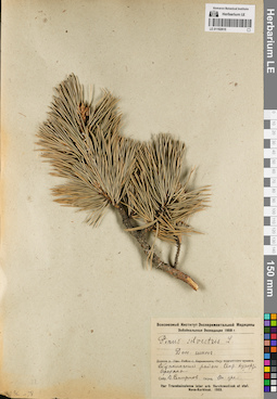
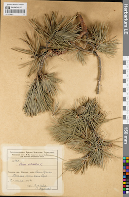
LE 01192617
Pinus sylvestris L. det. Savich, N. at 1932
Additional identifications: Pinus ursina Kondr. det. Kondratjuk, Evgeniĭ Nikolaevich at 28.02.1952 Collectors: Savich, N. Field collecting number: 757. Collection date: 11.07.1932. Administrative regions: RU - Respublika Sakha (Yakutiya). Subregion: Нерюнгринский улус. Place of collection: хр. Удокан (Южно-Муйского хр.), долина р. Новен (приток р. Чара), песчаная терраса, лиственнично-сосновый лес.Expedition: Экспедиция Восточно-Сибирск. Госземтреста (1932)Groups of specimens: Образцы сектора Сибири и Дальнего Востока России; Соглашение Минобрнауки №075-15-2021-1056Original label text:Экспедиция Восточно-Сибирск. Госземтреста. Растения Витимо-Олекминского (Эвенкийского) национального округа. № 757. Pinus silvestris L. Каларский район. Горы Удокан (Ю.-Муйского хр.). Долина р. Новен, притока р. Чары. Песчаная терраса. Лиственнично-сосновый лес. 11.VII.32 г. Н. Савич
Landscape in location of collection: песчаная терраса рекиHabitat / plant community in location of collecting: лиственнично-сосновый лесCoordinates (geographic position): 57° 5′ 19.32″ N, 119° 48′ 20.88″ E ±50000 mRecord creation: 2022-07-28, Larisa Orlova, PhotoScan D2. Part 3.Citation: Specimen LE 01192617 // Virtual herbarium of Komarov Botanical Institute RAS — http://re.herbariumle.ru/01192617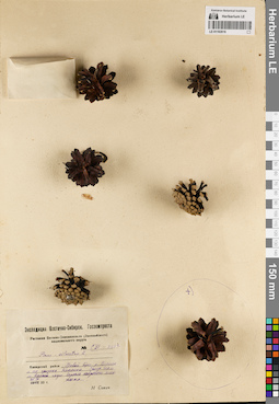
LE 01192616
Pinus sylvestris L. det. Savich, N. at 1932
Collectors: Savich, N. Field collecting number: CLI-1105а. Collection date: 25.09.1932. Administrative regions: RU - Irkutskaya Oblast' - Bodaybinskiy Rayon. Place of collection: правый берег р. Витим и его притока р. Амалык (Эмалык), склон горы, ее верхней части, заросль кедрового сланника.Expedition: Экспедиция Восточно-Сибирск. Госземтреста (1932)Groups of specimens: Образцы сектора Сибири и Дальнего Востока России; Соглашение Минобрнауки №075-15-2021-1056Original label text:Экспедиция Восточно_Сибирск. Госземтреста. Растения Витимо-Олекминского (Эвенкийского) национального округа. № CLI-1105а. Pinus silvestris L. Каларский район. Правый берег р. Витима и его притока Эмалыка. Склон горы, ее верхней части. Заросль кедрового сланника. 25.IX.32 г. Н. Савич
Landscape in location of collection: склон горы в ее верхней частиHabitat / plant community in location of collecting: заросль кедрового стланикаCoordinates (geographic position): 57° 29′ 57.79″ N, 116° 36′ 34.11″ E ±10000 mRecord creation: 2022-07-28, Larisa Orlova, PhotoScan D2. Part 3.Citation: Specimen LE 01192616 // Virtual herbarium of Komarov Botanical Institute RAS — http://re.herbariumle.ru/01192616
LE 01192402
Groups of specimens: Образцы общего сектораRecord creation: 2022-07-28, Larisa Orlova, PhotoScan D2. Part 1.Citation: Specimen LE 01192402 // Virtual herbarium of Komarov Botanical Institute RAS — http://re.herbariumle.ru/01192402

LE 01192403
Groups of specimens: Образцы общего сектораRecord creation: 2022-07-28, Larisa Orlova, PhotoScan D2. Part 1.Citation: Specimen LE 01192403 // Virtual herbarium of Komarov Botanical Institute RAS — http://re.herbariumle.ru/01192403
LE 01192404
Groups of specimens: Образцы общего сектораRecord creation: 2022-07-28, Larisa Orlova, PhotoScan D2. Part 1.Citation: Specimen LE 01192404 // Virtual herbarium of Komarov Botanical Institute RAS — http://re.herbariumle.ru/01192404
LE 01192615
Pinus sylvestris L. det. Smirnov, V. at 1933
Collectors: Smirnow, Valentin Ivanovich Collection date: 1933. Administrative regions: RU - Respublika Buryatiya - Tunkinskiy Rayon. Place of collection: пос. Аршан, окрестности курорта Аршан.Expedition: Забайкальская экспедиция 1933 г. (1933)Groups of specimens: Образцы сектора Сибири и Дальнего Востока России; Соглашение Минобрнауки №075-15-2021-1056; Всесоюзный институт экспериментальной медициныOriginal label text:Всесоюзный Институт Экспериментальной Медицины. Забайкальская Экспедиция 1933 г. Pinus silvestris L. Дин. шинг. Тункинский район. Окр. курорта Аршана. Собр. В. Смирнов. Опред. Он же. iter Transbaicalense inter urb. Verchneudinsk et stat. Novo-Kurbinsk. 1933
Coordinates (geographic position): 51° 55′ 2.4″ N, 102° 25′ 59.53″ E ±2000 mRecord creation: 2022-07-28, Larisa Orlova, PhotoScan D2. Part 3.Citation: Specimen LE 01192615 // Virtual herbarium of Komarov Botanical Institute RAS — http://re.herbariumle.ru/01192615
LE 01192399
Groups of specimens: Образцы общего сектораRecord creation: 2022-07-28, Larisa Orlova, PhotoScan D2. Part 1.Citation: Specimen LE 01192399 // Virtual herbarium of Komarov Botanical Institute RAS — http://re.herbariumle.ru/01192399

LE 01192398
Groups of specimens: Образцы общего сектораRecord creation: 2022-07-28, Larisa Orlova, PhotoScan D2. Part 1.Citation: Specimen LE 01192398 // Virtual herbarium of Komarov Botanical Institute RAS — http://re.herbariumle.ru/01192398

LE 01192400
Groups of specimens: Образцы общего сектораRecord creation: 2022-07-28, Larisa Orlova, PhotoScan D2. Part 1.Citation: Specimen LE 01192400 // Virtual herbarium of Komarov Botanical Institute RAS — http://re.herbariumle.ru/01192400
LE 01192614
Groups of specimens: Образцы сектора Сибири и Дальнего Востока России; Соглашение Минобрнауки №075-15-2021-1056Record creation: 2022-07-28, Larisa Orlova, PhotoScan D2. Part 3.Citation: Specimen LE 01192614 // Virtual herbarium of Komarov Botanical Institute RAS — http://re.herbariumle.ru/01192614
LE 01192401
Groups of specimens: Образцы общего сектораRecord creation: 2022-07-28, Larisa Orlova, PhotoScan D2. Part 1.Citation: Specimen LE 01192401 // Virtual herbarium of Komarov Botanical Institute RAS — http://re.herbariumle.ru/01192401
LE 01192613
Pinus sylvestris L. det. Busch
Collectors: Rybak, E.L. Field collecting number: 6. Collection date: 10.06.1912. Administrative regions: RU - Zabaykal'skiy Kray - Chitinskiy Rayon. Place of collection: с. Маккавеево.Groups of specimens: Образцы сектора Сибири и Дальнего Востока России; Соглашение Минобрнауки №075-15-2021-1056Original label text:[1]N 6. 10 Июня, 1912. Макавеево Заб. обл. Собр. Е. Рыбак [2]Herbarium Horti Botanici imperialis Petri Magni. Pinus silvestris. Забайкальская обл. с. Маковеево. Собр. Е.Л. Рыбак. 1912 г
Coordinates (geographic position): 51° 45′ 10.59″ N, 113° 57′ 19.27″ E ±20000 mRecord creation: 2022-07-28, Larisa Orlova, PhotoScan D2. Part 3.Citation: Specimen LE 01192613 // Virtual herbarium of Komarov Botanical Institute RAS — http://re.herbariumle.ru/01192613
LE 01192397
Groups of specimens: Образцы общего сектораRecord creation: 2022-07-28, Larisa Orlova, PhotoScan D2. Part 1.Citation: Specimen LE 01192397 // Virtual herbarium of Komarov Botanical Institute RAS — http://re.herbariumle.ru/01192397
LE 01192612
Pinus sp. det. Pavlov, Nikolai Vasilievich
Collectors: Pavlov, Nikolai Vasilievich Field collecting number: 10. Collection date: 20.06.1926. Administrative regions: RU - Respublika Buryatiya - Kyakhtinskiy Rayon. Place of collection: лес по песчаным холмам к [...] от г. Кяхта (Троицкосавск).Expedition: Ботаническая экспедиция Монгольской комиссии при СНК Союза ССР (1926)Groups of specimens: Образцы сектора Сибири и Дальнего Востока России; Соглашение Минобрнауки №075-15-2021-1056; Н.В. Павлов. Растения МонголииOriginal label text:Ботаническая экспедиция Монгольской комиссии при СНК Союза ССР. Н.В. Павлов. Растения Монголии. № 10. Pinus. [Заб]айкалье. лес по песчаным холмам к [...] от г. Троицкосавска. 1926 г. VI.20 Leg. Det. Н. Павлов
Landscape in location of collection: песчаный холмHabitat / plant community in location of collecting: лесSubstrate in collecting location: песокCoordinates (geographic position): 50° 21′ 18.79″ N, 106° 26′ 59.65″ E ±30000 mRecord creation: 2022-07-28, Larisa Orlova, PhotoScan D2. Part 3.Citation: Specimen LE 01192612 // Virtual herbarium of Komarov Botanical Institute RAS — http://re.herbariumle.ru/01192612
LE 01192394
Groups of specimens: Образцы общего сектораRecord creation: 2022-07-28, Larisa Orlova, PhotoScan D2. Part 1.Citation: Specimen LE 01192394 // Virtual herbarium of Komarov Botanical Institute RAS — http://re.herbariumle.ru/01192394
LE 01192395
Groups of specimens: Образцы общего сектораRecord creation: 2022-07-28, Larisa Orlova, PhotoScan D2. Part 1.Citation: Specimen LE 01192395 // Virtual herbarium of Komarov Botanical Institute RAS — http://re.herbariumle.ru/01192395

LE 01192396
Groups of specimens: Образцы общего сектораRecord creation: 2022-07-28, Larisa Orlova, PhotoScan D2. Part 1.Citation: Specimen LE 01192396 // Virtual herbarium of Komarov Botanical Institute RAS — http://re.herbariumle.ru/01192396
LE 01192611
Pinus sylvestris L. det. Busch
Collectors: Savich (Savicz), Vladimir Mikhailovich; Muchlaev Z. Field collecting number: 463. Collection date: 12.07.1926. Administrative regions: RU - Zabaykal'skiy Kray - Ononskiy Rayon. Place of collection: с. Байн-Цаган, песчаная степь около бора.Expedition: Экспедиция проф. В.М. Савича на юг Забайкалья для изучения кормового фонда (1926)Groups of specimens: Образцы сектора Сибири и Дальнего Востока России; Соглашение Минобрнауки №075-15-2021-1056; Дальневосточное Краевое Земельное УправлениеOriginal label text:Дальневосточное Краевое Земельное Управление. Экспедиция проф. В.М. Савича на юг Забайкалья для изучения кормового фонда. № 463. Pinus silvestris L. Читинск. окр., Борзинск. район Баин-Цаган. Песчаная степь около бора. "12" июля 1926 г. Собрал В.М. Савич, З. Мухлаев
Habitat / plant community in location of collecting: песчаная степь около бораSubstrate in collecting location: песокCoordinates (geographic position): 50° 18′ 35.37″ N, 115° 5′ 9.18″ E ±10000 mRecord creation: 2022-07-28, Larisa Orlova, PhotoScan D2. Part 3.Citation: Specimen LE 01192611 // Virtual herbarium of Komarov Botanical Institute RAS — http://re.herbariumle.ru/01192611
LE 01192393
Groups of specimens: Образцы общего сектораRecord creation: 2022-07-28, Larisa Orlova, PhotoScan D2. Part 1.Citation: Specimen LE 01192393 // Virtual herbarium of Komarov Botanical Institute RAS — http://re.herbariumle.ru/01192393
LE 01192392
Groups of specimens: Образцы общего сектораRecord creation: 2022-07-28, Larisa Orlova, PhotoScan D2. Part 1.Citation: Specimen LE 01192392 // Virtual herbarium of Komarov Botanical Institute RAS — http://re.herbariumle.ru/01192392

LE 01192603
Groups of specimens: Образцы сектора Сибири и Дальнего Востока России; Соглашение Минобрнауки №075-15-2021-1056Record creation: 2022-07-28, Larisa Orlova, PhotoScan D2. Part 3.. Processing status: label contains unreadable dataCitation: Specimen LE 01192603 // Virtual herbarium of Komarov Botanical Institute RAS — http://re.herbariumle.ru/01192603

LE 01192602
Pinus sp. det. Abolin, Robert Ivanovich
Collectors: Poplavskaya (Poplawska), Henrietta Ippolitovna; Sukaczev, Vladimir Nikolajevich Field collecting number: 412. Collection date: 23.06.1912. Administrative regions: RU - Zabaykal'skiy Kray - Tungiro-Olekminskiy Rayon. Place of collection: бассейн р. Тунгир, р. Джекдачи, вторая терраса р. Тунгир.Groups of specimens: Образцы сектора Сибири и Дальнего Востока России; Соглашение Минобрнауки №075-15-2021-1056Object features: хвоя сосныOriginal label text:412. В.С. и Г.П. 1910. Тунгир. Дзягдачи. Вторая терраса Тунг. 23.VI
Landscape in location of collection: вторая терраса рекиCoordinates (geographic position): 54° 7′ 34.73″ N, 119° 21′ 11.68″ E ±1000 mRecord creation: 2022-07-28, Larisa Orlova, PhotoScan D2. Part 3.Citation: Specimen LE 01192602 // Virtual herbarium of Komarov Botanical Institute RAS — http://re.herbariumle.ru/01192602
LE 01192586
Pinus sp. det. Abolin, Robert Ivanovich
Collectors: Sukaczev, Vladimir Nikolajevich; Schipczinski, Nikolaj Valerianovich Field collecting number: 153. Collection date: 12.06.1912. Administrative regions: RU - Respublika Buryatiya - Severo-Baykal'skiy Rayon. Place of collection: р. Верхняя Ангара, дер. Чечевки, каменистый склон.Groups of specimens: Образцы сектора Сибири и Дальнего Востока России; Соглашение Минобрнауки №075-15-2021-1056Object features: хвоя сосныOriginal label text:[1]12. В.С. и Н.Ш. 1912. Верхняя Ангара. дер. Чечевки. Каменистый склон. 10-VI [2]Museum Botanicum Academiae Scientiarum Petropolitanae. Хвоя сосны. Забайкалье-Якутск (Экземпл. Р. Аболина, В. Сукачева, Г. Поплавской). Р. Аболин
Landscape in location of collection: каменистый склонCoordinates (geographic position): 55° 50′ 43.86″ N, 109° 47′ 39.98″ E ±20000 mRecord creation: 2022-07-28, Larisa Orlova, PhotoScan D2. Part 3.Citation: Specimen LE 01192586 // Virtual herbarium of Komarov Botanical Institute RAS — http://re.herbariumle.ru/01192586
LE 01192600
Pinus sp. det. Abolin, Robert Ivanovich
Collectors: Poplavskaya (Poplawska), Henrietta Ippolitovna; Sukaczev, Vladimir Nikolajevich Field collecting number: 369. Collection date: 19.06.1910. Administrative regions: RU - Zabaykal'skiy Kray - Tungiro-Olekminskiy Rayon. Place of collection: бассейн р. Тунгир, р. Мармачи, на вершине сопки, северный склон.Groups of specimens: Образцы сектора Сибири и Дальнего Востока России; Соглашение Минобрнауки №075-15-2021-1056Object features: хвоя сосныOriginal label text:369. В.С. и Г.П. 1910. р. Тунгир. Мармачи на вершине сопки, с. склон. 19-VI
Landscape in location of collection: северный склон на вершине сопкиCoordinates (geographic position): 54° 11′ 39.22″ N, 119° 9′ 56.1″ E ±10000 mRecord creation: 2022-07-28, Larisa Orlova, PhotoScan D2. Part 3.Citation: Specimen LE 01192600 // Virtual herbarium of Komarov Botanical Institute RAS — http://re.herbariumle.ru/01192600
LE 01192599
Pinus sp. det. Abolin, Robert Ivanovich
Collectors: Poplavskaya (Poplawska), Henrietta Ippolitovna; Sukaczev, Vladimir Nikolajevich Field collecting number: 327. Collection date: 16.06.1910. Administrative regions: RU - Zabaykal'skiy Kray - Tungiro-Olekminskiy Rayon. Place of collection: бассейн р. Тунгир, р. Мармачи, у основания северо-западного склона близ поймы.Groups of specimens: Образцы сектора Сибири и Дальнего Востока России; Соглашение Минобрнауки №075-15-2021-1056Object features: хвоя сосныOriginal label text:327. В.С. и Г.П. 1910. Тунгир. Мармачи. У основания севзап. склона близ поймы. 16-VI
Landscape in location of collection: основание северо-западного склона близ поймы рекиCoordinates (geographic position): 54° 11′ 39.22″ N, 119° 9′ 56.1″ E ±10000 mRecord creation: 2022-07-28, Larisa Orlova, PhotoScan D2. Part 3.Citation: Specimen LE 01192599 // Virtual herbarium of Komarov Botanical Institute RAS — http://re.herbariumle.ru/01192599
LE 01192598
Pinus sp. det. Abolin, Robert Ivanovich
Collectors: Abolin, Robert Ivanovich Field collecting number: 222. Collection date: 11.06.1911. Administrative regions: RU - Zabaykal'skiy Kray - Chernyshevskiy Rayon. Place of collection: с. Усть-Горбица, верхняя часть южного безлесного склона.Groups of specimens: Образцы сектора Сибири и Дальнего Востока России; Соглашение Минобрнауки №075-15-2021-1056Object features: Хвоя сосны. Одинокий старый экземплярOriginal label text:N. 222. Забайкальская обл. Нерчинская тайга. Горбица. Верхняя часть южного безлесного склона. Одинокий старый экземпляр. 1911.VI.11 Р.А
Landscape in location of collection: верхняя часть южного безлесного склонаHabitat / plant community in location of collecting: одинокий старый экземплярCoordinates (geographic position): 52° 49′ 14.64″ N, 116° 43′ 31.91″ E ±10000 mRecord creation: 2022-07-28, Larisa Orlova, PhotoScan D2. Part 3.Citation: Specimen LE 01192598 // Virtual herbarium of Komarov Botanical Institute RAS — http://re.herbariumle.ru/01192598
LE 01192601
Pinus sp. det. Abolin, Robert Ivanovich
Collectors: Poplavskaya (Poplawska), Henrietta Ippolitovna; Sukaczev, Vladimir Nikolajevich Field collecting number: 401. Collection date: 29.06.1912. Administrative regions: RU - Respublika Buryatiya - Severo-Baykal'skiy Rayon. Place of collection: р. Верхняя Ангара, дер. Ченчи, сухой каменистый сосняк.Groups of specimens: Образцы сектора Сибири и Дальнего Востока России; Соглашение Минобрнауки №075-15-2021-1056Object features: хвоя сосныOriginal label text:401. В.С. и Г.П. 1912. Верхняя Ангара дер. Ченчи. Сухой каменистый сосняк. 29-VI
Habitat / plant community in location of collecting: сухой каменистый сосняк.Coordinates (geographic position): 55° 57′ 57.52″ N, 110° 59′ 45.15″ E ±10000 mRecord creation: 2022-07-28, Larisa Orlova, PhotoScan D2. Part 3.Citation: Specimen LE 01192601 // Virtual herbarium of Komarov Botanical Institute RAS — http://re.herbariumle.ru/01192601
LE 01192608
Pinus sp. det. Abolin, Robert Ivanovich
Collectors: Abolin, Robert Ivanovich Field collecting number: 913. Collection date: 14.08. Administrative regions: RU - Respublika Sakha (Yakutiya) - Verkhoyansky District; RU - Respublika Sakha (Yakutiya). Subregion: Горный улус. Place of collection: верхняя часть бассейна р. Кенгкеме, Вилюйский перевоз, сосновый бор на песках.Groups of specimens: Образцы сектора Сибири и Дальнего Востока России; Соглашение Минобрнауки №075-15-2021-1056Object features: хвоя сосныOriginal label text:913. Якутский окр. Верхняя [часть] басс. р. Кемкемя. Вилюйск[ий] перевоз. Сосновый бор на песках. 14-VIII
Landscape in location of collection: берег рекиHabitat / plant community in location of collecting: сосновый бор на пескахCoordinates (geographic position): 61° 59′ 31.08″ N, 127° 21′ 11.89″ E ±10000 mRecord creation: 2022-07-28, Larisa Orlova, PhotoScan D2. Part 3.Citation: Specimen LE 01192608 // Virtual herbarium of Komarov Botanical Institute RAS — http://re.herbariumle.ru/01192608
LE 01192607
Pinus sp. det. Abolin, Robert Ivanovich
Collectors: Poplavskaya (Poplawska), Henrietta Ippolitovna; Sukaczev, Vladimir Nikolajevich Field collecting number: 1361. Collection date: 1910. Administrative regions: RU - Zabaykal'skiy Kray - Sretenskiy Rayon. Place of collection: г. Сретенск, вершина южного склона.Groups of specimens: Образцы сектора Сибири и Дальнего Востока России; Соглашение Минобрнауки №075-15-2021-1056Object features: хвоя сосныOriginal label text:1361. ВС. и ГП. 1910 Сретенск. Вершина южного склона
Landscape in location of collection: вершина южного склонаCoordinates (geographic position): 52° 14′ 37.18″ N, 117° 41′ 45.7″ E ±10000 mRecord creation: 2022-07-28, Larisa Orlova, PhotoScan D2. Part 3.Citation: Specimen LE 01192607 // Virtual herbarium of Komarov Botanical Institute RAS — http://re.herbariumle.ru/01192607
LE 01192610
Pinus sp. det. Abolin, Robert Ivanovich
Collectors: Sukaczev, Vladimir Nikolajevich; Poplavskaya (Poplawska), Henrietta Ippolitovna Field collecting number: 516. Collection date: 06.07.1910. Administrative regions: RU - Zabaykal'skiy Kray - Tungiro-Olekminskiy Rayon. Place of collection: р. Тунгир, р. Джекдачи, нижняя терраса.Groups of specimens: Образцы сектора Сибири и Дальнего Востока России; Соглашение Минобрнауки №075-15-2021-1056Object features: хвоя сосныOriginal label text:516. ВС. и ГП. 1910. Тунгир. Дзягдачи. на нижней террасе. 6-VII
Landscape in location of collection: нижняя терраса рекиCoordinates (geographic position): 54° 6′ 9.4″ N, 119° 20′ 44.45″ E ±20000 mRecord creation: 2022-07-28, Larisa Orlova, PhotoScan D2. Part 3.Citation: Specimen LE 01192610 // Virtual herbarium of Komarov Botanical Institute RAS — http://re.herbariumle.ru/01192610
LE 01192609
Pinus sp. det. Abolin, Robert Ivanovich
Collectors: Abolin, Robert Ivanovich Field collecting number: 816. Collection date: 01.08.1912. Administrative regions: RU - Respublika Sakha (Yakutiya). Subregion: Горный улус. Place of collection: верхняя часть бассейна р. Кемкеме, устье р. Ыгас-Ыябыт.Groups of specimens: Образцы сектора Сибири и Дальнего Востока России; Соглашение Минобрнауки №075-15-2021-1056Object features: хвоя сосныOriginal label text:816. Якутский окр. Верхняя ч. басс. р. Кемкемя устье Ыгась-Ыябыт. Сосново-листв. бор на сухих песчаных гривках. 1/VIII
Landscape in location of collection: устье рекиHabitat / plant community in location of collecting: сосново-лиственный бор на сухих песчаных гривкахSubstrate in collecting location: сухой песокCoordinates (geographic position): 61° 59′ 45.58″ N, 127° 19′ 7.49″ E ±1000 mRecord creation: 2022-07-28, Larisa Orlova, PhotoScan D2. Part 3.Citation: Specimen LE 01192609 // Virtual herbarium of Komarov Botanical Institute RAS — http://re.herbariumle.ru/01192609
LE 01192604
Pinus sp. det. Abolin, Robert Ivanovich
Collectors: Poplavskaya (Poplawska), Henrietta Ippolitovna; Sukaczev, Vladimir Nikolajevich Field collecting number: 1612. Collection date: 29.08.1912. Administrative regions: RU - Respublika Buryatiya - Pribaykal'skiy Rayon. Place of collection: оз. Байкал, с. Горячинск, Туркинские минеральные воды, пески.Groups of specimens: Образцы сектора Сибири и Дальнего Востока России; Соглашение Минобрнауки №075-15-2021-1056Object features: хвоя сосныOriginal label text:1612. ВС и ГП. 1912. Оз. Байкал. Туркинские минер. воды. Пески. 29-VIII
Landscape in location of collection: пескиSubstrate in collecting location: песокCoordinates (geographic position): 52° 59′ 8.05″ N, 108° 18′ 0.33″ E ±2000 mRecord creation: 2022-07-28, Larisa Orlova, PhotoScan D2. Part 3.Citation: Specimen LE 01192604 // Virtual herbarium of Komarov Botanical Institute RAS — http://re.herbariumle.ru/01192604
LE 01192606
Pinus sp. det. Abolin, Robert Ivanovich
Collectors: Poplavskaya (Poplawska), Henrietta Ippolitovna; Sukaczev, Vladimir Nikolajevich Field collecting number: 1547. Collection date: 18.08.1912. Administrative regions: RU - Respublika Buryatiya - Severo-Baykal'skiy Rayon. Place of collection: р. Верхняя Ангара, дер. Ченчи, южный склон.Groups of specimens: Образцы сектора Сибири и Дальнего Востока России; Соглашение Минобрнауки №075-15-2021-1056Object features: хвоя сосныOriginal label text:1547. ВС. и ГП. 1912 Верхн. Ангара дер. Ченчи. Южный склон. 18-VIII
Landscape in location of collection: южный склонCoordinates (geographic position): 55° 57′ 57.52″ N, 110° 59′ 45.15″ E ±10000 mRecord creation: 2022-07-28, Larisa Orlova, PhotoScan D2. Part 3.Citation: Specimen LE 01192606 // Virtual herbarium of Komarov Botanical Institute RAS — http://re.herbariumle.ru/01192606
LE 01192605
Pinus sp. det. Abolin, Robert Ivanovich
Collectors: Poplavskaya (Poplawska), Henrietta Ippolitovna; Sukaczev, Vladimir Nikolajevich Field collecting number: 1610. Collection date: 29.08.1912. Administrative regions: RU - Respublika Buryatiya - Pribaykal'skiy Rayon. Place of collection: оз. Байкал, с. Горячинск, Туркинские минеральные воды, пески.Groups of specimens: Образцы сектора Сибири и Дальнего Востока России; Соглашение Минобрнауки №075-15-2021-1056Object features: хвоя сосныOriginal label text:1610. В.С. и Г.П. 1912. Байкал. Туркинские минер. воды. Пески 29-VIII
Landscape in location of collection: пескиSubstrate in collecting location: песокCoordinates (geographic position): 52° 59′ 8.05″ N, 108° 18′ 0.33″ E ±2000 mRecord creation: 2022-07-28, Larisa Orlova, PhotoScan D2. Part 3.Citation: Specimen LE 01192605 // Virtual herbarium of Komarov Botanical Institute RAS — http://re.herbariumle.ru/01192605
LE 01192389
Groups of specimens: Образцы общего сектораRecord creation: 2022-07-28, Larisa Orlova, PhotoScan D2. Part 1.Citation: Specimen LE 01192389 // Virtual herbarium of Komarov Botanical Institute RAS — http://re.herbariumle.ru/01192389
LE 01192390
Groups of specimens: Образцы общего сектораRecord creation: 2022-07-28, Larisa Orlova, PhotoScan D2. Part 1.Citation: Specimen LE 01192390 // Virtual herbarium of Komarov Botanical Institute RAS — http://re.herbariumle.ru/01192390

LE 01192391
Groups of specimens: Образцы общего сектораRecord creation: 2022-07-28, Larisa Orlova, PhotoScan D2. Part 1.Citation: Specimen LE 01192391 // Virtual herbarium of Komarov Botanical Institute RAS — http://re.herbariumle.ru/01192391

LE 01192590
Groups of specimens: Образцы сектора Сибири и Дальнего Востока России; Соглашение Минобрнауки №075-15-2021-1056Record creation: 2022-07-28, Larisa Orlova, PhotoScan D2. Part 3.Citation: Specimen LE 01192590 // Virtual herbarium of Komarov Botanical Institute RAS — http://re.herbariumle.ru/01192590
LE 01192591
Pinus sp. det. Abolin, Robert Ivanovich
Collectors: Poplavskaya (Poplawska), Henrietta Ippolitovna Field collecting number: 39. Collection date: 10.05.1910. Administrative regions: RU - Zabaykal'skiy Kray - Chernyshevskiy Rayon. Place of collection: окрестности р. Шилка, ост. пункт ж.д. Усть-Горбица, скалистый утес.Groups of specimens: Образцы сектора Сибири и Дальнего Востока России; Соглашение Минобрнауки №075-15-2021-1056Object features: хвоя сосныOriginal label text:39. ВС. и ГП. 1910 Нерч. окр. р. Шилки ст. Горбица. Скалистый утес. 10-V
Landscape in location of collection: скалистый утесCoordinates (geographic position): 52° 49′ 12.75″ N, 116° 43′ 39.1″ E ±10000 mRecord creation: 2022-07-28, Larisa Orlova, PhotoScan D2. Part 3.Citation: Specimen LE 01192591 // Virtual herbarium of Komarov Botanical Institute RAS — http://re.herbariumle.ru/01192591
LE 01192588
Pinus sp. det. Abolin, Robert Ivanovich
Collectors: Abolin, Robert Ivanovich Field collecting number: 21. Collection date: 24.05. Administrative regions: RU - Zabaykal'skiy Kray - Nerchinskiy Rayon. Place of collection: окрестности с. Зюльзикан, редкая лиственничная с примесью сосны тайга на вершине гребшина.Groups of specimens: Образцы сектора Сибири и Дальнего Востока России; Соглашение Минобрнауки №075-15-2021-1056Object features: хвоя сосныOriginal label text:N. 21. Забайкальская обл. Нерчинская тайга. Окрестности с. Зюльакан. Редкая лиственничная с примесью соны тайга на вершине гребшина. 24-V. Р.А.
Landscape in location of collection: вершина гребшинаHabitat / plant community in location of collecting: редкая лиственничная с примесью сосны тайгаCoordinates (geographic position): 52° 40′ 25.09″ N, 116° 16′ 58.3″ E ±10000 mRecord creation: 2022-07-28, Larisa Orlova, PhotoScan D2. Part 3.Citation: Specimen LE 01192588 // Virtual herbarium of Komarov Botanical Institute RAS — http://re.herbariumle.ru/01192588
LE 01192592
Pinus sp. det. Abolin, Robert Ivanovich
Collectors: Poplavskaya (Poplawska), Henrietta Ippolitovna; Sukaczev, Vladimir Nikolajevich Field collecting number: 27. Collection date: 07.06.1910. Administrative regions: RU - Zabaykal'skiy Kray - Tungiro-Olekminskiy Rayon. Place of collection: Тунгир, устье р. Тунгирикан, склон на запад.Groups of specimens: Образцы сектора Сибири и Дальнего Востока России; Соглашение Минобрнауки №075-15-2021-1056Object features: хвоя сосныOriginal label text:27. В.С. и Г.П. 1910. Тунгир, устье Тунгирикана. Склон на W. 7.VI
Landscape in location of collection: склон на запад в устье рекиCoordinates (geographic position): 55° 24′ 33.64″ N, 120° 34′ 13.11″ E ±10000 mRecord creation: 2022-07-28, Larisa Orlova, PhotoScan D2. Part 3.Citation: Specimen LE 01192592 // Virtual herbarium of Komarov Botanical Institute RAS — http://re.herbariumle.ru/01192592
LE 01192587
Pinus sp. det. Abolin, Robert Ivanovich
Collectors: Sukaczev, Vladimir Nikolajevich; Schipczinski, Nikolaj Valerianovich Field collecting number: 18. Collection date: 10.06.1912. Administrative regions: RU - Respublika Buryatiya - Severo-Baykal'skiy Rayon. Place of collection: р. Верхняя Ангара, дер. Чечевки, дюны.Groups of specimens: Образцы сектора Сибири и Дальнего Востока России; Соглашение Минобрнауки №075-15-2021-1056Object features: хвоя сосныOriginal label text:[1]18. В.С. и Н.Ш. 1912. Верхняя Ангара. дер. Чечевки. Дюны. 10-VI [2]Museum Botanicum Academiae Scientiarum Petropolitanae. Хвоя сосны. Забайкалье-Якутск (Экземпл. Р. Аболина, В. Сукачева, Г. Поплавской). Р. Аболин
Landscape in location of collection: дюныSubstrate in collecting location: песокCoordinates (geographic position): 55° 50′ 39.6″ N, 109° 47′ 23.22″ E ±10000 mRecord creation: 2022-07-28, Larisa Orlova, PhotoScan D2. Part 3.Citation: Specimen LE 01192587 // Virtual herbarium of Komarov Botanical Institute RAS — http://re.herbariumle.ru/01192587
LE 01192585
Pinus sp. det. Abolin, Robert Ivanovich
Collectors: Sukaczev, Vladimir Nikolajevich; Schipczinski, Nikolaj Valerianovich Field collecting number: 12. Collection date: 10.06.1912. Administrative regions: RU - Respublika Buryatiya - Severo-Baykal'skiy Rayon. Place of collection: р. Верхняя Ангара, дер. Чечевки, дюны.Groups of specimens: Образцы сектора Сибири и Дальнего Востока России; Соглашение Минобрнауки №075-15-2021-1056Object features: хвоя сосныOriginal label text:[1]12. В.С. и Н.Ш. 1912. Верхн. Ангара. дер. Чечевки. Дюны. 10-VI [2]Museum Botanicum Academiae Scientiarum Petropolitanae. Хвоя сосны. Забайкалье-Якутск (Экземпл. Р. Аболина, В. Сукачева, Г. Поплавской). Р. Аболин
Landscape in location of collection: дюныSubstrate in collecting location: песокCoordinates (geographic position): 55° 50′ 43.86″ N, 109° 47′ 39.98″ E ±20000 mRecord creation: 2022-07-28, Larisa Orlova, PhotoScan D2. Part 3.Citation: Specimen LE 01192585 // Virtual herbarium of Komarov Botanical Institute RAS — http://re.herbariumle.ru/01192585