View
Add
Copy
Edit
Delete
LE 01193586
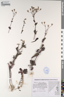
Senecio breviflorus (Kadereit) Greuter det. Byalt, Vyacheslav Vyacheslavovich
Collectors: Byalt, Vyacheslav Vyacheslavovich; Korshunov, Mikhail Vladimirovich Field collecting number: 303. Collection date: 11.03.2020. Administrative regions: AE - United Arab Emirates. Place of collection: Fujairah Emirate, Al Hayl Fort (Al Hayl Castle) [point 704]: near the Fort, on mountain side, on rock ledges.Groups of specimens: Образцы общего сектора; Соглашение Минобрнауки №075-15-2021-1056; Бялт В.В.: Флора ФуджейрыOriginal label text: United Arab Emirates, Fujairah Emirate, Al Hayl Fort (Al Hayl Castle). 25°5'4.59"N, 56°13'36.84"E, elevation 240–310 m [point 704]: near the Fort, on mountain side, on rock ledges, 11 III 2020, fl., V.V. Byalt, M.V. Korshunov 303

LE 01229487
Groups of specimens: Образцы сектора Восточной Европы; Соглашение Минобрнауки №075-15-2021-1056Record creation: 2023-03-21, Peter Efimov, PhotoScan D2.Citation: Specimen LE 01229487 // Virtual herbarium of Komarov Botanical Institute RAS — http://re.herbariumle.ru/01229487
LE 01229486
Groups of specimens: Образцы сектора Восточной Европы; Соглашение Минобрнауки №075-15-2021-1056Record creation: 2023-03-21, Peter Efimov, PhotoScan D2.Citation: Specimen LE 01229486 // Virtual herbarium of Komarov Botanical Institute RAS — http://re.herbariumle.ru/01229486
LE 01196412
Allium praemixtum Vved.
Groups of specimens: Образцы сектора Средней Азии; Типовые образцы сектора Средней Азии; Соглашение Минобрнауки №075-15-2021-1056Record creation: 2023-03-25, Mariya Sheludyakova, PhotoScan D2. Part 2.Citation: Specimen LE 01196412 // Virtual herbarium of Komarov Botanical Institute RAS — http://re.herbariumle.ru/01196412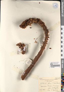
LE 01196088
Groups of specimens: Образцы сектора Средней Азии; Соглашение Минобрнауки №075-15-2021-1056Record creation: 2023-03-25, Mariya Sheludyakova, PhotoScan D2. Part 1.Citation: Specimen LE 01196088 // Virtual herbarium of Komarov Botanical Institute RAS — http://re.herbariumle.ru/01196088
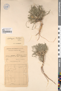
LE 01195955
Astragalus lasiophyllus Ledeb. det. Knjazev, Mikhail Sergeyevich
Groups of specimens: Образцы сектора Средней Азии; Соглашение Минобрнауки №075-15-2021-1056Record creation: 2023-03-24, Mariya Sheludyakova, PhotoScan D2. Part 2.Citation: Specimen LE 01195955 // Virtual herbarium of Komarov Botanical Institute RAS — http://re.herbariumle.ru/01195955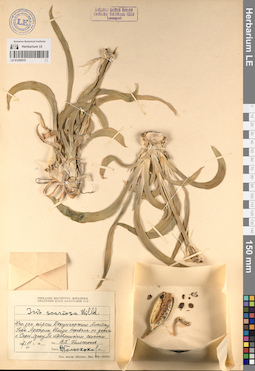
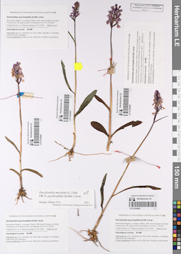
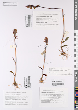
LE 01229579
Iris scariosa Willd. ex Link
Groups of specimens: Образцы сектора Средней Азии; Соглашение Минобрнауки №075-15-2021-1056Record creation: 2023-03-22, Artyom Leostrin, PhotoScan D2.Citation: Specimen LE 01229579 // Virtual herbarium of Komarov Botanical Institute RAS — http://re.herbariumle.ru/01229579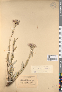
LE 01195895
Groups of specimens: Образцы сектора Средней Азии; Соглашение Минобрнауки №075-15-2021-1056Record creation: 2023-03-17, Mariya Sheludyakova, PhotoScan D2. Part 2.Citation: Specimen LE 01195895 // Virtual herbarium of Komarov Botanical Institute RAS — http://re.herbariumle.ru/01195895

LE 01229483
Groups of specimens: Образцы сектора Восточной Европы; Соглашение Минобрнауки №075-15-2021-1056Record creation: 2023-03-21, Peter Efimov, PhotoScan D2.Citation: Specimen LE 01229483 // Virtual herbarium of Komarov Botanical Institute RAS — http://re.herbariumle.ru/01229483
LE 01229484
Groups of specimens: Образцы сектора Восточной Европы; Соглашение Минобрнауки №075-15-2021-1056Record creation: 2023-03-21, Peter Efimov, PhotoScan D2.Citation: Specimen LE 01229484 // Virtual herbarium of Komarov Botanical Institute RAS — http://re.herbariumle.ru/01229484

LE 01229485
Groups of specimens: Образцы сектора Восточной Европы; Соглашение Минобрнауки №075-15-2021-1056Record creation: 2023-03-21, Peter Efimov, PhotoScan D2.Citation: Specimen LE 01229485 // Virtual herbarium of Komarov Botanical Institute RAS — http://re.herbariumle.ru/01229485

LE 01229482
Groups of specimens: Образцы сектора Восточной Европы; Соглашение Минобрнауки №075-15-2021-1056Record creation: 2023-03-21, Peter Efimov, PhotoScan D2.Citation: Specimen LE 01229482 // Virtual herbarium of Komarov Botanical Institute RAS — http://re.herbariumle.ru/01229482
LE 01193585
Ifloga spicata (Forssk.) Sch. Bip. det. Byalt, Vyacheslav Vyacheslavovich
Collectors: Byalt, Vyacheslav Vyacheslavovich; Korshunov, Mikhail Vladimirovich Field collecting number: 1026b. Collection date: 24.03.2020. Administrative regions: AE - United Arab Emirates. Place of collection: Fujairah emirate, cell tower on the mountain peak, 3.5 km West to Ghub, 8 km West-South-West to Dibba [point 719].Groups of specimens: Образцы общего сектора; Соглашение Минобрнауки №075-15-2021-1056; Бялт В.В.: Флора ФуджейрыOriginal label text: United Arab Emirates, Fujairah emirate, cell tower on the mountain peak, 3.5 km West to Ghub, 8 km West-South-West to Dibba. 25°34'14.16"N, 56° 9'58.28"E, elevation 765 m. [point 719]: on bagharah field, wet after rains, 24 III 2020, fr., V.V. Byalt, M.V. Korshunov 1026b
LE 01196087
Groups of specimens: Образцы сектора Средней Азии; Соглашение Минобрнауки №075-15-2021-1056Record creation: 2023-03-25, Mariya Sheludyakova, PhotoScan D2. Part 1.Citation: Specimen LE 01196087 // Virtual herbarium of Komarov Botanical Institute RAS — http://re.herbariumle.ru/01196087
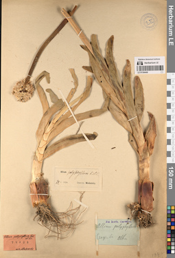
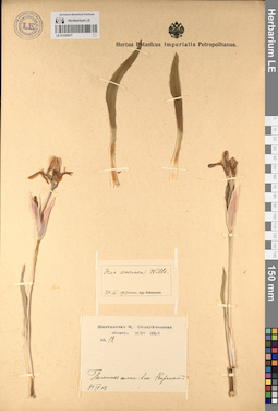
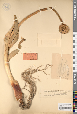
LE 01196411
Specimen originale of Allium polyphyllum Kar. & Kir.
Administrative regions: KZ - Kazakhstan. Place of collection: у реки Сархан (Шаркан).Groups of specimens: Образцы сектора Средней Азии; Типовые образцы сектора Средней Азии; Соглашение Минобрнауки №075-15-2021-1056Record creation: 2023-03-25, Mariya Sheludyakova, PhotoScan D2. Part 2.Citation: Specimen LE 01196411 // Virtual herbarium of Komarov Botanical Institute RAS — http://re.herbariumle.ru/01196411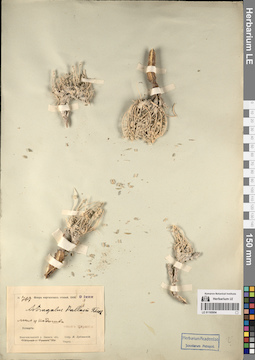
LE 01195954
Astragalus lasiophyllus Ledeb. det. Knjazev, Mikhail Sergeyevich
Groups of specimens: Образцы сектора Средней Азии; Соглашение Минобрнауки №075-15-2021-1056Record creation: 2023-03-24, Mariya Sheludyakova, PhotoScan D2. Part 2.Citation: Specimen LE 01195954 // Virtual herbarium of Komarov Botanical Institute RAS — http://re.herbariumle.ru/01195954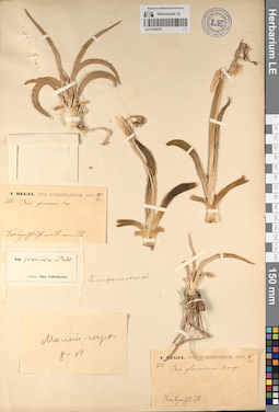
LE 01229578
Iris scariosa Willd. ex Link
Groups of specimens: Образцы сектора Средней Азии; Соглашение Минобрнауки №075-15-2021-1056Record creation: 2023-03-22, Artyom Leostrin, PhotoScan D2.Citation: Specimen LE 01229578 // Virtual herbarium of Komarov Botanical Institute RAS — http://re.herbariumle.ru/01229578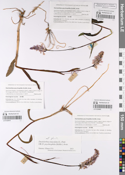
LE 01229481
Groups of specimens: Образцы сектора Восточной Европы; Соглашение Минобрнауки №075-15-2021-1056Record creation: 2023-03-21, Peter Efimov, PhotoScan D2.Citation: Specimen LE 01229481 // Virtual herbarium of Komarov Botanical Institute RAS — http://re.herbariumle.ru/01229481

LE 01229480
Groups of specimens: Образцы сектора Восточной Европы; Соглашение Минобрнауки №075-15-2021-1056Record creation: 2023-03-21, Peter Efimov, PhotoScan D2.Citation: Specimen LE 01229480 // Virtual herbarium of Komarov Botanical Institute RAS — http://re.herbariumle.ru/01229480

LE 01229479
Groups of specimens: Образцы сектора Восточной Европы; Соглашение Минобрнауки №075-15-2021-1056Record creation: 2023-03-21, Peter Efimov, PhotoScan D2.Citation: Specimen LE 01229479 // Virtual herbarium of Komarov Botanical Institute RAS — http://re.herbariumle.ru/01229479
LE 01195894
Groups of specimens: Образцы сектора Средней Азии; Соглашение Минобрнауки №075-15-2021-1056Record creation: 2023-03-17, Mariya Sheludyakova, PhotoScan D2. Part 2.Citation: Specimen LE 01195894 // Virtual herbarium of Komarov Botanical Institute RAS — http://re.herbariumle.ru/01195894
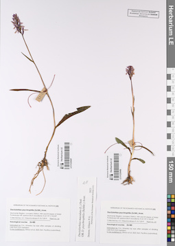
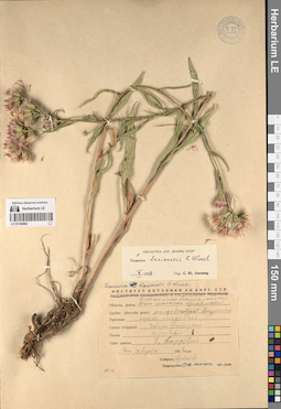
LE 01193584
Gynandriris sisyrinchium (L.) Parl. det. Byalt, Vyacheslav Vyacheslavovich
Collectors: Byalt, Vyacheslav Vyacheslavovich Field collecting number: 340. Collection date: 27.03.2017. Administrative regions: AE - United Arab Emirates. Place of collection: Фуджейра, окрестности пос. Тавайан, каменистое русло сухого ручья.Groups of specimens: Образцы общего сектора; Соглашение Минобрнауки №075-15-2021-1056; Бялт В.В.: Флора ФуджейрыOriginal label text:United Arab Emirates, Emirate of Fujaira, environs of Tawaian, ca. 25°38' N, 56° 07' E, 1000 m alt.: stony valley of dry creek. -- ОАЭ. Фуджейра, окрестности пос. Тавайан, 25°38' N, 56° 07' E, 1000 м н. ур. м.: каменистое русло сухого ручья. 27 III 2016. V.V. Byalt 340
Landscape in location of collection: каменистое русло сухого ручьяCoordinates (geographic position): 25° 38′ 0″ N, 56° 7′ 0″ E ±100 m, 1000 m a.s.l.Record creation: 2023-03-22, Larisa Orlova, PhotoScan D2.Citation: Specimen LE 01193584 // Virtual herbarium of Komarov Botanical Institute RAS — http://re.herbariumle.ru/01193584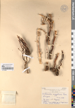
LE 01196086
Groups of specimens: Образцы сектора Средней Азии; Соглашение Минобрнауки №075-15-2021-1056Record creation: 2023-03-25, Mariya Sheludyakova, PhotoScan D2. Part 1.Citation: Specimen LE 01196086 // Virtual herbarium of Komarov Botanical Institute RAS — http://re.herbariumle.ru/01196086
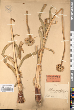
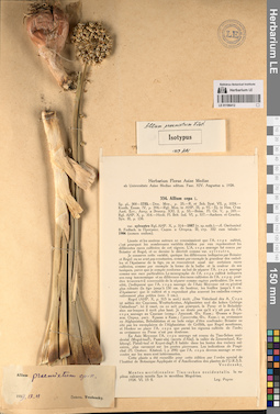
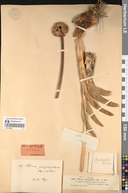
LE 01196410
Specimen originale of Allium polyphyllum Kar. & Kir.
Groups of specimens: Образцы сектора Средней Азии; Типовые образцы сектора Средней Азии; Соглашение Минобрнауки №075-15-2021-1056Record creation: 2023-03-25, Mariya Sheludyakova, PhotoScan D2. Part 2.Citation: Specimen LE 01196410 // Virtual herbarium of Komarov Botanical Institute RAS — http://re.herbariumle.ru/01196410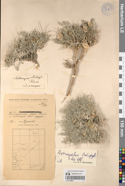
LE 01195953
Astragalus lasiophyllus Ledeb. det. Knjazev, Mikhail Sergeyevich
Groups of specimens: Образцы сектора Средней Азии; Соглашение Минобрнауки №075-15-2021-1056Record creation: 2023-03-24, Mariya Sheludyakova, PhotoScan D2. Part 2.Citation: Specimen LE 01195953 // Virtual herbarium of Komarov Botanical Institute RAS — http://re.herbariumle.ru/01195953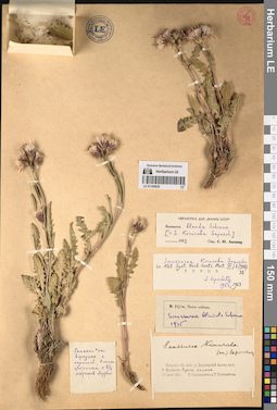
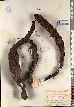
LE 01195935
Groups of specimens: Образцы сектора Средней Азии; Типовые образцы сектора Средней Азии; Соглашение Минобрнауки №075-15-2021-1056Record creation: 2023-03-17, Mariya Sheludyakova, PhotoScan D2. Part 3.Citation: Specimen LE 01195935 // Virtual herbarium of Komarov Botanical Institute RAS — http://re.herbariumle.ru/01195935

LE 01229478
Groups of specimens: Образцы сектора Восточной Европы; Соглашение Минобрнауки №075-15-2021-1056Record creation: 2023-03-21, Peter Efimov, PhotoScan D2.Citation: Specimen LE 01229478 // Virtual herbarium of Komarov Botanical Institute RAS — http://re.herbariumle.ru/01229478

LE 01229476
Groups of specimens: Образцы сектора Восточной Европы; Соглашение Минобрнауки №075-15-2021-1056Record creation: 2023-03-21, Peter Efimov, PhotoScan D2.Citation: Specimen LE 01229476 // Virtual herbarium of Komarov Botanical Institute RAS — http://re.herbariumle.ru/01229476
LE 01229477
Groups of specimens: Образцы сектора Восточной Европы; Соглашение Минобрнауки №075-15-2021-1056Record creation: 2023-03-21, Peter Efimov, PhotoScan D2.Citation: Specimen LE 01229477 // Virtual herbarium of Komarov Botanical Institute RAS — http://re.herbariumle.ru/01229477
LE 01229577
Iris scariosa Willd. ex Link
Groups of specimens: Образцы сектора Средней Азии; Соглашение Минобрнауки №075-15-2021-1056Record creation: 2023-03-22, Artyom Leostrin, PhotoScan D2.Citation: Specimen LE 01229577 // Virtual herbarium of Komarov Botanical Institute RAS — http://re.herbariumle.ru/01229577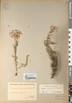
LE 01195893
Groups of specimens: Образцы сектора Средней Азии; Соглашение Минобрнауки №075-15-2021-1056Record creation: 2023-03-17, Mariya Sheludyakova, PhotoScan D2. Part 2.Citation: Specimen LE 01195893 // Virtual herbarium of Komarov Botanical Institute RAS — http://re.herbariumle.ru/01195893
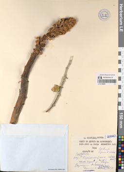
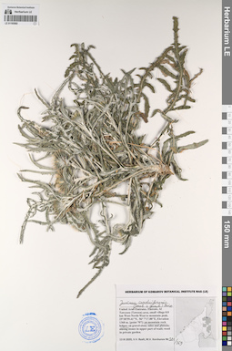
LE 01193583
Launaea bornmuelleri (Hausskn. ex Bornm.) Bornm. det. Byalt, Vyacheslav Vyacheslavovich
Additional identifications: Launaea spinosa (Forssk.) Sch. Bip. ex Kuntze det. Byalt, Vyacheslav Vyacheslavovich Collectors: Byalt, Vyacheslav Vyacheslavovich; Korshunov, Mikhail Vladimirovich Field collecting number: 1725. Collection date: 23.11.2019. Administrative regions: AE - United Arab Emirates. Place of collection: Фуджейра, горы Хаджар. Старая дорога Масафи-Дибба.Groups of specimens: Образцы общего сектора; Соглашение Минобрнауки №075-15-2021-1056; Бялт В.В.: Флора ФуджейрыOriginal label text: United Arab Emirates. Mts. Hajar. Old road Masafi-Dibba, 25°22'10"N 56°11'08"E, ca. 490 m alt.: on wadi side slopes, on rocks. – ОАЭ, Фуджейра, горы Хаджар. Старая дорога Масафи-Дибба, 25 ° 22'10 "N 56 ° 11'08" E, ок. 490 м над уровнем моря: боковые склоны вади, на скалах, 23 XI 2019, veg., V.V. Byalt, M.V. Korshunov 1725
LE 01196085
Groups of specimens: Образцы сектора Средней Азии; Соглашение Минобрнауки №075-15-2021-1056Record creation: 2023-03-25, Mariya Sheludyakova, PhotoScan D2. Part 1.Citation: Specimen LE 01196085 // Virtual herbarium of Komarov Botanical Institute RAS — http://re.herbariumle.ru/01196085
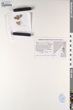
LE 01047630
Groups of specimens: Образцы сектора Средней Азии; Типовые образцы сектора Средней Азии; Соглашение Минобрнауки №075-15-2021-1056Record creation: 2023-03-24, Alexey Grebenjuk, PhotoScan D2.Citation: Specimen LE 01047630 // Virtual herbarium of Komarov Botanical Institute RAS — http://re.herbariumle.ru/01047630
LE 01196409
Specimen originale of Allium polyphyllum Kar. & Kir.
Administrative regions: KZ - Kazakhstan. Place of collection: у реки Сархан (Шаркан).Groups of specimens: Образцы сектора Средней Азии; Типовые образцы сектора Средней Азии; Соглашение Минобрнауки №075-15-2021-1056Record creation: 2023-03-25, Mariya Sheludyakova, PhotoScan D2. Part 2.Citation: Specimen LE 01196409 // Virtual herbarium of Komarov Botanical Institute RAS — http://re.herbariumle.ru/01196409
LE 01229473
Groups of specimens: Образцы сектора Восточной Европы; Соглашение Минобрнауки №075-15-2021-1056Record creation: 2023-03-21, Peter Efimov, PhotoScan D2.Citation: Specimen LE 01229473 // Virtual herbarium of Komarov Botanical Institute RAS — http://re.herbariumle.ru/01229473
LE 01229475
Groups of specimens: Образцы сектора Восточной Европы; Соглашение Минобрнауки №075-15-2021-1056Record creation: 2023-03-21, Peter Efimov, PhotoScan D2.Citation: Specimen LE 01229475 // Virtual herbarium of Komarov Botanical Institute RAS — http://re.herbariumle.ru/01229475

LE 01229474
Groups of specimens: Образцы сектора Восточной Европы; Соглашение Минобрнауки №075-15-2021-1056Record creation: 2023-03-21, Peter Efimov, PhotoScan D2.Citation: Specimen LE 01229474 // Virtual herbarium of Komarov Botanical Institute RAS — http://re.herbariumle.ru/01229474
LE 01195952
Astragalus lasiophyllus Ledeb. det. Knjazev, Mikhail Sergeyevich
Groups of specimens: Образцы сектора Средней Азии; Соглашение Минобрнауки №075-15-2021-1056Record creation: 2023-03-24, Mariya Sheludyakova, PhotoScan D2. Part 2.Citation: Specimen LE 01195952 // Virtual herbarium of Komarov Botanical Institute RAS — http://re.herbariumle.ru/01195952
LE 01195934
Groups of specimens: Образцы сектора Средней Азии; Типовые образцы сектора Средней Азии; Соглашение Минобрнауки №075-15-2021-1056Record creation: 2023-03-17, Mariya Sheludyakova, PhotoScan D2. Part 3.Citation: Specimen LE 01195934 // Virtual herbarium of Komarov Botanical Institute RAS — http://re.herbariumle.ru/01195934
LE 01229576
Iris scariosa Willd. ex Link
Groups of specimens: Образцы сектора Средней Азии; Соглашение Минобрнауки №075-15-2021-1056Record creation: 2023-03-22, Artyom Leostrin, PhotoScan D2.Citation: Specimen LE 01229576 // Virtual herbarium of Komarov Botanical Institute RAS — http://re.herbariumle.ru/01229576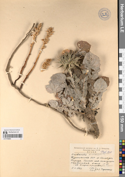
LE 01196084
Groups of specimens: Образцы сектора Средней Азии; Соглашение Минобрнауки №075-15-2021-1056Record creation: 2023-03-25, Mariya Sheludyakova, PhotoScan D2. Part 1.Citation: Specimen LE 01196084 // Virtual herbarium of Komarov Botanical Institute RAS — http://re.herbariumle.ru/01196084
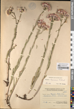
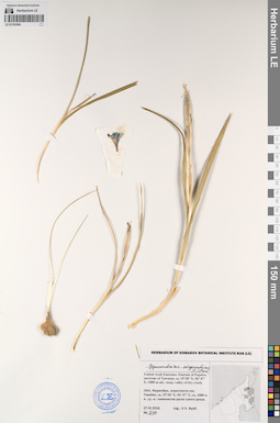
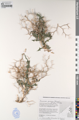
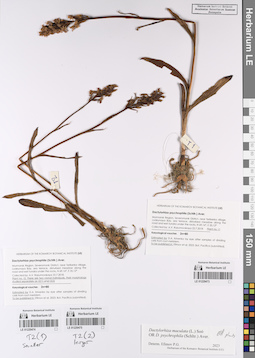
LE 01193582
Jurinea carduiformis (Jaub. et Spach) Boiss. det. Byalt, Vyacheslav Vyacheslavovich
Collectors: Byalt, Vyacheslav Vyacheslavovich; Korshunov, Mikhail Vladimirovich Field collecting number: 381/369. Collection date: 13.03.2020. Administrative regions: AE - United Arab Emirates. Place of collection: Al Tawyeen (Taween) area, small village 0.8 km West-North-West to mountain peak [point 707].Groups of specimens: Образцы общего сектора; Соглашение Минобрнауки №075-15-2021-1056; Бялт В.В.: Флора ФуджейрыOriginal label text: United Arab Emirates, Fujairah Emirate, Al Tawyeen (Taween) area, small village 0.8 km West-North-West to mountain peak. 25°38'59.41"N, 56° 7'17.88"E, elevation 1360 m. [point 707]: on mountain rock ledges, 13 III 2020, fl. juv., V.V. Byalt, M.V. Korshunov 381/369
LE 01195892
Groups of specimens: Образцы сектора Средней Азии; Соглашение Минобрнауки №075-15-2021-1056Record creation: 2023-03-17, Mariya Sheludyakova, PhotoScan D2. Part 2.Citation: Specimen LE 01195892 // Virtual herbarium of Komarov Botanical Institute RAS — http://re.herbariumle.ru/01195892

LE 01229472
Groups of specimens: Образцы сектора Восточной Европы; Соглашение Минобрнауки №075-15-2021-1056Record creation: 2023-03-21, Peter Efimov, PhotoScan D2.Citation: Specimen LE 01229472 // Virtual herbarium of Komarov Botanical Institute RAS — http://re.herbariumle.ru/01229472
LE 01229468
Groups of specimens: Образцы сектора Восточной Европы; Соглашение Минобрнауки №075-15-2021-1056Record creation: 2023-03-21, Peter Efimov, PhotoScan D2.Citation: Specimen LE 01229468 // Virtual herbarium of Komarov Botanical Institute RAS — http://re.herbariumle.ru/01229468

LE 01229469
Groups of specimens: Образцы сектора Восточной Европы; Соглашение Минобрнауки №075-15-2021-1056Record creation: 2023-03-21, Peter Efimov, PhotoScan D2.Citation: Specimen LE 01229469 // Virtual herbarium of Komarov Botanical Institute RAS — http://re.herbariumle.ru/01229469

LE 01229470
Groups of specimens: Образцы сектора Восточной Европы; Соглашение Минобрнауки №075-15-2021-1056Record creation: 2023-03-21, Peter Efimov, PhotoScan D2.Citation: Specimen LE 01229470 // Virtual herbarium of Komarov Botanical Institute RAS — http://re.herbariumle.ru/01229470

LE 01229471
Groups of specimens: Образцы сектора Восточной Европы; Соглашение Минобрнауки №075-15-2021-1056Record creation: 2023-03-21, Peter Efimov, PhotoScan D2.Citation: Specimen LE 01229471 // Virtual herbarium of Komarov Botanical Institute RAS — http://re.herbariumle.ru/01229471