View
Add
Copy
Edit
Delete
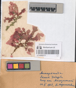
LE A0002171
Groups of specimens: Algae specimens; Соглашение Минобрнауки №075-15-2021-1056Record creation: 2023-04-17, Vera Stepanova.Citation: Specimen LE A0002171 // Virtual herbarium of Komarov Botanical Institute RAS — http://re.herbariumle.ru/A0002171
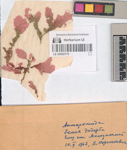
LE A0002170
Groups of specimens: Algae specimens; Соглашение Минобрнауки №075-15-2021-1056Record creation: 2023-04-17, Vera Stepanova.Citation: Specimen LE A0002170 // Virtual herbarium of Komarov Botanical Institute RAS — http://re.herbariumle.ru/A0002170

LE 01236239
Iris songarica Schrenk
Groups of specimens: Образцы сектора Средней Азии; Соглашение Минобрнауки №075-15-2021-1056Record creation: 2023-04-22, Artyom Leostrin, PhotoScan D2.Citation: Specimen LE 01236239 // Virtual herbarium of Komarov Botanical Institute RAS — http://re.herbariumle.ru/01236239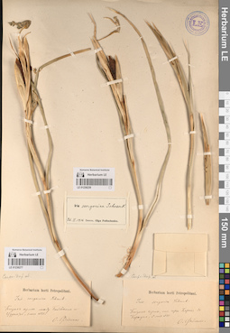
LE 01236277
Iris songarica Schrenk
Groups of specimens: Образцы сектора Средней Азии; Соглашение Минобрнауки №075-15-2021-1056Record creation: 2023-04-22, Artyom Leostrin, PhotoScan D2.Citation: Specimen LE 01236277 // Virtual herbarium of Komarov Botanical Institute RAS — http://re.herbariumle.ru/01236277
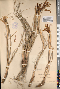
LE 01236236
Iris songarica Schrenk
Groups of specimens: Образцы сектора Средней Азии; Соглашение Минобрнауки №075-15-2021-1056Record creation: 2023-04-22, Artyom Leostrin, PhotoScan D2.Citation: Specimen LE 01236236 // Virtual herbarium of Komarov Botanical Institute RAS — http://re.herbariumle.ru/01236236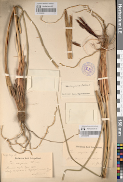
LE 01236276
Iris songarica Schrenk
Groups of specimens: Образцы сектора Средней Азии; Соглашение Минобрнауки №075-15-2021-1056Record creation: 2023-04-22, Artyom Leostrin, PhotoScan D2.Citation: Specimen LE 01236276 // Virtual herbarium of Komarov Botanical Institute RAS — http://re.herbariumle.ru/01236276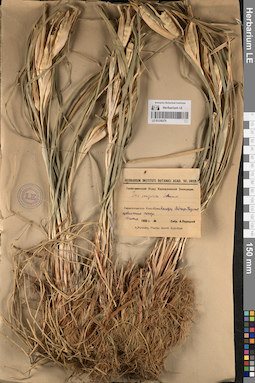
LE 01236275
Iris songarica Schrenk
Groups of specimens: Образцы сектора Средней Азии; Соглашение Минобрнауки №075-15-2021-1056Record creation: 2023-04-22, Artyom Leostrin, PhotoScan D2.Citation: Specimen LE 01236275 // Virtual herbarium of Komarov Botanical Institute RAS — http://re.herbariumle.ru/01236275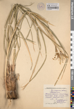
LE 01236274
Iris songarica Schrenk
Groups of specimens: Образцы сектора Средней Азии; Соглашение Минобрнауки №075-15-2021-1056Record creation: 2023-04-22, Artyom Leostrin, PhotoScan D2.Citation: Specimen LE 01236274 // Virtual herbarium of Komarov Botanical Institute RAS — http://re.herbariumle.ru/01236274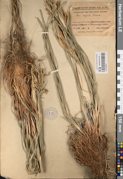
LE 01236273
Iris songarica Schrenk
Groups of specimens: Образцы сектора Средней Азии; Соглашение Минобрнауки №075-15-2021-1056Record creation: 2023-04-22, Artyom Leostrin, PhotoScan D2.Citation: Specimen LE 01236273 // Virtual herbarium of Komarov Botanical Institute RAS — http://re.herbariumle.ru/01236273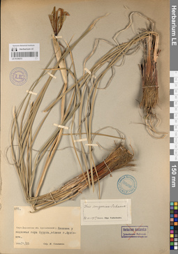
LE 01236272
Iris songarica Schrenk
Groups of specimens: Образцы сектора Средней Азии; Соглашение Минобрнауки №075-15-2021-1056Record creation: 2023-04-22, Artyom Leostrin, PhotoScan D2.Citation: Specimen LE 01236272 // Virtual herbarium of Komarov Botanical Institute RAS — http://re.herbariumle.ru/01236272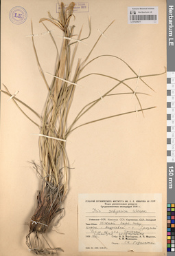
LE 01236271
Iris songarica Schrenk
Groups of specimens: Образцы сектора Средней Азии; Соглашение Минобрнауки №075-15-2021-1056Record creation: 2023-04-22, Artyom Leostrin, PhotoScan D2.Citation: Specimen LE 01236271 // Virtual herbarium of Komarov Botanical Institute RAS — http://re.herbariumle.ru/01236271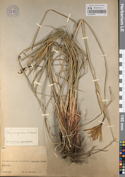
LE 01236270
Iris songarica Schrenk
Groups of specimens: Образцы сектора Средней Азии; Соглашение Минобрнауки №075-15-2021-1056Record creation: 2023-04-22, Artyom Leostrin, PhotoScan D2.Citation: Specimen LE 01236270 // Virtual herbarium of Komarov Botanical Institute RAS — http://re.herbariumle.ru/01236270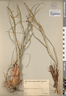
LE 01236269
Iris songarica Schrenk
Groups of specimens: Образцы сектора Средней Азии; Соглашение Минобрнауки №075-15-2021-1056Record creation: 2023-04-22, Artyom Leostrin, PhotoScan D2.Citation: Specimen LE 01236269 // Virtual herbarium of Komarov Botanical Institute RAS — http://re.herbariumle.ru/01236269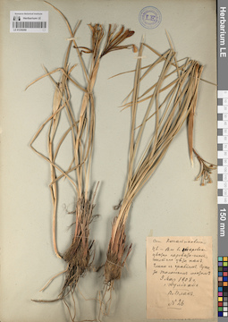
LE 01236268
Iris songarica Schrenk
Groups of specimens: Образцы сектора Средней Азии; Соглашение Минобрнауки №075-15-2021-1056Record creation: 2023-04-22, Artyom Leostrin, PhotoScan D2.Citation: Specimen LE 01236268 // Virtual herbarium of Komarov Botanical Institute RAS — http://re.herbariumle.ru/01236268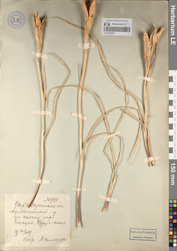
LE 01236267
Iris songarica Schrenk
Groups of specimens: Образцы сектора Средней Азии; Соглашение Минобрнауки №075-15-2021-1056Record creation: 2023-04-22, Artyom Leostrin, PhotoScan D2.Citation: Specimen LE 01236267 // Virtual herbarium of Komarov Botanical Institute RAS — http://re.herbariumle.ru/01236267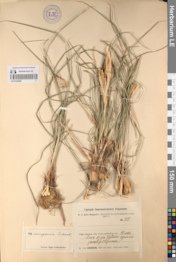
LE 01236266
Iris songarica Schrenk
Groups of specimens: Образцы сектора Средней Азии; Соглашение Минобрнауки №075-15-2021-1056Record creation: 2023-04-22, Artyom Leostrin, PhotoScan D2.Citation: Specimen LE 01236266 // Virtual herbarium of Komarov Botanical Institute RAS — http://re.herbariumle.ru/01236266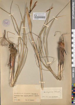
LE 01236265
Iris songarica Schrenk
Groups of specimens: Образцы сектора Средней Азии; Соглашение Минобрнауки №075-15-2021-1056Record creation: 2023-04-22, Artyom Leostrin, PhotoScan D2.Citation: Specimen LE 01236265 // Virtual herbarium of Komarov Botanical Institute RAS — http://re.herbariumle.ru/01236265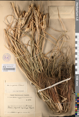
LE 01236264
Iris songarica Schrenk
Groups of specimens: Образцы сектора Средней Азии; Соглашение Минобрнауки №075-15-2021-1056Record creation: 2023-04-22, Artyom Leostrin, PhotoScan D2.Citation: Specimen LE 01236264 // Virtual herbarium of Komarov Botanical Institute RAS — http://re.herbariumle.ru/01236264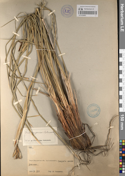
LE 01236263
Iris songarica Schrenk
Groups of specimens: Образцы сектора Средней Азии; Соглашение Минобрнауки №075-15-2021-1056Record creation: 2023-04-22, Artyom Leostrin, PhotoScan D2.Citation: Specimen LE 01236263 // Virtual herbarium of Komarov Botanical Institute RAS — http://re.herbariumle.ru/01236263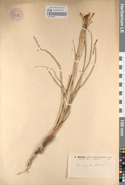
LE 01236262
Iris songarica Schrenk
Groups of specimens: Образцы сектора Средней Азии; Соглашение Минобрнауки №075-15-2021-1056Record creation: 2023-04-22, Artyom Leostrin, PhotoScan D2.Citation: Specimen LE 01236262 // Virtual herbarium of Komarov Botanical Institute RAS — http://re.herbariumle.ru/01236262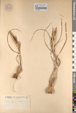
LE 01236261
Iris songarica Schrenk
Groups of specimens: Образцы сектора Средней Азии; Соглашение Минобрнауки №075-15-2021-1056Record creation: 2023-04-22, Artyom Leostrin, PhotoScan D2.Citation: Specimen LE 01236261 // Virtual herbarium of Komarov Botanical Institute RAS — http://re.herbariumle.ru/01236261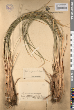
LE 01236260
Iris songarica Schrenk
Groups of specimens: Образцы сектора Средней Азии; Соглашение Минобрнауки №075-15-2021-1056Record creation: 2023-04-22, Artyom Leostrin, PhotoScan D2.Citation: Specimen LE 01236260 // Virtual herbarium of Komarov Botanical Institute RAS — http://re.herbariumle.ru/01236260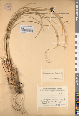
LE 01236259
Iris songarica Schrenk
Groups of specimens: Образцы сектора Средней Азии; Соглашение Минобрнауки №075-15-2021-1056Record creation: 2023-04-22, Artyom Leostrin, PhotoScan D2.Citation: Specimen LE 01236259 // Virtual herbarium of Komarov Botanical Institute RAS — http://re.herbariumle.ru/01236259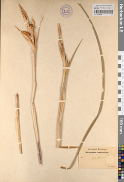
LE 01236258
Iris songarica Schrenk
Groups of specimens: Образцы сектора Средней Азии; Соглашение Минобрнауки №075-15-2021-1056Record creation: 2023-04-22, Artyom Leostrin, PhotoScan D2.Citation: Specimen LE 01236258 // Virtual herbarium of Komarov Botanical Institute RAS — http://re.herbariumle.ru/01236258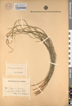
LE 01236257
Iris songarica Schrenk
Groups of specimens: Образцы сектора Средней Азии; Соглашение Минобрнауки №075-15-2021-1056Record creation: 2023-04-22, Artyom Leostrin, PhotoScan D2.Citation: Specimen LE 01236257 // Virtual herbarium of Komarov Botanical Institute RAS — http://re.herbariumle.ru/01236257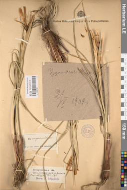
LE 01236169
Iris songarica Schrenk
Groups of specimens: Образцы сектора Средней Азии; Соглашение Минобрнауки №075-15-2021-1056Record creation: 2023-04-21, Artyom Leostrin, PhotoScan D2.Citation: Specimen LE 01236169 // Virtual herbarium of Komarov Botanical Institute RAS — http://re.herbariumle.ru/01236169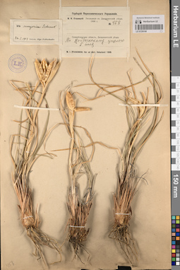
LE 01236168
Iris songarica Schrenk
Groups of specimens: Образцы сектора Средней Азии; Соглашение Минобрнауки №075-15-2021-1056Record creation: 2023-04-21, Artyom Leostrin, PhotoScan D2.Citation: Specimen LE 01236168 // Virtual herbarium of Komarov Botanical Institute RAS — http://re.herbariumle.ru/01236168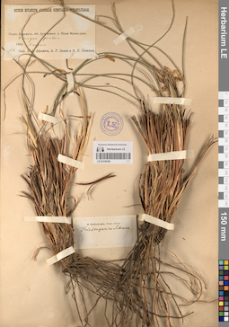
LE 01236256
Iris songarica Schrenk
Groups of specimens: Образцы сектора Средней Азии; Соглашение Минобрнауки №075-15-2021-1056Record creation: 2023-04-22, Artyom Leostrin, PhotoScan D2.Citation: Specimen LE 01236256 // Virtual herbarium of Komarov Botanical Institute RAS — http://re.herbariumle.ru/01236256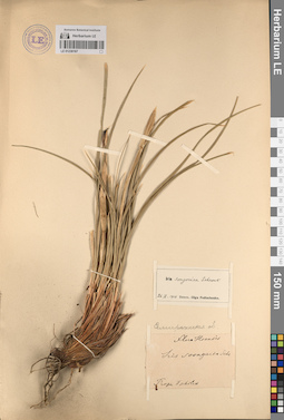
LE 01236167
Iris songarica Schrenk
Groups of specimens: Образцы сектора Средней Азии; Соглашение Минобрнауки №075-15-2021-1056Record creation: 2023-04-21, Artyom Leostrin, PhotoScan D2.Citation: Specimen LE 01236167 // Virtual herbarium of Komarov Botanical Institute RAS — http://re.herbariumle.ru/01236167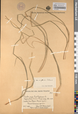
LE 01236255
Iris songarica Schrenk
Groups of specimens: Образцы сектора Средней Азии; Соглашение Минобрнауки №075-15-2021-1056Record creation: 2023-04-22, Artyom Leostrin, PhotoScan D2.Citation: Specimen LE 01236255 // Virtual herbarium of Komarov Botanical Institute RAS — http://re.herbariumle.ru/01236255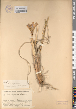
LE 01236166
Iris songarica Schrenk
Groups of specimens: Образцы сектора Средней Азии; Соглашение Минобрнауки №075-15-2021-1056Record creation: 2023-04-21, Artyom Leostrin, PhotoScan D2.Citation: Specimen LE 01236166 // Virtual herbarium of Komarov Botanical Institute RAS — http://re.herbariumle.ru/01236166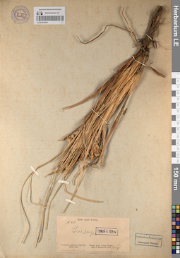
LE 01236254
Iris songarica Schrenk
Groups of specimens: Образцы сектора Средней Азии; Соглашение Минобрнауки №075-15-2021-1056Record creation: 2023-04-22, Artyom Leostrin, PhotoScan D2.Citation: Specimen LE 01236254 // Virtual herbarium of Komarov Botanical Institute RAS — http://re.herbariumle.ru/01236254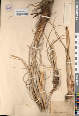
LE 01236165
Iris songarica Schrenk
Groups of specimens: Образцы сектора Средней Азии; Соглашение Минобрнауки №075-15-2021-1056Record creation: 2023-04-21, Artyom Leostrin, PhotoScan D2.Citation: Specimen LE 01236165 // Virtual herbarium of Komarov Botanical Institute RAS — http://re.herbariumle.ru/01236165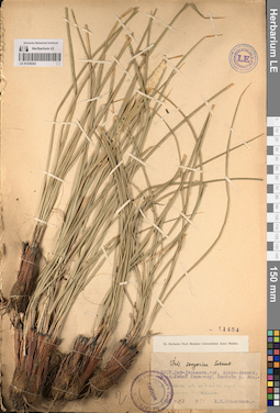
LE 01236253
Iris songarica Schrenk
Groups of specimens: Образцы сектора Средней Азии; Соглашение Минобрнауки №075-15-2021-1056Record creation: 2023-04-22, Artyom Leostrin, PhotoScan D2.Citation: Specimen LE 01236253 // Virtual herbarium of Komarov Botanical Institute RAS — http://re.herbariumle.ru/01236253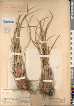
LE 01236164
Iris songarica Schrenk
Groups of specimens: Образцы сектора Средней Азии; Соглашение Минобрнауки №075-15-2021-1056Record creation: 2023-04-21, Artyom Leostrin, PhotoScan D2.Citation: Specimen LE 01236164 // Virtual herbarium of Komarov Botanical Institute RAS — http://re.herbariumle.ru/01236164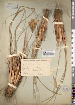
LE 01236252
Groups of specimens: Образцы сектора Средней Азии; Соглашение Минобрнауки №075-15-2021-1056Record creation: 2023-04-22, Artyom Leostrin, PhotoScan D2.Citation: Specimen LE 01236252 // Virtual herbarium of Komarov Botanical Institute RAS — http://re.herbariumle.ru/01236252
LE 01236163
Iris songarica Schrenk
Groups of specimens: Образцы сектора Средней Азии; Соглашение Минобрнауки №075-15-2021-1056Record creation: 2023-04-21, Artyom Leostrin, PhotoScan D2.Citation: Specimen LE 01236163 // Virtual herbarium of Komarov Botanical Institute RAS — http://re.herbariumle.ru/01236163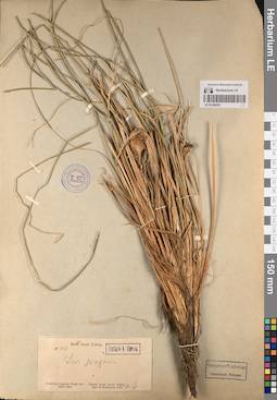
LE 01236251
Iris songarica Schrenk
Groups of specimens: Образцы сектора Средней Азии; Соглашение Минобрнауки №075-15-2021-1056Record creation: 2023-04-22, Artyom Leostrin, PhotoScan D2.Citation: Specimen LE 01236251 // Virtual herbarium of Komarov Botanical Institute RAS — http://re.herbariumle.ru/01236251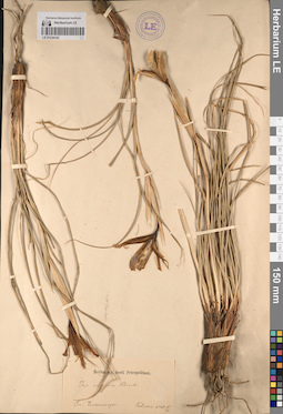
LE 01236162
Iris songarica Schrenk
Groups of specimens: Образцы сектора Средней Азии; Соглашение Минобрнауки №075-15-2021-1056Record creation: 2023-04-21, Artyom Leostrin, PhotoScan D2.Citation: Specimen LE 01236162 // Virtual herbarium of Komarov Botanical Institute RAS — http://re.herbariumle.ru/01236162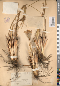
LE 01236250
Iris songarica Schrenk
Groups of specimens: Образцы сектора Средней Азии; Соглашение Минобрнауки №075-15-2021-1056Record creation: 2023-04-22, Artyom Leostrin, PhotoScan D2.Citation: Specimen LE 01236250 // Virtual herbarium of Komarov Botanical Institute RAS — http://re.herbariumle.ru/01236250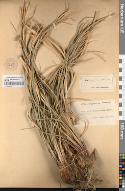
LE 01236161
Iris songarica Schrenk
Groups of specimens: Образцы сектора Средней Азии; Соглашение Минобрнауки №075-15-2021-1056Record creation: 2023-04-21, Artyom Leostrin, PhotoScan D2.Citation: Specimen LE 01236161 // Virtual herbarium of Komarov Botanical Institute RAS — http://re.herbariumle.ru/01236161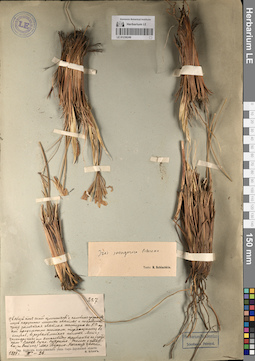
LE 01236249
Iris songarica Schrenk
Groups of specimens: Образцы сектора Средней Азии; Соглашение Минобрнауки №075-15-2021-1056Record creation: 2023-04-22, Artyom Leostrin, PhotoScan D2.Citation: Specimen LE 01236249 // Virtual herbarium of Komarov Botanical Institute RAS — http://re.herbariumle.ru/01236249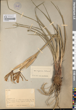
LE 01236160
Iris songarica Schrenk
Groups of specimens: Образцы сектора Средней Азии; Соглашение Минобрнауки №075-15-2021-1056Record creation: 2023-04-21, Artyom Leostrin, PhotoScan D2.Citation: Specimen LE 01236160 // Virtual herbarium of Komarov Botanical Institute RAS — http://re.herbariumle.ru/01236160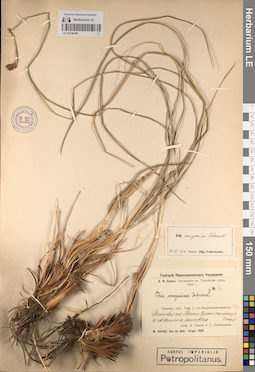
LE 01236248
Iris songarica Schrenk
Groups of specimens: Образцы сектора Средней Азии; Соглашение Минобрнауки №075-15-2021-1056Record creation: 2023-04-22, Artyom Leostrin, PhotoScan D2.Citation: Specimen LE 01236248 // Virtual herbarium of Komarov Botanical Institute RAS — http://re.herbariumle.ru/01236248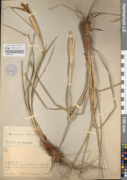
LE 01236159
Iris songarica Schrenk
Groups of specimens: Образцы сектора Средней Азии; Соглашение Минобрнауки №075-15-2021-1056Record creation: 2023-04-21, Artyom Leostrin, PhotoScan D2.Citation: Specimen LE 01236159 // Virtual herbarium of Komarov Botanical Institute RAS — http://re.herbariumle.ru/01236159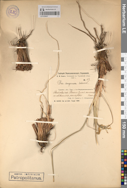
LE 01236247
Iris songarica Schrenk
Groups of specimens: Образцы сектора Средней Азии; Соглашение Минобрнауки №075-15-2021-1056Record creation: 2023-04-22, Artyom Leostrin, PhotoScan D2.Citation: Specimen LE 01236247 // Virtual herbarium of Komarov Botanical Institute RAS — http://re.herbariumle.ru/01236247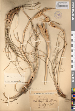
LE 01236158
Iris songarica Schrenk
Groups of specimens: Образцы сектора Средней Азии; Соглашение Минобрнауки №075-15-2021-1056Record creation: 2023-04-21, Artyom Leostrin, PhotoScan D2.Citation: Specimen LE 01236158 // Virtual herbarium of Komarov Botanical Institute RAS — http://re.herbariumle.ru/01236158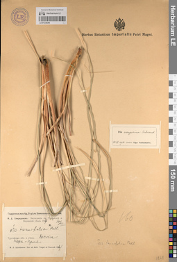
LE 01236246
Iris songarica Schrenk
Groups of specimens: Образцы сектора Средней Азии; Соглашение Минобрнауки №075-15-2021-1056Record creation: 2023-04-22, Artyom Leostrin, PhotoScan D2.Citation: Specimen LE 01236246 // Virtual herbarium of Komarov Botanical Institute RAS — http://re.herbariumle.ru/01236246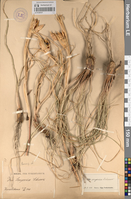
LE 01236157
Iris songarica Schrenk
Groups of specimens: Образцы сектора Средней Азии; Соглашение Минобрнауки №075-15-2021-1056Record creation: 2023-04-21, Artyom Leostrin, PhotoScan D2.Citation: Specimen LE 01236157 // Virtual herbarium of Komarov Botanical Institute RAS — http://re.herbariumle.ru/01236157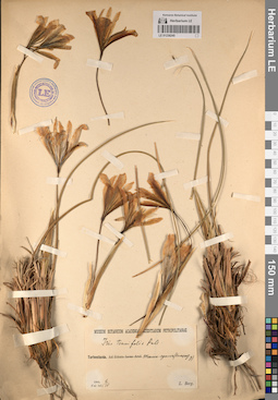
LE 01236245
Groups of specimens: Образцы сектора Средней Азии; Соглашение Минобрнауки №075-15-2021-1056Record creation: 2023-04-22, Artyom Leostrin, PhotoScan D2.Citation: Specimen LE 01236245 // Virtual herbarium of Komarov Botanical Institute RAS — http://re.herbariumle.ru/01236245