View
Add
Copy
Edit
Delete
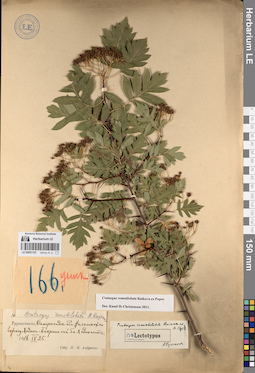
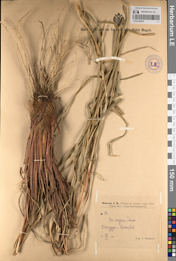
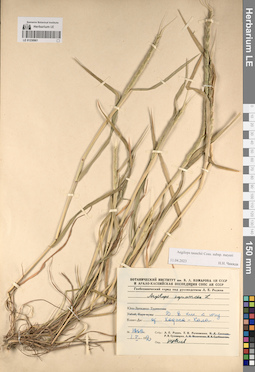
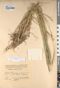
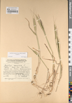
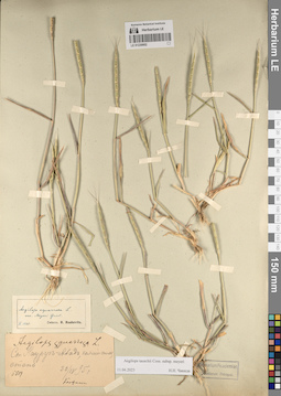
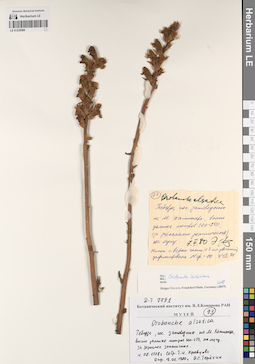
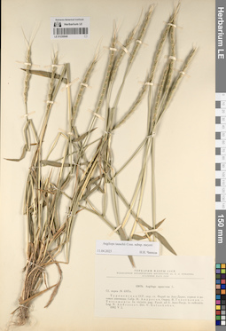
LE 00051157
Groups of specimens: Образцы сектора Средней Азии; Типовые образцы сектора Средней Азии; Соглашение Минобрнауки №075-15-2021-1056Record creation: 2023-04-24, Alexey Grebenjuk, PhotoScan D2. Part 2.Citation: Specimen LE 00051157 // Virtual herbarium of Komarov Botanical Institute RAS — http://re.herbariumle.ru/00051157
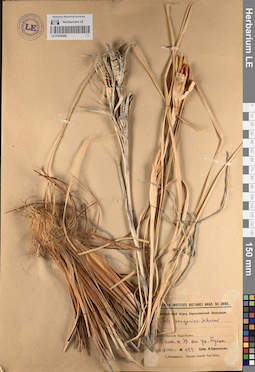
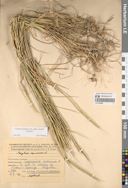
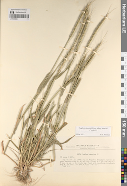
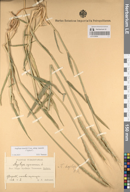
LE 01236280
Iris songarica Schrenk
Groups of specimens: Образцы сектора Средней Азии; Соглашение Минобрнауки №075-15-2021-1056Record creation: 2023-04-24, Artyom Leostrin, PhotoScan D2.Citation: Specimen LE 01236280 // Virtual herbarium of Komarov Botanical Institute RAS — http://re.herbariumle.ru/01236280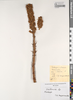
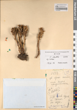
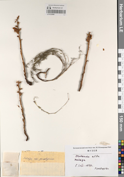
LE 01235104
Groups of specimens: Образцы сектора Кавказа; Соглашение Минобрнауки №075-15-2021-1056Record creation: 2023-04-27, Ivan Tatanov, PhotoScan D2. Part 1.Citation: Specimen LE 01235104 // Virtual herbarium of Komarov Botanical Institute RAS — http://re.herbariumle.ru/01235104
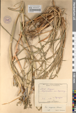
LE 01236351
Iris songarica Schrenk
Groups of specimens: Образцы сектора Средней Азии; Соглашение Минобрнауки №075-15-2021-1056Record creation: 2023-04-25, Artyom Leostrin, PhotoScan D2. Part 2.Citation: Specimen LE 01236351 // Virtual herbarium of Komarov Botanical Institute RAS — http://re.herbariumle.ru/01236351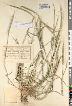
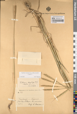
LE 01230964
Groups of specimens: Образцы сектора Средней Азии; Соглашение Минобрнауки №075-15-2021-1056Record creation: 2023-04-27, Ivan Tatanov, PhotoScan D2. Part 2.Citation: Specimen LE 01230964 // Virtual herbarium of Komarov Botanical Institute RAS — http://re.herbariumle.ru/01230964
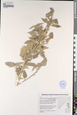
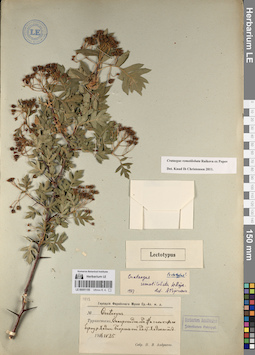
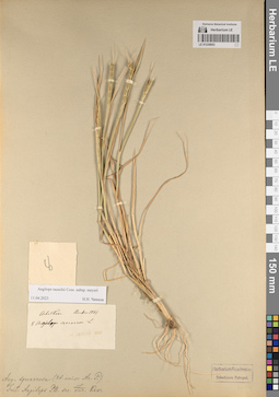
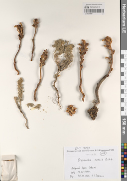
LE 01193949
Chrozophora oblongifolia (Delile) A.Juss. ex Spreng. det. Byalt, Vyacheslav Vyacheslavovich
Collectors: Byalt, Vyacheslav Vyacheslavovich; Korshunov, Mikhail Vladimirovich Field collecting number: 1449. Collection date: 22.11.2019. Administrative regions: AE - United Arab Emirates. Place of collection: Фуджейра, 0,3 км к западу от Кальбы, Кальбинская дамба: сухие каменисто-щебнистые берега озера (пруда).Groups of specimens: Образцы общего сектора; Соглашение Минобрнауки №075-15-2021-1056; Бялт В.В.: Флора ФуджейрыOriginal label text: United Arab Emirates. Emirate of Fujaira, 0.3 km to W from Kalba, 25°00'33.51"N 56°19'17.58"E, 48 m alt., Kalba dam: dry gravel-stony shores of lake.– ОАЭ, Фуджейра, 0,3 км к западу от Кальбы, 25°00'33.51"N 56°19'17.58"E, 48 м н.ур.м., Кальбинская дамба: сухие каменисто-щебнистые берега озера (пруда), 22 XI 2019 V.V. Byalt, M.V. Korshunov 1449
LE 00051156
Groups of specimens: Образцы сектора Средней Азии; Типовые образцы сектора Средней Азии; Соглашение Минобрнауки №075-15-2021-1056Record creation: 2023-04-24, Alexey Grebenjuk, PhotoScan D2. Part 2.Citation: Specimen LE 00051156 // Virtual herbarium of Komarov Botanical Institute RAS — http://re.herbariumle.ru/00051156
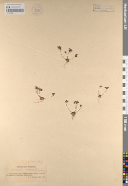
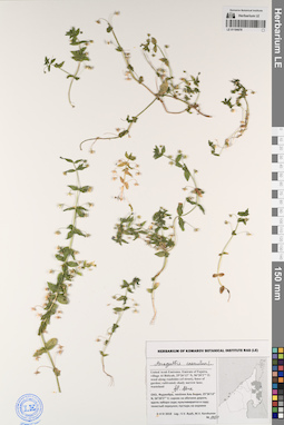
LE 01236532
Androsace elongata L.
Groups of specimens: Образцы сектора Центральной и Восточной Азии; Соглашение Минобрнауки №075-15-2021-1056Record creation: 2023-04-25, Artyom Leostrin, PhotoScan D2. Part 1.Citation: Specimen LE 01236532 // Virtual herbarium of Komarov Botanical Institute RAS — http://re.herbariumle.ru/01236532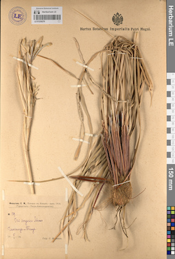
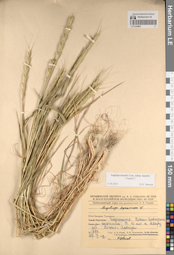
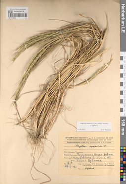
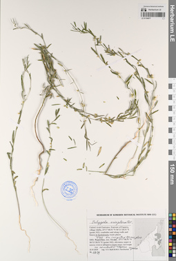
LE 01236279
Iris songarica Schrenk
Groups of specimens: Образцы сектора Средней Азии; Соглашение Минобрнауки №075-15-2021-1056Record creation: 2023-04-24, Artyom Leostrin, PhotoScan D2.Citation: Specimen LE 01236279 // Virtual herbarium of Komarov Botanical Institute RAS — http://re.herbariumle.ru/01236279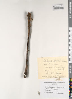
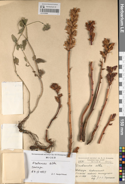
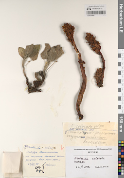
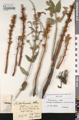
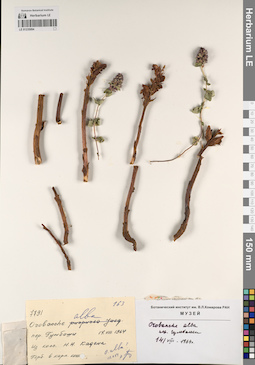
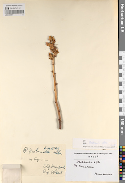
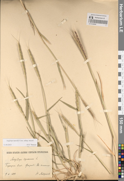
LE 01235103
Groups of specimens: Образцы сектора Кавказа; Соглашение Минобрнауки №075-15-2021-1056Record creation: 2023-04-27, Ivan Tatanov, PhotoScan D2. Part 1.Citation: Specimen LE 01235103 // Virtual herbarium of Komarov Botanical Institute RAS — http://re.herbariumle.ru/01235103
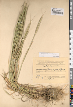
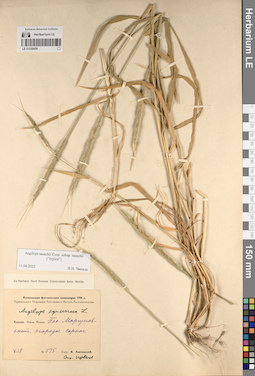
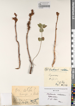
LE 01230963
Groups of specimens: Образцы сектора Средней Азии; Соглашение Минобрнауки №075-15-2021-1056Record creation: 2023-04-27, Ivan Tatanov, PhotoScan D2. Part 2.Citation: Specimen LE 01230963 // Virtual herbarium of Komarov Botanical Institute RAS — http://re.herbariumle.ru/01230963
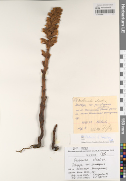
LE 00051155
Groups of specimens: Образцы сектора Средней Азии; Типовые образцы сектора Средней Азии; Соглашение Минобрнауки №075-15-2021-1056Record creation: 2023-04-24, Alexey Grebenjuk, PhotoScan D2. Part 2.Citation: Specimen LE 00051155 // Virtual herbarium of Komarov Botanical Institute RAS — http://re.herbariumle.ru/00051155
LE 01236278
Iris songarica Schrenk
Groups of specimens: Образцы сектора Средней Азии; Соглашение Минобрнауки №075-15-2021-1056Record creation: 2023-04-24, Artyom Leostrin, PhotoScan D2.Citation: Specimen LE 01236278 // Virtual herbarium of Komarov Botanical Institute RAS — http://re.herbariumle.ru/01236278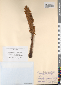
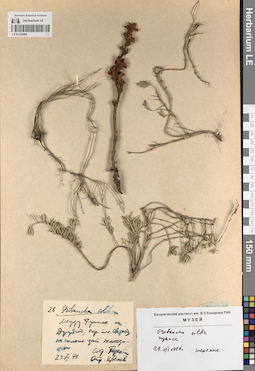
LE 01235102
Groups of specimens: Образцы сектора Кавказа; Соглашение Минобрнауки №075-15-2021-1056Record creation: 2023-04-27, Ivan Tatanov, PhotoScan D2. Part 1.Citation: Specimen LE 01235102 // Virtual herbarium of Komarov Botanical Institute RAS — http://re.herbariumle.ru/01235102
LE 01230962
Groups of specimens: Образцы сектора Средней Азии; Соглашение Минобрнауки №075-15-2021-1056Record creation: 2023-04-27, Ivan Tatanov, PhotoScan D2. Part 2.Citation: Specimen LE 01230962 // Virtual herbarium of Komarov Botanical Institute RAS — http://re.herbariumle.ru/01230962
LE 01235101
Groups of specimens: Образцы сектора Кавказа; Соглашение Минобрнауки №075-15-2021-1056Record creation: 2023-04-27, Ivan Tatanov, PhotoScan D2. Part 1.Citation: Specimen LE 01235101 // Virtual herbarium of Komarov Botanical Institute RAS — http://re.herbariumle.ru/01235101
LE 01230961
Groups of specimens: Образцы сектора Средней Азии; Соглашение Минобрнауки №075-15-2021-1056Record creation: 2023-04-27, Ivan Tatanov, PhotoScan D2. Part 2.Citation: Specimen LE 01230961 // Virtual herbarium of Komarov Botanical Institute RAS — http://re.herbariumle.ru/01230961
LE 01235100
Groups of specimens: Образцы сектора Кавказа; Соглашение Минобрнауки №075-15-2021-1056Record creation: 2023-04-27, Ivan Tatanov, PhotoScan D2. Part 1.Citation: Specimen LE 01235100 // Virtual herbarium of Komarov Botanical Institute RAS — http://re.herbariumle.ru/01235100
LE 01230960
Groups of specimens: Образцы сектора Средней Азии; Соглашение Минобрнауки №075-15-2021-1056Record creation: 2023-04-27, Ivan Tatanov, PhotoScan D2. Part 2.Citation: Specimen LE 01230960 // Virtual herbarium of Komarov Botanical Institute RAS — http://re.herbariumle.ru/01230960
LE 01235099
Groups of specimens: Образцы сектора Кавказа; Соглашение Минобрнауки №075-15-2021-1056Record creation: 2023-04-27, Ivan Tatanov, PhotoScan D2. Part 1.Citation: Specimen LE 01235099 // Virtual herbarium of Komarov Botanical Institute RAS — http://re.herbariumle.ru/01235099
LE 01230959
Groups of specimens: Образцы сектора Средней Азии; Соглашение Минобрнауки №075-15-2021-1056Record creation: 2023-04-27, Ivan Tatanov, PhotoScan D2. Part 2.Citation: Specimen LE 01230959 // Virtual herbarium of Komarov Botanical Institute RAS — http://re.herbariumle.ru/01230959
LE 01235098
Groups of specimens: Образцы сектора Кавказа; Соглашение Минобрнауки №075-15-2021-1056Record creation: 2023-04-27, Ivan Tatanov, PhotoScan D2. Part 1.Citation: Specimen LE 01235098 // Virtual herbarium of Komarov Botanical Institute RAS — http://re.herbariumle.ru/01235098
LE 01230958
Groups of specimens: Образцы сектора Средней Азии; Соглашение Минобрнауки №075-15-2021-1056Record creation: 2023-04-27, Ivan Tatanov, PhotoScan D2. Part 2.Citation: Specimen LE 01230958 // Virtual herbarium of Komarov Botanical Institute RAS — http://re.herbariumle.ru/01230958
LE 01235097
Groups of specimens: Образцы сектора Кавказа; Соглашение Минобрнауки №075-15-2021-1056Record creation: 2023-04-27, Ivan Tatanov, PhotoScan D2. Part 1.Citation: Specimen LE 01235097 // Virtual herbarium of Komarov Botanical Institute RAS — http://re.herbariumle.ru/01235097
LE 01230957
Groups of specimens: Образцы сектора Средней Азии; Соглашение Минобрнауки №075-15-2021-1056Record creation: 2023-04-27, Ivan Tatanov, PhotoScan D2. Part 2.Citation: Specimen LE 01230957 // Virtual herbarium of Komarov Botanical Institute RAS — http://re.herbariumle.ru/01230957
LE 01235096
Groups of specimens: Образцы сектора Кавказа; Соглашение Минобрнауки №075-15-2021-1056Record creation: 2023-04-27, Ivan Tatanov, PhotoScan D2. Part 1.Citation: Specimen LE 01235096 // Virtual herbarium of Komarov Botanical Institute RAS — http://re.herbariumle.ru/01235096
LE 01230956
Groups of specimens: Образцы сектора Средней Азии; Соглашение Минобрнауки №075-15-2021-1056Record creation: 2023-04-27, Ivan Tatanov, PhotoScan D2. Part 2.Citation: Specimen LE 01230956 // Virtual herbarium of Komarov Botanical Institute RAS — http://re.herbariumle.ru/01230956
LE 01235095
Groups of specimens: Образцы сектора Кавказа; Соглашение Минобрнауки №075-15-2021-1056Record creation: 2023-04-27, Ivan Tatanov, PhotoScan D2. Part 1.Citation: Specimen LE 01235095 // Virtual herbarium of Komarov Botanical Institute RAS — http://re.herbariumle.ru/01235095
LE 01230955
Groups of specimens: Образцы сектора Средней Азии; Соглашение Минобрнауки №075-15-2021-1056Record creation: 2023-04-27, Ivan Tatanov, PhotoScan D2. Part 2.Citation: Specimen LE 01230955 // Virtual herbarium of Komarov Botanical Institute RAS — http://re.herbariumle.ru/01230955
LE 01235094
Groups of specimens: Образцы сектора Кавказа; Соглашение Минобрнауки №075-15-2021-1056Record creation: 2023-04-27, Ivan Tatanov, PhotoScan D2. Part 1.Citation: Specimen LE 01235094 // Virtual herbarium of Komarov Botanical Institute RAS — http://re.herbariumle.ru/01235094
LE 01230954
Groups of specimens: Образцы сектора Средней Азии; Соглашение Минобрнауки №075-15-2021-1056Record creation: 2023-04-27, Ivan Tatanov, PhotoScan D2. Part 2.Citation: Specimen LE 01230954 // Virtual herbarium of Komarov Botanical Institute RAS — http://re.herbariumle.ru/01230954
LE 01235093
Groups of specimens: Образцы сектора Кавказа; Соглашение Минобрнауки №075-15-2021-1056Record creation: 2023-04-27, Ivan Tatanov, PhotoScan D2. Part 1.Citation: Specimen LE 01235093 // Virtual herbarium of Komarov Botanical Institute RAS — http://re.herbariumle.ru/01235093
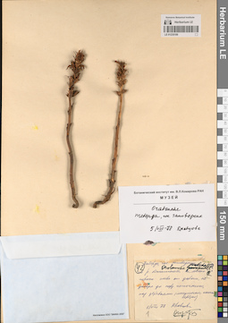
LE 01194080
Anagallis caerulea L. ⟨fl. blue⟩ det. Byalt, Vyacheslav Vyacheslavovich
Collectors: Byalt, Vyacheslav Vyacheslavovich Field collecting number: 783. Collection date: 29.03.2017. Administrative regions: AE - United Arab Emirates. Place of collection: Фуджейра, вади в окрестности г. Мазафи, отрог вади с ручьем.Groups of specimens: Образцы общего сектора; Соглашение Минобрнауки №075-15-2021-1056; Бялт В.В.: Флора ФуджейрыOriginal label text: United Arab Emirates. Emirate of Fujaira, wadi in environs of Masafi, 25°20, 017’ N, 56° 11, 847’ E, 540–600 m alt.: confluence of wadi with water.– ОАЭ, Фуджейра, вади в окрестности г. Мазафи, 25°20, 017’ N, 56° 11, 847’ E, 540–600 м н. ур. м.: отрог вади с ручьем, 29 III 2017, fl., fr., V.V. Byalt 783
LE 01230953
Groups of specimens: Образцы сектора Средней Азии; Соглашение Минобрнауки №075-15-2021-1056Record creation: 2023-04-27, Ivan Tatanov, PhotoScan D2. Part 2.Citation: Specimen LE 01230953 // Virtual herbarium of Komarov Botanical Institute RAS — http://re.herbariumle.ru/01230953
LE 01235092
Groups of specimens: Образцы сектора Кавказа; Соглашение Минобрнауки №075-15-2021-1056Record creation: 2023-04-27, Ivan Tatanov, PhotoScan D2. Part 1.Citation: Specimen LE 01235092 // Virtual herbarium of Komarov Botanical Institute RAS — http://re.herbariumle.ru/01235092
LE 01194079
Anagallis caerulea L. ⟨fl. blue⟩ det. Byalt, Vyacheslav Vyacheslavovich
Collectors: Byalt, Vyacheslav Vyacheslavovich; Korshunov, Mikhail Vladimirovich Field collecting number: 1032. Collection date: 26.03.2018. Administrative regions: AE - United Arab Emirates. Place of collection: Фуджейра, Вади Вурайа Национальный парк, в 8 км северо-западнее г. Хор Факкан, верхняя часть отрогов вади: дно вади, под скалами.Groups of specimens: Образцы общего сектора; Соглашение Минобрнауки №075-15-2021-1056; Бялт В.В.: Флора ФуджейрыOriginal label text: United Arab Emirates. Emirate of Fujaira, Wadi Wurayah National Park, 15-16 km NW from Khor Fakkan, ca. 25°23’ N, 56° 18’ E, upper part of lateral wadi: wadi bottom under rocks.– ОАЭ, Фуджейра, Вади Вурайа Национальный парк, в 8 км к СЗ от г. Хор Факкан, ca. 25°23’ N, 56° 18’ E, верхняя часть отрогов вади: дно вади, под скалами, 26 III 2018, V.V. Byalt, M.V. Korshunov 1032
LE 01230952
Groups of specimens: Образцы сектора Средней Азии; Соглашение Минобрнауки №075-15-2021-1056Record creation: 2023-04-27, Ivan Tatanov, PhotoScan D2. Part 2.Citation: Specimen LE 01230952 // Virtual herbarium of Komarov Botanical Institute RAS — http://re.herbariumle.ru/01230952
LE 01235091
Groups of specimens: Образцы сектора Кавказа; Соглашение Минобрнауки №075-15-2021-1056Record creation: 2023-04-27, Ivan Tatanov, PhotoScan D2. Part 1.Citation: Specimen LE 01235091 // Virtual herbarium of Komarov Botanical Institute RAS — http://re.herbariumle.ru/01235091
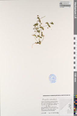
LE 01194078
Anagallis caerulea L. ⟨fl. blue⟩ det. Byalt, Vyacheslav Vyacheslavovich
Collectors: Byalt, Vyacheslav Vyacheslavovich; Korshunov, Mikhail Vladimirovich Field collecting number: 1033. Collection date: 04.04.2018. Administrative regions: AE - United Arab Emirates. Place of collection: Фуджейра, пос. Аль Бидия, сорное вдоль забора сада.Groups of specimens: Образцы общего сектора; Соглашение Минобрнауки №075-15-2021-1056; Бялт В.В.: Флора ФуджейрыOriginal label text: United Arab Emirates. Emirate of Fujaira, village Al Bidiyah, 25°26'13" N, 56°20'2"° Е: weed along fence of garden, fl. blue. – ОАЭ, Фуджейра, посёлок Аль Бидия, 25°26'13" N, 56°20'2"° Е: сорняк вдоль забора сада, 3–4 IV 2018 Leg.: V.V. Byalt, M.V. Korshunov 1033
LE 01230951
Groups of specimens: Образцы сектора Средней Азии; Соглашение Минобрнауки №075-15-2021-1056Record creation: 2023-04-27, Ivan Tatanov, PhotoScan D2. Part 2.Citation: Specimen LE 01230951 // Virtual herbarium of Komarov Botanical Institute RAS — http://re.herbariumle.ru/01230951
LE 01235090
Groups of specimens: Образцы сектора Кавказа; Соглашение Минобрнауки №075-15-2021-1056Record creation: 2023-04-27, Ivan Tatanov, PhotoScan D2. Part 1.Citation: Specimen LE 01235090 // Virtual herbarium of Komarov Botanical Institute RAS — http://re.herbariumle.ru/01235090
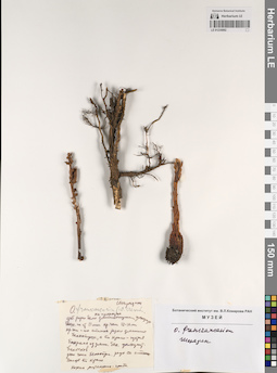
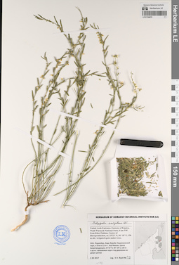
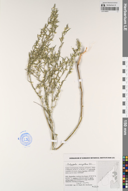
LE 01194077
Polygala erioptera DC. det. Byalt, Vyacheslav Vyacheslavovich
Collectors: Byalt, Vyacheslav Vyacheslavovich; Korshunov, Mikhail Vladimirovich Field collecting number: 1729. Collection date: 25.11.2019. Administrative regions: AE - United Arab Emirates. Place of collection: Фуджейра, пос. Кидфа [point 343]: сорное на поливном газоне в переулке.Groups of specimens: Образцы общего сектора; Соглашение Минобрнауки №075-15-2021-1056; Бялт В.В.: Флора ФуджейрыOriginal label text: United Arab Emirates. Emirate of Fujaira, village Qidfa, 25°17'40.91"N 56°21'28.51"E [point 343]: weed in irrigated grass plot in backstreet. – ОАЭ, Фуджейра, пос. Кидфа, 25°17'40.91"N 56°21'28.51"E [point 343]: сорняк на поливном газоне в переуле, 25 XI 2019, fl., fr., V.V. Byalt & M.V. Korshunov 1729
LE 01230950
Groups of specimens: Образцы сектора Средней Азии; Соглашение Минобрнауки №075-15-2021-1056Record creation: 2023-04-27, Ivan Tatanov, PhotoScan D2. Part 2.Citation: Specimen LE 01230950 // Virtual herbarium of Komarov Botanical Institute RAS — http://re.herbariumle.ru/01230950
LE 01235089
Groups of specimens: Образцы сектора Кавказа; Соглашение Минобрнауки №075-15-2021-1056Record creation: 2023-04-27, Ivan Tatanov, PhotoScan D2. Part 1.Citation: Specimen LE 01235089 // Virtual herbarium of Komarov Botanical Institute RAS — http://re.herbariumle.ru/01235089
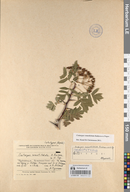
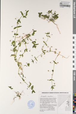
LE 01194076
Polygala erioptera DC. det. Byalt, Vyacheslav Vyacheslavovich
Collectors: Byalt, Vyacheslav Vyacheslavovich Field collecting number: 42. Collection date: 05.12.2017. Administrative regions: AE - United Arab Emirates. Place of collection: Фуджейра, Вади Вурайа Национальный парк, в 8 км северо-западнее г. Хор Факкан, Центр Биорепродукции, орошаемые круги под деревьями во дворе центра, под Acacia.Groups of specimens: Образцы общего сектора; Соглашение Минобрнауки №075-15-2021-1056; Бялт В.В.: Флора ФуджейрыOriginal label text: United Arab Emirates. Emirate of Fujaira, Wadi Wurayah National Park, 8 km NW from Khor Fakkan, Centre of Bioreproduction, ca. 25°23’ N, 56° 18’ E, 150 m alt.: irrigated spots under trees. – ОАЭ, Фуджейра, Вади Вурайа Национальный парк, в 8 км к СЗ от г. Хор Факкан, Центр Биорепродукции, 25°23’ N, 56° 18’ E, 150 м н.ур.м.: орошаемые круги под деревями во дворе центра, под Acacia, 5 XII 2017, fl., fr., V.V. Byalt 42
LE 01230949
Groups of specimens: Образцы сектора Средней Азии; Соглашение Минобрнауки №075-15-2021-1056Record creation: 2023-04-27, Ivan Tatanov, PhotoScan D2. Part 2.Citation: Specimen LE 01230949 // Virtual herbarium of Komarov Botanical Institute RAS — http://re.herbariumle.ru/01230949
LE 01235088
Groups of specimens: Образцы сектора Кавказа; Соглашение Минобрнауки №075-15-2021-1056Record creation: 2023-04-27, Ivan Tatanov, PhotoScan D2. Part 1.Citation: Specimen LE 01235088 // Virtual herbarium of Komarov Botanical Institute RAS — http://re.herbariumle.ru/01235088
LE 01194075
Polygala erioptera DC. det. Byalt, Vyacheslav Vyacheslavovich
Collectors: Byalt, Vyacheslav Vyacheslavovich; Korshunov, Mikhail Vladimirovich Field collecting number: 1034. Collection date: 04.04.2018. Administrative regions: AE - United Arab Emirates. Place of collection: Фуджейра, посёлок Аль Бидия, сорняк вдоль забора сада.Groups of specimens: Образцы общего сектора; Соглашение Минобрнауки №075-15-2021-1056; Бялт В.В.: Флора ФуджейрыOriginal label text: United Arab Emirates. Emirate of Fujaira, village Al Bidiyah, 25°26'13" N, 56°20'2"° Е: weed along fence of garden, wet place. – ОАЭ, Фуджейра, посёлок Аль Бидия, 25°26'13" N, 56°20'2"° Е: сорняк вдоль забора сада, 3–4 IV 2018, fl., fr.,V.V. Byalt, M.V. Korshunov 1034
LE 01230948
Groups of specimens: Образцы сектора Средней Азии; Соглашение Минобрнауки №075-15-2021-1056Record creation: 2023-04-27, Ivan Tatanov, PhotoScan D2. Part 2.Citation: Specimen LE 01230948 // Virtual herbarium of Komarov Botanical Institute RAS — http://re.herbariumle.ru/01230948
LE 01235087
Groups of specimens: Образцы сектора Кавказа; Соглашение Минобрнауки №075-15-2021-1056Record creation: 2023-04-27, Ivan Tatanov, PhotoScan D2. Part 1.Citation: Specimen LE 01235087 // Virtual herbarium of Komarov Botanical Institute RAS — http://re.herbariumle.ru/01235087