View
Add
Copy
Edit
Delete
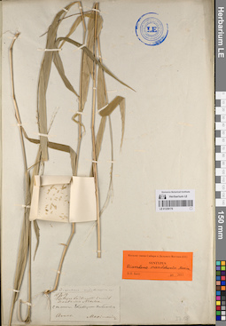
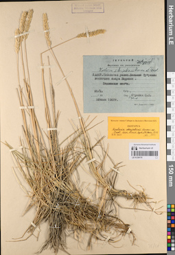
LE 01239178
Groups of specimens: Образцы сектора Сибири и Дальнего Востока России; Типовые образцы сектора Сибири и Дальнего Востока России; Соглашение Минобрнауки №075-15-2021-1056Record creation: 2023-05-25, Marina Yarichina, PhotoScan D2.Citation: Specimen LE 01239178 // Virtual herbarium of Komarov Botanical Institute RAS — http://re.herbariumle.ru/01239178
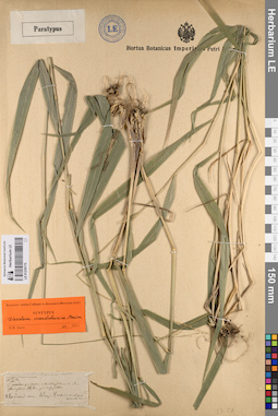
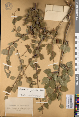
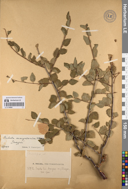
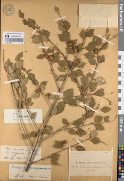
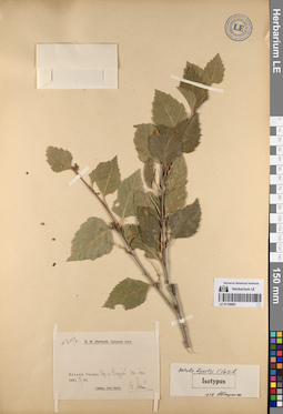
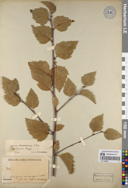
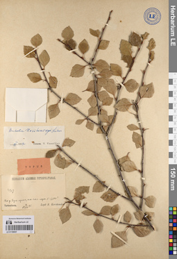
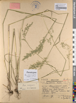
LE 01199072
Betula murgabica V.N. Vassil.
Administrative regions: TJ - Tajikistan. Place of collection: Памир, река Западный Пшарт.Groups of specimens: Образцы сектора Средней Азии; Типовые образцы сектора Средней Азии; Соглашение Минобрнауки №075-15-2021-1056Record creation: 2023-05-24, Mariya Sheludyakova, PhotoScan D2.Citation: Specimen LE 01199072 // Virtual herbarium of Komarov Botanical Institute RAS — http://re.herbariumle.ru/01199072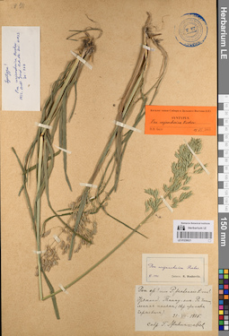
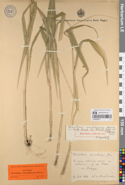
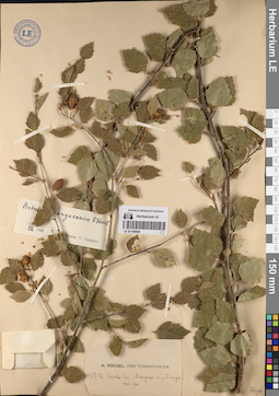
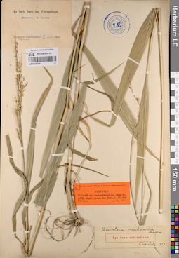
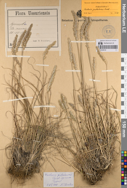
LE 01239021
Groups of specimens: Образцы сектора Сибири и Дальнего Востока России; Типовые образцы сектора Сибири и Дальнего Востока России; Соглашение Минобрнауки №075-15-2021-1056Record creation: 2023-05-24, Marina Yarichina, PhotoScan D2.Citation: Specimen LE 01239021 // Virtual herbarium of Komarov Botanical Institute RAS — http://re.herbariumle.ru/01239021
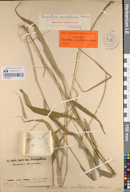
LE 01239177
Groups of specimens: Образцы сектора Сибири и Дальнего Востока России; Типовые образцы сектора Сибири и Дальнего Востока России; Соглашение Минобрнауки №075-15-2021-1056Record creation: 2023-05-25, Marina Yarichina, PhotoScan D2.Citation: Specimen LE 01239177 // Virtual herbarium of Komarov Botanical Institute RAS — http://re.herbariumle.ru/01239177
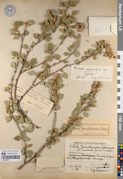
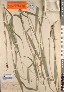
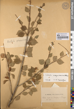
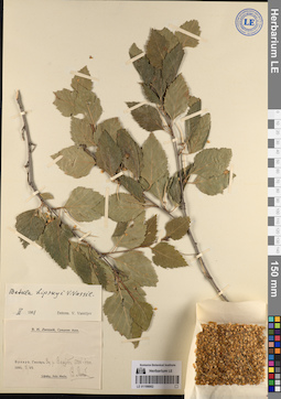
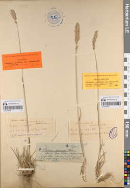
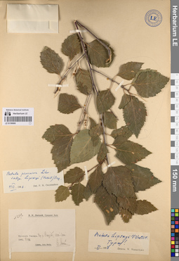
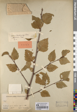
LE 01199071
Betula murgabica V.N. Vassil.
Administrative regions: TJ - Tajikistan. Place of collection: Памир, река Западный Пшарт.Groups of specimens: Образцы сектора Средней Азии; Типовые образцы сектора Средней Азии; Соглашение Минобрнауки №075-15-2021-1056Record creation: 2023-05-24, Mariya Sheludyakova, PhotoScan D2.Citation: Specimen LE 01199071 // Virtual herbarium of Komarov Botanical Institute RAS — http://re.herbariumle.ru/01199071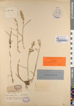
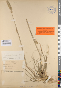
LE 01239020
Groups of specimens: Образцы сектора Сибири и Дальнего Востока России; Типовые образцы сектора Сибири и Дальнего Востока России; Соглашение Минобрнауки №075-15-2021-1056Record creation: 2023-05-24, Marina Yarichina, PhotoScan D2.Citation: Specimen LE 01239020 // Virtual herbarium of Komarov Botanical Institute RAS — http://re.herbariumle.ru/01239020
LE 01239176
Groups of specimens: Образцы сектора Сибири и Дальнего Востока России; Типовые образцы сектора Сибири и Дальнего Востока России; Соглашение Минобрнауки №075-15-2021-1056Record creation: 2023-05-25, Marina Yarichina, PhotoScan D2.Citation: Specimen LE 01239176 // Virtual herbarium of Komarov Botanical Institute RAS — http://re.herbariumle.ru/01239176
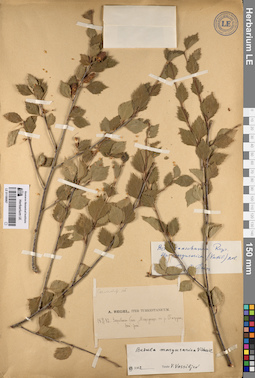
LE 01199070
Betula margusarica V.N. Vassil.
Administrative regions: TJ - Tajikistan. Place of collection: озеро Маргузар.Groups of specimens: Образцы сектора Средней Азии; Типовые образцы сектора Средней Азии; Соглашение Минобрнауки №075-15-2021-1056Record creation: 2023-05-24, Mariya Sheludyakova, PhotoScan D2.Citation: Specimen LE 01199070 // Virtual herbarium of Komarov Botanical Institute RAS — http://re.herbariumle.ru/01199070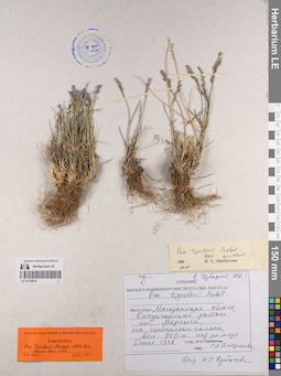
LE 01239019
Groups of specimens: Образцы сектора Сибири и Дальнего Востока России; Типовые образцы сектора Сибири и Дальнего Востока России; Соглашение Минобрнауки №075-15-2021-1056Record creation: 2023-05-24, Marina Yarichina, PhotoScan D2.Citation: Specimen LE 01239019 // Virtual herbarium of Komarov Botanical Institute RAS — http://re.herbariumle.ru/01239019
LE 01239175
Groups of specimens: Образцы сектора Сибири и Дальнего Востока России; Типовые образцы сектора Сибири и Дальнего Востока России; Соглашение Минобрнауки №075-15-2021-1056Record creation: 2023-05-25, Marina Yarichina, PhotoScan D2.Citation: Specimen LE 01239175 // Virtual herbarium of Komarov Botanical Institute RAS — http://re.herbariumle.ru/01239175
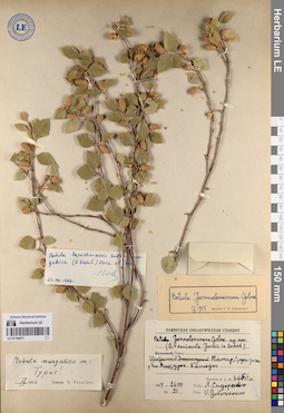
LE 01199069
Betula margusarica V.N. Vassil.
Administrative regions: TJ - Tajikistan. Place of collection: озеро Маргузар.Groups of specimens: Образцы сектора Средней Азии; Типовые образцы сектора Средней Азии; Соглашение Минобрнауки №075-15-2021-1056Record creation: 2023-05-24, Mariya Sheludyakova, PhotoScan D2.Citation: Specimen LE 01199069 // Virtual herbarium of Komarov Botanical Institute RAS — http://re.herbariumle.ru/01199069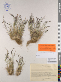
LE 01239018
Groups of specimens: Образцы сектора Сибири и Дальнего Востока России; Типовые образцы сектора Сибири и Дальнего Востока России; Соглашение Минобрнауки №075-15-2021-1056Record creation: 2023-05-24, Marina Yarichina, PhotoScan D2.Citation: Specimen LE 01239018 // Virtual herbarium of Komarov Botanical Institute RAS — http://re.herbariumle.ru/01239018
LE 01239174
Groups of specimens: Образцы сектора Сибири и Дальнего Востока России; Типовые образцы сектора Сибири и Дальнего Востока России; Соглашение Минобрнауки №075-15-2021-1056Record creation: 2023-05-25, Marina Yarichina, PhotoScan D2.Citation: Specimen LE 01239174 // Virtual herbarium of Komarov Botanical Institute RAS — http://re.herbariumle.ru/01239174
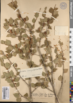
LE 01199068
Betula margusarica V.N. Vassil.
Administrative regions: TJ - Tajikistan. Place of collection: озеро Маргузар.Groups of specimens: Образцы сектора Средней Азии; Типовые образцы сектора Средней Азии; Соглашение Минобрнауки №075-15-2021-1056Record creation: 2023-05-24, Mariya Sheludyakova, PhotoScan D2.Citation: Specimen LE 01199068 // Virtual herbarium of Komarov Botanical Institute RAS — http://re.herbariumle.ru/01199068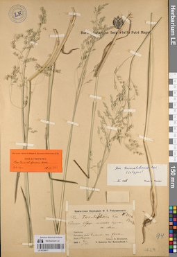
LE 01239017
Groups of specimens: Образцы сектора Сибири и Дальнего Востока России; Типовые образцы сектора Сибири и Дальнего Востока России; Соглашение Минобрнауки №075-15-2021-1056Record creation: 2023-05-24, Marina Yarichina, PhotoScan D2.Citation: Specimen LE 01239017 // Virtual herbarium of Komarov Botanical Institute RAS — http://re.herbariumle.ru/01239017
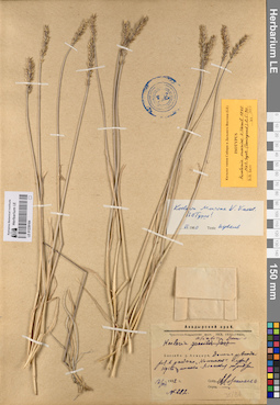
LE 01239173
Groups of specimens: Образцы сектора Сибири и Дальнего Востока России; Типовые образцы сектора Сибири и Дальнего Востока России; Соглашение Минобрнауки №075-15-2021-1056Record creation: 2023-05-25, Marina Yarichina, PhotoScan D2.Citation: Specimen LE 01239173 // Virtual herbarium of Komarov Botanical Institute RAS — http://re.herbariumle.ru/01239173
LE 01199067
Betula margusarica V.N. Vassil.
Administrative regions: TJ - Tajikistan. Place of collection: озеро Маргузар.Groups of specimens: Образцы сектора Средней Азии; Типовые образцы сектора Средней Азии; Соглашение Минобрнауки №075-15-2021-1056Record creation: 2023-05-24, Mariya Sheludyakova, PhotoScan D2.Citation: Specimen LE 01199067 // Virtual herbarium of Komarov Botanical Institute RAS — http://re.herbariumle.ru/01199067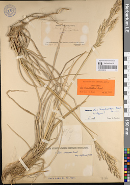
LE 01239016
Groups of specimens: Образцы сектора Сибири и Дальнего Востока России; Типовые образцы сектора Сибири и Дальнего Востока России; Соглашение Минобрнауки №075-15-2021-1056Record creation: 2023-05-24, Marina Yarichina, PhotoScan D2.Citation: Specimen LE 01239016 // Virtual herbarium of Komarov Botanical Institute RAS — http://re.herbariumle.ru/01239016
LE 01239172
Groups of specimens: Образцы сектора Сибири и Дальнего Востока России; Типовые образцы сектора Сибири и Дальнего Востока России; Соглашение Минобрнауки №075-15-2021-1056Record creation: 2023-05-25, Marina Yarichina, PhotoScan D2.Citation: Specimen LE 01239172 // Virtual herbarium of Komarov Botanical Institute RAS — http://re.herbariumle.ru/01239172
LE 01199066
Betula margusarica V.N. Vassil.
Administrative regions: TJ - Tajikistan. Place of collection: озеро Маргузар.Groups of specimens: Образцы сектора Средней Азии; Типовые образцы сектора Средней Азии; Соглашение Минобрнауки №075-15-2021-1056Record creation: 2023-05-24, Mariya Sheludyakova, PhotoScan D2.Citation: Specimen LE 01199066 // Virtual herbarium of Komarov Botanical Institute RAS — http://re.herbariumle.ru/01199066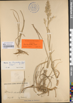
LE 01239015
Groups of specimens: Образцы сектора Сибири и Дальнего Востока России; Типовые образцы сектора Сибири и Дальнего Востока России; Соглашение Минобрнауки №075-15-2021-1056Record creation: 2023-05-24, Marina Yarichina, PhotoScan D2.Citation: Specimen LE 01239015 // Virtual herbarium of Komarov Botanical Institute RAS — http://re.herbariumle.ru/01239015
LE 01239171
Groups of specimens: Образцы сектора Сибири и Дальнего Востока России; Типовые образцы сектора Сибири и Дальнего Востока России; Соглашение Минобрнауки №075-15-2021-1056Record creation: 2023-05-25, Marina Yarichina, PhotoScan D2.Citation: Specimen LE 01239171 // Virtual herbarium of Komarov Botanical Institute RAS — http://re.herbariumle.ru/01239171
LE 01199065
Betula margusarica V.N. Vassil.
Administrative regions: TJ - Tajikistan. Place of collection: озеро Маргузар.Groups of specimens: Образцы сектора Средней Азии; Типовые образцы сектора Средней Азии; Соглашение Минобрнауки №075-15-2021-1056Record creation: 2023-05-24, Mariya Sheludyakova, PhotoScan D2.Citation: Specimen LE 01199065 // Virtual herbarium of Komarov Botanical Institute RAS — http://re.herbariumle.ru/01199065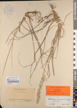
LE 01239014
Groups of specimens: Образцы сектора Сибири и Дальнего Востока России; Типовые образцы сектора Сибири и Дальнего Востока России; Соглашение Минобрнауки №075-15-2021-1056Record creation: 2023-05-24, Marina Yarichina, PhotoScan D2.Citation: Specimen LE 01239014 // Virtual herbarium of Komarov Botanical Institute RAS — http://re.herbariumle.ru/01239014
LE 01239170
Groups of specimens: Образцы сектора Сибири и Дальнего Востока России; Типовые образцы сектора Сибири и Дальнего Востока России; Соглашение Минобрнауки №075-15-2021-1056Record creation: 2023-05-25, Marina Yarichina, PhotoScan D2.Citation: Specimen LE 01239170 // Virtual herbarium of Komarov Botanical Institute RAS — http://re.herbariumle.ru/01239170
LE 01199064
Betula margusarica V.N. Vassil.
Administrative regions: TJ - Tajikistan. Place of collection: озеро Маргузар.Groups of specimens: Образцы сектора Средней Азии; Типовые образцы сектора Средней Азии; Соглашение Минобрнауки №075-15-2021-1056Record creation: 2023-05-24, Mariya Sheludyakova, PhotoScan D2.Citation: Specimen LE 01199064 // Virtual herbarium of Komarov Botanical Institute RAS — http://re.herbariumle.ru/01199064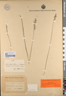
LE 01239013
Groups of specimens: Образцы сектора Сибири и Дальнего Востока России; Типовые образцы сектора Сибири и Дальнего Востока России; Соглашение Минобрнауки №075-15-2021-1056Record creation: 2023-05-24, Marina Yarichina, PhotoScan D2.Citation: Specimen LE 01239013 // Virtual herbarium of Komarov Botanical Institute RAS — http://re.herbariumle.ru/01239013
LE 01239169
Groups of specimens: Образцы сектора Сибири и Дальнего Востока России; Типовые образцы сектора Сибири и Дальнего Востока России; Соглашение Минобрнауки №075-15-2021-1056Record creation: 2023-05-25, Marina Yarichina, PhotoScan D2.Citation: Specimen LE 01239169 // Virtual herbarium of Komarov Botanical Institute RAS — http://re.herbariumle.ru/01239169
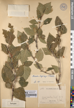
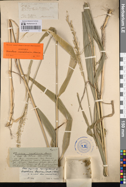
LE 01199063
Betula lipskyi V.N. Vassil.
Administrative regions: TJ - Tajikistan. Place of collection: ущелье реки Варзоб.Groups of specimens: Образцы сектора Средней Азии; Типовые образцы сектора Средней Азии; Соглашение Минобрнауки №075-15-2021-1056Record creation: 2023-05-24, Mariya Sheludyakova, PhotoScan D2.Citation: Specimen LE 01199063 // Virtual herbarium of Komarov Botanical Institute RAS — http://re.herbariumle.ru/01199063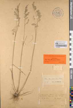
LE 01239012
Groups of specimens: Образцы сектора Сибири и Дальнего Востока России; Типовые образцы сектора Сибири и Дальнего Востока России; Соглашение Минобрнауки №075-15-2021-1056Record creation: 2023-05-24, Marina Yarichina, PhotoScan D2.Citation: Specimen LE 01239012 // Virtual herbarium of Komarov Botanical Institute RAS — http://re.herbariumle.ru/01239012
LE 01239168
Groups of specimens: Образцы сектора Сибири и Дальнего Востока России; Типовые образцы сектора Сибири и Дальнего Востока России; Соглашение Минобрнауки №075-15-2021-1056Record creation: 2023-05-25, Marina Yarichina, PhotoScan D2.Citation: Specimen LE 01239168 // Virtual herbarium of Komarov Botanical Institute RAS — http://re.herbariumle.ru/01239168
LE 01199062
Betula lipskyi V.N. Vassil.
Administrative regions: TJ - Tajikistan. Place of collection: ущелье реки Варзоб.Groups of specimens: Образцы сектора Средней Азии; Типовые образцы сектора Средней Азии; Соглашение Минобрнауки №075-15-2021-1056Record creation: 2023-05-24, Mariya Sheludyakova, PhotoScan D2.Citation: Specimen LE 01199062 // Virtual herbarium of Komarov Botanical Institute RAS — http://re.herbariumle.ru/01199062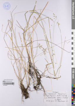
LE 01239011
Groups of specimens: Образцы сектора Сибири и Дальнего Востока России; Типовые образцы сектора Сибири и Дальнего Востока России; Соглашение Минобрнауки №075-15-2021-1056Record creation: 2023-05-24, Marina Yarichina, PhotoScan D2.Citation: Specimen LE 01239011 // Virtual herbarium of Komarov Botanical Institute RAS — http://re.herbariumle.ru/01239011
LE 01239167
Groups of specimens: Образцы сектора Сибири и Дальнего Востока России; Типовые образцы сектора Сибири и Дальнего Востока России; Соглашение Минобрнауки №075-15-2021-1056Record creation: 2023-05-25, Marina Yarichina, PhotoScan D2.Citation: Specimen LE 01239167 // Virtual herbarium of Komarov Botanical Institute RAS — http://re.herbariumle.ru/01239167

LE 01239166
Groups of specimens: Образцы сектора Сибири и Дальнего Востока России; Типовые образцы сектора Сибири и Дальнего Востока России; Соглашение Минобрнауки №075-15-2021-1056Record creation: 2023-05-25, Marina Yarichina, PhotoScan D2.Citation: Specimen LE 01239166 // Virtual herbarium of Komarov Botanical Institute RAS — http://re.herbariumle.ru/01239166
LE 01199061
Betula lipskyi V.N. Vassil.
Administrative regions: TJ - Tajikistan. Place of collection: ущелье реки Варзоб.Groups of specimens: Образцы сектора Средней Азии; Типовые образцы сектора Средней Азии; Соглашение Минобрнауки №075-15-2021-1056Record creation: 2023-05-24, Mariya Sheludyakova, PhotoScan D2.Citation: Specimen LE 01199061 // Virtual herbarium of Komarov Botanical Institute RAS — http://re.herbariumle.ru/01199061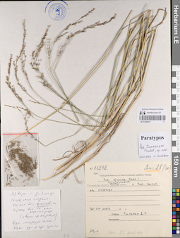
LE 01239010
Groups of specimens: Образцы сектора Сибири и Дальнего Востока России; Типовые образцы сектора Сибири и Дальнего Востока России; Соглашение Минобрнауки №075-15-2021-1056Record creation: 2023-05-24, Marina Yarichina, PhotoScan D2.Citation: Specimen LE 01239010 // Virtual herbarium of Komarov Botanical Institute RAS — http://re.herbariumle.ru/01239010
LE 01239165
Groups of specimens: Образцы сектора Сибири и Дальнего Востока России; Типовые образцы сектора Сибири и Дальнего Востока России; Соглашение Минобрнауки №075-15-2021-1056Record creation: 2023-05-25, Marina Yarichina, PhotoScan D2.Citation: Specimen LE 01239165 // Virtual herbarium of Komarov Botanical Institute RAS — http://re.herbariumle.ru/01239165
LE 01199060
Betula lipskyi V.N. Vassil.
Administrative regions: TJ - Tajikistan. Place of collection: ущелье реки Варзоб.Groups of specimens: Образцы сектора Средней Азии; Типовые образцы сектора Средней Азии; Соглашение Минобрнауки №075-15-2021-1056Record creation: 2023-05-24, Mariya Sheludyakova, PhotoScan D2.Citation: Specimen LE 01199060 // Virtual herbarium of Komarov Botanical Institute RAS — http://re.herbariumle.ru/01199060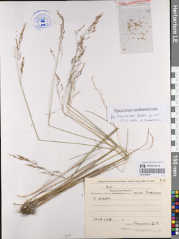
LE 01239009
Groups of specimens: Образцы сектора Сибири и Дальнего Востока России; Типовые образцы сектора Сибири и Дальнего Востока России; Соглашение Минобрнауки №075-15-2021-1056Record creation: 2023-05-24, Marina Yarichina, PhotoScan D2.Citation: Specimen LE 01239009 // Virtual herbarium of Komarov Botanical Institute RAS — http://re.herbariumle.ru/01239009
LE 01239164
Groups of specimens: Образцы сектора Сибири и Дальнего Востока России; Типовые образцы сектора Сибири и Дальнего Востока России; Соглашение Минобрнауки №075-15-2021-1056Record creation: 2023-05-25, Marina Yarichina, PhotoScan D2.Citation: Specimen LE 01239164 // Virtual herbarium of Komarov Botanical Institute RAS — http://re.herbariumle.ru/01239164
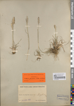
LE 01199059
Betula korshinskyi Litv.
Administrative regions: KG - Kyrgyzstan. Place of collection: река Кугарт.Groups of specimens: Образцы сектора Средней Азии; Типовые образцы сектора Средней Азии; Соглашение Минобрнауки №075-15-2021-1056Record creation: 2023-05-24, Mariya Sheludyakova, PhotoScan D2.Citation: Specimen LE 01199059 // Virtual herbarium of Komarov Botanical Institute RAS — http://re.herbariumle.ru/01199059
LE 01239008
Groups of specimens: Образцы сектора Сибири и Дальнего Востока России; Типовые образцы сектора Сибири и Дальнего Востока России; Соглашение Минобрнауки №075-15-2021-1056Record creation: 2023-05-24, Marina Yarichina, PhotoScan D2.Citation: Specimen LE 01239008 // Virtual herbarium of Komarov Botanical Institute RAS — http://re.herbariumle.ru/01239008
LE 01239163
Groups of specimens: Образцы сектора Сибири и Дальнего Востока России; Типовые образцы сектора Сибири и Дальнего Востока России; Соглашение Минобрнауки №075-15-2021-1056Record creation: 2023-05-25, Marina Yarichina, PhotoScan D2.Citation: Specimen LE 01239163 // Virtual herbarium of Komarov Botanical Institute RAS — http://re.herbariumle.ru/01239163
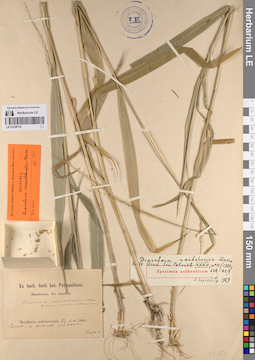
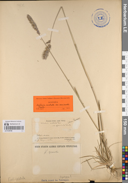
LE 01199058
Betula korshinskyi Litv.
Administrative regions: KG - Kyrgyzstan. Place of collection: река Кугарт.Groups of specimens: Образцы сектора Средней Азии; Типовые образцы сектора Средней Азии; Соглашение Минобрнауки №075-15-2021-1056Record creation: 2023-05-24, Mariya Sheludyakova, PhotoScan D2.Citation: Specimen LE 01199058 // Virtual herbarium of Komarov Botanical Institute RAS — http://re.herbariumle.ru/01199058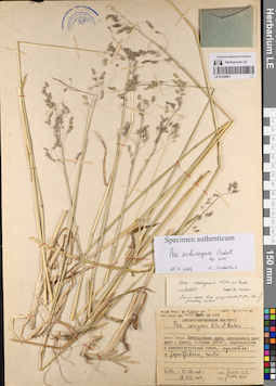
LE 01239007
Groups of specimens: Образцы сектора Сибири и Дальнего Востока России; Типовые образцы сектора Сибири и Дальнего Востока России; Соглашение Минобрнауки №075-15-2021-1056Record creation: 2023-05-24, Marina Yarichina, PhotoScan D2.Citation: Specimen LE 01239007 // Virtual herbarium of Komarov Botanical Institute RAS — http://re.herbariumle.ru/01239007
LE 01239162
Groups of specimens: Образцы сектора Сибири и Дальнего Востока России; Типовые образцы сектора Сибири и Дальнего Востока России; Соглашение Минобрнауки №075-15-2021-1056Record creation: 2023-05-25, Marina Yarichina, PhotoScan D2.Citation: Specimen LE 01239162 // Virtual herbarium of Komarov Botanical Institute RAS — http://re.herbariumle.ru/01239162
LE 01199057
Betula korshinskyi Litv.
Administrative regions: KG - Kyrgyzstan. Place of collection: река Кугарт.Groups of specimens: Образцы сектора Средней Азии; Типовые образцы сектора Средней Азии; Соглашение Минобрнауки №075-15-2021-1056Record creation: 2023-05-24, Mariya Sheludyakova, PhotoScan D2.Citation: Specimen LE 01199057 // Virtual herbarium of Komarov Botanical Institute RAS — http://re.herbariumle.ru/01199057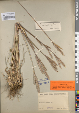
LE 01239161
Groups of specimens: Образцы сектора Сибири и Дальнего Востока России; Типовые образцы сектора Сибири и Дальнего Востока России; Соглашение Минобрнауки №075-15-2021-1056Record creation: 2023-05-25, Marina Yarichina, PhotoScan D2.Citation: Specimen LE 01239161 // Virtual herbarium of Komarov Botanical Institute RAS — http://re.herbariumle.ru/01239161
LE 01239006
Groups of specimens: Образцы сектора Сибири и Дальнего Востока России; Типовые образцы сектора Сибири и Дальнего Востока России; Соглашение Минобрнауки №075-15-2021-1056Record creation: 2023-05-24, Marina Yarichina, PhotoScan D2.Citation: Specimen LE 01239006 // Virtual herbarium of Komarov Botanical Institute RAS — http://re.herbariumle.ru/01239006