View
Add
Copy
Edit
Delete
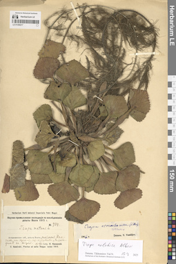
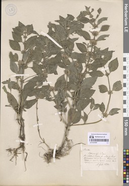
LE 01309217
Trapa natans L. det. Kosinskiy (Kossinski), Konstantin Konstantinovich at 18.08.1915
Additional identifications: Trapa astrachanica (Flerow) N.A. Winter det. Vassiljev, Viktor Nikolayevich at 1946; Trapa colchica Albov det. Tikhomirov, Valery Nikolaevich at 19.03.2025 Collectors: Kosinskiy (Kossinski), Konstantin Konstantinovich Field collecting number: 984. Collection date: 18.08.1915. Administrative regions: RU - Astrakhanskaya Oblast' - Kamyzyakskiy Rayon. Subregion: Образцово-Травинский сельсовет. Топоним: ильмень Дамчик, Астраханская область. Place of collection: дельта реки Волга.Expedition: Научно-промысловая экспедиция по исследованию дельты Волги (1914 -1915)Groups of specimens: Образцы сектора Восточной Европы; Herbarium Horti botanici Imperialis Petri Magni; C. Kossinski. Plantae ad ostia Volgae lectae 1915.; Herbarium of the Komarov Botanical Institute (LE)Life form: hydrophyteOriginal label text:Астраханская губерния, дельта Волги, ильмень Дамчик, на одном из островков, в западине с водой.
Landscape in location of collection: степиHabitat / plant community in location of collecting: на одном из островков ильменя, в западине с водойSubstrate in collecting location: siltCoordinates (geographic position): 45° 47′ 43.94″ N, 47° 53′ 47.29″ ERecord creation: 2025-06-03, Denis Melnikov, PhotoScan D2Citation: Specimen LE 01309217 // Virtual herbarium of Komarov Botanical Institute RAS — http://re.herbariumle.ru/01309217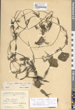
LE 01309216
Trapa natans L. det. Nekrasova, Vera Leontievna at 23.08.1928
Additional identifications: Trapa astrachanica (Flerow) N.A. Winter det. Vassiljev, Viktor Nikolayevich at 1946; Trapa colchica Albov det. Tikhomirov, Valery Nikolaevich at 19.03.2025; Trapa maeotica Woronow det. Tikhomirov, Valery Nikolaevich at 19.03.2025 Collectors: Nekrasova, Vera Leontievna Field collecting number: 84. Collection date: 23.08.1928. Administrative regions: RU - Astrakhanskaya Oblast' - Kamyzyakskiy Rayon. Subregion: Образцово-Травинский сельсовет. Топоним: Волжский заповедник (Астраханский биосферный заповедник). Place of collection: дельта реки Волга.Expedition: В. Л. Некрасова: Экспедиция Главного Ботанического Сада в новые районы хлопководства 1928 г. ()Groups of specimens: Образцы сектора Восточной Европы; Herbarium of the Komarov Botanical Institute (LE)Life form: hydrophyteObject features: в воде, во множествеOriginal label text:Астраханская губерния Волжский заповедник
Landscape in location of collection: степиHabitat / plant community in location of collecting: прибрежная зона рекиSubstrate in collecting location: siltCoordinates (geographic position): 45° 47′ 44.74″ N, 47° 53′ 31.4″ ERecord creation: 2025-06-03, Denis Melnikov, PhotoScan D2Citation: Specimen LE 01309216 // Virtual herbarium of Komarov Botanical Institute RAS — http://re.herbariumle.ru/01309216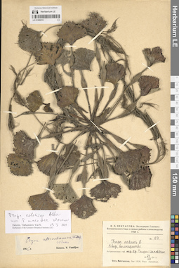
LE 01309215
Trapa natans L. det. Nekrasova, Vera Leontievna at 23.08.1928
Additional identifications: Trapa astrachanica (Flerow) N.A. Winter det. Vassiljev, Viktor Nikolayevich at 1946; Trapa colchica Albov det. Tikhomirov, Valery Nikolaevich at 19.03.2025; Trapa maeotica Woronow det. Tikhomirov, Valery Nikolaevich at 19.03.2025 Collectors: Nekrasova, Vera Leontievna Field collecting number: 84. Collection date: 23.08.1928. Administrative regions: RU - Astrakhanskaya Oblast' - Kamyzyakskiy Rayon. Subregion: Образцово-Травинский сельсовет. Топоним: Волжский заповедник (Астраханский биосферный заповедник). Place of collection: дельта реки Волга.Expedition: В. Л. Некрасова: Экспедиция Главного Ботанического Сада в новые районы хлопководства 1928 г. ()Groups of specimens: Образцы сектора Восточной Европы; Herbarium of the Komarov Botanical Institute (LE)Life form: hydrophyteObject features: в воде, во множествеOriginal label text:Астраханская губерния Волжский заповедник
Landscape in location of collection: степиHabitat / plant community in location of collecting: прибрежная зона рекиSubstrate in collecting location: siltCoordinates (geographic position): 45° 47′ 44.74″ N, 47° 53′ 31.4″ ERecord creation: 2025-06-03, Denis Melnikov, PhotoScan D2Citation: Specimen LE 01309215 // Virtual herbarium of Komarov Botanical Institute RAS — http://re.herbariumle.ru/01309215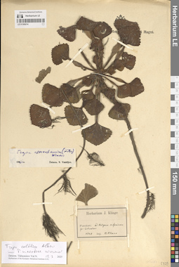
LE 01309214
Trapa colchica Albov det. Tikhomirov, Valery Nikolaevich at 19.03.2025
Additional identifications: Trapa maeotica Woronow det. Tikhomirov, Valery Nikolaevich at 19.03.2025 Collectors: Claus, Karl Ernst Collection date: 1848. Administrative regions: RU - Astrakhanskaya Oblast' - Gorod Astrakhan'. Топоним: Astrachan (г. Астрахань). Place of collection: низовья реки Волга, возле Астрахани.Groups of specimens: Образцы сектора Восточной Европы; Herbarium J. Klinge; Herbarium of the Komarov Botanical Institute (LE)Life form: hydrophyteOriginal label text:Fundort: ad Wolgam inferiorem prope Astrachan
Landscape in location of collection: степиHabitat / plant community in location of collecting: прибрежная зона рекиSubstrate in collecting location: siltCoordinates (geographic position): 46° 20′ 51.41″ N, 48° 1′ 48.64″ ERecord creation: 2025-06-03, Denis Melnikov, PhotoScan D2Citation: Specimen LE 01309214 // Virtual herbarium of Komarov Botanical Institute RAS — http://re.herbariumle.ru/01309214
LE 01309213
Trapa natans L. det. illegible at 1849
Additional identifications: Trapa caucasica auct. det. Flerow, Alexandr Fedorovich at 02.03.1914; Trapa colchica Albov det. Tikhomirov, Valery Nikolaevich at 19.03.2025; Trapa maeotica Woronow det. Tikhomirov, Valery Nikolaevich at 19.03.2025 Collectors: illegible Field collecting number: 4. Collection date: 1849. Administrative regions: RU - Astrakhanskaya Oblast' - Gorod Astrakhan'. Топоним: Astrachan (г. Астрахань). Place of collection: возле Астрахани.Groups of specimens: Образцы сектора Восточной Европы; Herbarium Academiae Scientiarum Petropol.; Herbarium of the Komarov Botanical Institute (LE)Life form: hydrophyteOriginal label text:Prope Astrachan
Landscape in location of collection: степиHabitat / plant community in location of collecting: прибрежная зона рекиSubstrate in collecting location: siltCoordinates (geographic position): 46° 20′ 51.41″ N, 48° 1′ 48.64″ ERecord creation: 2025-06-03, Denis Melnikov, PhotoScan D2Citation: Specimen LE 01309213 // Virtual herbarium of Komarov Botanical Institute RAS — http://re.herbariumle.ru/01309213
LE 01309212
Trapa natans L. det. Krymskaya, M. at 24.07.1936
Additional identifications: Trapa astrachanica (Flerow) N.A. Winter det. Vassiljev, Viktor Nikolayevich at 1946; Trapa colchica Albov det. Tikhomirov, Valery Nikolaevich at 19.03.2025; Trapa maeotica Woronow det. Tikhomirov, Valery Nikolaevich at 19.03.2025 Collectors: Krymskaya, M. Collection date: 24.07.1936. Administrative regions: RU - Astrakhanskaya Oblast' - Volodarskiy Rayon. Subregion: Калининский сельсовет. Топоним: Обжоровская коса, Астраханская область. Place of collection: дельта реки Волга, Астраханский государственный заповедник.Groups of specimens: Образцы сектора Восточной Европы; Herbarium Universitatis saratoviensis; Herbarium of the Komarov Botanical Institute (LE)Life form: hydrophyteOriginal label text:Дельта Волги. Астраханский государственный заповедник. Обжоровская коса
Landscape in location of collection: степиHabitat / plant community in location of collecting: прибрежная зона рекиSubstrate in collecting location: siltCoordinates (geographic position): 46° 18′ 16.6″ N, 49° 1′ 51.92″ ERecord creation: 2025-06-03, Denis Melnikov, PhotoScan D2Citation: Specimen LE 01309212 // Virtual herbarium of Komarov Botanical Institute RAS — http://re.herbariumle.ru/01309212
LE 01309211
Trapa caucasica auct. det. Flerow, Alexandr Fedorovich at 03.03.1914
Additional identifications: Trapa astrachanica (Flerow) N.A. Winter det. Vassiljev, Viktor Nikolayevich at 1946; Trapa colchica Albov det. Tikhomirov, Valery Nikolaevich at 19.03.2025 Collectors: Korshinsky, Sergei Ivanovitsch Administrative regions: RU - Astrakhanskaya Oblast' - Narimanovskiy Rayon. Subregion: Старокучергановский сельсовет. Топоним: река Большая Яблонка, Астраханская область (река Яблонька). Place of collection: дельта реки Волга.Groups of specimens: Образцы сектора Восточной Европы; Herbarium Academiae Scientiarum Petropol.; Флора дельты реки Волги; Herbarium of the Komarov Botanical Institute (LE)Life form: hydrophyteOriginal label text:На реке Большой Яблонке.
Landscape in location of collection: степиHabitat / plant community in location of collecting: прибрежная зона рекиSubstrate in collecting location: siltCoordinates (geographic position): 46° 15′ 51.83″ N, 47° 51′ 57.22″ ERecord creation: 2025-06-03, Denis Melnikov, PhotoScan D2Citation: Specimen LE 01309211 // Virtual herbarium of Komarov Botanical Institute RAS — http://re.herbariumle.ru/01309211
LE 01309210
Trapa astrachanica (Flerow) N.A. Winter det. Vassiljev, Viktor Nikolayevich at 08.1964
Additional identifications: Trapa astrachanica (Flerow) N.A. Winter det. Vassiljev, Viktor Nikolayevich at 05.1971; Trapa colchica Albov det. Tikhomirov, Valery Nikolaevich at 19.03.2025; Trapa maeotica Woronow det. Tikhomirov, Valery Nikolaevich at 19.03.2025 Collectors: Valjtsova, O. V. Collection date: 08.1964. Administrative regions: RU - Astrakhanskaya Oblast' - Gorod Astrakhan'. Топоним: Astrachan (г. Астрахань). Place of collection: Астрахань.Groups of specimens: Образцы сектора Восточной Европы; Гербарий Ботанического Института Академии наук СССР; Herbarium Instituti Botanici Academiae Sc. URSS; Herbarium of the Komarov Botanical Institute (LE)Life form: hydrophyteOriginal label text:Астрахань
Landscape in location of collection: степиHabitat / plant community in location of collecting: прибрежная зона рекиSubstrate in collecting location: siltRecord creation: 2025-06-03, Denis Melnikov, PhotoScan D2Citation: Specimen LE 01309210 // Virtual herbarium of Komarov Botanical Institute RAS — http://re.herbariumle.ru/01309210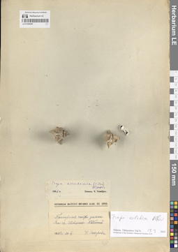
LE 01309209
Trapa astrachanica (Flerow) N.A. Winter det. Vassiljev, Viktor Nikolayevich at 1946
Additional identifications: Trapa colchica Albov det. Tikhomirov, Valery Nikolaevich at 19.03.2025 Collectors: Sakharova, N. Collection date: 30.09.1925. Administrative regions: RU - Astrakhanskaya Oblast' - Kamyzyakskiy Rayon. Subregion: Караулинский сельсовет. Топоним: остров (ильмень) Кабаний, Астраханская область. Place of collection: приморская часть дельты реки Волга.Groups of specimens: Образцы сектора Восточной Европы; Herbarium Instituti Botanici Acad. Sc. URSS; Herbarium of the Komarov Botanical Institute (LE)Life form: hydrophyteOriginal label text:Приморская часть дельты Волги. Ильмень Кабаний
Landscape in location of collection: степиHabitat / plant community in location of collecting: прибрежная зона рекиSubstrate in collecting location: siltCoordinates (geographic position): 45° 51′ 19″ N, 48° 13′ 32.32″ ERecord creation: 2025-06-03, Denis Melnikov, PhotoScan D2Citation: Specimen LE 01309209 // Virtual herbarium of Komarov Botanical Institute RAS — http://re.herbariumle.ru/01309209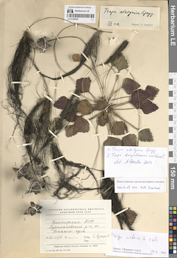
LE 01309208
Trapa alatyrica Sprygin ex V.N. Vassil. det. Czkalov, Andrey Vjacheslavovich at 2024
Additional identifications: Trapa borysthenica V.N. Vassil. det. Czkalov, Andrey Vjacheslavovich at 2024; Trapa natans L. ⟮s. str.⟯ det. Tikhomirov, Valery Nikolaevich at 19.03.2025 Collectors: Kucherova, E. Collection date: 21.08.1955. Administrative regions: RU - Bashkortostan - Buzdyakskiy Rayon. Subregion: Канлы-Туркеевский сельсовет. Топоним: озеро Улканлы-Куль (озеро Канлы-Куль). Place of collection: озеро Канлы-Куль.Groups of specimens: Образцы сектора Восточной Европы; Гербарий Ботанического Института Академии наук СССР; Herbarium Instituti Botanici Academiae Sc. URSS; Herbarium of the Komarov Botanical Institute (LE)Life form: hydrophyteOriginal label text:Башкирская АССР Нуримановский район, озеро Улканлы-куль.
Landscape in location of collection: лесостепиHabitat / plant community in location of collecting: прибрежная зона озераSubstrate in collecting location: siltCoordinates (geographic position): 54° 23′ 58.97″ N, 54° 24′ 37.67″ EComment: Взяты образцы для молекулярного анализа. 15.09.2016 / Xue Jianhua
Record creation: 2025-06-03, Denis Melnikov, PhotoScan D2Citation: Specimen LE 01309208 // Virtual herbarium of Komarov Botanical Institute RAS — http://re.herbariumle.ru/01309208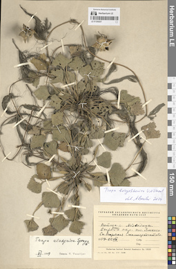
LE 01309207
Trapa alatyrica Sprygin ex V.N. Vassil. det. Vassiljev, Viktor Nikolayevich at 06.1959
Additional identifications: Trapa borysthenica V.N. Vassil. det. Czkalov, Andrey Vjacheslavovich at 2024 Collection date: 22.08.1957. Administrative regions: RU - Volgogradskaya Oblast' - Danilovskiy Rayon. Subregion: Островское сельское поселение. Топоним: озеро Ямное, Волгоградская область. Place of collection: пойма реки Медведица, в окрестностях станицы Островская.Groups of specimens: Образцы сектора Восточной Европы; Гербарий Ботанического Института Академии наук СССР; Herbarium Instituti Botanici Academiae Sc. URSSLife form: hydrophyteOriginal label text:Пойма реки Медведицы. Озеро Ямное в окрестностях поселка Ямного Станица Островская Сталинградской области
Landscape in location of collection: степиHabitat / plant community in location of collecting: прибрежная зона озераSubstrate in collecting location: siltCoordinates (geographic position): 50° 26′ 56.89″ N, 44° 24′ 7.54″ ERecord creation: 2025-06-03, Denis Melnikov, PhotoScan D2Citation: Specimen LE 01309207 // Virtual herbarium of Komarov Botanical Institute RAS — http://re.herbariumle.ru/01309207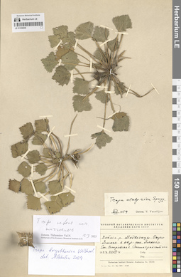
LE 01309206
Trapa alatyrica Sprygin ex V.N. Vassil. det. Vassiljev, Viktor Nikolayevich at 08.1959
Additional identifications: Trapa borysthenica V.N. Vassil. det. Czkalov, Andrey Vjacheslavovich at 2024; Trapa natans L. ⟮s. l.⟯ det. Tikhomirov, Valery Nikolaevich at 19.03.2025 Collection date: 22.08.1957. Administrative regions: RU - Volgogradskaya Oblast' - Danilovskiy Rayon. Subregion: Островское сельское поселение. Топоним: озеро Ямное, Волгоградская область. Place of collection: пойма реки Медведица, в окрестностях станицы Островская.Groups of specimens: Образцы сектора Восточной Европы; Гербарий Ботанического Института Академии наук СССР; Herbarium Instituti Botanici Academiae Sc. URSS; Herbarium of the Komarov Botanical Institute (LE)Life form: hydrophyteOriginal label text:Пойма реки Медведицы. Озеро Ямное в окрестностях поселка Ямного Станица Островская Сталинградской области
Landscape in location of collection: степиHabitat / plant community in location of collecting: прибрежная зона озераSubstrate in collecting location: siltCoordinates (geographic position): 50° 26′ 56.89″ N, 44° 24′ 7.54″ ERecord creation: 2025-06-03, Denis Melnikov, PhotoScan D2Citation: Specimen LE 01309206 // Virtual herbarium of Komarov Botanical Institute RAS — http://re.herbariumle.ru/01309206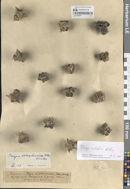
LE 01309205
Trapa astrachanica (Flerow) N.A. Winter
Additional identifications: Trapa astrachanica (Flerow) N.A. Winter det. Vassiljev, Viktor Nikolayevich at 09.1958; Trapa colchica Albov det. Tikhomirov, Valery Nikolaevich at 19.03.2025 Administrative regions: RU - Astrakhanskaya Oblast' - Volodarskiy Rayon. Subregion: Калининский сельсовет. Топоним: култук Гранушин, Астраханская область (ильмень култук Григорша). Place of collection: дельта реки Волга.Groups of specimens: Образцы сектора Восточной Европы; Herbarium of the Komarov Botanical Institute (LE)Life form: hydrophyteObject features: комплексOriginal label text:Из култука Гранушина в дельте Волги (45°50' северной широты и 47°53' восточной долготы)
Landscape in location of collection: степиHabitat / plant community in location of collecting: прибрежная зона рекиSubstrate in collecting location: siltCoordinates (geographic position): 46° 24′ 35.1″ N, 48° 59′ 8.45″ ERecord creation: 2025-06-03, Denis Melnikov, PhotoScan D2Citation: Specimen LE 01309205 // Virtual herbarium of Komarov Botanical Institute RAS — http://re.herbariumle.ru/01309205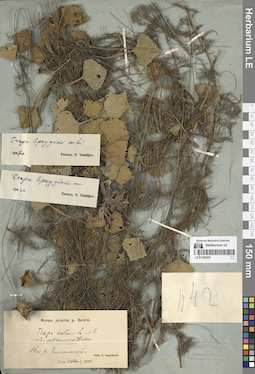
LE 01309204
Trapa spryginii V.N. Vassil. det. Vassiljev, Viktor Nikolayevich at 1946
Additional identifications: Trapa spryginii V.N. Vassil. det. Vassiljev, Viktor Nikolayevich at 1947; Trapa natans L. ⟮s. l.⟯ det. Tzvelev, Nikolai Nikolaievich at 1990 Collectors: Korshinsky, Sergei Ivanovitsch Field collecting number: 42. Administrative regions: RU - Astrakhanskaya Oblast' - Ikryaninskiy Rayon. Subregion: Ново-Булгаринский сельсовет. Топоним: река Чилимная, Икрянинский район, Астраханская область. Place of collection: дельта реки Волга.Groups of specimens: Образцы сектора Восточной Европы; Флора дельты реки ВолгиLife form: hydrophyteOriginal label text:На реке Чилимной.
Landscape in location of collection: степиHabitat / plant community in location of collecting: прибрежная зона рекиSubstrate in collecting location: siltCoordinates (geographic position): 46° 8′ 47.93″ N, 47° 51′ 38.07″ ERecord creation: 2025-06-03, Denis Melnikov, PhotoScan D2Citation: Specimen LE 01309204 // Virtual herbarium of Komarov Botanical Institute RAS — http://re.herbariumle.ru/01309204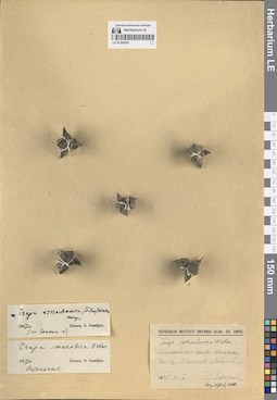
LE 01309203
Trapa astrachanica (Flerow) N.A. Winter det. Vassiljev, Viktor Nikolayevich at 1947
Additional identifications: Trapa astrachanica (Flerow) N.A. Winter det. Tzvelev, Nikolai Nikolaievich at 1990 Collectors: Sakharova, N. Collection date: 30.09.1925. Administrative regions: RU - Astrakhanskaya Oblast' - Kamyzyakskiy Rayon. Subregion: Караулинский сельсовет. Топоним: остров (ильмень) Кабаний, Астраханская область. Place of collection: приморская часть дельты реки Волга.Groups of specimens: Образцы сектора Восточной Европы; Herbarium Instituti Botanici Acad. Sc. URSSLife form: hydrophyteOriginal label text:Приморская часть дельты Волги. Ильмень Кабаний
Landscape in location of collection: степиHabitat / plant community in location of collecting: прибрежная зона рекиSubstrate in collecting location: siltCoordinates (geographic position): 45° 51′ 23.02″ N, 48° 13′ 1.25″ ERecord creation: 2025-06-03, Denis Melnikov, PhotoScan D2Citation: Specimen LE 01309203 // Virtual herbarium of Komarov Botanical Institute RAS — http://re.herbariumle.ru/01309203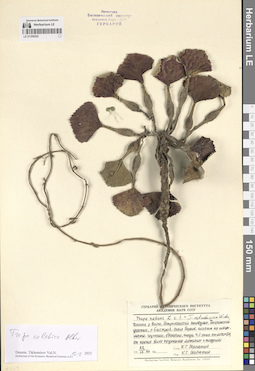
LE 01309202
Trapa natans L. det. Maliutin K. G. at 22.09.1966
Additional identifications: Trapa colchica Albov det. Tikhomirov, Valery Nikolaevich at 19.03.2025 Collectors: Maliutin K. G. Collection date: 22.09.1966. Administrative regions: RU - Astrakhanskaya Oblast' - Kamyzyakskiy Rayon. Subregion: Николо-Комаровский сельсовет. Топоним: река (протока) Быстрая, Астраханская область. Place of collection: Дамчинский участок, Астраханский заповедник, дельта реки Волга.Groups of specimens: Образцы сектора Восточной Европы; Гербарий Ботанического Института Академии наук СССР; Herbarium of the Komarov Botanical Institute (LE)Life form: hydrophyteObject features: плавает на поверхности, группами, одиночно, плоды 4, 5 - рогие, отличаются от прочих более крупными листьями и плодамиOriginal label text:Дельта реки Волги, Астраханский заповедник, Дамчинский участок, река Быстрая, около берегов, плавает на поверхности, группами, одиночно, плоды 4, 5 - рогие, отличаются от прочих более крупными листьями и плодами.
Landscape in location of collection: степиHabitat / plant community in location of collecting: прибрежная зона рекиSubstrate in collecting location: siltCoordinates (geographic position): 46° 10′ 44.4″ N, 47° 56′ 10.79″ ERecord creation: 2025-06-03, Denis Melnikov, PhotoScan D2Citation: Specimen LE 01309202 // Virtual herbarium of Komarov Botanical Institute RAS — http://re.herbariumle.ru/01309202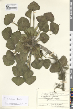
LE 01309201
Trapa natans L. det. Artemenko, V. I. at 04.10.1973
Additional identifications: Trapa colchica Albov det. Tikhomirov, Valery Nikolaevich at 19.03.2025 Collectors: Ekzertsev, V. Collection date: 04.10.1973. Administrative regions: RU - Astrakhanskaya Oblast'. Subregion: Красноярский муниципальный округ. Топоним: Ильменский подстепной район. Place of collection: дельта реки Волга.Groups of specimens: Образцы сектора Восточной Европы; Гербарий Института биологии внутренних вод; Herbarium of the Komarov Botanical Institute (LE)Life form: hydrophyteOriginal label text:Астраханская область, Ильменский район, Дельта реки Волги
Landscape in location of collection: степиHabitat / plant community in location of collecting: прибрежная зона рекиSubstrate in collecting location: siltCoordinates (geographic position): 46° 26′ 13.75″ N, 48° 15′ 0.27″ ERecord creation: 2025-06-03, Denis Melnikov, PhotoScan D2Citation: Specimen LE 01309201 // Virtual herbarium of Komarov Botanical Institute RAS — http://re.herbariumle.ru/01309201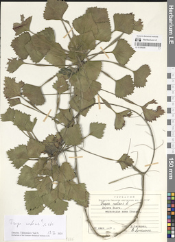
LE 01309200
Trapa natans L. det. Artemenko, V. I. at 29.07.1979
Additional identifications: Trapa natans L. ⟮s. str.⟯ det. Tikhomirov, Valery Nikolaevich at 19.03.2025 Collectors: Lisitsyna Ludmila Ivanovna Collection date: 29.07.1979. Administrative regions: RU - Astrakhanskaya Oblast' - Volodarskiy Rayon. Subregion: Маковский сельсовет. Топоним: Огневка (предположительно, Пятая Огневка). Place of collection: ниже Огневки.Groups of specimens: Образцы сектора Восточной Европы; Гербарий Института биологии внутренних вод; Herbarium of the Komarov Botanical Institute (LE)Life form: hydrophyteOriginal label text:Дельта Волги, мелководье ниже Огневки.
Landscape in location of collection: степиHabitat / plant community in location of collecting: мелководьеSubstrate in collecting location: siltCoordinates (geographic position): 45° 58′ 15.38″ N, 48° 46′ 32.65″ ERecord creation: 2025-06-03, Denis Melnikov, PhotoScan D2Citation: Specimen LE 01309200 // Virtual herbarium of Komarov Botanical Institute RAS — http://re.herbariumle.ru/01309200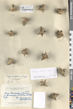
LE 01309199
Isotype of Trapa alatyrica Sprygin ex V.N. Vassil. det. Vassiljev, Viktor Nikolayevich at 09.1958
Additional identifications: Trapa natans L. ⟮s. str.⟯ det. Tikhomirov, Valery Nikolaevich at 19.03.2025 Collectors: Sprygin, Ivan Ivanovich Administrative regions: RU - Respublika Mordoviya - Ichalkovskiy Rayon. Subregion: Смольненское сельское поселение. Топоним: озеро Песчаное, Мордовия. Place of collection: в долине реки Алатырь.Groups of specimens: Образцы сектора Восточной Европы; Гербарий Ботанического Института Академии наук СССР; Herbarium Instituti Botanici Academiae Sc. URSS; Herbarium of the Komarov Botanical Institute (LE)Life form: hydrophyteOriginal label text:Озеро Песчаное в долине реки Алатыря (54°53' северной широты и 45°27' восточной долготы)
Landscape in location of collection: граница хвойно-широколиственных (смешанных) лесов (подтайги) и лесостепейHabitat / plant community in location of collecting: прибрежная зона озераSubstrate in collecting location: siltCoordinates (geographic position): 54° 44′ 15.51″ N, 45° 28′ 22.27″ ERecord creation: 2025-06-03, Denis Melnikov, PhotoScan D2Citation: Specimen LE 01309199 // Virtual herbarium of Komarov Botanical Institute RAS — http://re.herbariumle.ru/01309199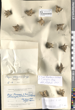
LE 01309198
Isotype of Trapa alatyrica Sprygin ex V.N. Vassil. det. Vassiljev, Viktor Nikolayevich at 09.1958
Additional identifications: Trapa borysthenica V.N. Vassil. det. Czkalov, Andrey Vjacheslavovich at 2024; Trapa alatyrica Sprygin ex V.N. Vassil. det. Czkalov, Andrey Vjacheslavovich at 2024; Trapa natans L. det. Tikhomirov, Valery Nikolaevich at 19.03.2025 Collectors: Sprygin, Ivan Ivanovich Administrative regions: RU - Respublika Mordoviya - Ichalkovskiy Rayon. Subregion: Смольненское сельское поселение. Топоним: озеро Песчаное, Мордовия. Place of collection: в долине реки Алатырь.Groups of specimens: Образцы сектора Восточной Европы; Гербарий Ботанического Института Академии наук СССР; Herbarium Instituti Botanici Academiae Sc. URSS; Herbarium of the Komarov Botanical Institute (LE)Life form: hydrophyteOriginal label text:Озеро Песчаное в долине реки Алатыря (54°53' северной широты и 45°27' восточной долготы)
Landscape in location of collection: граница хвойно-широколиственных (смешанных) лесов (подтайги) и лесостепейHabitat / plant community in location of collecting: прибрежная зона озераSubstrate in collecting location: siltCoordinates (geographic position): 54° 44′ 15.51″ N, 45° 28′ 22.27″ ERecord creation: 2025-06-03, Denis Melnikov, PhotoScan D2Citation: Specimen LE 01309198 // Virtual herbarium of Komarov Botanical Institute RAS — http://re.herbariumle.ru/01309198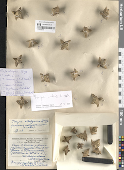
LE 01309197
Trapa natans L. ⟮s. str.⟯ det. Tikhomirov, Valery Nikolaevich at 19.03.2025
Additional identifications: Trapa alatyrica Sprygin ex V.N. Vassil. ⟨имеются недоразвитые плоды⟩ det. Vassiljev, Viktor Nikolayevich at 09.1958; Trapa alatyrica Sprygin ex V.N. Vassil. det. Tzvelev, Nikolai Nikolaievich at 1990; Trapa alatyrica Sprygin ex V.N. Vassil. det. Czkalov, Andrey Vjacheslavovich at 2024; Trapa natans L. ⟮s. str.⟯ det. Czkalov, Andrey Vjacheslavovich at 2024; Trapa conocarpa (F. Aresch.) Flerow det. Czkalov, Andrey Vjacheslavovich at 2024; Trapa okensis V.N. Vassil. det. Czkalov, Andrey Vjacheslavovich at 2024; Trapa borysthenica V.N. Vassil. det. Czkalov, Andrey Vjacheslavovich at 2024; Trapa cruciata (Gluck) V.N. Vassil. det. Czkalov, Andrey Vjacheslavovich at 2024 Collectors: Sprygin, Ivan Ivanovich Administrative regions: RU - Respublika Mordoviya - Temnikovskiy Rayon. Subregion: Темниковское городское поселение. Топоним: город Темников, Мордовия. Place of collection: озеро в долине реки Мокша (правый приток реки Ока), в окрестностях города Темникова.Groups of specimens: Образцы сектора Восточной Европы; Herbarium Instituti Botanici Academiae Sc. URSS; Herbarium of the Komarov Botanical Institute (LE)Life form: hydrophyteOriginal label text:Озеро в долине реки Мокши (правый приток Оки) в окрестностях города Темникова (54°38' северной широты и 43°10' восточной долготы)
Landscape in location of collection: граница хвойно-широколиственных (смешанных) лесов (подтайги) и лесостепейHabitat / plant community in location of collecting: прибрежная зона озераSubstrate in collecting location: siltCoordinates (geographic position): 54° 37′ 50.22″ N, 43° 13′ 9.14″ ERecord creation: 2025-06-03, Denis Melnikov, PhotoScan D2Citation: Specimen LE 01309197 // Virtual herbarium of Komarov Botanical Institute RAS — http://re.herbariumle.ru/01309197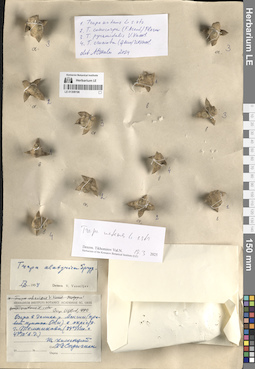
LE 01309196
Trapa natans L. ⟮s. str.⟯ det. Tikhomirov, Valery Nikolaevich at 19.03.2025
Additional identifications: Trapa alatyrica Sprygin ex V.N. Vassil. det. Vassiljev, Viktor Nikolayevich at 09.1958 Collectors: Sprygin, Ivan Ivanovich Administrative regions: RU - Respublika Mordoviya - Temnikovskiy Rayon. Subregion: Темниковское городское поселение. Топоним: город Темников, Мордовия. Place of collection: озеро в долине реки Мокша (правый приток реки Ока), в окрестностях города Темникова.Groups of specimens: Образцы сектора Восточной Европы; Herbarium Instituti Botanici Academiae Sc. URSS; Herbarium of the Komarov Botanical Institute (LE)Life form: hydrophyteOriginal label text:Озеро в долине реки Мокши (правый приток Оки) в окрестностях города Темникова (54°38' северной широты и 43°10' восточной долготы)
Landscape in location of collection: граница хвойно-широколиственных (смешанных) лесов (подтайги) и лесостепейHabitat / plant community in location of collecting: прибрежная зона озераSubstrate in collecting location: siltCoordinates (geographic position): 54° 37′ 50.22″ N, 43° 13′ 9.14″ ERecord creation: 2025-06-03, Denis Melnikov, PhotoScan D2Citation: Specimen LE 01309196 // Virtual herbarium of Komarov Botanical Institute RAS — http://re.herbariumle.ru/01309196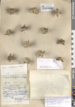
LE 01309195
Trapa natans L. ⟮s. str.⟯ det. Tikhomirov, Valery Nikolaevich at 19.03.2025
Additional identifications: Trapa alatyrica Sprygin ex V.N. Vassil. det. Vassiljev, Viktor Nikolayevich at 09.1958; Trapa alatyrica Sprygin ex V.N. Vassil. det. Tzvelev, Nikolai Nikolaievich at 1990; Trapa borysthenica V.N. Vassil. det. Czkalov, Andrey Vjacheslavovich at 2024; Trapa natans L. ⟮s. str.⟯ det. Czkalov, Andrey Vjacheslavovich at 2024; Trapa okensis V.N. Vassil. det. Czkalov, Andrey Vjacheslavovich at 2024; Trapa borysthenica V.N. Vassil. ⟨гибрид с Trapa flerovii⟩ det. Czkalov, Andrey Vjacheslavovich at 2024 Collectors: Sprygin, Ivan Ivanovich Administrative regions: RU - Respublika Mordoviya - Temnikovskiy Rayon. Subregion: Темниковское городское поселение. Топоним: город Темников, Мордовия. Place of collection: озеро в долине реки Мокша (правый приток реки Ока), в окрестностях города Темникова.Groups of specimens: Образцы сектора Восточной Европы; Herbarium Instituti Botanici Academiae Sc. URSS; Herbarium of the Komarov Botanical Institute (LE)Life form: hydrophyteOriginal label text:Озеро в долине реки Мокши (правый приток Оки) в окрестностях города Темникова (54°38' северной широты и 43°10' восточной долготы)
Landscape in location of collection: граница хвойно-широколиственных (смешанных) лесов (подтайги) и лесостепейHabitat / plant community in location of collecting: прибрежная зона озераSubstrate in collecting location: siltCoordinates (geographic position): 54° 37′ 50.22″ N, 43° 13′ 9.14″ ERecord creation: 2025-06-03, Denis Melnikov, PhotoScan D2Citation: Specimen LE 01309195 // Virtual herbarium of Komarov Botanical Institute RAS — http://re.herbariumle.ru/01309195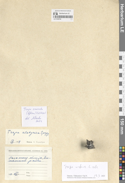
LE 01309194
Trapa natans L. ⟮s. str.⟯ det. Tikhomirov, Valery Nikolaevich at 19.03.2025
Additional identifications: Trapa alatyrica Sprygin ex V.N. Vassil. det. Vassiljev, Viktor Nikolayevich at 09.1958; Trapa cruciata (Gluck) V.N. Vassil. det. Czkalov, Andrey Vjacheslavovich at 2024 Collection date: 08.1951. Administrative regions: RU - Ryazanskaya Oblast'. Subregion: Касимовский муниципальный округ. Топоним: Елатомский район (упразднен в 1963 году, частично входит в Касимовский муниципальный округ Рязанской области). Groups of specimens: Образцы сектора Восточной Европы; Herbarium Instituti Botanici Academiae Sc. URSS; Herbarium of the Komarov Botanical Institute (LE)Life form: hydrophyteOriginal label text:Рязанская область, Елатомский район.
Habitat / plant community in location of collecting: прибрежная зона водоемаSubstrate in collecting location: siltCoordinates (geographic position): 54° 57′ 58.13″ N, 41° 45′ 5.18″ ERecord creation: 2025-06-03, Denis Melnikov, PhotoScan D2Citation: Specimen LE 01309194 // Virtual herbarium of Komarov Botanical Institute RAS — http://re.herbariumle.ru/01309194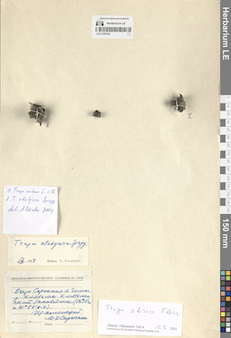
LE 01309193
Trapa sibirica Flerow det. Tikhomirov, Valery Nikolaevich at 19.03.2025
Additional identifications: Trapa alatyrica Sprygin ex V.N. Vassil. det. Vassiljev, V. at 09.1958; Trapa alatyrica Sprygin ex V.N. Vassil. det. Czkalov, Andrey Vjacheslavovich at 2024; Trapa natans L. ⟮s. str.⟯ det. Czkalov, Andrey Vjacheslavovich at 2024 Collectors: Sprygin, Ivan Ivanovich Administrative regions: RU - Ivanovskaya Oblast' - Yuzhskiy Rayon. Subregion: Холуйское сельское поселение. Топоним: озеро Сорокино, Ивановская область. Place of collection: Клязьменский заказник, долина реки Клязьма.Groups of specimens: Образцы сектора Восточной Европы; Herbarium Instituti Botanici Academiae Sc. URSS; Herbarium of the Komarov Botanical Institute (LE)Life form: hydrophyteOriginal label text:Озеро Сорокино в долине реки Клязьмы. Клязьменский заповедник. (56°32' северной широты и 41°54' восточной долготы).
Landscape in location of collection: подтайга (смешанные леса) с пойменными дубравамиHabitat / plant community in location of collecting: прибрежная зона озераSubstrate in collecting location: siltCoordinates (geographic position): 56° 31′ 29.37″ N, 41° 50′ 51.26″ ERecord creation: 2025-06-03, Denis Melnikov, PhotoScan D2Citation: Specimen LE 01309193 // Virtual herbarium of Komarov Botanical Institute RAS — http://re.herbariumle.ru/01309193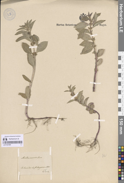
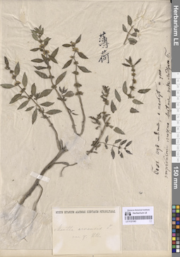
LE 01321094
Mentha arvensis L. det. Turczaninow, Nicolai Stepanowisch
Collectors: Turczaninow, Nicolai Stepanowisch Collection date: 1833. Administrative regions: RU - Irkutskaya Oblast'. Groups of specimens: Образцы сектора Сибири и Дальнего Востока РоссииOriginal label text:In humidis ad fl. Angaram
Record creation: 2025-06-03 Marina Yarichina, PhotoScan D2Citation: Specimen LE 01321094 // Virtual herbarium of Komarov Botanical Institute RAS — http://re.herbariumle.ru/01321094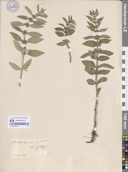
LE 01321093
Mentha arvensis L. det. Turczaninow, Nicolai Stepanowisch
Collectors: Turczaninow, Nicolai Stepanowisch Collection date: 1828. Administrative regions: RU - Irkutskaya Oblast'. Groups of specimens: Образцы сектора Сибири и Дальнего Востока РоссииOriginal label text:Ircutia
Record creation: 2025-06-03 Marina Yarichina, PhotoScan D2Citation: Specimen LE 01321093 // Virtual herbarium of Komarov Botanical Institute RAS — http://re.herbariumle.ru/01321093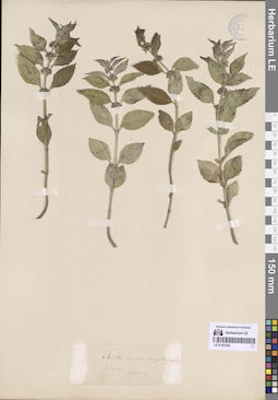
LE 01321092
Mentha arvensis L.
Collectors: Stubendorff, Yuliy Ivanovich Administrative regions: RU - Irkutskaya Oblast' - Kirenskiy Rayon. Groups of specimens: Образцы сектора Сибири и Дальнего Востока РоссииOriginal label text:Kirensk
Record creation: 2025-06-03 Marina Yarichina, PhotoScan D2Citation: Specimen LE 01321092 // Virtual herbarium of Komarov Botanical Institute RAS — http://re.herbariumle.ru/01321092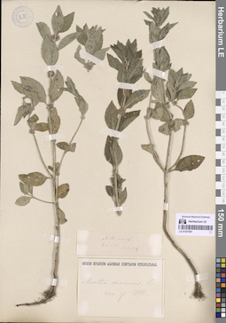
LE 01321091
Mentha arvensis L.
Collectors: Stubendorff, Yuliy Ivanovich Administrative regions: RU - Irkutskaya Oblast' - Kirenskiy Rayon. Groups of specimens: Образцы сектора Сибири и Дальнего Востока РоссииOriginal label text:Kirensk
Record creation: 2025-06-03 Marina Yarichina, PhotoScan D2Citation: Specimen LE 01321091 // Virtual herbarium of Komarov Botanical Institute RAS — http://re.herbariumle.ru/01321091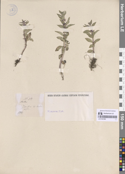
LE 01321090
Mentha arvensis L.
Field collecting number: 314. Collection date: 1881. Administrative regions: RU - Irkutskaya Oblast' - Irkutskiy Rayon. Groups of specimens: Образцы сектора Сибири и Дальнего Востока РоссииOriginal label text:Irkutia ad Uschakofkam.
Record creation: 2025-06-03 Marina Yarichina, PhotoScan D2Citation: Specimen LE 01321090 // Virtual herbarium of Komarov Botanical Institute RAS — http://re.herbariumle.ru/01321090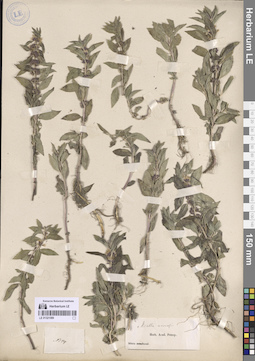
LE 01321089
Mentha arvensis L.
Administrative regions: RU - Irkutskaya Oblast'. Groups of specimens: Образцы сектора Сибири и Дальнего Востока РоссииOriginal label text:Sibiria Baical
Record creation: 2025-06-03 Marina Yarichina, PhotoScan D2Citation: Specimen LE 01321089 // Virtual herbarium of Komarov Botanical Institute RAS — http://re.herbariumle.ru/01321089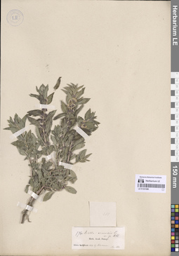
LE 01321088
Mentha arvensis L.
Collectors: Fuhrmann, Michail Collection date: 1852. Administrative regions: RU - Irkutskaya Oblast'. Groups of specimens: Образцы сектора Сибири и Дальнего Востока РоссииOriginal label text:Sibiria Baical.
Record creation: 2025-06-03 Marina Yarichina, PhotoScan D2Citation: Specimen LE 01321088 // Virtual herbarium of Komarov Botanical Institute RAS — http://re.herbariumle.ru/01321088Acc. 1858
LE 01321087
Mentha arvensis L.
Collectors: Augustinowicz, Foma Matveevich Collection date: 15.07.1874. Administrative regions: RU - Irkutskaya Oblast' - Ust'-Kutskiy Rayon. Place of collection: окрестности пос. Орлинга.Groups of specimens: Образцы сектора Сибири и Дальнего Востока РоссииOriginal label text:Иркутской губернии. На левом берегу р. Лены близ Орлинской почтовой станции Киренского округа. Между Urtica urens. Почва черноземно-глинистая.
Coordinates (geographic position): 56° 3′ 0.66″ N, 105° 51′ 33.02″ E ±1000 mRecord creation: 2025-06-03 Marina Yarichina, PhotoScan D2Citation: Specimen LE 01321087 // Virtual herbarium of Komarov Botanical Institute RAS — http://re.herbariumle.ru/01321087
LE 01321086
Mentha arvensis L.
Collectors: Augustinowicz, Foma Matveevich Collection date: 14.06.1874. Administrative regions: RU - Irkutskaya Oblast' - Zhigalovskiy Rayon. Groups of specimens: Образцы сектора Сибири и Дальнего Востока РоссииOriginal label text:Иркутской губернии. На краю правого берега р. Лены у подножья глинистой горы между Грузновской и Закаменской почтовыми станциями Киренского уезда
Coordinates (geographic position): 55° 18′ 23.07″ N, 105° 26′ 38.32″ E ±5000 mComment: Расстояние между станциями Грузновская и Закаменская составляло 20 верст (Почтовая карта Азиатской России, 1871 г.)
Record creation: 2025-06-03 Marina Yarichina, PhotoScan D2Citation: Specimen LE 01321086 // Virtual herbarium of Komarov Botanical Institute RAS — http://re.herbariumle.ru/01321086
LE 01321085
Mentha arvensis L.
Collectors: Augustinowicz, Foma Matveevich Collection date: 14.06.1876. Administrative regions: RU - Irkutskaya Oblast' - Zhigalovskiy Rayon. Groups of specimens: Образцы сектора Сибири и Дальнего Востока РоссииOriginal label text:Иркутской губернии. На краю правого берега р. Лены у подножья глинистой горы между Грузновской и Закаменской почтовыми станциями Киренского уезда.
Coordinates (geographic position): 55° 18′ 23.07″ N, 105° 26′ 38.32″ E ±5000 mComment: Расстояние между станциями Грузновская и Закаменская составляло 20 верст (Почтовая карта Азиатской России, 1871 г.)
Record creation: 2025-06-03 Marina Yarichina, PhotoScan D2Citation: Specimen LE 01321085 // Virtual herbarium of Komarov Botanical Institute RAS — http://re.herbariumle.ru/01321085
LE 01321084
Mentha arvensis L.
Collectors: Haupt, Wilhelm Field collecting number: 249. Administrative regions: RU - Irkutskaya Oblast'. Groups of specimens: Образцы сектора Сибири и Дальнего Востока РоссииOriginal label text:Irkutia.
Record creation: 2025-06-03 Marina Yarichina, PhotoScan D2Citation: Specimen LE 01321084 // Virtual herbarium of Komarov Botanical Institute RAS — http://re.herbariumle.ru/01321084Herb. Fischer
LE 01321083
Mentha arvensis L.
Collectors: Steller, Georg Wilhelm Administrative regions: RU - Irkutskaya Oblast'. Place of collection: Скорее всего - окрестности Иркутска.Groups of specimens: Образцы сектора Сибири и Дальнего Востока РоссииRecord creation: 2025-06-03 Marina Yarichina, PhotoScan D2Citation: Specimen LE 01321083 // Virtual herbarium of Komarov Botanical Institute RAS — http://re.herbariumle.ru/01321083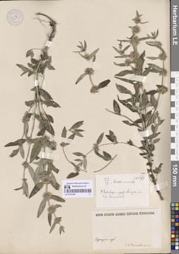
LE 01321082
Mentha arvensis L.
Collectors: Vitkovskij, Nikolai Ivanovich Field collecting number: 281. Collection date: 19.07. Administrative regions: RU - Krasnoyarskiy Kray - Kezhemskiy Rayon. Groups of specimens: Образцы сектора Сибири и Дальнего Востока РоссииOriginal label text:р. Чадобец - приток Ангары близ дер. Заледеевой.
Coordinates (geographic position): 58° 40′ 37.54″ N, 98° 47′ 35.72″ E ±1000 mRecord creation: 2025-06-03 Marina Yarichina, PhotoScan D2Citation: Specimen LE 01321082 // Virtual herbarium of Komarov Botanical Institute RAS — http://re.herbariumle.ru/01321082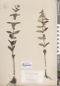
LE 01321081
Mentha arvensis L.
Collectors: Vitkovskij, Nikolai Ivanovich Collection date: 1891. Administrative regions: RU - Irkutskaya Oblast' - Irkutskiy Rayon. Groups of specimens: Образцы сектора Сибири и Дальнего Востока РоссииOriginal label text:Окрестности г. Иркутска
Record creation: 2025-06-03 Marina Yarichina, PhotoScan D2Citation: Specimen LE 01321081 // Virtual herbarium of Komarov Botanical Institute RAS — http://re.herbariumle.ru/01321081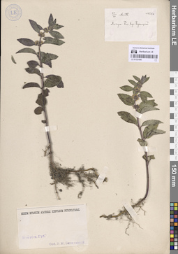
LE 01321080
Mentha arvensis L.
Collectors: Vitkovskij, Nikolai Ivanovich Field collecting number: 286. Collection date: 10.07. Administrative regions: RU - Irkutskaya Oblast'. Groups of specimens: Образцы сектора Сибири и Дальнего Востока РоссииOriginal label text:Ангара, близ дер. Черноцкой
Record creation: 2025-06-03 Marina Yarichina, PhotoScan D2Citation: Specimen LE 01321080 // Virtual herbarium of Komarov Botanical Institute RAS — http://re.herbariumle.ru/01321080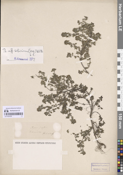
LE 01321079
Thymus sibiricus (Serg.) Klokov & Des.-Shost. det. Menitsky, Yuri Leonardovich
Additional identifications: Thymus serpyllum L. Collectors: Stubendorff, Yuliy Ivanovich Administrative regions: RU - Respublika Sakha (Yakutiya) - Olyokminsky District. Groups of specimens: Образцы сектора Сибири и Дальнего Востока РоссииOriginal label text:Olekminsk
Coordinates (geographic position): 60° 22′ 40.77″ N, 120° 23′ 33.68″ E ±2000 mRecord creation: 2025-06-03 Marina Yarichina, PhotoScan D2Citation: Specimen LE 01321079 // Virtual herbarium of Komarov Botanical Institute RAS — http://re.herbariumle.ru/01321079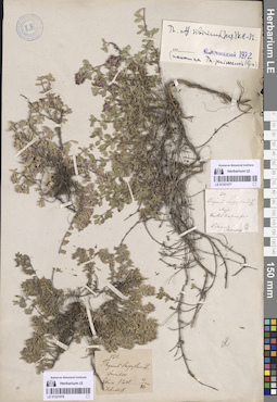
LE 01321077
Thymus sibiricus (Serg.) Klokov & Des.-Shost. det. Menitsky, Yuri Leonardovich
Additional identifications: Thymus serpyllum L. Collectors: Stubendorff, Yuliy Ivanovich Field collecting number: 24. Collection date: 26.06. Administrative regions: RU - Respublika Sakha (Yakutiya). Groups of specimens: Образцы сектора Сибири и Дальнего Востока РоссииRecord creation: 2025-06-03 Marina Yarichina, PhotoScan D2Citation: Specimen LE 01321077 // Virtual herbarium of Komarov Botanical Institute RAS — http://re.herbariumle.ru/01321077
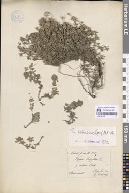
LE 01321078
Thymus sibiricus (Serg.) Klokov & Des.-Shost. det. Menitsky, Yuri Leonardovich
Additional identifications: Thymus serpyllum L. Collectors: Stubendorff, Yuliy Ivanovich Field collecting number: 121. Collection date: 16.06. Administrative regions: RU - Respublika Sakha (Yakutiya). Groups of specimens: Образцы сектора Сибири и Дальнего Востока РоссииOriginal label text:Irkutsk
Record creation: 2025-06-03 Marina Yarichina, PhotoScan D2Citation: Specimen LE 01321078 // Virtual herbarium of Komarov Botanical Institute RAS — http://re.herbariumle.ru/01321078или Jakutsk
LE 01321076
Thymus sibiricus (Serg.) Klokov & Des.-Shost. det. Menitsky, Yuri Leonardovich
Additional identifications: Thymus serpyllum L. Collectors: Stubendorff, Yuliy Ivanovich Administrative regions: RU - Respublika Sakha (Yakutiya). Groups of specimens: Образцы сектора Сибири и Дальнего Востока РоссииOriginal label text:Sibiria orient. prope Jakutiam
Record creation: 2025-06-03 Marina Yarichina, PhotoScan D2Citation: Specimen LE 01321076 // Virtual herbarium of Komarov Botanical Institute RAS — http://re.herbariumle.ru/01321076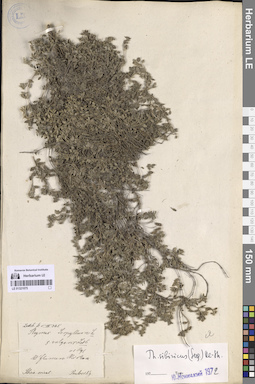
LE 01321075
Thymus sibiricus (Serg.) Klokov & Des.-Shost. det. Menitsky, Yuri Leonardovich
Additional identifications: Thymus serpyllum L. det. Regel, Eduard August von Collectors: Pavlowsky, Aleksander Petrovich Administrative regions: RU - Respublika Sakha (Yakutiya). Groups of specimens: Образцы сектора Сибири и Дальнего Востока РоссииOriginal label text:Sibiria orient. Ad flumen Mirkan
Record creation: 2025-06-03 Marina Yarichina, PhotoScan D2Citation: Specimen LE 01321075 // Virtual herbarium of Komarov Botanical Institute RAS — http://re.herbariumle.ru/01321075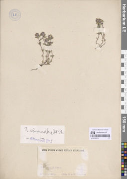
LE 01321074
Thymus sibiricus (Serg.) Klokov & Des.-Shost. det. Menitsky, Yuri Leonardovich
Collectors: Czerski, Jan Stanisław Franciszek; Cherskaya, Marpha Pavlovna Collection date: 15.06.1891. Administrative regions: RU - Respublika Sakha (Yakutiya) - Bulunsky District. Groups of specimens: Образцы сектора Сибири и Дальнего Востока РоссииOriginal label text:Восточная Сибирь, р. Лена
Record creation: 2025-06-03 Marina Yarichina, PhotoScan D2Citation: Specimen LE 01321074 // Virtual herbarium of Komarov Botanical Institute RAS — http://re.herbariumle.ru/01321074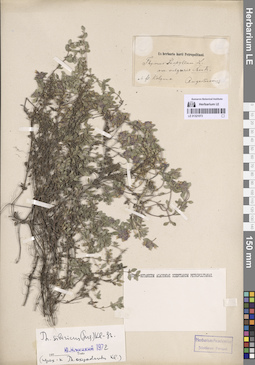
LE 01321073
Thymus sibiricus (Serg.) Klokov & Des.-Shost. det. Menitsky, Yuri Leonardovich
Additional identifications: Thymus serpyllum L. Collectors: Augustinowicz, Foma Matveevich Collection date: 1876. Administrative regions: RU - Respublika Sakha (Yakutiya) - Srednekolymsky District. Groups of specimens: Образцы сектора Сибири и Дальнего Востока РоссииOriginal label text:Ad fl. Kolyma
Record creation: 2025-06-03 Marina Yarichina, PhotoScan D2Citation: Specimen LE 01321073 // Virtual herbarium of Komarov Botanical Institute RAS — http://re.herbariumle.ru/01321073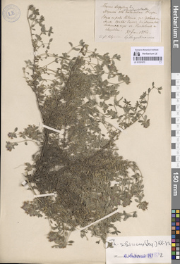
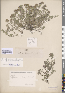
LE 01321072
Thymus sibiricus (Serg.) Klokov & Des.-Shost. det. Menitsky, Yuri Leonardovich
Additional identifications: Thymus serpyllum L. Collectors: Augustinowicz, Foma Matveevich Collection date: 27.06.1876. Administrative regions: RU - Respublika Sakha (Yakutiya) - Srednekolymsky District. Groups of specimens: Образцы сектора Сибири и Дальнего Востока РоссииOriginal label text:Ad fl. Kolyma.
Coordinates (geographic position): 67° 6′ 32.31″ N, 153° 7′ 14.62″ E ±200 mRecord creation: 2025-06-03 Marina Yarichina, PhotoScan D2Citation: Specimen LE 01321072 // Virtual herbarium of Komarov Botanical Institute RAS — http://re.herbariumle.ru/01321072Якутской области Колымского округа. Вверх по реке Колыме за Средне Колымск, правый берег: на склонах скалистых гор между Гороховским и Слёзовским [острова на Колыме].
LE 01321071
Thymus sibiricus (Serg.) Klokov & Des.-Shost. det. Menitsky, Yuri Leonardovich
Collectors: Baderke Collection date: 16.06.1876. Administrative regions: RU - Irkutskaya Oblast' - Kachugskiy Rayon. Groups of specimens: Образцы сектора Сибири и Дальнего Востока РоссииOriginal label text:Anga dem 16/6 76
Record creation: 2025-06-03 Marina Yarichina, PhotoScan D2Citation: Specimen LE 01321071 // Virtual herbarium of Komarov Botanical Institute RAS — http://re.herbariumle.ru/01321071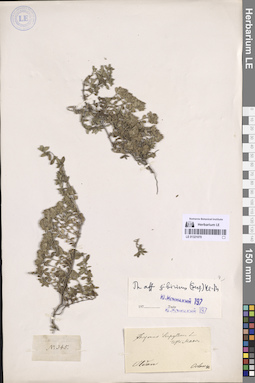
LE 01321070
Thymus sibiricus (Serg.) Klokov & Des.-Shost. det. Menitsky, Yuri Leonardovich
Additional identifications: Thymus serpyllum L. Collectors: Orlow, Dmitry Ivanovich Field collecting number: 345. Collection date: 1848. Administrative regions: RU - Respublika Sakha (Yakutiya) - Aldanskiy Rayon. Groups of specimens: Образцы сектора Сибири и Дальнего Востока РоссииOriginal label text:Aldan
Record creation: 2025-06-03 Marina Yarichina, PhotoScan D2Citation: Specimen LE 01321070 // Virtual herbarium of Komarov Botanical Institute RAS — http://re.herbariumle.ru/01321070