View
Add
Copy
Edit
Delete
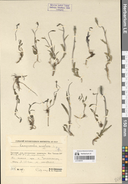
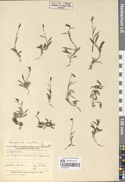
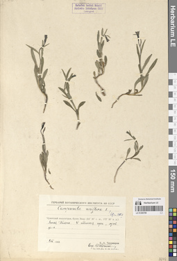
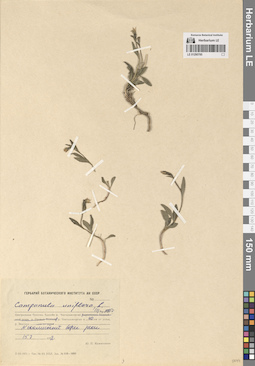
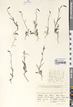
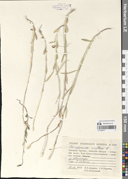
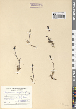
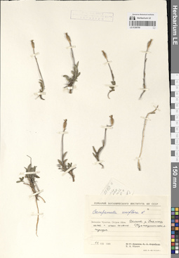
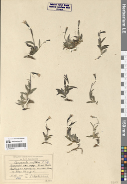
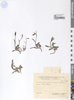
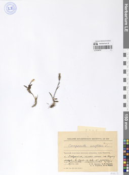
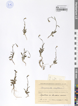
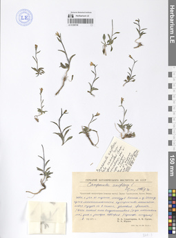
LE 01290797
Campanula uniflora L.
Collectors: Gavrilyuk, Victor Antonovich Collection date: 25.07.1957. Administrative regions: RU - Chukotskiy Avtonomnyy Okrug. Groups of specimens: Образцы сектора Сибири и Дальнего Востока РоссииOriginal label text:Чукотский полуостров, юго-восточная оконечность. Мыс Чаплина (64° 24' с. ш., 172° 12' з. д.), окрестности. На склонах горы к Чаплинскому озеру, 1,5-2 км от последнего.
Coordinates (geographic position): 64° 26′ 11.48″ N, 172° 26′ 50.86″ WComment: 25.VII.1957
В. А. Гаврилюк
Chukotka Peninsula, southeastern end. Cape Chaplin (64° 24' N, 172° 12' W), surroundings. On the slopes of the mountain to Lake Chaplinskoye, 1.5-2 km from the latter.
Record creation: 2024-08-04, Daria Yudova, PhotoScan D2.Citation: Specimen LE 01290797 // Virtual herbarium of Komarov Botanical Institute RAS — http://re.herbariumle.ru/0129079725.07.1957
Coll. V. A. Gavrilyuk
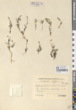
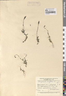
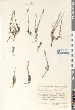
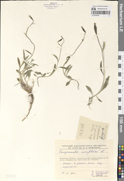
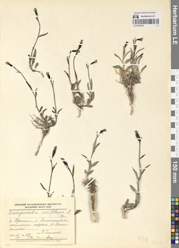
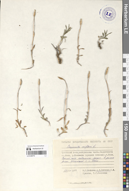
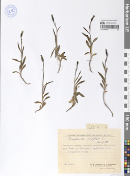
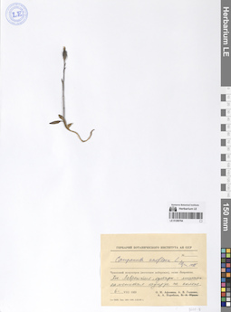
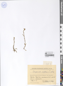
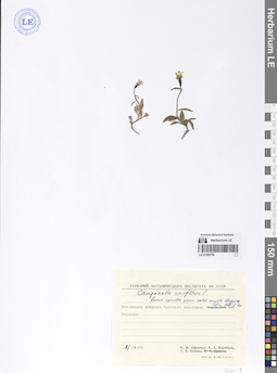
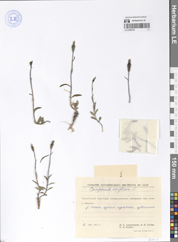
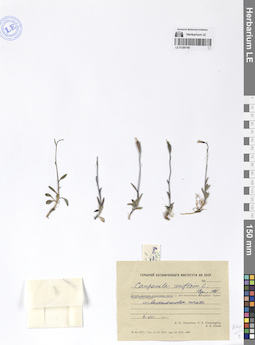
LE 01290796
Campanula uniflora L.
Collectors: Gavrilyuk, Victor Antonovich Collection date: 06.07.1957. Administrative regions: RU - Chukotskiy Avtonomnyy Okrug. Groups of specimens: Образцы сектора Сибири и Дальнего Востока РоссииOriginal label text:Чукотский полуостров, юго-восточная оконечность. Мыс Чаплина (64° 24' с. ш., 172° 12' з. д.). На повышениях микрорельефа по ЮВ склону горы.
Coordinates (geographic position): 64° 24′ 19.01″ N, 172° 33′ 26.84″ WComment: 6.VII.1957
В. А. Гаврилюк
Chukotka Peninsula, southeastern end. Mys Chaplin (64° 24' N, 172° 12' W). On the elevations of the microrelief along the southeastern slope of the mountain.
Record creation: 2024-08-04, Daria Yudova, PhotoScan D2.Citation: Specimen LE 01290796 // Virtual herbarium of Komarov Botanical Institute RAS — http://re.herbariumle.ru/012907966.07.1957
Coll. V. A. Gavrilyuk
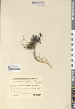
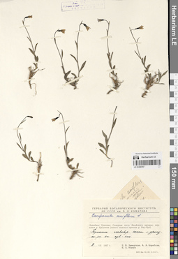
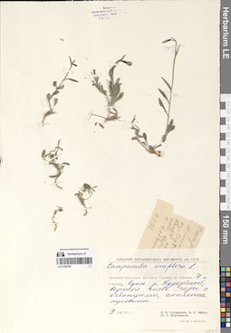
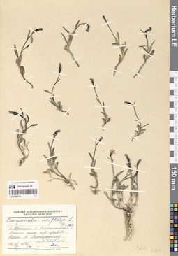
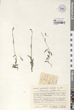
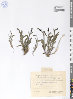
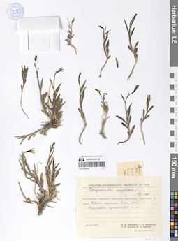
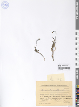
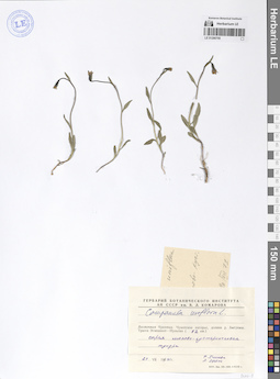
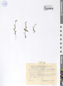
LE 01290795
Campanula uniflora L.
Collectors: Gavrilyuk, Victor Antonovich Collection date: 25.08.1957. Administrative regions: RU - Chukotskiy Avtonomnyy Okrug. Groups of specimens: Образцы сектора Сибири и Дальнего Востока РоссииOriginal label text:Чукотский полуостров, юго-восточная оконечность. Мыс Чаплина (64° 24' с. ш., 172° 12' з. д.). На галечнике в устье реки, близ берега моря.
Coordinates (geographic position): 64° 22′ 55.75″ N, 172° 33′ 24.03″ WComment: 25.VIII.1957
В. А. Гаврилюк
Chukotka Peninsula, southeastern end. Mys Chaplin (64° 24' N, 172° 12' W). On the gravel at the mouth of the river, near the seashore.
Record creation: 2024-08-04, Daria Yudova, PhotoScan D2.Citation: Specimen LE 01290795 // Virtual herbarium of Komarov Botanical Institute RAS — http://re.herbariumle.ru/0129079525.08.1957
Coll. V. A. Gavrilyuk
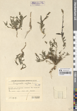
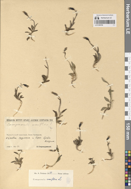
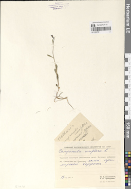
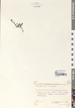
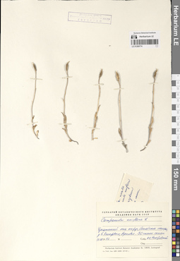
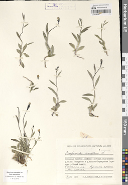
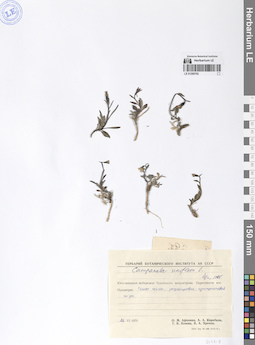
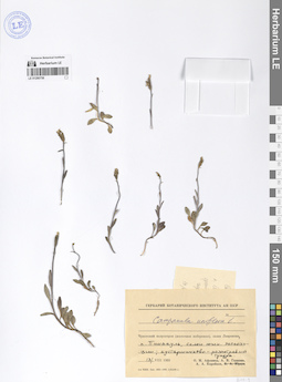
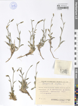
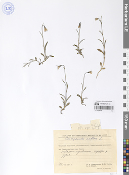
LE 01290794
Campanula uniflora L.
Collectors: Gavrilyuk, Victor Antonovich Collection date: 06.07.1957. Administrative regions: RU - Chukotskiy Avtonomnyy Okrug. Groups of specimens: Образцы сектора Сибири и Дальнего Востока РоссииOriginal label text:Чукотский полуостров, юго-восточная оконечность. Мыс Чаплина (64° 24' с. ш., 172° 12' з. д.). На склоне горы, возле норы евражки.
Coordinates (geographic position): 64° 26′ 24.26″ N, 172° 27′ 31.37″ WComment: 6.VII.1957
В. А. Гаврилюк
Chukotka Peninsula, southeastern end. Cape Chaplin (64° 24' N, 172° 12' W). On the mountainside, near a squirrel's burrow.
Record creation: 2024-08-04, Daria Yudova, PhotoScan D2.Citation: Specimen LE 01290794 // Virtual herbarium of Komarov Botanical Institute RAS — http://re.herbariumle.ru/012907946.07.1957
Coll. V. A. Gavrilyuk
LE 01290793
Campanula uniflora L.
Field collecting number: 43. Collection date: 18.07.1954. Administrative regions: RU - Chukotskiy Avtonomnyy Okrug. Groups of specimens: Образцы сектора Сибири и Дальнего Востока РоссииOriginal label text:Остров Врангеля, мыс Флоренс, 16 км к N, терраса реки.
Coordinates (geographic position): 71° 18′ 16.13″ N, 179° 15′ 56.06″ EComment: № 43
18.VII.1954
[...]
Wrangel Island, Cape Florence, 16 km to the N, river terrace.
Record creation: 2024-08-04, Daria Yudova, PhotoScan D2.Citation: Specimen LE 01290793 // Virtual herbarium of Komarov Botanical Institute RAS — http://re.herbariumle.ru/01290793№ 43
18.07.1954
Coll. [...]
LE 01290792
Campanula uniflora L.
Collectors: Gavrilyuk, Victor Antonovich Collection date: 15.07.1962. Administrative regions: RU - Chukotskiy Avtonomnyy Okrug. Groups of specimens: Образцы сектора Сибири и Дальнего Востока РоссииOriginal label text:Чукотский национальный округ, город Анадырь, в В от аэропорта (в 2-3 км). На склоне щебнистого холма.
Coordinates (geographic position): 64° 42′ 51.34″ N, 177° 47′ 16.5″ EComment: 15.VII.1962
В. Гаврилюк
Chukotka National Okrug, the city of Anadyr, in the east from the airport (2-3 km). On the slope of a gravelly hill.
Record creation: 2024-08-04, Daria Yudova, PhotoScan D2.Citation: Specimen LE 01290792 // Virtual herbarium of Komarov Botanical Institute RAS — http://re.herbariumle.ru/0129079215.07.1962
Coll. V. Gavrilyuk
LE 01290791
Campanula uniflora L.
Administrative regions: RU - Chukotskiy Avtonomnyy Okrug. Groups of specimens: Образцы сектора Сибири и Дальнего Востока РоссииRecord creation: 2024-08-04, Daria Yudova, PhotoScan D2.Citation: Specimen LE 01290791 // Virtual herbarium of Komarov Botanical Institute RAS — http://re.herbariumle.ru/01290791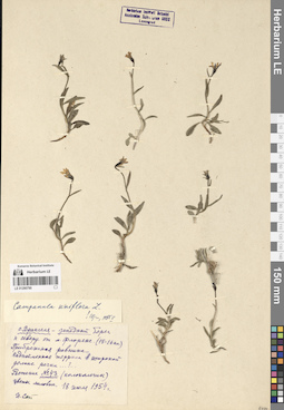
LE 01290790
Campanula uniflora L.
Field collecting number: 43. Collection date: 18.07.1954. Administrative regions: RU - Chukotskiy Avtonomnyy Okrug. Groups of specimens: Образцы сектора Сибири и Дальнего Востока РоссииOriginal label text:Остров Врангеля - западный берег к северу от мыса Флоренс (15-16 км). Прибрежная равнина. Надпойменная терраса в широкой долине речки.
Coordinates (geographic position): 71° 18′ 22.16″ N, 179° 15′ 58.27″ EComment: Растение № 43 (колокольчик)
цветы лиловые
18 июля 1954 г.
[...]
Wrangel Island - the western coast north of Cape Florence (15-16 km). Coastal plain. Floodplain terrace in a wide river valley.
Record creation: 2024-08-04, Daria Yudova, PhotoScan D2.Citation: Specimen LE 01290790 // Virtual herbarium of Komarov Botanical Institute RAS — http://re.herbariumle.ru/01290790lilac flowers
18.07.1954
Coll. [...]
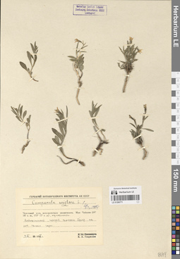
LE 01290789
Campanula uniflora L.
Collectors: Tikhomirov, Boris Anatolievich Collection date: 09.07.1958. Administrative regions: RU - Chukotskiy Avtonomnyy Okrug. Groups of specimens: Образцы сектора Сибири и Дальнего Востока РоссииOriginal label text:Чукотский полуостров, бухта Эмма (64° 30' с. ш., 172° 30' з. д.). Ясная Поляна. У подножья горы, луговинный участок.
Coordinates (geographic position): 64° 26′ 35.85″ N, 173° 9′ 54.59″ WComment: 9.VII.1958
Б. А. Тихомиров
Chukotka Peninsula, Emma Bay (64° 30' N, 172° 30' W). Yasnaya Polyana. At the foot of the mountain, a meadow area.
Record creation: 2024-08-04, Daria Yudova, PhotoScan D2.Citation: Specimen LE 01290789 // Virtual herbarium of Komarov Botanical Institute RAS — http://re.herbariumle.ru/012907899.07.1958
Coll. B. A. Tikhomirov
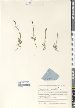
LE 01290788
Campanula uniflora L.
Collectors: Levichev, Igor Germanovich; Korobkov, Aleksandr Aleksandrovich; Jurtzev, Boris Alexandrovich Collection date: 11.08.1968. Administrative regions: RU - Chukotskiy Avtonomnyy Okrug. Groups of specimens: Образцы сектора Сибири и Дальнего Востока РоссииOriginal label text:Западная Чукотка. Остров Айон. Правый берег реки Утатгыр в нижнем течении. Сухой южный песчаный склон. Кобрезиевая тундра.
Coordinates (geographic position): 69° 53′ 6.45″ N, 167° 54′ 55.9″ EComment: 11.VIII.1968
И. Г. Левичев, А. А. Коробков, Б. А. Юрцев
Western Chukotka. Ayon Island. Right bank of the Utatgyr River in the lower reaches. Dry southern sandy slope. Kobresia tundra.
Record creation: 2024-08-04, Daria Yudova, PhotoScan D2.Citation: Specimen LE 01290788 // Virtual herbarium of Komarov Botanical Institute RAS — http://re.herbariumle.ru/0129078811.08.1968
Coll. I. G. Levichev, A. A. Korobkov, B. A. Jurtzev
LE 01290787
Campanula uniflora L.
Collectors: Zimarskaya, Ekaterina V.; Korobkov, Aleksandr Aleksandrovich; Jurtzev, Boris Alexandrovich Collection date: 08.07.1967. Administrative regions: RU - Chukotskiy Avtonomnyy Okrug. Groups of specimens: Образцы сектора Сибири и Дальнего Востока РоссииOriginal label text:Западная Чукотка. Северная часть Анюйского нагорья, верховья реки Ергувеем (левого нижнего притока реки Рау-Чуа). Подножье левобережной сопки - дриадовая тундра на известняках.
Coordinates (geographic position): 69° 11′ 19.16″ N, 165° 37′ 6.27″ EComment: 8.VII.1967
Е. В. Зимарская, А. А. Коробков, Б. А. Юрцев
Western Chukotka. Northern part of the Anyui plateau, upper reaches of the Erguveem river (left lower tributary of the Rau-Chua river). The foot of the left-bank hill is dryad tundra on limestone.
Record creation: 2024-08-04, Daria Yudova, PhotoScan D2.Citation: Specimen LE 01290787 // Virtual herbarium of Komarov Botanical Institute RAS — http://re.herbariumle.ru/012907878.07.1967
Coll. E. V. Zimarskaya, A. A. Korobkov, B. A. Jurtzev.
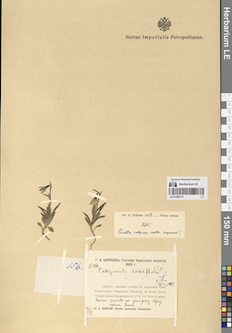
LE 01290786
Campanula uniflora L. det. Fedorov, Andrey Aleksandrovich at 1953
Collectors: Starokadomsky, Leonid Mikhailovich Collection date: 21.07.1932. Administrative regions: RU - Chukotskiy Avtonomnyy Okrug. Groups of specimens: Образцы сектора Сибири и Дальнего Востока РоссииOriginal label text:Чукотский полуостров. Залив Провидения. Островок Эрдмана и берег бухты Всадник.
Coordinates (geographic position): 64° 33′ 24.43″ N, 173° 17′ 59.29″ WComment: 21.VII.1932
Л. Старокадомский
Chukotka Peninsula. Providence Bay. Erdman Island and the shore of Vsadnik Bay.
Record creation: 2024-08-04, Daria Yudova, PhotoScan D2.Citation: Specimen LE 01290786 // Virtual herbarium of Komarov Botanical Institute RAS — http://re.herbariumle.ru/0129078621.07.1932
Coll. L. Starokadomsky
LE 01290785
Campanula uniflora L.
Collectors: Kozhevnikov, Yury Pavlovich Collection date: 15.07.1972. Administrative regions: RU - Chukotskiy Avtonomnyy Okrug. Groups of specimens: Образцы сектора Сибири и Дальнего Востока РоссииOriginal label text:Центральная Чукотка. Бассейн реки Чантальвеергын. Река Чантальвеергын в 40 км от устья. N скалистый берег реки.
Coordinates (geographic position): 67° 56′ 2.28″ N, 179° 57′ 10.63″ WComment: 15.07.1972
Ю. П. Кожевников
Central Chukotka. Chantalveergyn River basin. Chantalveergyn River 40 km from its mouth. N rocky river bank.
Record creation: 2024-08-04, Daria Yudova, PhotoScan D2.Citation: Specimen LE 01290785 // Virtual herbarium of Komarov Botanical Institute RAS — http://re.herbariumle.ru/0129078515.07.1972
Coll. Yu. P. Kozhevnikov
LE 01290784
Campanula uniflora L.
Collectors: Kozhevnikov, Yury Pavlovich; Sukhorukova, N. I.; Efros, A. L. Collection date: 30.07.1971. Administrative regions: RU - Chukotskiy Avtonomnyy Okrug. Groups of specimens: Образцы сектора Сибири и Дальнего Востока РоссииOriginal label text:Восточная Чукотка. Чукотское нагорье, южные отроги хребта Искатень, побережье залива Креста близ поселка Эгвекинот. Скалы в долине речки близ аэропорта.
Coordinates (geographic position): 66° 22′ 14.11″ N, 179° 8′ 25.64″ WComment: 30.VII.1971
Ю. Кожевников, Н. Сухорукова, А. Эфрос
Eastern Chukotka. Chukotka Highlands, southern spurs of the Iskateni Ridge, the coast of Kresta Bay near the village of Egvekinot. Cliffs in the river valley near the airport.
30.07.1971
Coll. Yu. Kozhevnikov, N. Sukhorukova, A. Efros
LE 01290783
Campanula uniflora L.
Collectors: Sukhorukova, N. I.; Efros, A. L.; Kozhevnikov, Yury Pavlovich Collection date: 09.07.1971. Administrative regions: RU - Chukotskiy Avtonomnyy Okrug. Groups of specimens: Образцы сектора Сибири и Дальнего Востока РоссииOriginal label text:Чукотский полуостров. Бассейн реки Сеутакан, озеро Сеутакан, 7 км к востоку, вдоль реки Курортной, верхняя часть горы с останцами, скальные луговины.
Coordinates (geographic position): 65° 45′ 59.65″ N, 176° 37′ 23.61″ WComment: 9.VII.1971
Н. И. Сухорукова, А. Л. Эфрос, Ю. П. Кожевников
Chukotka Peninsula. Seutakan River basin, Seutakan Lake, 7 km to the east, along the Kurortnaya River, upper part of the mountain with outliers, rocky meadows.
Record creation: 2024-08-04, Daria Yudova, PhotoScan D2.Citation: Specimen LE 01290783 // Virtual herbarium of Komarov Botanical Institute RAS — http://re.herbariumle.ru/012907839.07.1971
Coll. N. I. Sukhorukova, A. L. Efros, Yu. P. Kozhevnikov
LE 01290782
Campanula uniflora L.
Collectors: Kozhevnikov, Yury Pavlovich; Sukhorukova, N. I. Collection date: 15.07.1971. Administrative regions: RU - Chukotskiy Avtonomnyy Okrug. Groups of specimens: Образцы сектора Сибири и Дальнего Востока РоссииOriginal label text:Чукотский полуостров (юго-западная часть). Восточное побережье залива Креста близ поселка Конергино, склон приморской террасы.
Coordinates (geographic position): 65° 53′ 21.97″ N, 178° 49′ 44.98″ WComment: 15.VII.1971
Ю. П. Кожевников, Н. И. Сухорукова
Chukotka Peninsula (southwestern part). The eastern coast of Kresta Bay near the village of Konergino, the slope of the seaside terrace.
Record creation: 2024-08-04, Daria Yudova, PhotoScan D2.Citation: Specimen LE 01290782 // Virtual herbarium of Komarov Botanical Institute RAS — http://re.herbariumle.ru/0129078215.07.1971
Coll. Yu. P. Kozhevnikov, N. I. Sukhorukova
LE 01290781
Campanula uniflora L.
Collectors: Zimarskaya, Ekaterina V.; Korobkov, Aleksandr Aleksandrovich; Jurtzev, Boris Alexandrovich Collection date: 09.07.1967. Administrative regions: RU - Chukotskiy Avtonomnyy Okrug. Groups of specimens: Образцы сектора Сибири и Дальнего Востока РоссииOriginal label text:Западная Чукотка. Северная часть Анюйского нагорья, верховья реки Ергувеем (левого нижнего притока реки Рау-Чуа). Левобережье ручья Ловкого, верхняя часть пологого Ю-В склона, щебн.-пятн.-дриад.-осочк. тундра на известняковых сланцах.
Comment: 9.VII.1967
Е. В. Зимарская, А. А. Коробков, Б. А. Юрцев
Western Chukotka. Northern part of the Anyui plateau, upper reaches of the Erguveem River (left lower tributary of the Rau-Chua River). Left bank of the Lovky Creek, upper part of the gentle SE slope, tundra on limestone shales.
Record creation: 2024-08-04, Daria Yudova, PhotoScan D2.Citation: Specimen LE 01290781 // Virtual herbarium of Komarov Botanical Institute RAS — http://re.herbariumle.ru/012907819.07.1967
Coll. E. V. Zimarskaya, A. A. Korobkov, B. A. Jurtzev
LE 01290780
Campanula uniflora L.
Collectors: Tikhmenev, E. A. Field collecting number: 32/170. Collection date: 13.07.1971. Administrative regions: RU - Chukotskiy Avtonomnyy Okrug. Groups of specimens: Образцы сектора Сибири и Дальнего Востока РоссииOriginal label text:Остров Врангеля, бухта Сомнительная, пойменная терраса реки Сомнительной.
Coordinates (geographic position): 70° 56′ 43.73″ N, 179° 36′ 27.59″ WComment: № 32/170
13.VII.1971
Е. Тихменев
Wrangel Island, Somnitelnaya Bay, floodplain terrace of the Somnitelnaya River.
Record creation: 2024-08-04, Daria Yudova, PhotoScan D2.Citation: Specimen LE 01290780 // Virtual herbarium of Komarov Botanical Institute RAS — http://re.herbariumle.ru/01290780№ 32/170
13.07.1971
Coll. E. Tikhmenev
LE 01290779
Campanula uniflora L.
Collectors: Tikhmenev, E. A.; Levkovsky, V. Field collecting number: 72/196. Collection date: 14.07.1971. Administrative regions: RU - Chukotskiy Avtonomnyy Okrug. Groups of specimens: Образцы сектора Сибири и Дальнего Востока РоссииOriginal label text:Остров Врангеля, бухта Сомнительная. Южный склон гор правобережья реки Сомнительной.
Coordinates (geographic position): 70° 58′ 51.6″ N, 179° 33′ 28.93″ WComment: № 72/196
14.VII.1971
Е. Тихменев, В. Левковский
Wrangel Island, Somnitelnaya Bay. Southern slope of the mountains on the right bank of the Somnitelnaya River.
Record creation: 2024-08-04, Daria Yudova, PhotoScan D2.Citation: Specimen LE 01290779 // Virtual herbarium of Komarov Botanical Institute RAS — http://re.herbariumle.ru/01290779№ 72/196
14.07.1971
Coll. E. Tikhmenev, V. Levkovsky
LE 01290778
Campanula uniflora L.
Collectors: Sekretareva, Nadezhda Alexandrovna; Sytin, Andrej Kirillovich; Jurtzev, Boris Alexandrovich Collection date: 15.07.1971. Administrative regions: RU - Chukotskiy Avtonomnyy Okrug. Groups of specimens: Образцы сектора Сибири и Дальнего Востока РоссииOriginal label text:Чукотский полуостров (восточная часть). Северо-западная оконечность залива Лаврентия близ мыса Краузе. 2 км к ЮВ от мыса Краузе, нивальная тундра над береговым снежником.
Coordinates (geographic position): 65° 47′ 16.01″ N, 171° 25′ 48.89″ WComment: 15.VII.1971
Н. А. Секретарева, А. К. Сытин, Б. А. Юрцев
Chukotka Peninsula (eastern part). Northwestern end of the Gulf of Lavrentiya near Cape Krause. 2 km SE of Cape Krause, nival tundra above coastal snowfield.
Record creation: 2024-08-04, Daria Yudova, PhotoScan D2.Citation: Specimen LE 01290778 // Virtual herbarium of Komarov Botanical Institute RAS — http://re.herbariumle.ru/0129077815.07.1971
Coll. N. A. Sekretareva, A. K. Sytin, B. A. Jurtzev
LE 01290777
Campanula uniflora L.
Collectors: Andreev, Mikhail Petrovich; Norkina, E. Yu.; Petrovsky, Vladislav Vladimirovich Collection date: 26.08.1977. Administrative regions: RU - Chukotskiy Avtonomnyy Okrug. Groups of specimens: Образцы сектора Сибири и Дальнего Востока РоссииOriginal label text:Западная Чукотка. Анюйское нагорье - северная часть. Река Кытеп-Гуйтеньрывеем - среднее течение. Река Милькера. На S склоне.
Coordinates (geographic position): 69° 17′ 37.51″ N, 165° 16′ 19.23″ EComment: 26.08.1977
М. П. Андреев, Е. Ю. Норкина, В. В. Петровский
Western Chukotka. Anyui Highland - northern part. Kytep-Guytenryveem River - middle course. Milkera River. On the S slope.
Record creation: 2024-08-04, Daria Yudova, PhotoScan D2.Citation: Specimen LE 01290777 // Virtual herbarium of Komarov Botanical Institute RAS — http://re.herbariumle.ru/0129077726.08.1977
Coll. M. P. Andreev, E. Yu. Norkina, V. V. Petrovsky
LE 01290776
Campanula uniflora L.
Collectors: Katenin, Adrian Evgenevich Collection date: 17.08.1977. Administrative regions: RU - Chukotskiy Avtonomnyy Okrug. Groups of specimens: Образцы сектора Сибири и Дальнего Востока РоссииOriginal label text:Чукотский полуостров, центральная часть. Окрестности озера Иони, река Ионивеем (среднее течение), гора Иони. Верхняя часть нивального уступа в долине речки, стекающей с горы Иони.
Coordinates (geographic position): 65° 56′ 11.65″ N, 173° 50′ 25.17″ WComment: 17.VIII.1977
А. Е. Катенин
Chukotka Peninsula, central part. Vicinity of Lake Ioni, Ioniveem River (middle reaches), Mount Ioni. Upper part of nival ledge in the valley of the river flowing down from Mount Ioni.
Record creation: 2024-08-04, Daria Yudova, PhotoScan D2.Citation: Specimen LE 01290776 // Virtual herbarium of Komarov Botanical Institute RAS — http://re.herbariumle.ru/0129077617.08.1977
Coll. A. E. Katenin
LE 01290775
Campanula uniflora L.
Collectors: Boitsova, M. S.; Katenin, Adrian Evgenevich; Krivova, S. A.; Polozova, Tamara Georgievna Collection date: 19.07.1977. Administrative regions: RU - Chukotskiy Avtonomnyy Okrug. Groups of specimens: Образцы сектора Сибири и Дальнего Востока РоссииOriginal label text:Чукотский полуостров (центральная часть). Горячие ключи на реке Гильмимливеем (в 15 км к востоку от озера Иони). Дриадовая тундра на сухом взлобке склона западной экспозиции в боковом ущелье.
Coordinates (geographic position): 65° 48′ 28.01″ N, 173° 21′ 26.36″ WComment: 19.VII.1977
М. С. Бойцова, А. Е. Катенин, С. А. Кривова, Т. Г. Полозова
Chukotka Peninsula (central part). Hot springs on the Gilmimliveyem River (15 km east of Lake Ioni). Dryad tundra on a dry hillside of a western exposure slope in a side gorge.
Record creation: 2024-08-04, Daria Yudova, PhotoScan D2.Citation: Specimen LE 01290775 // Virtual herbarium of Komarov Botanical Institute RAS — http://re.herbariumle.ru/0129077519.07.1977
Coll. M. S. Boitsova, A. E. Katenin, S. A. Krivova, T. G. Polozova
LE 01290774
Campanula uniflora L.
Collectors: Petrovsky, Vladislav Vladimirovich Collection date: 17.08.1973. Administrative regions: RU - Chukotskiy Avtonomnyy Okrug. Groups of specimens: Образцы сектора Сибири и Дальнего Востока РоссииOriginal label text:Чукотский национальный округ, Анюйское нагорье, река Большой Кепервеем, верховья. SO склон сопки.
Coordinates (geographic position): 68° 10′ 24.95″ N, 166° 39′ 23.87″ EComment: 17.08.1973
В. В. Петровский
Chukotka National Okrug, Anyui Highland, Bolshoy Keperveem River, upper reaches. SO slope of the hill.
Record creation: 2024-08-04, Daria Yudova, PhotoScan D2.Citation: Specimen LE 01290774 // Virtual herbarium of Komarov Botanical Institute RAS — http://re.herbariumle.ru/0129077417.08.1973
Coll. V. V. Petrovsky
LE 01290773
Campanula uniflora L.
Collectors: Litvinova, N.P.; Tikhmenev, E. A. Collection date: 01.08.1970. Administrative regions: RU - Chukotskiy Avtonomnyy Okrug. Groups of specimens: Образцы сектора Сибири и Дальнего Востока РоссииOriginal label text:Остров Врангеля, бассейн реки Тундровой, окрестности горы Тундровой, южный склон.
Coordinates (geographic position): 71° 18′ 20.64″ N, 179° 48′ 58.35″ WComment: 1.VIII.1970
Н. Литвинова, Е. Тихменев
Wrangel Island, Tundrovaya River basin, vicinity of Tundrovaya Mountain, southern slope.
Record creation: 2024-08-04, Daria Yudova, PhotoScan D2.Citation: Specimen LE 01290773 // Virtual herbarium of Komarov Botanical Institute RAS — http://re.herbariumle.ru/012907731.08.1970
Coll. N. Litvinova, E. Tikhmenev
LE 01290772
Campanula uniflora L.
Collectors: Borisow, G. A. Field collecting number: 156. Collection date: 04.07.1909. Administrative regions: RU - Chukotskiy Avtonomnyy Okrug. Groups of specimens: Образцы сектора Сибири и Дальнего Востока РоссииOriginal label text:Г. А. Борисов: Растения Чукотского полуострова 1909 г.
Coordinates (geographic position): 64° 25′ 41.12″ N, 173° 13′ 7.85″ WComment: Окрестности торговой станции Св. Владимира Северо-восточного Сибирского Общества, на берегу бухты Эммы в заливе Провидения 64° 45' N, 174° W (от Гринв.).
Склоны холмов по западному берегу бухты Эммы.
4.VII.
G. A. Borisov: Plants of the Chukotka Peninsula 1909
The environs of the trading station of St. Vladimir of the North-Eastern Siberian Society, on the shore of Emma Bay in Providence Bay 64° 45' N, 174° W (from Greenwich).
Slopes of hills along the western shore of Emma Bay.
4.07.1909
Coll. G. A. Borisov
LE 01290771
Campanula uniflora L.
Collectors: Gavrilyuk, Victor Antonovich Collection date: 04.07.1957. Administrative regions: RU - Chukotskiy Avtonomnyy Okrug. Groups of specimens: Образцы сектора Сибири и Дальнего Востока РоссииOriginal label text:Чукотский полуостров, юго-восточная оконечность. Мыс Чаплина (64° 24' с. ш., 172° 12' з. д.), окрестности. Возвышенный, нагреваемый солнцем бугор на ЮВ склоне горы.
Coordinates (geographic position): 64° 24′ 30.99″ N, 172° 15′ 3.99″ WComment: 4.VII.1957
В. А. Гаврилюк
Chukotka Peninsula, southeastern end. Cape Chaplin (64° 24' N, 172° 12' W), environs. An elevated, sun-heated mound on the southeastern slope of the mountain.
Record creation: 2024-08-04, Daria Yudova, PhotoScan D2.Citation: Specimen LE 01290771 // Virtual herbarium of Komarov Botanical Institute RAS — http://re.herbariumle.ru/012907714.07.1957
Coll. V. A. Gavrilyuk
LE 01290770
Campanula uniflora L.
Collectors: Petrovsky, Vladislav Vladimirovich; Koroleva (Zaslavskaya), Tatiana Collection date: 04.08.1976. Administrative regions: RU - Chukotskiy Avtonomnyy Okrug. Groups of specimens: Образцы сектора Сибири и Дальнего Востока РоссииOriginal label text:Западная Чукотка. Анюйское нагорье. Водораздел реки Малый Кепервеем и реки Майнгы-Пауктуваам (притоки реки Малый Анюй). На останце - осыпь.
Coordinates (geographic position): 67° 55′ 17.98″ N, 166° 51′ 25.32″ EComment: 4.VIII.1976
В. В. Петровский, Т. М. Королева
Western Chukotka. Anyui Highland. Watershed of the Maly Keperveem River and the Maingy-Pauktuvaam River (tributaries of the Maly Anyui River).
Record creation: 2024-08-04, Daria Yudova, PhotoScan D2.Citation: Specimen LE 01290770 // Virtual herbarium of Komarov Botanical Institute RAS — http://re.herbariumle.ru/012907704.08.1976
Coll. V. V. Petrovsky, T. M. Koroleva
LE 01290769
Campanula uniflora L.
Collectors: Jurtzev, Boris Alexandrovich Collection date: 11.08.1968. Administrative regions: RU - Chukotskiy Avtonomnyy Okrug. Groups of specimens: Образцы сектора Сибири и Дальнего Востока РоссииOriginal label text:Западная Чукотка. Остров Айон. Долина реки Утатгыр ниже п. южного склона. Кустарничковая тундра.
Coordinates (geographic position): 69° 53′ 42.77″ N, 168° 0′ 1.45″ EComment: 11.VIII.1968
Б. А. Юрцев
Western Chukotka. Ayon Island. Valley of the Utatgyr River. Shrub tundra.
Record creation: 2024-08-04, Daria Yudova, PhotoScan D2.Citation: Specimen LE 01290769 // Virtual herbarium of Komarov Botanical Institute RAS — http://re.herbariumle.ru/0129076911.08.1968
Coll. B. A. Jurtzev
LE 01290768
Campanula uniflora L.
Collectors: Afonina, Olga Mikhailovna; Korobkov, Aleksandr Aleksandrovich; Plieva, T.V.; Khrenov, V. A. Collection date: 12.07.1970. Administrative regions: RU - Chukotskiy Avtonomnyy Okrug. Groups of specimens: Образцы сектора Сибири и Дальнего Востока РоссииOriginal label text:Юго-западное побережье Чукотского полуострова. Окрестности озера Аччен. Устье реки Гранитной, луговинная тундра у подножья склона.
Coordinates (geographic position): 64° 52′ 44.63″ N, 174° 56′ 6.79″ WComment: 12.VII.1970
О. М. Афонина, А. А. Коробков, Т.В. Плиева, В. А. Хренов
Southwest coast of the Chukotka Peninsula. The vicinity of Lake Achchen. The mouth of the Granitnaya River, meadow tundra at the foot of the slope.
Record creation: 2024-08-04, Daria Yudova, PhotoScan D2.Citation: Specimen LE 01290768 // Virtual herbarium of Komarov Botanical Institute RAS — http://re.herbariumle.ru/0129076812.07.1970
Coll. O. M. Afonina, A. A. Korobkov, T.V. Plieva, V. A. Khrenov
LE 01290767
Campanula uniflora L.
Collectors: Afonina, Olga Mikhailovna; Korobkov, Aleksandr Aleksandrovich; Plieva, T.V.; Khrenov, V. A. Collection date: 16.07.1970. Administrative regions: RU - Chukotskiy Avtonomnyy Okrug. Groups of specimens: Образцы сектора Сибири и Дальнего Востока РоссииOriginal label text:Юго-западное побережье Чукотского полуострова. Окрестности озера Аччен. Рыбный промысел. Остепненный склон Ю-В экспозиции.
Coordinates (geographic position): 64° 48′ 57.27″ N, 174° 45′ 0.15″ WComment: 16.VII.1970
О. М. Афонина, А. А. Коробков, Т. В. Плиева, В. А. Хренов
Southwest coast of the Chukotka Peninsula. Vicinity of Lake Achchen. Fishing industry. Steppe slope of south-east exposure.
Record creation: 2024-08-04, Daria Yudova, PhotoScan D2.Citation: Specimen LE 01290767 // Virtual herbarium of Komarov Botanical Institute RAS — http://re.herbariumle.ru/0129076716.07.1970
Coll. O. M. Afonina, A. A. Korobkov, T.V. Plieva, V. A. Khrenov
LE 01290766
Campanula uniflora L.
Collectors: Petrovsky, Vladislav Vladimirovich; Koroleva (Zaslavskaya), Tatiana Collection date: 07.08.1976. Administrative regions: RU - Chukotskiy Avtonomnyy Okrug. Groups of specimens: Образцы сектора Сибири и Дальнего Востока РоссииOriginal label text:Западная Чукотка. Анюйское нагорье. Водораздел реки Малый Кепервеем и реки Майнгы-Пауктуваам (притоки реки Малый Анюй). Останец на вершине сопки. На скалах.
Coordinates (geographic position): 67° 55′ 17.98″ N, 166° 51′ 25.32″ EComment: 7.VIII.1976
В. В. Петровский, Т. М. Королева
Western Chukotka. Anyui Highland. Watershed of the Maly Keperveem River and the Maingy-Pauktuvaam River (tributaries of the Maly Anyui River). On the rocks.
Record creation: 2024-08-04, Daria Yudova, PhotoScan D2.Citation: Specimen LE 01290766 // Virtual herbarium of Komarov Botanical Institute RAS — http://re.herbariumle.ru/012907667.08.1976
Coll. V. V. Petrovsky, T. M. Koroleva
LE 01290765
Campanula uniflora L.
Collectors: Derviz-Sokolova, Tatiana Georgievna Field collecting number: 403. Collection date: 15.07.1958. Administrative regions: RU - Chukotskiy Avtonomnyy Okrug. Groups of specimens: Образцы сектора Сибири и Дальнего Востока РоссииOriginal label text:Чукотский национальный округ. Близ поселка Уэлен. Щебнистая тундра на склоне сопки на высоте 50 м н. ур. м.
Coordinates (geographic position): 66° 9′ 20.61″ N, 169° 46′ 37.5″ WComment: № 403
15.VII.1958
Т. Дервиз-Соколова
Chukotka National District. Near the village of Uelen. Rubbly tundra on the slope of a hill at an altitude of 50 m above sea level.
Record creation: 2024-08-04, Daria Yudova, PhotoScan D2.Citation: Specimen LE 01290765 // Virtual herbarium of Komarov Botanical Institute RAS — http://re.herbariumle.ru/01290765№ 403
15.07.1958
Coll. T. Derviz-Sokolova
LE 01290764
Campanula uniflora L.
Collectors: Afonina, Olga Mikhailovna; Galanin, Alexander Vladimirovich; Korobkov, Aleksandr Aleksandrovich Collection date: 06.08.1969. Administrative regions: RU - Chukotskiy Avtonomnyy Okrug. Groups of specimens: Образцы сектора Сибири и Дальнего Востока РоссииOriginal label text:Чукотский полуостров (восточное побережье), залив Лаврентия. Поселок Лаврентия, кустарниково-лишайниковая каменистая тундра на склоне.
Coordinates (geographic position): 65° 35′ 57.14″ N, 171° 2′ 29.8″ WComment: 8.VIII.1969
О. М. Афонина, А. В. Галанин, А. А. Коробков
Chukotka Peninsula (east coast), Lavrentiya Bay. Lavrentiya village, shrub-lichen rocky tundra on the slope.
Record creation: 2024-08-04, Daria Yudova, PhotoScan D2.Citation: Specimen LE 01290764 // Virtual herbarium of Komarov Botanical Institute RAS — http://re.herbariumle.ru/012907646.08.1969
Coll. O. M. Afonina, A. V. Galanin, A. A. Korobkov
LE 01290763
Campanula uniflora L.
Collectors: Afonina, Olga Mikhailovna; Korobkov, Aleksandr Aleksandrovich; Plieva, T.V.; Khrenov, V. A. Collection date: 07.07.1970. Administrative regions: RU - Chukotskiy Avtonomnyy Okrug. Groups of specimens: Образцы сектора Сибири и Дальнего Востока РоссииOriginal label text:Юго-западное побережье Чукотского полуострова. Окрестности озера Аччен. Рыбный промысел. Склон сопки. Разнотравно-кустарничковая тундра.
Coordinates (geographic position): 64° 49′ 57.6″ N, 174° 42′ 48.34″ WComment: 7.VII.1970
О. М. Афонина, А. А. Коробков, Т. В. Плиева, В. А. Хренов
Southwest coast of the Chukotka Peninsula. Lake Achchen area. Fishing industry. Hill slope. Forb-shrub tundra.
Record creation: 2024-08-04, Daria Yudova, PhotoScan D2.Citation: Specimen LE 01290763 // Virtual herbarium of Komarov Botanical Institute RAS — http://re.herbariumle.ru/012907637.07.1970
Coll. O. M. Afonina, A. A. Korobkov, T. V. Plieva, V. A. Khrenov
LE 01290762
Campanula uniflora L.
Collectors: Afonina, Olga Mikhailovna; Korobkov, Aleksandr Aleksandrovich; Plieva, T.V.; Khrenov, V. A. Collection date: 28.06.1970. Administrative regions: RU - Chukotskiy Avtonomnyy Okrug. Groups of specimens: Образцы сектора Сибири и Дальнего Востока РоссииOriginal label text:Юго-западное побережье Чукотского полуострова. Окрестности поселка Нунлигран. Склон сопки, разнотравно-кустарниковая тундра.
Coordinates (geographic position): 64° 47′ 35.8″ N, 175° 20′ 10.32″ WComment: 29.VI.1970
О. М. Афонина, А. А. Коробков, Т. В. Плиева, В. А. Хренов
Southwest coast of the Chukotka Peninsula. The outskirts of the village of Nunligran. Hillside, grass-shrub tundra.
Record creation: 2024-08-04, Daria Yudova, PhotoScan D2.Citation: Specimen LE 01290762 // Virtual herbarium of Komarov Botanical Institute RAS — http://re.herbariumle.ru/0129076228.06.1970
Coll. O. M. Afonina, A. A. Korobkov, T. V. Plieva, V. A. Khrenov
LE 01290761
Campanula uniflora L.
Collectors: Afonina, Olga Mikhailovna; Korobkov, Aleksandr Aleksandrovich; Plieva, T.V.; Khrenov, V. A. Collection date: 29.06.1970. Administrative regions: RU - Chukotskiy Avtonomnyy Okrug. Groups of specimens: Образцы сектора Сибири и Дальнего Востока РоссииOriginal label text:Юго-западное побережье Чукотского полуострова. Окрестности поселка Нунлигран. Около свалки.
Coordinates (geographic position): 64° 48′ 21.1″ N, 175° 23′ 38.08″ WComment: 29.VI.1970
О. М. Афонина, А. А. Коробков, Т. В. Плиева, В. А. Хренов
Southwest coast of the Chukotka Peninsula. The outskirts of the village of Nunligran.
Record creation: 2024-08-04, Daria Yudova, PhotoScan D2.Citation: Specimen LE 01290761 // Virtual herbarium of Komarov Botanical Institute RAS — http://re.herbariumle.ru/0129076129.06.1970
Coll. O. M. Afonina, A. A. Korobkov, T. V. Plieva, V. A. Khrenov
LE 01290760
Campanula uniflora L.
Collection date: 28.08.1969. Administrative regions: RU - Chukotskiy Avtonomnyy Okrug. Groups of specimens: Образцы сектора Сибири и Дальнего Востока РоссииOriginal label text:Чукотский полуостров (восточное побережье), залив Лаврентия, бухта Пуотен; каменистый склон сопки; граниты.
Coordinates (geographic position): 65° 51′ 58.06″ N, 170° 32′ 9.14″ WComment: 28.VIII.1969
А. А. Коробков
Chukotka Peninsula (east coast), Lavrentiya Gulf, Puoten Bay; rocky slope of a hill; granites.
Record creation: 2024-08-04, Daria Yudova, PhotoScan D2.Citation: Specimen LE 01290760 // Virtual herbarium of Komarov Botanical Institute RAS — http://re.herbariumle.ru/0129076028.08.1969
Coll. A. A. Korobkov
LE 01290759
Campanula uniflora L.
Collectors: Jurtzev, Boris Alexandrovich Collection date: 14.07.1969. Administrative regions: RU - Chukotskiy Avtonomnyy Okrug. Groups of specimens: Образцы сектора Сибири и Дальнего Востока РоссииOriginal label text:Чукотский полуостров (восточное побережье), залив Лаврентия, поселок Пинакуль, высокий берег залива, южный склон; травянисто-кустарничковая тундра на известняке.
Coordinates (geographic position): 65° 37′ 22.47″ N, 170° 50′ 2.59″ WComment: 13.VIII.1969
Б. А. Юрцев
Chukotka Peninsula (eastern coast), Lavrentiya Gulf, Pinakul settlement, high bank of the gulf, southern slope; grassy-shrub tundra on limestone.
Record creation: 2024-08-04, Daria Yudova, PhotoScan D2.Citation: Specimen LE 01290759 // Virtual herbarium of Komarov Botanical Institute RAS — http://re.herbariumle.ru/0129075914.07.1969
Coll. B. A. Jurtzev
LE 01290758
Campanula uniflora L.
Collectors: Afonina, Olga Mikhailovna; Galanin, Alexander Vladimirovich; Korobkov, Aleksandr Aleksandrovich Collection date: 13.08.1969. Administrative regions: RU - Chukotskiy Avtonomnyy Okrug. Groups of specimens: Образцы сектора Сибири и Дальнего Востока РоссииOriginal label text:Чукотский полуостров (восточное побережье), залив Лаврентия, поселок Пинакуль, склон южной экспозиции; кустарниково-разнотравная тундра.
Coordinates (geographic position): 65° 37′ 22.47″ N, 170° 50′ 2.59″ WComment: 13.VIII.1969
О. М. Афонина, А. В. Галанин, А. А. Коробков
Chukotka Peninsula (eastern coast), Lavrentiya Gulf, Pinakul village, southern slope; shrub-forb tundra.
Record creation: 2024-08-04, Daria Yudova, PhotoScan D2.Citation: Specimen LE 01290758 // Virtual herbarium of Komarov Botanical Institute RAS — http://re.herbariumle.ru/0129075813.08.1969
Coll. O. M. Afonina, A. V. Galanin, A. A. Korobkov
LE 01290757
Campanula uniflora L.
Collectors: Afonina, Olga Mikhailovna; Korobkov, Aleksandr Aleksandrovich Collection date: 08.08.1969. Administrative regions: RU - Chukotskiy Avtonomnyy Okrug. Groups of specimens: Образцы сектора Сибири и Дальнего Востока РоссииOriginal label text:Чукотский полуостров (восточное побережье), залив Лаврентия, поселок Лаврентия, склон сопки на берегу моря, в 3 км к северу от поселка; кустарниково-лишайниковая тундра.
Coordinates (geographic position): 65° 36′ 42.39″ N, 171° 2′ 30.99″ WComment: 8.VIII.1969
О. М. Афонина, А. А. Коробков
Chukotka Peninsula (eastern coast), Lavrentiya Bay, Lavrentiya village, slope of a hill on the seashore, 3 km north of the village; shrub-lichen tundra.
Record creation: 2024-08-04, Daria Yudova, PhotoScan D2.Citation: Specimen LE 01290757 // Virtual herbarium of Komarov Botanical Institute RAS — http://re.herbariumle.ru/012907578.08.1969
Coll. O. M. Afonina, A. A. Korobkov
LE 01290756
Campanula uniflora L.
Collectors: Afonina, Olga Mikhailovna; Korobkov, Aleksandr Aleksandrovich; Plieva, T.V. Collection date: 02.07.1970. Administrative regions: RU - Chukotskiy Avtonomnyy Okrug. Groups of specimens: Образцы сектора Сибири и Дальнего Востока РоссииOriginal label text:Юго-западное побережье Чукотского полуострова. Поселок Нунлигран.
Coordinates (geographic position): 64° 48′ 21.1″ N, 175° 23′ 38.08″ WComment: 2.VII.1970
О. М. Афонина, А. А. Коробков, Т. В. Плиева
Southwest coast of the Chukotka Peninsula. The village of Nunligran.
2.07.1970
Coll. O. M. Afonina, A. A. Korobkov, T. V. Plieva
LE 01290755
Campanula uniflora L.
Collectors: Plieva, T.V.; Efros, A. L. Collection date: 20.07.1971. Administrative regions: RU - Chukotskiy Avtonomnyy Okrug. Groups of specimens: Образцы сектора Сибири и Дальнего Востока РоссииOriginal label text:Восточная Чукотка. Чукотское нагорье, долина реки Амгуема. Трасса Эгвекинот - Иультин (52 км). Сырая мохово-кустарничковая тундра.
Coordinates (geographic position): 66° 43′ 57.45″ N, 179° 0′ 33.65″ WComment: 20.VII.1971
Т. Плиева, А. Эфрос
Eastern Chukotka. Chukotka Highlands, Amguema River Valley. Egvekinot - Iultin Highway (52 km). Damp moss-shrub tundra.
Record creation: 2024-08-04, Daria Yudova, PhotoScan D2.Citation: Specimen LE 01290755 // Virtual herbarium of Komarov Botanical Institute RAS — http://re.herbariumle.ru/0129075520.07.1971
Coll. T. V. Plieva, A. Efros
LE 01290754
Campanula uniflora L.
Collectors: Katenin, Adrian Evgenevich; Plieva, T.V. Collection date: 10.07.1971. Administrative regions: RU - Chukotskiy Avtonomnyy Okrug. Groups of specimens: Образцы сектора Сибири и Дальнего Востока РоссииOriginal label text:Восточная Чукотка. Хребет Искантень (перевал), близ 32 км трассы Эгвекинот - Иультин. Река В. Матачингай, озеро Матачингайское, щебнистый склон СВ экспозиции.
Coordinates (geographic position): 66° 37′ 49.81″ N, 179° 17′ 46.88″ WComment: 10.VII.1971
А. Е. Катенин, Т. В. Плиева
Eastern Chukotka. Iskant'en Ridge (pass), near 32 km of the Egvekinot-Iultin highway. Matachingay River, Matachingay Lake, gravelly slope of NE exposure.
Record creation: 2024-08-04, Daria Yudova, PhotoScan D2.Citation: Specimen LE 01290754 // Virtual herbarium of Komarov Botanical Institute RAS — http://re.herbariumle.ru/0129075410.07.1971
Coll. A. E. Katenin, T. V. Plieva
LE 01290753
Campanula uniflora L.
Collectors: Plieva, T.V. Collection date: 10.07.1969. Administrative regions: RU - Chukotskiy Avtonomnyy Okrug. Groups of specimens: Образцы сектора Сибири и Дальнего Востока РоссииOriginal label text:Чукотский полуостров, верховья реки Ионивеем при впадении реки Теркэмкын. Луговина на высокой пойме.
Coordinates (geographic position): 65° 10′ 58.37″ N, 173° 46′ 28.19″ WComment: 10.VII.1969
Т. В. Плиева
Chukotka Peninsula, upper reaches of the Ioniveem River at the confluence with the Terkemkyn River. Meadow on a high floodplain.
Record creation: 2024-08-04, Daria Yudova, PhotoScan D2.Citation: Specimen LE 01290753 // Virtual herbarium of Komarov Botanical Institute RAS — http://re.herbariumle.ru/0129075310.07.1969
Coll. T. V. Plieva
LE 01290752
Campanula uniflora L.
Collectors: Sekretareva, Nadezhda Alexandrovna; Sytin, Andrej Kirillovich; Jurtzev, Boris Alexandrovich Collection date: 02.08.1971. Administrative regions: RU - Chukotskiy Avtonomnyy Okrug. Groups of specimens: Образцы сектора Сибири и Дальнего Востока РоссииOriginal label text:Чукотский полуостров (северо-восточное побережье) близ устья реки Чегитунь. Западный склон, сухая луговина, известняк.
Coordinates (geographic position): 66° 31′ 26.8″ N, 171° 8′ 56.87″ WComment: 2.VIII.1971
Н. А. Секретарева, А. К. Сытин, Б. А. Юрцев
Chukotka Peninsula (northeastern coast) near the mouth of the Chegitun River. Western slope, dry meadow, limestone.
Record creation: 2024-08-04, Daria Yudova, PhotoScan D2.Citation: Specimen LE 01290752 // Virtual herbarium of Komarov Botanical Institute RAS — http://re.herbariumle.ru/012907522.08.1971
Coll. N. A. Sekretareva, A. K. Sytin, B. A. Jurtzev
LE 01290751
Campanula uniflora L.
Collectors: Sekretareva, Nadezhda Alexandrovna; Sytin, Andrej Kirillovich; Jurtzev, Boris Alexandrovich Collection date: 20.07.1971. Administrative regions: RU - Chukotskiy Avtonomnyy Okrug. Groups of specimens: Образцы сектора Сибири и Дальнего Востока РоссииOriginal label text:(венчик почти белый со слабым лиловатым оттенком)
Coordinates (geographic position): 65° 47′ 11.5″ N, 171° 26′ 17.33″ WComment: Чукотский полуостров (восточная часть). Северо-западная оконечность залива Лаврентия близ мыса Краузе. Долина реки Шумной близ устья, подножье ЮВ склона, луговинная кустарничковая тундра.
20.VII.1971
Н. А. Секретарева, А. К. Сытин, Б. А. Юрцев
(the corolla is almost white with a slight lilac tint)
Record creation: 2024-08-04, Daria Yudova, PhotoScan D2.Citation: Specimen LE 01290751 // Virtual herbarium of Komarov Botanical Institute RAS — http://re.herbariumle.ru/01290751Chukotka Peninsula (eastern part). The northwestern end of the Gulf of Lavrentiya near Cape Krause. The valley of the Shumnaya River near its mouth, the foot of the southeastern slope, meadow shrub tundra.
20.07.1971
Coll. N. A. Sekretareva, A. K. Sytin, B. A. Jurtzev
LE 01290750
Campanula uniflora L.
Collectors: Sekretareva, Nadezhda Alexandrovna; Sytin, Andrej Kirillovich; Jurtzev, Boris Alexandrovich Collection date: 15.07.1971. Administrative regions: RU - Chukotskiy Avtonomnyy Okrug. Groups of specimens: Образцы сектора Сибири и Дальнего Востока РоссииOriginal label text:Чукотский полуостров (восточная часть). Северо-западная оконечность залива Лаврентия близ мыса Краузе. Нивально-луговинная тундра у ручья.
Coordinates (geographic position): 65° 48′ 10.99″ N, 171° 26′ 57.19″ WComment: 15.VII.1971
Н. А. Секретарева, А. К. Сытин, Б. А. Юрцев
Chukotka Peninsula (eastern part). Northwestern end of the Gulf of Lavrentiya near Cape Krause. Nival-meadow tundra near a stream.
Record creation: 2024-08-04, Daria Yudova, PhotoScan D2.Citation: Specimen LE 01290750 // Virtual herbarium of Komarov Botanical Institute RAS — http://re.herbariumle.ru/0129075015.07.1971
Coll. N. A. Sekretareva, A. K. Sytin, B. A. Jurtzev
LE 01290749
Campanula uniflora L.
Collectors: Sekretareva, Nadezhda Alexandrovna; Sytin, Andrej Kirillovich; Jurtzev, Boris Alexandrovich Collection date: 08.07.1971. Administrative regions: RU - Chukotskiy Avtonomnyy Okrug. Groups of specimens: Образцы сектора Сибири и Дальнего Востока РоссииOriginal label text:Чукотский полуостров (южная часть). Залив Провидения, бухта Эммы. Горы к западу от низины между бухтой Эммы и озером Истихед, сухая мелкокаменистая кустарничкого-лишайниковая тундра на восточном склоне, делювий гранита. (венчик синий или бледно-лиловый (разница интенсивности; уже к закладке гербария разница исчезла).
Coordinates (geographic position): 64° 22′ 49.4″ N, 173° 14′ 56.7″ WComment: 8.VII.1971
Н. А. Секретарева, А. К. Сытин, Б. А. Юрцев
Chukotka Peninsula (southern part). Providence Gulf, Emma Bay. Mountains to the west of the lowland between Emma Bay and Lake Istikhed, dry fine-stony shrub-lichen tundra on the eastern slope, granite deluvium. (corolla blue or pale purple (difference in intensity; by the time the herbarium was laid out the difference had disappeared).
Record creation: 2024-08-04, Daria Yudova, PhotoScan D2.Citation: Specimen LE 01290749 // Virtual herbarium of Komarov Botanical Institute RAS — http://re.herbariumle.ru/012907498.07.1971
Coll. N. A. Sekretareva, A. K. Sytin, B. A. Jurtzev
LE 01290748
Campanula uniflora L.
Collectors: Razzhivin, Vladimir Yurievich; Sekretareva, Nadezhda Alexandrovna; Jurtzev, Boris Alexandrovich Collection date: 06.08.1972. Administrative regions: RU - Chukotskiy Avtonomnyy Okrug. Groups of specimens: Образцы сектора Сибири и Дальнего Востока РоссииOriginal label text:Остров Итыгран (восточная часть) у юго-восточного побережья Чукотского полуострова. Известняковое плато.
Coordinates (geographic position): 64° 37′ 16.07″ N, 172° 27′ 48.54″ WComment: 6.VIII.1972
В. Ю. Разживин, Н. А. Секретарева, Б. А. Юрцев
Itygran Island (eastern part) off the southeastern coast of the Chukotka Peninsula. Limestone plateau.
6.08.1972
Coll. V. Yu. Razzhivin, N. A. Sekretareva, B. A. Jurtzev