View
Add
Copy
Edit
Delete
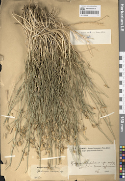
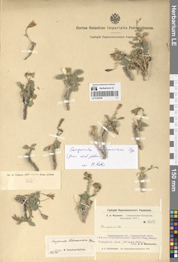
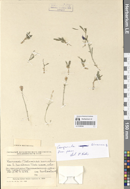
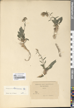
LE 01290362
Groups of specimens: Образцы сектора Средней АзииRecord creation: 2024-08-04, Daria Yudova, PhotoScan D2.Citation: Specimen LE 01290362 // Virtual herbarium of Komarov Botanical Institute RAS — http://re.herbariumle.ru/01290362
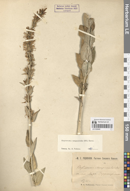
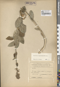
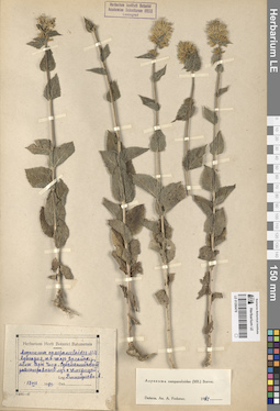
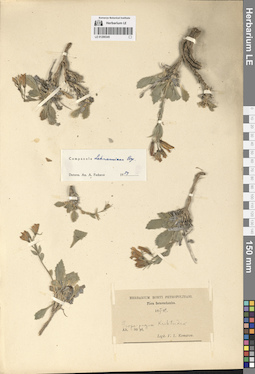
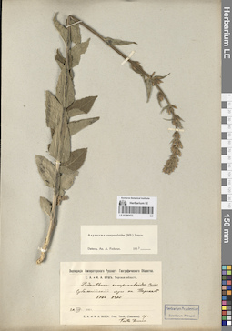
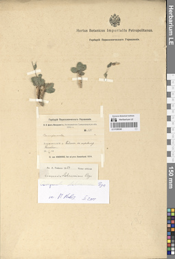
LE 01290490
Asyneuma campanuloides (M. Bieb. ex Sims) Bornm. det. Fedorov, Andrey Aleksandrovich at 1954
Collectors: Hoefft (Höfft), F.A. [Haefft] Groups of specimens: Образцы сектора Кавказа; Соглашение Минобрнауки №075-15-2021-1056Original label text:Ded. Dr. Hoefft 1838
Record creation: 2024-08-04, Daria Yudova, PhotoScan D2.Citation: Specimen LE 01290490 // Virtual herbarium of Komarov Botanical Institute RAS — http://re.herbariumle.ru/01290490Caucasus
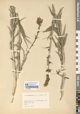
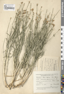
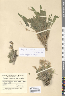
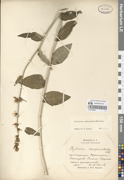
LE 01290361
Groups of specimens: Образцы сектора Средней АзииRecord creation: 2024-08-04, Daria Yudova, PhotoScan D2.Citation: Specimen LE 01290361 // Virtual herbarium of Komarov Botanical Institute RAS — http://re.herbariumle.ru/01290361
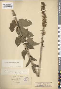
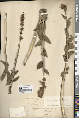
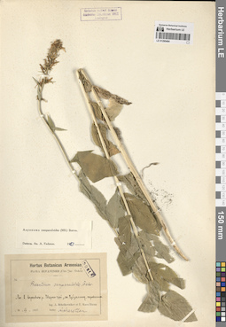
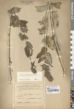
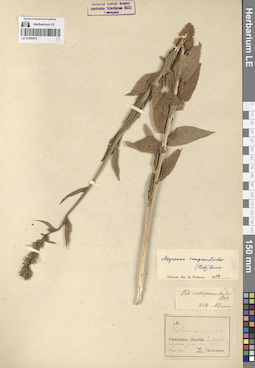
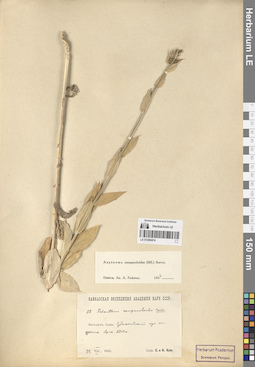
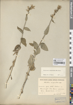
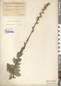
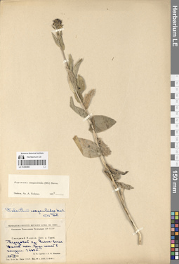
LE 01290489
Asyneuma campanuloides (M. Bieb. ex Sims) Bornm. det. Fedorov, Andrey Aleksandrovich at 1954
Field collecting number: 250. Collection date: 29.07.1885. Groups of specimens: Образцы сектора Кавказа; Соглашение Минобрнауки №075-15-2021-1056Record creation: 2024-08-04, Daria Yudova, PhotoScan D2.Citation: Specimen LE 01290489 // Virtual herbarium of Komarov Botanical Institute RAS — http://re.herbariumle.ru/01290489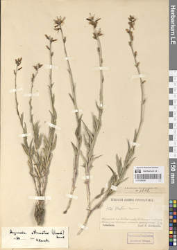
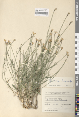
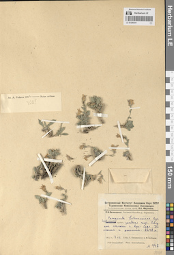
LE 01290360
Groups of specimens: Образцы сектора Средней АзииRecord creation: 2024-08-04, Daria Yudova, PhotoScan D2.Citation: Specimen LE 01290360 // Virtual herbarium of Komarov Botanical Institute RAS — http://re.herbariumle.ru/01290360
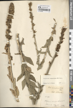
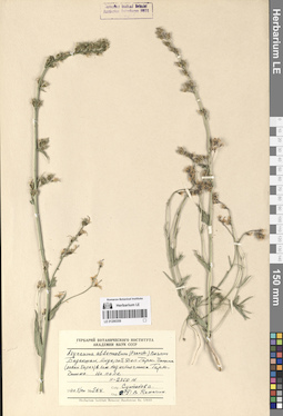
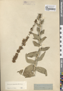
LE 01290488
Asyneuma campanuloides (M. Bieb. ex Sims) Bornm. det. Fedorov, Andrey Aleksandrovich at 1954
Collectors: Becker, Alexander K. Field collecting number: 35. Collection date: 1867. Administrative regions: RU - Stavropol'skiy Kray. Groups of specimens: Образцы сектора Кавказа; Соглашение Минобрнауки №075-15-2021-1056Original label text:35
Coordinates (geographic position): 44° 4′ 43.73″ N, 43° 0′ 53.96″ EComment: Beschtau
A. Becker 67
Stavropol'skiy Kray, the Beschtau mount.
Record creation: 2024-08-04, Daria Yudova, PhotoScan D2.Citation: Specimen LE 01290488 // Virtual herbarium of Komarov Botanical Institute RAS — http://re.herbariumle.ru/012904881867
Coll. A. Becker
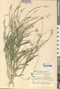
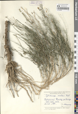
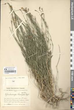
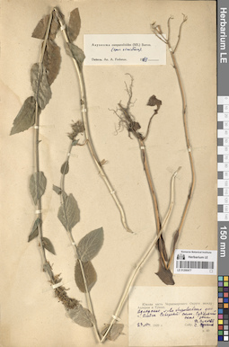
LE 01290359
Additional identifications: Asyneuma attenuatum (Franch.) Bornm. det. Kamelin, Rudolph Vladimirovich; Asyneuma canescens (Waldst. & Kit.) Griseb. & Schenk Field collecting number: 564. Collection date: 01.08.1970. Groups of specimens: Образцы сектора Средней АзииOriginal label text:
Бадахшан, Андероб, долина Гарм-Чашма (левый берег) в 1 км над источником Гарм-Чашма. На поле. H = 2750 м.
Record creation: 2024-08-04, Daria Yudova, PhotoScan D2.Citation: Specimen LE 01290359 // Virtual herbarium of Komarov Botanical Institute RAS — http://re.herbariumle.ru/01290359№ 564
1.VIII.1970
Султанов С.
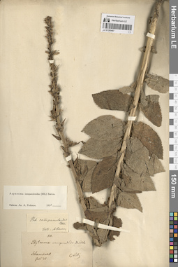
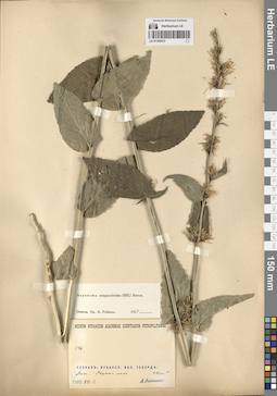
LE 01290487
Asyneuma campanuloides (M. Bieb. ex Sims) Bornm. det. Fedorov, Andrey Aleksandrovich at 1954
Field collecting number: 50. Collection date: 07.1875. Groups of specimens: Образцы сектора Кавказа; Соглашение Минобрнауки №075-15-2021-1056Record creation: 2024-08-04, Daria Yudova, PhotoScan D2.Citation: Specimen LE 01290487 // Virtual herbarium of Komarov Botanical Institute RAS — http://re.herbariumle.ru/01290487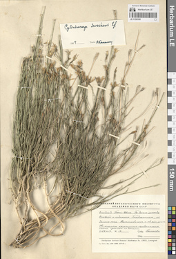
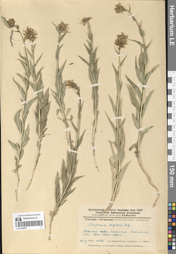
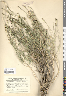
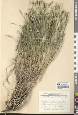
LE 01290358
Cylindrocarpa sewerzowii (Regel) Regel det. Kamelin, Rudolph Vladimirovich at 1964
Collectors: Pjataeva, A. D. Field collecting number: 12. Collection date: 17.06.1959. Administrative regions: KZ - South Kazakhstan - Tuerkistan Qalasy. Groups of specimens: Образцы сектора Средней АзииOriginal label text:Западный Тянь-Шань. По дороге между Орловкой и рудником Байджансаем, по долине реки Каттабугунь [Улькен-бугунь] и её западному притоку. На южном каменисто-щебенчатом склоне (дальше по долине).
Coordinates (geographic position): 43° 5′ 26.88″ N, 69° 55′ 9.27″ EComment: №12
17.VI.1959
Пятаева
Western Tien Shan. Along the road between Orlovka and the Baidzhansai mine, along the Kattabugun [= Ulken-Bugun] River valley and its western tributary. On the southern rocky-gravelly slope (further along the valley).
Record creation: 2024-08-04, Daria Yudova, PhotoScan D2.Citation: Specimen LE 01290358 // Virtual herbarium of Komarov Botanical Institute RAS — http://re.herbariumle.ru/01290358№12
17.06.1959
Coll. Pjataeva
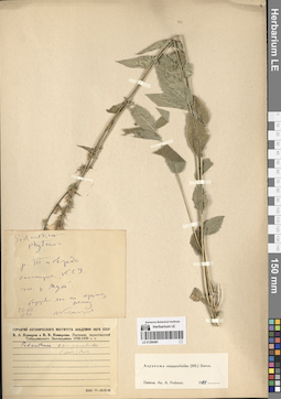
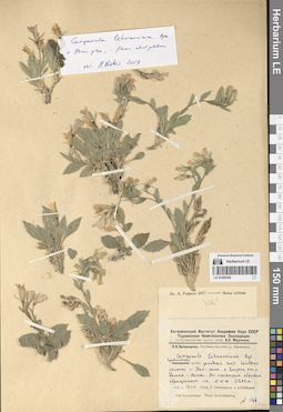
LE 01290486
Asyneuma campanuloides (M. Bieb. ex Sims) Bornm. det. Fedorov, Andrey Aleksandrovich at 1963
Collectors: Juzepczuk, Sergei Vasilievich; Vysokoostrovskaja, I. B.; Sergievskaja, Yekaterina Vladimirovna Field collecting number: 331. Collection date: 17.07.1954. Administrative regions: GE - Georgia. Groups of specimens: Образцы сектора Кавказа; Соглашение Минобрнауки №075-15-2021-1056Original label text:Грузинская ССР, окрестности города Бакуриани, южный склон горы Цхра-Цхаро, лужайки у верхней границы леса пониже Ахалкалакского шоссе.
Coordinates (geographic position): 41° 41′ 43.98″ N, 43° 30′ 42.24″ EComment: № 331
17.VII.1954
С. Юзепчук, И. Высокоостровская, Е. Сергиевская
Georgia, the vicinity of the city of Bakuriani, the southern slope of Mount Tskhra-Tskharo, lawns at the upper border of the forest below the Akhalkalaki highway.№ 331
Record creation: 2024-08-04, Daria Yudova, PhotoScan D2.Citation: Specimen LE 01290486 // Virtual herbarium of Komarov Botanical Institute RAS — http://re.herbariumle.ru/0129048617.07.1954
Coll. S. Juzepczuk, I. Vysokoostrovskaja, E. Sergievskaja
LE 01290357
Cylindrocarpa sewerzowii (Regel) Regel det. Kamelin, Rudolph Vladimirovich
Collectors: Kamelin, Rudolph Vladimirovich Field collecting number: 1554. Collection date: 06.07.1974. Administrative regions: KZ - Kazakhstan. Groups of specimens: Образцы сектора Средней АзииOriginal label text:Казахстан, Сырдарьинский Каратау, центр, массив Мынджилке, ущелье Райс, скалы в выемке с Dryopteris.
Coordinates (geographic position): 43° 47′ 6.64″ N, 68° 42′ 41.74″ EComment: № 1554
6.VII.1974
Р. Камелин
Kazakhstan, The Syrdariyinskiy Karatau Range, the Central Karatau Mountains, Myndzhilke, Rays gorge, rocks in a depression with Dryopteris.
Record creation: 2024-08-04, Daria Yudova, PhotoScan D2.Citation: Specimen LE 01290357 // Virtual herbarium of Komarov Botanical Institute RAS — http://re.herbariumle.ru/01290357№ 1554
06.07.1974
Coll. R. Kamelin
LE 01290485
Asyneuma campanuloides (M. Bieb. ex Sims) Bornm. det. Fedorov, Andrey Aleksandrovich at 1963
Collectors: Vassiljev, Igor V. Collection date: 08.07.1951. Administrative regions: RU - Respublika Adygeya. Groups of specimens: Образцы сектора Кавказа; Соглашение Минобрнауки №075-15-2021-1056Original label text:Пастбище Абаго. Субальпийский луг. 1800 м.
Coordinates (geographic position): 44° 30′ 51.84″ N, 40° 15′ 33.12″ E 1800 m a.s.l.Comment: 8.VII.1951
Иг. В. Васильев
Adygeya, Abago pasture. Subalpine meadow. 1800 m.
8.07.1951
Сoll. Ig. V. Vassiljev
LE 01290356
Cylindrocarpa sewerzowii (Regel) Regel det. Kamelin, Rudolph Vladimirovich
Collectors: Kamelin, Rudolph Vladimirovich Field collecting number: 5-a. Collection date: 04.07.1973. Administrative regions: KZ - Kazakhstan. Groups of specimens: Образцы сектора Средней АзииOriginal label text:Сырдарьинский Каратау, ущелье Алма-сай в восточной части (бассейн озера Бийликуль), щебнистые скалы.
4.07.1973Р. Камелин
Syr Darya Karatau, Alma-sai gorge in the eastern part (Biylikul Lake basin), rubble rocks.
Record creation: 2024-08-04, Daria Yudova, PhotoScan D2.Citation: Specimen LE 01290356 // Virtual herbarium of Komarov Botanical Institute RAS — http://re.herbariumle.ru/012903564.07.1973
Coll. R. Kamelin
LE 01290484
Asyneuma campanuloides (M. Bieb. ex Sims) Bornm. det. Fedorov, Andrey Aleksandrovich at 1963
Collectors: Schelkownikow, Alexandr Bebutovicz; Kara-Murza, Evelina Nikitichna Collection date: 13.07.1927. Administrative regions: AM - Armenia. Groups of specimens: Образцы сектора Кавказа; Соглашение Минобрнауки №075-15-2021-1056Original label text:Лес в верховьях реки Марса-чай [= Тарса-чай, Гетик], за Чубухлинским перевалом.
Coordinates (geographic position): 40° 40′ 11.94″ N, 45° 14′ 45.91″ EComment: 13.VII.1927
A. Schelkovnikov et E. Kara-Murza
Armenia. Forest in the upper reaches of the Tarsa-chay [= Getik] river, beyond the Chubukhlinsky pass.
Record creation: 2024-08-04, Daria Yudova, PhotoScan D2.Citation: Specimen LE 01290484 // Virtual herbarium of Komarov Botanical Institute RAS — http://re.herbariumle.ru/0129048413.07.1927
Coll. A. Schelkovnikov, E. Kara-Murza
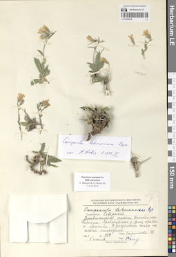
LE 01290355
Cylindrocarpa sewerzowii (Regel) Regel det. Kamelin, Rudolph Vladimirovich
Collectors: Kamelin, Rudolph Vladimirovich Field collecting number: 687. Collection date: 18.07.1970. Administrative regions: KZ - Zhambyl Oblysy. Groups of specimens: Образцы сектора Средней АзииOriginal label text:Сырдарьинский Каратау, ущелье Беркара, средняя часть, осыпь.
Coordinates (geographic position): 42° 54′ 11.64″ N, 70° 37′ 6.11″ EComment: № 687
18.07.1970
Р. Камелин
Syr Darya Karatau, Berkara gorge, middle part, scree.
Record creation: 2024-08-04, Daria Yudova, PhotoScan D2.Citation: Specimen LE 01290355 // Virtual herbarium of Komarov Botanical Institute RAS — http://re.herbariumle.ru/01290355№ 687
18.07.1970
Coll. R. Kamelin
LE 01290483
Asyneuma campanuloides (M. Bieb. ex Sims) Bornm. det. Fedorov, Andrey Aleksandrovich at 1963
Collection date: 03.07.1896. Administrative regions: RU - Stavropol'skiy Kray. Groups of specimens: Образцы сектора Кавказа; Соглашение Минобрнауки №075-15-2021-1056Original label text:96.VII.3 Пятигорск.
Coordinates (geographic position): 44° 4′ 18.06″ N, 43° 3′ 20.24″ EComment: Stavropol'skiy Kray, Pyatigorsk.
Record creation: 2024-08-04, Daria Yudova, PhotoScan D2.Citation: Specimen LE 01290483 // Virtual herbarium of Komarov Botanical Institute RAS — http://re.herbariumle.ru/0129048303.07.1896
LE 01290354
Cylindrocarpa sewerzowii (Regel) Regel det. Kamelin, Rudolph Vladimirovich
Collectors: Kamelin, Rudolph Vladimirovich Collection date: 07.07.1971. Administrative regions: KZ - Kazakhstan. Groups of specimens: Образцы сектора Средней АзииOriginal label text:Kasachstania, Karatau orientalis, regio Saj-assu, in shistosis.
Record creation: 2024-08-04, Daria Yudova, PhotoScan D2.Citation: Specimen LE 01290354 // Virtual herbarium of Komarov Botanical Institute RAS — http://re.herbariumle.ru/012903547.07.1971
R. Kamelin
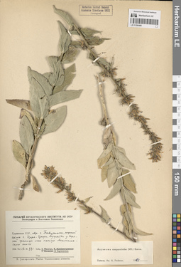
LE 01290482
Asyneuma campanuloides (M. Bieb. ex Sims) Bornm. det. Fedorov, Andrey Aleksandrovich at 1963
Collectors: Rodionova, M. E. Collection date: 27.07.1923. Administrative regions: RU - North Ossetia. Groups of specimens: Образцы сектора Кавказа; Соглашение Минобрнауки №075-15-2021-1056Original label text:Окрестности станции Ларс. Горреспублика.
Coordinates (geographic position): 42° 46′ 12.29″ N, 44° 37′ 46.34″ EComment: 27.VII.1923
М. Е. Родионова
North Ossetia, Verkhniy Lars.
Record creation: 2024-08-04, Daria Yudova, PhotoScan D2.Citation: Specimen LE 01290482 // Virtual herbarium of Komarov Botanical Institute RAS — http://re.herbariumle.ru/0129048227.07.1923
Coll. M. E. Rodionova
LE 01290353
Cylindrocarpa sewerzowii (Regel) Regel
Collectors: Minkwitz, Zinaida Alexandrovna Field collecting number: 268. Collection date: 23.05.1909. Administrative regions: KZ - Zhambyl Oblysy. Groups of specimens: Образцы сектора Средней АзииOriginal label text:Сыр-Дарьинская область. Аулие-атинский уезд. Ущелье Берк-кара (Каратау), нижняя часть склона одной из вершин ущелья.
Coordinates (geographic position): 42° 54′ 53.59″ N, 70° 37′ 16.14″ EComment: 23 мая 1909 г.
З. А. фон Минквиц
Syr Darya region. Aulie-Ata district. Berk-kara (Karatau) gorge, lower part of the slope of one of the gorge peaks.
23.05.1909
Coll. Z. A. Minkwitz
LE 01290481
Asyneuma campanuloides (M. Bieb. ex Sims) Bornm. det. Fedorov, Andrey Aleksandrovich at 1963
Collectors: Komarov, Vladimir Leontjevich Collection date: 20.07.1939. Administrative regions: RU - Karachayevo-Cherkesiya. Groups of specimens: Образцы сектора Кавказа; Соглашение Минобрнауки №075-15-2021-1056Original label text:Река Тиберда [Теберда], санаторий КСУ, долина реки Мухи [Муху], березовый лес по крутому склону.
Coordinates (geographic position): 43° 28′ 5.41″ N, 41° 43′ 19.71″ EComment: 20.VII.1939
В. Комаров
Karachayevo-Cherkesiya, Teberda River, KSU sanatorium, valley of the Mukhu River, birch forest on a steep slope.
20.07.1939
Coll. V. L. Komarov
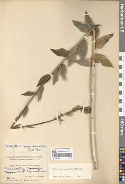
LE 01290352
Cylindrocarpa sewerzowii (Regel) Regel det. Ikonnikov-Galitzky, Nikolai Petrovic at 20.03.1936
Collectors: Abramov, Vladimir Alekseevich Абрамов, Владимир Алексеевич Collection date: 04.06.1905. Administrative regions: KG - Jalal-Abad oblast - Suzak. Expedition: В.А. Абрамов: Флора Западного Тянь-Шаня и Сыр-дарьинской области ()Groups of specimens: Образцы сектора Средней АзииOriginal label text:В.А. Абрамов: Флора Западного Тянь-Шаня и Сыр-дарьинской области
Coordinates (geographic position): 44° 0′ 51.47″ N, 68° 53′ 37″ EComment: Предгорье Каратавских гор между Сузаком и Челок-курганом.
4.VI.1905
V.A. Abramov: Flora of the Western Tien Shan and Syr Darya region
Record creation: 2024-08-04, Daria Yudova, PhotoScan D2.Citation: Specimen LE 01290352 // Virtual herbarium of Komarov Botanical Institute RAS — http://re.herbariumle.ru/01290352Foothills of the Karatau Mountains between Suzak and Chelok-kurgan.
4.06.1905
Coll. V. A. Abramov
LE 01290480
Asyneuma campanuloides (M. Bieb. ex Sims) Bornm. det. Fedorov, Andrey Aleksandrovich at 1963
Collectors: Juzepczuk, Sergei Vasilievich Field collecting number: 726. Collection date: 28.08.1923. Subregion: South Ossetia, Dzau district. Groups of specimens: Образцы сектора Кавказа; Соглашение Минобрнауки №075-15-2021-1056Original label text:№ 726
Coordinates (geographic position): 42° 27′ 34.37″ N, 43° 39′ 19.46″ EComment: In jugo Syrkh-leberte, in margine silvae frondosae.
28.VIII.1923
S. Juzepczuk
South Ossetia, Dzau district, the Syrkh-leberte mount.
Record creation: 2024-08-04, Daria Yudova, PhotoScan D2.Citation: Specimen LE 01290480 // Virtual herbarium of Komarov Botanical Institute RAS — http://re.herbariumle.ru/0129048028.08.1923
Coll. S. Juzepczuk
LE 01290351
Cylindrocarpa sewerzowii (Regel) Regel
Collectors: Pjataeva, A. D. Field collecting number: 314. Collection date: 03.06.1936. Administrative regions: KZ - Kazakhstan. Groups of specimens: Образцы сектора Средней АзииOriginal label text:Западный Тянь-Шань. Гора Каратау. Скалисто-каменистый западный склон урочища Кара-сай. h = 1100 м.
Comment: № 314
3.VI.1936
Пятаева
Western Tien Shan. Mount Karatau. The rocky western slope of the Kara-sai. h = 1100 m.
Record creation: 2024-08-04, Daria Yudova, PhotoScan D2.Citation: Specimen LE 01290351 // Virtual herbarium of Komarov Botanical Institute RAS — http://re.herbariumle.ru/01290351№ 314
3.06.1936
Coll. Pjataeva
LE 01290479
Asyneuma campanuloides (M. Bieb. ex Sims) Bornm. det. Fedorov, Andrey Aleksandrovich at 1963
Collectors: Juzepczuk, Sergei Vasilievich Field collecting number: 824. Collection date: 28.08.1923. Subregion: South Ossetia, Dzau district. Groups of specimens: Образцы сектора Кавказа; Соглашение Минобрнауки №075-15-2021-1056Original label text:№ 824
Coordinates (geographic position): 42° 27′ 34.37″ N, 43° 39′ 19.46″ EComment: In jugo Syrkh-leberte, in regione subalpina.
28.VIII.1923
S. Juzepczuk
South Ossetia, Dzau district, the Syrkh-leberte mount.
Record creation: 2024-08-04, Daria Yudova, PhotoScan D2.Citation: Specimen LE 01290479 // Virtual herbarium of Komarov Botanical Institute RAS — http://re.herbariumle.ru/0129047928.08.1923
Coll. S. Juzepczuk
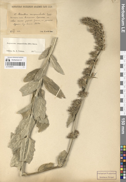
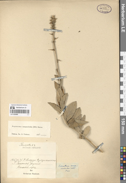
LE 01290350
Cylindrocarpa sewerzowii (Regel) Regel det. Fedorov, Andrey Aleksandrovich at 1961
Collectors: Botschantzev, Victor Petrovič Field collecting number: 410. Collection date: 17.06.1959. Administrative regions: KZ - South Kazakhstan - Tuerkistan Qalasy. Groups of specimens: Образцы сектора Средней АзииOriginal label text:Южный Казахстан. Хребет Каратау. В скалах над поселком Байджонсай.
Coordinates (geographic position): 43° 9′ 16.65″ N, 69° 55′ 31.73″ EComment: № 410
17.VI.1959
Бочанцев В. П.
Southern Kazakhstan. Karatau Ridge. In the rocks above the village of Baidzhonsai.
Record creation: 2024-08-04, Daria Yudova, PhotoScan D2.Citation: Specimen LE 01290350 // Virtual herbarium of Komarov Botanical Institute RAS — http://re.herbariumle.ru/01290350№ 410
17.06.1959
Coll. V. P. Botschantzev
LE 01290478
Asyneuma campanuloides (M. Bieb. ex Sims) Bornm. det. Fedorov, Andrey Aleksandrovich at 1963
Collectors: Dmitrieva, Aleksandra Alekseevna Collection date: 13.07.1951. Administrative regions: GE - Georgia. Groups of specimens: Образцы сектора Кавказа; Соглашение Минобрнауки №075-15-2021-1056Original label text:Аджария, юго-восточная часть Хулойского района, яйлы [Соры Чоир, (Сарычай?)]. Субальпийский разнотравный луг с чемерицей.
Comment: 13.VII.1951
А. Дмитриева
Georgia. Adjara, south-eastern part of the Khuloi region, yayly [Sory Choir, (Sarychay?)]. Subalpine forb meadow with hellebore.
Record creation: 2024-08-04, Daria Yudova, PhotoScan D2.Citation: Specimen LE 01290478 // Virtual herbarium of Komarov Botanical Institute RAS — http://re.herbariumle.ru/0129047813.07.1951
Coll. A. Dmitrieva
LE 01290349
Groups of specimens: Образцы сектора Средней АзииRecord creation: 2024-08-04, Daria Yudova, PhotoScan D2.Citation: Specimen LE 01290349 // Virtual herbarium of Komarov Botanical Institute RAS — http://re.herbariumle.ru/01290349
LE 01290477
Asyneuma campanuloides (M. Bieb. ex Sims) Bornm. det. Fedorov, Andrey Aleksandrovich at 1963
Collectors: Sukaczev, Vladimir Nikolajevich; Sokolov, Sergey Yakovlevich Collection date: 23.08.1929. Administrative regions: RU - Krasnodarskiy Kray. Groups of specimens: Образцы сектора Кавказа; Соглашение Минобрнауки №075-15-2021-1056Original label text:Южная часть Черноморского Округа между Адлером и Туапсе.
Coordinates (geographic position): 43° 37′ 40.6″ N, 40° 17′ 13″ EComment: Адлерское лесничество, Муравьевская дача, гора Аибга. Северный склон. Субальпийская зона.
23.VIII.1929
В. Сукачев, С. Соколов
Krasnodarskiy Kray, Mount Aibga. Northern slope. Subalpine zone.
Record creation: 2024-08-04, Daria Yudova, PhotoScan D2.Citation: Specimen LE 01290477 // Virtual herbarium of Komarov Botanical Institute RAS — http://re.herbariumle.ru/0129047723.08.1929
Coll. V. Sukaczev, S. Sokolov
LE 01290348
Groups of specimens: Образцы сектора Средней АзииRecord creation: 2024-08-04, Daria Yudova, PhotoScan D2.Citation: Specimen LE 01290348 // Virtual herbarium of Komarov Botanical Institute RAS — http://re.herbariumle.ru/01290348
LE 01290476
Asyneuma campanuloides (M. Bieb. ex Sims) Bornm. det. Fedorov, Andrey Aleksandrovich at 1964
Collectors: Marcowicz, Vasilii Vasilevicz Collection date: 10.07.1897. Administrative regions: RU - North Ossetia. Groups of specimens: Образцы сектора Кавказа; Соглашение Минобрнауки №075-15-2021-1056Original label text:Caucasus. Ossetia. In pratis agricis prope Mamison.
Coordinates (geographic position): 42° 39′ 37.93″ N, 43° 50′ 26.39″ ERecord creation: 2024-08-04, Daria Yudova, PhotoScan D2.Citation: Specimen LE 01290476 // Virtual herbarium of Komarov Botanical Institute RAS — http://re.herbariumle.ru/0129047610.VII.97
Marcowitch
LE 01290347
Groups of specimens: Образцы сектора Средней АзииRecord creation: 2024-08-04, Daria Yudova, PhotoScan D2.Citation: Specimen LE 01290347 // Virtual herbarium of Komarov Botanical Institute RAS — http://re.herbariumle.ru/01290347
LE 01290475
Asyneuma campanuloides (M. Bieb. ex Sims) Bornm. det. Fedorov, Andrey Aleksandrovich at 1954
Collectors: Busch, Elizaveta Aleksandrovna; Busch, Nikolai Adolfovich (Nikolaj Adolfowitsch) Collection date: 25.08.1925. Administrative regions: RU - Kabardino-Balkarskaya Respublika. Groups of specimens: Образцы сектора Кавказа; Соглашение Минобрнауки №075-15-2021-1056Original label text:Балкария, Сукан. Остатки березняка на левом склоне ущелья Сукана, на урочище Мусака-бау-баши. 2250 м.
Coordinates (geographic position): 2250 m a.s.l.Comment: 25.VIII.1925
Е. и Н. Буш
Balkaria, Sukan. Remains of a birch forest on the left slope of the Sukan gorge, on the Musaka-bau-bashi tract. 2250 m.
Record creation: 2024-08-04, Daria Yudova, PhotoScan D2.Citation: Specimen LE 01290475 // Virtual herbarium of Komarov Botanical Institute RAS — http://re.herbariumle.ru/0129047525.08.1925
Coll. E. Busch, N. Busch
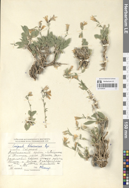
LE 01290346
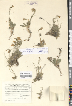
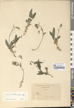
Campanula lehmanniana Bunge det. Kamelin, Rudolph Vladimirovich
Collectors: Kamelin, Rudolph Vladimirovich Collection date: 18.07.1965. Administrative regions: TJ - Tajikistan. Groups of specimens: Образцы сектора Средней АзииOriginal label text:Таджикистан, Фанские горы, озеро Кули-Калон, западная оконечность, скалы.
Coordinates (geographic position): 39° 15′ 13.24″ N, 68° 9′ 57.63″ EComment: 18.07.1965
Р. Камелин
Tajikistan, Fann Mountains, Kuli-Kalon Lake, western end, rocks.
Record creation: 2024-08-04, Daria Yudova, PhotoScan D2.Citation: Specimen LE 01290346 // Virtual herbarium of Komarov Botanical Institute RAS — http://re.herbariumle.ru/0129034618.07.1965
Coll. R. Kamelin
LE 01290474
Asyneuma campanuloides (M. Bieb. ex Sims) Bornm. det. Fedorov, Andrey Aleksandrovich at 1954
Collectors: Busch, Elizaveta Aleksandrovna; Busch, Nikolai Adolfovich (Nikolaj Adolfowitsch) Field collecting number: 50. Collection date: 24.08.1925. Administrative regions: RU - Kabardino-Balkarskaya Respublika. Groups of specimens: Образцы сектора Кавказа; Соглашение Минобрнауки №075-15-2021-1056Original label text:Балкария, Сукан. Субальпийский луг на урочище Архы. 2250 м.
Coordinates (geographic position): 42° 58′ 24.42″ N, 43° 26′ 31.6″ E 2250 m a.s.l.Comment: 24.VIII.1925
Е. и Н. Буш
Balkaria, Sukan. Subalpine meadow on the Arkhy. 2250 m.
Record creation: 2024-08-04, Daria Yudova, PhotoScan D2.Citation: Specimen LE 01290474 // Virtual herbarium of Komarov Botanical Institute RAS — http://re.herbariumle.ru/0129047424.08.1925
Coll. E. Busch, N. Busch
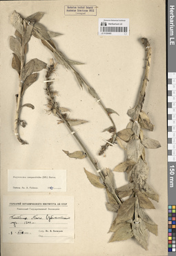
LE 01290345
Groups of specimens: Образцы сектора Средней АзииRecord creation: 2024-08-04, Daria Yudova, PhotoScan D2.Citation: Specimen LE 01290345 // Virtual herbarium of Komarov Botanical Institute RAS — http://re.herbariumle.ru/01290345
LE 01290473
Asyneuma campanuloides (M. Bieb. ex Sims) Bornm. det. Fedorov, Andrey Aleksandrovich at 1954
Collectors: Litvinov, Dimitri Ivanovich Field collecting number: 146. Collection date: 02.07.1905. Groups of specimens: Образцы сектора Кавказа; Соглашение Минобрнауки №075-15-2021-1056Original label text:146.
Comment: Кавказ. Кубанская область. Теберда.
[Даш].Опушки леса.
1905.VII.2
Д. Литвинов
146. Caucasus. Kuban region. Teberda. [Dash]. Forest edges.
Record creation: 2024-08-04, Daria Yudova, PhotoScan D2.Citation: Specimen LE 01290473 // Virtual herbarium of Komarov Botanical Institute RAS — http://re.herbariumle.ru/012904732.07.1905
Coll. D. Litvinov
LE 01290344
Groups of specimens: Образцы сектора Средней АзииRecord creation: 2024-08-04, Daria Yudova, PhotoScan D2.Citation: Specimen LE 01290344 // Virtual herbarium of Komarov Botanical Institute RAS — http://re.herbariumle.ru/01290344
LE 01290472
Asyneuma campanuloides (M. Bieb. ex Sims) Bornm. det. Fedorov, Andrey Aleksandrovich at 1954
Collectors: Busch, Elizaveta Aleksandrovna; Busch, Nikolai Adolfovich (Nikolaj Adolfowitsch) Collection date: 20.07.1911. Administrative regions: RU - North Ossetia. Groups of specimens: Образцы сектора Кавказа; Соглашение Минобрнауки №075-15-2021-1056Original label text:Субальпийский луг на Терской. 8000' - 8200'.
Coordinates (geographic position): 43° 43′ 2.26″ N, 44° 42′ 52.87″ EComment: 20.VII.1911
Е. А. и Н. А. Буш
Subalpine meadow on Terskaya. 8000' - 8200'.
Record creation: 2024-08-04, Daria Yudova, PhotoScan D2.Citation: Specimen LE 01290472 // Virtual herbarium of Komarov Botanical Institute RAS — http://re.herbariumle.ru/0129047220.07.1911
Coll. E. Busch, N. Busch
LE 01290343
Groups of specimens: Образцы сектора Средней АзииRecord creation: 2024-08-04, Daria Yudova, PhotoScan D2.Citation: Specimen LE 01290343 // Virtual herbarium of Komarov Botanical Institute RAS — http://re.herbariumle.ru/01290343
LE 01290471
Asyneuma campanuloides (M. Bieb. ex Sims) Bornm. det. Fedorov, Andrey Aleksandrovich at 1954
Collectors: Busch, Elizaveta Aleksandrovna; Busch, Nikolai Adolfovich (Nikolaj Adolfowitsch) Collection date: 20.07.1913. Administrative regions: RU - Kabardino-Balkarskaya Respublika. Groups of specimens: Образцы сектора Кавказа; Соглашение Минобрнауки №075-15-2021-1056Original label text:Терская область. Среди Betula raddeana на Башиль-ауз близ верхней границы березы, верховья Чегема. 6500' - 6800'.
Coordinates (geographic position): 43° 12′ 47.52″ N, 43° 0′ 52.08″ EComment: Kabardino-Balkaria.Among Betula raddeana on the Bashil-auz river, near the upper border of the birch, upper reaches of the Chegem river. 6500' - 6800'.
Record creation: 2024-08-04, Daria Yudova, PhotoScan D2.Citation: Specimen LE 01290471 // Virtual herbarium of Komarov Botanical Institute RAS — http://re.herbariumle.ru/0129047120.07.1913
Coll. E. Busch, N. Busch
LE 01290341
Groups of specimens: Образцы сектора Средней АзииRecord creation: 2024-08-04, Daria Yudova, PhotoScan D2.Citation: Specimen LE 01290341 // Virtual herbarium of Komarov Botanical Institute RAS — http://re.herbariumle.ru/01290341
LE 01290470
Asyneuma campanuloides (M. Bieb. ex Sims) Bornm. det. Fedorov, Andrey Aleksandrovich at 1954
Collectors: Busch, Elizaveta Aleksandrovna; Busch, Nikolai Adolfovich (Nikolaj Adolfowitsch) Collection date: 21.07.1930. Subregion: South Ossetia. Expedition: Юго-Осетинская экспедиция АН СССР ()Groups of specimens: Образцы сектора Кавказа; Соглашение Минобрнауки №075-15-2021-1056Original label text:Чапарухское ущелье. Сенокосный субальпийский луг близ Нижнего Чапаруха. 2100 м.
Coordinates (geographic position): 42° 23′ 31.71″ N, 44° 15′ 3.55″ E 2100 m a.s.l.Comment: 21.VII.1930
Е. и Н. Буш
South Ossetia. Chaparukh Gorge. Subalpine meadow near Nizhny Chaparukh. 2100 m.
Record creation: 2024-08-04, Daria Yudova, PhotoScan D2.Citation: Specimen LE 01290470 // Virtual herbarium of Komarov Botanical Institute RAS — http://re.herbariumle.ru/0129047021.07.1930
Coll. E. Busch, N. Busch
LE 01290340
Groups of specimens: Образцы сектора Средней АзииRecord creation: 2024-08-04, Daria Yudova, PhotoScan D2.Citation: Specimen LE 01290340 // Virtual herbarium of Komarov Botanical Institute RAS — http://re.herbariumle.ru/01290340
LE 01290469
Asyneuma campanuloides (M. Bieb. ex Sims) Bornm. det. Fedorov, Andrey Aleksandrovich at 1954
Collectors: Stuckenberg, Elisabeth Karlovna Field collecting number: 64. Collection date: 21.06.1912. Administrative regions: RU - Stavropol'skiy Kray. Groups of specimens: Образцы сектора Кавказа; Соглашение Минобрнауки №075-15-2021-1056Original label text:Терская область. Окрестности Ессентуков. Долина реки Подкумка. Заросли кустарников.
Coordinates (geographic position): 43° 59′ 45.51″ N, 42° 48′ 1.72″ EComment: № 64.
1912.VI.21
E. Штукенберг
Stavropol'skiy Kray, vicinity of the Yessentuki, valley of the Podkumok river.
Record creation: 2024-08-04, Daria Yudova, PhotoScan D2.Citation: Specimen LE 01290469 // Virtual herbarium of Komarov Botanical Institute RAS — http://re.herbariumle.ru/0129046922.07.1912
Coll. E. Stuckenberg
LE 01290339
Groups of specimens: Образцы сектора Средней АзииRecord creation: 2024-08-04, Daria Yudova, PhotoScan D2.Citation: Specimen LE 01290339 // Virtual herbarium of Komarov Botanical Institute RAS — http://re.herbariumle.ru/01290339
LE 01290468
Asyneuma campanuloides (M. Bieb. ex Sims) Bornm. det. Fedorov, Andrey Aleksandrovich at 1954
Collectors: Gomerov, K.E. Collection date: 25.07.1915. Administrative regions: GE - Abkhazia. Groups of specimens: Образцы сектора Кавказа; Соглашение Минобрнауки №075-15-2021-1056Original label text:Село Ажары [= Ажара] Сухумского округа. Гора Большая Футия [= Большая Хутыа]. Нижний луг.
Coordinates (geographic position): 43° 10′ 30.94″ N, 41° 48′ 47.03″ EComment: 25.VII.1915
Гомеров К. Е.
Abkhazia, the Azhara village, the Bolshaya Khutya mount.
Record creation: 2024-08-04, Daria Yudova, PhotoScan D2.Citation: Specimen LE 01290468 // Virtual herbarium of Komarov Botanical Institute RAS — http://re.herbariumle.ru/0129046825.07.1915
Coll. K. E. Gomerov
LE 01290338
Groups of specimens: Образцы сектора Средней АзииRecord creation: 2024-08-04, Daria Yudova, PhotoScan D2.Citation: Specimen LE 01290338 // Virtual herbarium of Komarov Botanical Institute RAS — http://re.herbariumle.ru/01290338
LE 01290467
Asyneuma campanuloides (M. Bieb. ex Sims) Bornm. det. Fedorov, Andrey Aleksandrovich at 1954
Collectors: Grubov, Valery Ivanovich; Ivanina, Lyudmila Ivanovna Collection date: 24.07.1945. Expedition: Кавказская комплексная экспедиция АН СССР (1945 -1946)Groups of specimens: Образцы сектора Кавказа; Соглашение Минобрнауки №075-15-2021-1056Original label text:Северный Кавказ. Бассейн реки Уруп.
Coordinates (geographic position): 1538 m a.s.l.Comment: Скалистый хребет. Граматуха. Вершина 1538. Луг на северном склоне.
24.VIII.1945
В. И. Грубов и Л. И. Иванина
North Caucasus. Basin of the Urup River. Skalisty ridge. Gramatukha. h = 1538 m.
Record creation: 2024-08-04, Daria Yudova, PhotoScan D2.Citation: Specimen LE 01290467 // Virtual herbarium of Komarov Botanical Institute RAS — http://re.herbariumle.ru/0129046724.08.1945
Coll. V. I. Grubov, L. I. Ivanina
LE 01290337
Groups of specimens: Образцы сектора Средней АзииRecord creation: 2024-08-04, Daria Yudova, PhotoScan D2.Citation: Specimen LE 01290337 // Virtual herbarium of Komarov Botanical Institute RAS — http://re.herbariumle.ru/01290337
LE 01290466
Asyneuma campanuloides (M. Bieb. ex Sims) Bornm. det. Fedorov, Andrey Aleksandrovich at 1954
Collectors: Grubov, Valery Ivanovich; Ivanina, Lyudmila Ivanovna Collection date: 23.08.1945. Expedition: Кавказская комплексная экспедиция АН СССР (1945 -1946)Groups of specimens: Образцы сектора Кавказа; Соглашение Минобрнауки №075-15-2021-1056Original label text:Северный Кавказ. Бассейн реки Уруп.
Coordinates (geographic position): 43° 42′ 40.97″ N, 41° 6′ 50.87″ E 2400 m a.s.l.Comment: Передовой хребет. Чилик-скала. Южный склон. Среди камней в западне. 2400 м.
23.VIII.1945
В. И. Грубов и Л. И. Иванина
North Caucasus. Basin of the Urup River. Front Range. Chilik rock. Southern slope. Among the stones in a trap. 2400 m.
Record creation: 2024-08-04, Daria Yudova, PhotoScan D2.Citation: Specimen LE 01290466 // Virtual herbarium of Komarov Botanical Institute RAS — http://re.herbariumle.ru/0129046623.08.1945
Coll. V. I. Grubov, L. I. Ivanina