View
Add
Copy
Edit
Delete
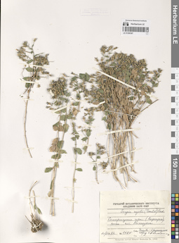
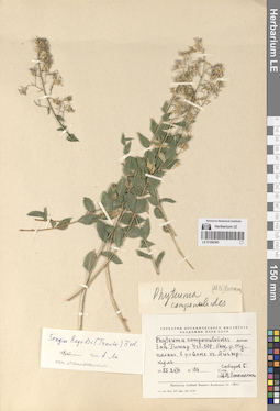
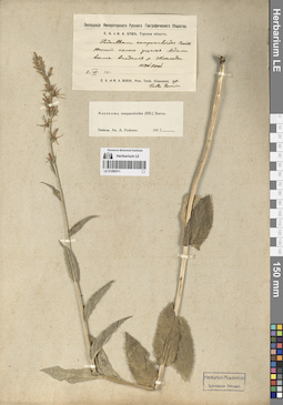
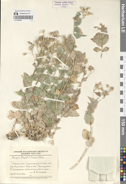
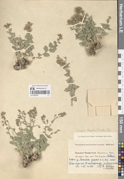
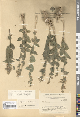
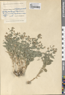
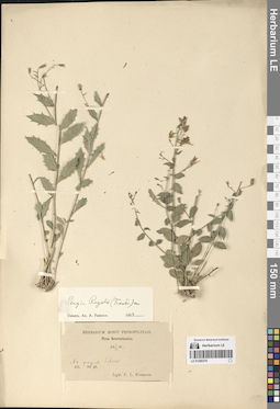
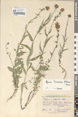
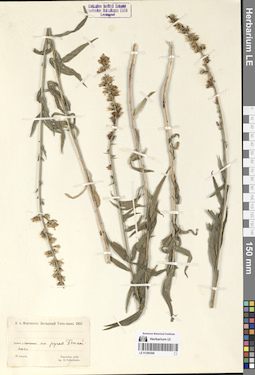
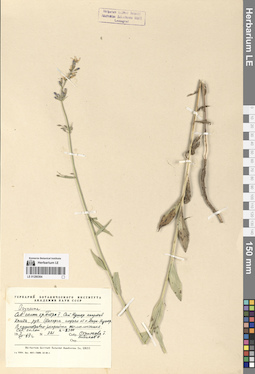
LE 01290387
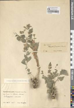
Sergia regelii (Trautv.) Fed.
Collectors: Kamelin, Rudolph Vladimirovich Field collecting number: 1565. Collection date: 17.06.1982. Administrative regions: UZ - Uzbekistan. Groups of specimens: Образцы сектора Средней АзииOriginal label text:Самаркандские горы (Кыркарча) ниже поселка Аманкутан.
Comment: № 1565
17.VI.1982
Закавк.-Среднеазиат. отряд Р. В. Камелин и др.
Samarkand Mountains (Kyrkarcha) below the village of Amankutan.
Record creation: 2024-08-04, Daria Yudova, PhotoScan D2.Citation: Specimen LE 01290387 // Virtual herbarium of Komarov Botanical Institute RAS — http://re.herbariumle.ru/01290387№ 1565
17.06.1982
Coll. R.V. Kamelin et al.
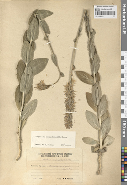
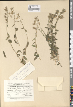
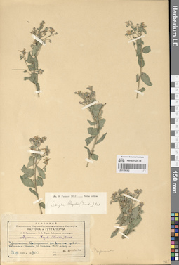
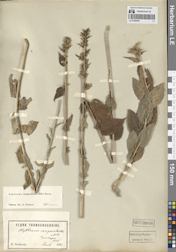
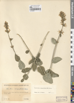
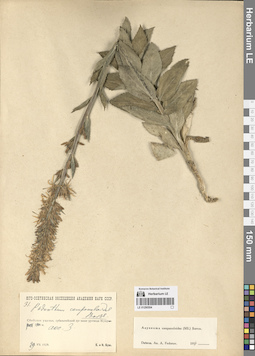
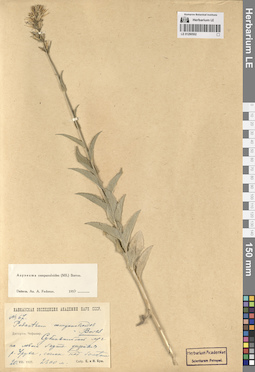
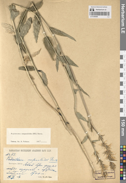
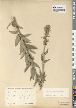
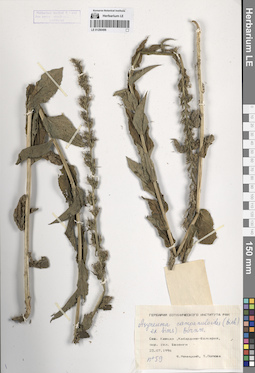
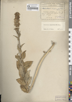
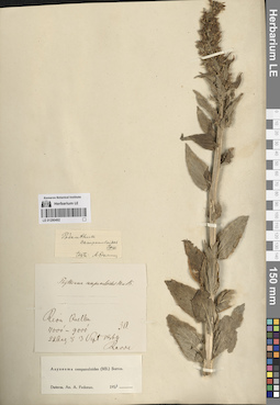
LE 01290515
Asyneuma campanuloides (M. Bieb. ex Sims) Bornm. det. Fedorov, Andrey Aleksandrovich at 1954
Collectors: Abramov, Ivan Ivanovich Collection date: 21.07.1938. Subregion: South Ossetia, Dzau district. Groups of specimens: Образцы сектора Кавказа; Соглашение Минобрнауки №075-15-2021-1056Original label text:Местность Эрмани. Субальпийский луг на склоне выше села Эдис.
Coordinates (geographic position): 42° 32′ 14.18″ N, 44° 14′ 9.2″ EComment: 21.VII.1938 г.
И. И. Абрамов
Ermani area. Subalpine meadow on the slope above the village of Edis.
Record creation: 2024-08-04, Daria Yudova, PhotoScan D2.Citation: Specimen LE 01290515 // Virtual herbarium of Komarov Botanical Institute RAS — http://re.herbariumle.ru/0129051521.07.1938
Coll. I. I. Abramov
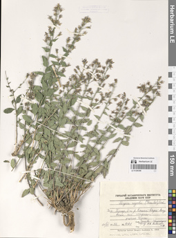
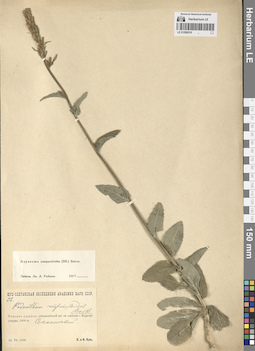
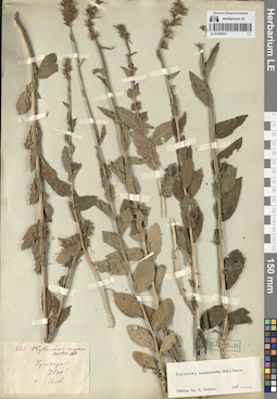
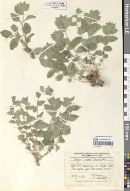
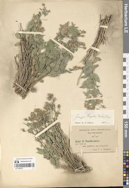
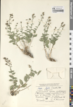
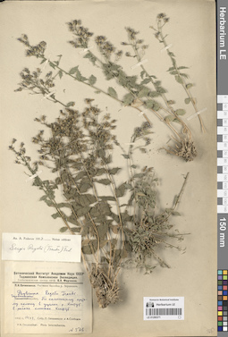
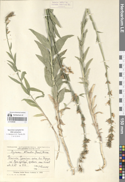
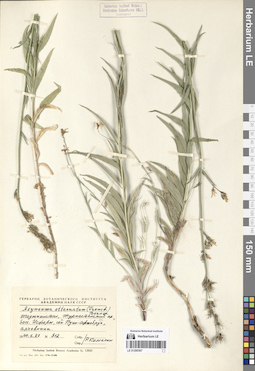
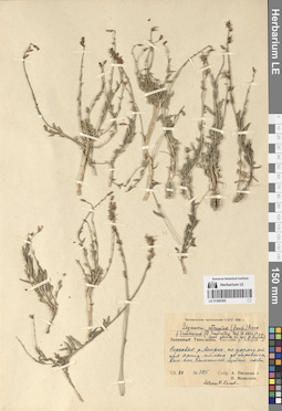
LE 01290386
Sergia regelii (Trautv.) Fed.
Field collecting number: 1021. Collection date: 11.06.1982. Administrative regions: UZ - Uzbekistan. Groups of specimens: Образцы сектора Средней АзииOriginal label text:Западный Гиссар, бассейн рек Кашка-Дарья-Аксу выше поселка Мираки, ущелье Чаккы.
Coordinates (geographic position): 39° 1′ 35.42″ N, 67° 11′ 37.59″ EComment: № 1021
11.VI.1982
Закавказско-Среднеазиатский отряд, Р. В. Камелин и др.
Western Gissar, the Kashka-Darya-Aksu river basin above the village of Miraki, the Chakky gorge.
№ 1021
11.06.1982
Coll. Transcaucasian-Central Asian detachment, R.V. Kamelin et al.
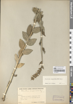
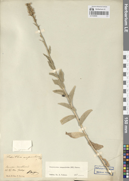
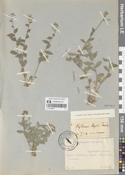
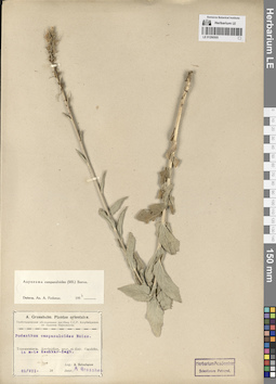
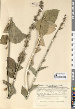
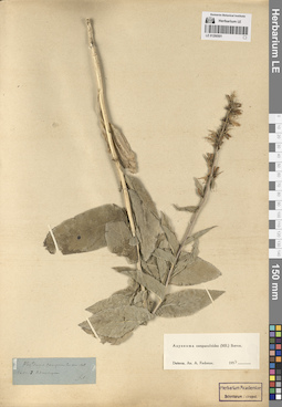
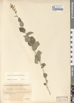
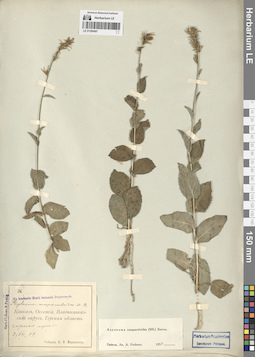
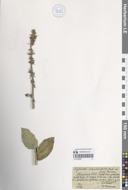
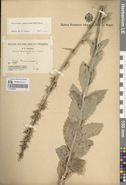
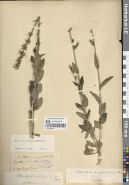
LE 01290514
Asyneuma campanuloides (M. Bieb. ex Sims) Bornm. det. Fedorov, Andrey Aleksandrovich at 1954
Collectors: Krylov, Porphyriy Nikitich; Steinberg, Elisabeth Ivanovna Collection date: 08.07.1916. Administrative regions: GE - Georgia. Groups of specimens: Образцы сектора Кавказа; Соглашение Минобрнауки №075-15-2021-1056Original label text:Кавказ. Тифлисская губерния. Горийский уезд. Имеретинские холмы между селом Бакуриани и горой Цхра-Цхаро, луга на склонах.
Coordinates (geographic position): 41° 43′ 8.44″ N, 43° 31′ 43.09″ EComment: 8 июля 1916 г.
П. Н. Крылов, Е. И. Штейнберг
Georgia. Imereti hills between the village of Bakuriani and Mount Tskhra-Tskharo, meadows on the slopes.
Record creation: 2024-08-04, Daria Yudova, PhotoScan D2.Citation: Specimen LE 01290514 // Virtual herbarium of Komarov Botanical Institute RAS — http://re.herbariumle.ru/0129051408.07.1916
Coll. P. N. Krylov, E. I. Steinberg
LE 01290385
Sergia regelii (Trautv.) Fed.
Collectors: Sabirov B.; Vassilczenko, Ivan Tikhonovich Field collecting number: 136. Collection date: 02.08.1955. Administrative regions: UZ - Uzbekistan. Groups of specimens: Образцы сектора Средней АзииOriginal label text:Западный Гиссар, Узбекская ССР. Бассейн реки Тупаланг, в районе озера Айгыр-Куль.
Coordinates (geographic position): 38° 54′ 51.46″ N, 67° 56′ 1.51″ EComment: № 136
2.VIII.1955
Сабиров, Васильченко
Western Gissar, Uzbekistan. Tupalang River basin, in the area of Lake Aygyr-Kul.
№ 136
2.08.1955
Coll. B. Sabirov, I. T. Vassilczenko

LE 01290513
Asyneuma campanuloides (M. Bieb. ex Sims) Bornm. det. Fedorov, Andrey Aleksandrovich at 1954
Collectors: Busch, Elizaveta Aleksandrovna; Busch, Nikolai Adolfovich (Nikolaj Adolfowitsch) Collection date: 12.08.1925. Administrative regions: RU - North Ossetia. Groups of specimens: Образцы сектора Кавказа; Соглашение Минобрнауки №075-15-2021-1056Original label text:Дигория. Левый склон Карагомского ущелья, покрытый широколиственными породами и сосной, на месте бывшего сосняка. 1650 - 1680 м.
Coordinates (geographic position): 42° 51′ 5.97″ N, 43° 42′ 5.26″ EComment: 12.VIII.1925
Е. и Н. Буш
Digoria. The left slope of the Karagom gorge, covered with broad-leaved trees and pine, on the site of a former pine forest. 1650 - 1680 m.
Record creation: 2024-08-04, Daria Yudova, PhotoScan D2.Citation: Specimen LE 01290513 // Virtual herbarium of Komarov Botanical Institute RAS — http://re.herbariumle.ru/0129051312.08.1925
Coll. E. Busch, N. Busch
LE 01290384
Sergia regelii (Trautv.) Fed.
Collectors: Sabirov B.; Vassilczenko, Ivan Tikhonovich Field collecting number: 136. Collection date: 02.08.1955. Administrative regions: UZ - Uzbekistan. Groups of specimens: Образцы сектора Средней АзииOriginal label text:Западный Гиссар, Узбекская ССР. Бассейн реки Тупаланг, в районе озера Айгыр-Куль.
Coordinates (geographic position): 38° 54′ 51.46″ N, 67° 56′ 1.51″ EComment: № 136
2.VIII.1955
Сабиров, Васильченко
Western Gissar, Uzbekistan. Tupalang River basin, in the area of Lake Aygyr-Kul.
№ 136
2.08.1955
Coll. Sabirov, Vassilczenko
LE 01290512
Asyneuma campanuloides (M. Bieb. ex Sims) Bornm. det. Fedorov, Andrey Aleksandrovich at 1956
Collectors: Busch, Elizaveta Aleksandrovna; Busch, Nikolai Adolfovich (Nikolaj Adolfowitsch) Collection date: 29.06.1925. Administrative regions: RU - Kabardino-Balkarskaya Respublika. Groups of specimens: Образцы сектора Кавказа; Соглашение Минобрнауки №075-15-2021-1056Original label text:Балкария, Рцывашки. Субальпийский луг на урочище Урта-тала при впадении Цуралан-кол в Рцывашку. 2018 м.
Coordinates (geographic position): 2018 m a.s.l.Comment: 29.VI.1925
Е. и Н. Буш
Balkaria, Rtsyvashki. Subalpine meadow on the Urta-tala at the confluence of the Tsuralan-kol and the Rtsyvashka. 2018 m.
Record creation: 2024-08-04, Daria Yudova, PhotoScan D2.Citation: Specimen LE 01290512 // Virtual herbarium of Komarov Botanical Institute RAS — http://re.herbariumle.ru/0129051229.06.1925
Coll. E. Busch, N. Busch
LE 01290383
Sergia regelii (Trautv.) Fed. det. Kamelin, Rudolph Vladimirovich
Collectors: Kamelin, Rudolph Vladimirovich; Mikhajlova, Marina Аntonovna; Mishenkova, Antonina Petrovna Field collecting number: 227. Collection date: 14.04.1977. Administrative regions: UZ - Qashqadaryo Province. Groups of specimens: Образцы сектора Средней АзииOriginal label text:Самаркандские горы, перевал Тахта-карача, подножье перевала, сланцевые горы.
Coordinates (geographic position): 39° 15′ 11.13″ N, 66° 54′ 53.48″ EComment: № 227
14.IV.1977
Р. В. Камелин, М. А. Михайлова, А. П. Мишенкова
Samarkand mountains, Takhta-karacha pass, foot of the pass, slate mountains.
Record creation: 2024-08-04, Daria Yudova, PhotoScan D2.Citation: Specimen LE 01290383 // Virtual herbarium of Komarov Botanical Institute RAS — http://re.herbariumle.ru/01290383№ 227
14.04.1977
Coll. R. V. Kamelin, M. A. Mikhailova, A. P. Mishenkova
LE 01290511
Asyneuma campanuloides (M. Bieb. ex Sims) Bornm. det. Fedorov, Andrey Aleksandrovich at 1954
Collectors: Busch, Elizaveta Aleksandrovna; Busch, Nikolai Adolfovich (Nikolaj Adolfowitsch) Collection date: 02.07.1911. Administrative regions: RU - Kabardino-Balkarskaya Respublika. Groups of specimens: Образцы сектора Кавказа; Соглашение Минобрнауки №075-15-2021-1056Original label text:Южный склон ущелья Адыла [= Адылсу] выше впадения реки Шхельды. 6500' - 7000'.
Coordinates (geographic position): 43° 13′ 40.23″ N, 42° 39′ 26.04″ EComment: 2.VII.1911
Е. А. Буш, Н. А. Буш
The southern slope of the Adyl [=Adylsu] gorge, above the confluence of the Shkhelda River. 6500' - 7000'.
Record creation: 2024-08-04, Daria Yudova, PhotoScan D2.Citation: Specimen LE 01290511 // Virtual herbarium of Komarov Botanical Institute RAS — http://re.herbariumle.ru/012905112.07.1911
Coll. N. Busch, E. Busch
LE 01290382
Sergia regelii (Trautv.) Fed.
Collectors: Jarmolenko, Alexander Viktorovich Field collecting number: 400. Collection date: 28.08.1931. Administrative regions: UZ - Uzbekistan. Groups of specimens: Образцы сектора Средней АзииOriginal label text:Узбекистан. Байсунский район. Вершина хребта Кетмень-чапты, по скалам, 3435 м н.у.м.
Coordinates (geographic position): 38° 28′ 7.87″ N, 67° 25′ 0.26″ EComment: № 400
28.VIII.1931
A. Jarmolenko
Uzbekistan. Baysun district. The summit of the Ketmen-chapty ridge, on the rocks, 3435 m above sea level.
Record creation: 2024-08-04, Daria Yudova, PhotoScan D2.Citation: Specimen LE 01290382 // Virtual herbarium of Komarov Botanical Institute RAS — http://re.herbariumle.ru/01290382№ 400
28.08.1931
Coll. A. Jarmolenko
LE 01290510
Asyneuma campanuloides (M. Bieb. ex Sims) Bornm. det. Fedorov, Andrey Aleksandrovich at 1954
Collectors: Busch, Elizaveta Aleksandrovna; Busch, Nikolai Adolfovich (Nikolaj Adolfowitsch) Field collecting number: 22. Collection date: 23.07.1929. Administrative regions: RU - North Ossetia. Expedition: Юго-Осетинская экспедиция АН СССР ()Groups of specimens: Образцы сектора Кавказа; Соглашение Минобрнауки №075-15-2021-1056Original label text:Рокское ущелье, субальпийский луг на вершине горы Кадисэр-угардан. 2400 м.
Coordinates (geographic position): 42° 36′ 53.91″ N, 44° 9′ 33.76″ E 2400 m a.s.l.Comment: 23.VII.1929
Е. и Н. Буш
Ossetia. Roksky Gorge, subalpine meadow on the top of Mount Kadisar-Ugardan. 2400 m.
Record creation: 2024-08-04, Daria Yudova, PhotoScan D2.Citation: Specimen LE 01290510 // Virtual herbarium of Komarov Botanical Institute RAS — http://re.herbariumle.ru/0129051023.07.1929
Coll. E. Busch, N. Busch

LE 01290381
Sergia regelii (Trautv.) Fed. det. Fedorov, Andrey Aleksandrovich at 1954
Collectors: Kudrjaschev, Serafim Nikovajevich; Sumnevich, Georgy Prokopyevich Field collecting number: 862. Collection date: 11.07.1938. Administrative regions: UZ - Qashqadaryo Province. Groups of specimens: Образцы сектора Средней АзииOriginal label text:Бассейн реки Кашка-Дарьи. Западная часть Зеравшанского хребта. Южные склоны. Скалы на гребне увала между Хазаляк и Аякчи.
Coordinates (geographic position): 39° 16′ 26.77″ N, 66° 44′ 57.19″ EComment: № 862
11.VII.1938
С. Н. Кудряшев, Г. П. Сумневич
The Kashka-Darya River basin. The western part of the Zeravshan Range. Southern slopes. Rocks on the ridge between Khazalyak and Ayakchi.
№ 862
11.07.1938
Coll. S. N. Kudrjaschev, G. P. Sumnevich
LE 01290509
Asyneuma campanuloides (M. Bieb. ex Sims) Bornm. det. Fedorov, Andrey Aleksandrovich at 1954
Collectors: Puring, Nicolai Ivanovich Collection date: 15.07.1894. Administrative regions: RU - Dagestan. Groups of specimens: Образцы сектора Кавказа; Соглашение Минобрнауки №075-15-2021-1056Original label text:Салты [= Салта]. Дагестан.
7000 ф.
15.VII.1894Н. Пуринг
Dagestan. The Salta village.
Record creation: 2024-08-04, Daria Yudova, PhotoScan D2.Citation: Specimen LE 01290509 // Virtual herbarium of Komarov Botanical Institute RAS — http://re.herbariumle.ru/012905097000'.
15.07.1894
Coll. N. Puring
LE 01290380
Sergia regelii (Trautv.) Fed.
Collectors: Botschantzev, Victor Petrovič Field collecting number: 152. Collection date: 15.10.1970. Administrative regions: UZ - Uzbekistan. Groups of specimens: Образцы сектора Средней АзииOriginal label text:Узбекистан. Сурхандарьинская обл. Хр. Кугитанг. Окрестности кишлака Тангидувал. В трещинах известняковых скал.
Coordinates (geographic position): 37° 58′ 0″ N, 66° 44′ 0″ EComment: № 152
15.X.1970
В. Бочанцев
Uzbekistan. Surkhandarya region. Kugitang Ridge. The outskirts of the village of Tangiduval. In the cracks of limestone rocks.
№ 152
15.10.1970
Coll. V. Botschantzev
LE 01290508
Asyneuma campanuloides (M. Bieb. ex Sims) Bornm. det. Fedorov, Andrey Aleksandrovich at 1954
Collectors: Sredinsky, Nicolai Konstantinovich Collection date: 07.1873. Administrative regions: GE - Georgia. Groups of specimens: Образцы сектора Кавказа; Соглашение Минобрнауки №075-15-2021-1056Original label text:Чутхаро
7200'
Июль 1873
N. Sredinsky
Georgia. The Chutkharo mount.
7200'
July 1873
N. Sredinsky
LE 01290379
Sergia regelii (Trautv.) Fed.
Collectors: Popov, Mikhail Grigorevich (Popow) Collection date: 28.06.1927. Administrative regions: UZ - Uzbekistan. Groups of specimens: Образцы сектора Средней АзииOriginal label text:Ширабадская долина. Гребень Кугитанга против села Кизил-алма, в [теньге].
Coordinates (geographic position): 37° 53′ 42.44″ N, 66° 40′ 5.79″ EComment: 28/VI - 27 г.
М. Г. Попов
Shirabad Valley. Kugitang Ridge against the Kizil-alma Village.
28.06.1927
Coll. M. G. Popov
LE 01290507
Asyneuma campanuloides (M. Bieb. ex Sims) Bornm. det. Fedorov, Andrey Aleksandrovich at 1954
Field collecting number: 223. Administrative regions: GE - Georgia. Groups of specimens: Образцы сектора Кавказа; Соглашение Минобрнауки №075-15-2021-1056Original label text:№ 223
Coordinates (geographic position): 42° 43′ 20.59″ N, 43° 10′ 9.34″ EComment: Чутхара
7200'
Июль
№ 223
Record creation: 2024-08-04, Daria Yudova, PhotoScan D2.Citation: Specimen LE 01290507 // Virtual herbarium of Komarov Botanical Institute RAS — http://re.herbariumle.ru/01290507Georgia. The Chutkharo mount.
7200'
July
LE 01290378
Sergia regelii (Trautv.) Fed.
Collectors: Botschantzev, Victor Petrovič; Butkov, Aleksandr Yakovlevich Field collecting number: 494. Collection date: 27.06.1936. Administrative regions: UZ - Uzbekistan. Groups of specimens: Образцы сектора Средней АзииOriginal label text:Западный Памиро-алай. Верховья реки Яккабаг-дарья. Окрестности кишлака Таш-Курган. Левый берег реки Яккабаг-дарья к З от кишлака Таш-Курган. В трещинах известняковых скал.
Coordinates (geographic position): 38° 56′ 11.83″ N, 66° 52′ 49.27″ EComment: № 494
27.VI.1936
В. Бочанцев, А. Ботков
Western Pamir-Alai. The upper reaches of the Yakkabag-Darya river. The outskirts of the Tash-Kurgan village. The left bank of the Yakkabag-Darya river to the west from the Tash-Kurgan village. In the cracks of limestone rocks.
Record creation: 2024-08-04, Daria Yudova, PhotoScan D2.Citation: Specimen LE 01290378 // Virtual herbarium of Komarov Botanical Institute RAS — http://re.herbariumle.ru/01290378№ 494
27.06.1936
Coll. V. Botschantzev, A. Butkov
LE 01290506
Asyneuma campanuloides (M. Bieb. ex Sims) Bornm. det. Fedorov, Andrey Aleksandrovich at 1954
Collectors: Busch, Elizaveta Aleksandrovna; Busch, Nikolai Adolfovich (Nikolaj Adolfowitsch) Collection date: 23.08.1930. Subregion: South Ossetia, Dzau district. Expedition: Юго-Осетинская экспедиция АН СССР ()Groups of specimens: Образцы сектора Кавказа; Соглашение Минобрнауки №075-15-2021-1056Original label text:Джомах [= Джомага, Дзомаг], ущелье Сомих, левый борт, сенокосный субальпийский луг. 2000 м.
Coordinates (geographic position): 42° 33′ 56.36″ N, 44° 2′ 35.71″ E 2000 m a.s.l.Comment: 23.VIII.1930
Е. и Н. Буш
Jomakh, Somikh gorge, left side, subalpine meadow. 2000 m.
Record creation: 2024-08-04, Daria Yudova, PhotoScan D2.Citation: Specimen LE 01290506 // Virtual herbarium of Komarov Botanical Institute RAS — http://re.herbariumle.ru/0129050623.08.1930
Coll. E. Busch, N. Busch
LE 01290377
Sergia regelii (Trautv.) Fed.
Collectors: Kamelin, Rudolph Vladimirovich; Makhmedov, A. M. Field collecting number: 64. Collection date: 13.05.1979. Administrative regions: UZ - Uzbekistan. Groups of specimens: Образцы сектора Средней АзииOriginal label text:Узбекская ССР, окрестности поселка Ургут, горы Ала-аярон, урочище Таш-иисык, скалы.
Coordinates (geographic position): 39° 21′ 23.41″ N, 67° 15′ 12.14″ EComment: № 64
13.5.1979
Камелин, Махмедов
Uzbek SSR, the vicinity of the village of Urgut, the Ala-ayaron mountains, the Tash-iisyk, rocks.
Record creation: 2024-08-04, Daria Yudova, PhotoScan D2.Citation: Specimen LE 01290377 // Virtual herbarium of Komarov Botanical Institute RAS — http://re.herbariumle.ru/01290377№ 64
13.05.1979
Coll. Kamelin, Makhmedov
LE 01290505
Asyneuma campanuloides (M. Bieb. ex Sims) Bornm. det. Fedorov, Andrey Aleksandrovich at 1954
Collectors: Doluchanov, Armen Georgievich Collection date: 21.07.1928. Administrative regions: AZ - Azerbaijan. Expedition: Геоботаническое обследование пастбищ ССР Азербайджана по заданию Наркомзема (1929)Groups of specimens: Образцы сектора Кавказа; Соглашение Минобрнауки №075-15-2021-1056Original label text:Transcaucasia, Azerbajdjan, prov. et distr. Gandzha, in m-te Koshkar-dagh.
Coordinates (geographic position): 40° 22′ 28.29″ N, 46° 0′ 12.23″ EComment: 21.VII.28
A. Doluchanov
Azerbaijan, the Koshkar mount.
Record creation: 2024-08-04, Daria Yudova, PhotoScan D2.Citation: Specimen LE 01290505 // Virtual herbarium of Komarov Botanical Institute RAS — http://re.herbariumle.ru/0129050521.07.1928
Coll. A. Doluchanov
LE 01290376
Sergia regelii (Trautv.) Fed.
Collectors: Drobow, Vasilii Petrovich Field collecting number: 16. Collection date: 25.06.1929. Administrative regions: UZ - Uzbekistan. Groups of specimens: Образцы сектора Средней АзииOriginal label text:Зеравшанский хребет. Северный склон. Окрестности кишлака Ургут. Гора Алла-яран. Северный склон.
Coordinates (geographic position): 39° 21′ 23.41″ N, 67° 15′ 12.14″ EComment: № 16
25.VI.1929
В. Дробов
Zeravshan Range. Northern slope. Environs of the Urgut village. Mount Alla-yaran. Northern slope.
Record creation: 2024-08-04, Daria Yudova, PhotoScan D2.Citation: Specimen LE 01290376 // Virtual herbarium of Komarov Botanical Institute RAS — http://re.herbariumle.ru/01290376№ 16
25.06.1929
Coll. V. Drobow
LE 01290504
Asyneuma campanuloides (M. Bieb. ex Sims) Bornm. det. Fedorov, Andrey Aleksandrovich at 1954
Collectors: Busch, Elizaveta Aleksandrovna; Busch, Nikolai Adolfovich (Nikolaj Adolfowitsch) Field collecting number: 31. Collection date: 29.07.1929. Subregion: South Ossetia, Dzau district. Expedition: Юго-Осетинская экспедиция АН СССР ()Groups of specimens: Образцы сектора Кавказа; Соглашение Минобрнауки №075-15-2021-1056Original label text:Сбийское ущелье, субальпийский луг выше урочища Жуар-рах. 2400 м. Асс. 3.
Coordinates (geographic position): 42° 33′ 59.53″ N, 44° 10′ 2.07″ E 2400 m a.s.l.Comment: 29.VII.1929
Е. и Н. Буш
Sbiyskoe gorge, subalpine meadow above the Zhuar-rah area. 2400 m.
Record creation: 2024-08-04, Daria Yudova, PhotoScan D2.Citation: Specimen LE 01290504 // Virtual herbarium of Komarov Botanical Institute RAS — http://re.herbariumle.ru/0129050429.07.1929
Coll. E. Busch, N. Busch
LE 01290375
Sergia regelii (Trautv.) Fed. det. Fedorov, Andrey Aleksandrovich at 1954
Collectors: Komarov, Vladimir Leontjevich Collection date: 07.1893. Administrative regions: UZ - Uzbekistan. Groups of specimens: Образцы сектора Средней АзииOriginal label text:Flora Seravschanica
Coordinates (geographic position): 39° 9′ 8.1″ N, 67° 33′ 10.86″ EComment: Schut (fl. Kaschka-daria).
Alt. 7000 pd.
Зона хвойных деревьев (Juniperus).
VII.1893
V. L. Komarov
Flora Seravschanica
Record creation: 2024-08-04, Daria Yudova, PhotoScan D2.Citation: Specimen LE 01290375 // Virtual herbarium of Komarov Botanical Institute RAS — http://re.herbariumle.ru/01290375The Schut village (the Kaschka-daria river).
Alt. 7000 pd.Coniferous tree zone (Juniperus).
07.1893
Coll. V. L. Komarov
LE 01290503
Asyneuma campanuloides (M. Bieb. ex Sims) Bornm. det. Zaikonnikova, Tamara Ivanovna
Collectors: Zaikonnikova, Tamara Ivanovna Collection date: 08.08.1972. Administrative regions: RU - Karachayevo-Cherkesiya. Groups of specimens: Образцы сектора Кавказа; Соглашение Минобрнауки №075-15-2021-1056Original label text:РСФСР, Тебердинский заповедник, урочище Ак-Тюбе в долине реки Джамагат.
Coordinates (geographic position): 43° 27′ 46.84″ N, 41° 47′ 42.51″ EComment: Цветки синие.
8.VIII.1972
Заиконникова Т. И.
Karachayevo-Cherkesiya. Teberda Nature Reserve, Ak-Tyube area in the valley of the Dzhamagat River.The flowers are blue.
Record creation: 2024-08-04, Daria Yudova, PhotoScan D2.Citation: Specimen LE 01290503 // Virtual herbarium of Komarov Botanical Institute RAS — http://re.herbariumle.ru/012905038.08.1972
Coll. T. I. Zaikonnikova
LE 01290374
Sergia regelii (Trautv.) Fed. det. Fedorov, Andrey Aleksandrovich at 1954
Collectors: Michelson, Alexander Ivanovich Field collecting number: 1755. Collection date: 22.05.1913. Administrative regions: UZ - Uzbekistan. Groups of specimens: Образцы сектора Средней АзииOriginal label text:Бухарское ханство, Денауское бекство. Юго-западный отрог Гиссарского хребта. Ущелье реки Сангардак. Нилю х Сангардак.
Coordinates (geographic position): 38° 30′ 39.45″ N, 67° 43′ 17.5″ EComment: 22.V.1913
А. И. Михельсон
№ 1755
Record creation: 2024-08-04, Daria Yudova, PhotoScan D2.Citation: Specimen LE 01290374 // Virtual herbarium of Komarov Botanical Institute RAS — http://re.herbariumle.ru/01290374Bukhara Khanate, Denau Beykdom. Southwestern spur of the Gissar Range. Sangardak River Gorge. Nilu x Sangardak.
22.05.1913
Coll. A. I. Michelson
LE 01290502
Asyneuma campanuloides (M. Bieb. ex Sims) Bornm. det. Fedorov, Andrey Aleksandrovich at 1954
Collectors: Busch, Elizaveta Aleksandrovna; Busch, Nikolai Adolfovich (Nikolaj Adolfowitsch) Field collecting number: 67. Collection date: 20.08.1927. Administrative regions: RU - North Ossetia. Groups of specimens: Образцы сектора Кавказа; Соглашение Минобрнауки №075-15-2021-1056Original label text:Дигория. Чефанзар [= Чефандзар]. Субальпийский луг на левом борте ущелья реки Уруха, склон над болотом. 2300 м.
Coordinates (geographic position): 42° 55′ 23.06″ N, 43° 30′ 25.98″ E 2300 m a.s.l.Comment: 20.VIII.1927
Е. и Н. Буш
Digoria. Chefanzar [= Chefandzar]. Subalpine meadow on the left side of the Urukh River gorge, slope above the swamp. 2300 m.
Record creation: 2024-08-04, Daria Yudova, PhotoScan D2.Citation: Specimen LE 01290502 // Virtual herbarium of Komarov Botanical Institute RAS — http://re.herbariumle.ru/0129050220.08.1927
Coll. E. Busch, N. Busch
LE 01290373
Sergia regelii (Trautv.) Fed. det. Kamelin, Rudolph Vladimirovich
Collectors: Strizhova, Tamara Georgievna Field collecting number: 737. Collection date: 27.06.1961. Administrative regions: TJ - Viloyati Sughd. Groups of specimens: Образцы сектора Средней АзииOriginal label text:Таджикистан. Северный Зеравшанский хребет, правобережье реки Кштут, между кишлаками Кульяли и Шишкат. На щебнистом восточном склоне; h - 1450 м.
Coordinates (geographic position): 39° 22′ 42.14″ N, 68° 2′ 59.7″ EComment: № 737
27 июня 1961
Т. Стрижова
Tajikistan. Northern Zeravshan Range, right bank of the Kshtut River, between the villages of Kulyali and Shishkat. On the gravelly eastern slope; h - 1450 m.
Record creation: 2024-08-04, Daria Yudova, PhotoScan D2.Citation: Specimen LE 01290373 // Virtual herbarium of Komarov Botanical Institute RAS — http://re.herbariumle.ru/01290373№ 737
27.06.1961
Coll. T. Strizhova
LE 01290501
Asyneuma campanuloides (M. Bieb. ex Sims) Bornm. det. Fedorov, Andrey Aleksandrovich at 1954
Collection date: 03.07.1896. Administrative regions: RU - Stavropol'skiy Kray. Groups of specimens: Образцы сектора Кавказа; Соглашение Минобрнауки №075-15-2021-1056Original label text:Пятигорск.
Coordinates (geographic position): 44° 3′ 48.87″ N, 43° 1′ 15.7″ EComment: 3.VII.96
Stavropol'skiy Kray. Pyatigorsk.
Record creation: 2024-08-04, Daria Yudova, PhotoScan D2.Citation: Specimen LE 01290501 // Virtual herbarium of Komarov Botanical Institute RAS — http://re.herbariumle.ru/0129050103.07.1896
LE 01290372
Sergia regelii (Trautv.) Fed.
Collectors: Gnezdillo A. Field collecting number: 157. Collection date: 06.06. Administrative regions: UZ - Uzbekistan. Groups of specimens: Образцы сектора Средней АзииOriginal label text:Западный Памиро-алай. Зеравшанский хребет. Окрестности села Ургут. Окрестности кишлака Чар-Чинар, в расщелинах скал.
Coordinates (geographic position): 39° 23′ 11.05″ N, 67° 16′ 32.89″ EComment: 6.VI.
№ 157
А. Гнездилло
Western Pamir-Alai. Zeravshan Range. The outskirts of the Urgut village. The outskirts of the Char-Chinar village, in the crevices of the rocks.
6.06.
Coll. A. Gnezdillo
LE 01290500
Asyneuma campanuloides (M. Bieb. ex Sims) Bornm. det. Fedorov, Andrey Aleksandrovich at 1954
Collectors: Busch, Elizaveta Aleksandrovna; Busch, Nikolai Adolfovich (Nikolaj Adolfowitsch) Field collecting number: 43. Collection date: 19.07.1927. Administrative regions: RU - Kabardino-Balkarskaya Respublika. Groups of specimens: Образцы сектора Кавказа; Соглашение Минобрнауки №075-15-2021-1056Original label text:Балкария, Дых-су. Левый борт ущелья между [караулкой] и охотничьим мостиком. 1700 м.
Coordinates (geographic position): 42° 58′ 50.08″ N, 43° 17′ 18.74″ E 1700 m a.s.l.Comment: 19.VII.1927
Е. и Н. Буш
Balkaria, the Dykhsu river. Left side of the gorge. 1700 m.
Record creation: 2024-08-04, Daria Yudova, PhotoScan D2.Citation: Specimen LE 01290500 // Virtual herbarium of Komarov Botanical Institute RAS — http://re.herbariumle.ru/0129050019.07.1927
Coll. E. Busch, N. Busch
LE 01290371
Sergia regelii (Trautv.) Fed. det. Fedorov, Andrey Aleksandrovich at 1954
Collectors: Ovczinnikov, Pavel Nikolaevich; Slobodov, A.A. Field collecting number: 576. Collection date: 14.06.1932. Administrative regions: TJ - Viloyati Sughd. Groups of specimens: Образцы сектора Средней АзииOriginal label text:Зеравшанский хребет. По каменистому крутому склону в ущелье реки Кштут в районе кишлака Кштут.
Coordinates (geographic position): 39° 21′ 23.66″ N, 68° 2′ 51.35″ EComment: 14.VI.1932
П. Овчинников, А. Слободов
Zeravshan Range. Along the rocky steep slope in the gorge of the Kshtut River in the area of the Kshtut village.
Record creation: 2024-08-04, Daria Yudova, PhotoScan D2.Citation: Specimen LE 01290371 // Virtual herbarium of Komarov Botanical Institute RAS — http://re.herbariumle.ru/0129037114.06.1932
Coll. P. Ovczinnikov, A. Slobodov
LE 01290499
Asyneuma campanuloides (M. Bieb. ex Sims) Bornm. det. Fedorov, Andrey Aleksandrovich at 1954
Collectors: Busch, Elizaveta Aleksandrovna; Busch, Nikolai Adolfovich (Nikolaj Adolfowitsch) Collection date: 08.08.1930. Subregion: South Ossetia. Expedition: Юго-Осетинская экспедиция АН СССР ()Groups of specimens: Образцы сектора Кавказа; Соглашение Минобрнауки №075-15-2021-1056Original label text:Верховья Куптинского ущелья. Субальпийский луг на урочище Купта-угардан. 2100 м.
Comment: 8.VIII.1930
Е. и Н. Буш
Upper reaches of Kuptinsky gorge. Subalpine meadow in Kupta-ugardan. 2100 m.
Record creation: 2024-08-04, Daria Yudova, PhotoScan D2.Citation: Specimen LE 01290499 // Virtual herbarium of Komarov Botanical Institute RAS — http://re.herbariumle.ru/012904998.08.1930
Coll. E. Busch, N. Busch
LE 01290370
Sergia regelii (Trautv.) Fed. det. Fedorov, Andrey Aleksandrovich at 1954
Collectors: Komarov, Vladimir Leontjevich Collection date: 30.05.1892. Administrative regions: TJ - Viloyati Sughd. Groups of specimens: Образцы сектора Средней АзииOriginal label text:Flora Seravschanica
Coordinates (geographic position): 39° 16′ 24.59″ N, 67° 49′ 7.1″ ERecord creation: 2024-08-04, Daria Yudova, PhotoScan D2.Citation: Specimen LE 01290370 // Virtual herbarium of Komarov Botanical Institute RAS — http://re.herbariumle.ru/01290370Ad pagum Schink.
30.V.1892
V. L. Komarov
LE 01290498
Asyneuma campanuloides (M. Bieb. ex Sims) Bornm. det. Fedorov, Andrey Aleksandrovich at 1954
Collectors: Busch, Elizaveta Aleksandrovna; Busch, Nikolai Adolfovich (Nikolaj Adolfowitsch) Field collecting number: 42. Collection date: 14.08.1925. Administrative regions: RU - North Ossetia. Groups of specimens: Образцы сектора Кавказа; Соглашение Минобрнауки №075-15-2021-1056Original label text:Дигория. Субальпийский луг на [...] у нижнего конца Чефанзара. 2400 м.
Coordinates (geographic position): 42° 55′ 13.52″ N, 43° 30′ 32.12″ E 2400 m a.s.l.Comment: 14.VIII.1925
Е. и Н. Буш
Digoria. Chefanzar [= Chefandzar]. 2400 m.
14.08.1925Coll. E. Busch, N. Busch
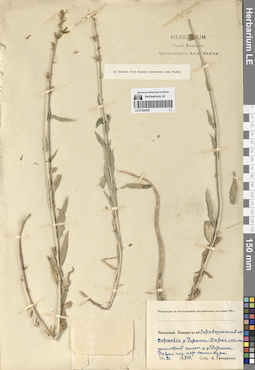
LE 01290369
Groups of specimens: Образцы сектора Средней АзииRecord creation: 2024-08-04, Daria Yudova, PhotoScan D2.Citation: Specimen LE 01290369 // Virtual herbarium of Komarov Botanical Institute RAS — http://re.herbariumle.ru/01290369
LE 01290497
Asyneuma campanuloides (M. Bieb. ex Sims) Bornm. det. Fedorov, Andrey Aleksandrovich at 1954
Collectors: Marcowicz, Vasilii Vasilevicz Collection date: 03.07.1899. Administrative regions: RU - North Ossetia. Groups of specimens: Образцы сектора Кавказа; Соглашение Минобрнауки №075-15-2021-1056Original label text:Кавказ, Осетия, Владикавказский округ, Терская область. Горные луга.
Comment: 3.VII.99
В. В. Маркович
Caucasus, Ossetia, Vladikavkaz district.
03.07.1899
Coll. V. V. Marcowicz
LE 01290368
Groups of specimens: Образцы сектора Средней АзииRecord creation: 2024-08-04, Daria Yudova, PhotoScan D2.Citation: Specimen LE 01290368 // Virtual herbarium of Komarov Botanical Institute RAS — http://re.herbariumle.ru/01290368
LE 01290496
Asyneuma campanuloides (M. Bieb. ex Sims) Bornm.
Collectors: Menitsky, Yuri Leonardovich; Popova, Tamara Nikitichna Field collecting number: 59. Collection date: 23.07.1996. Administrative regions: RU - Kabardino-Balkarskaya Respublika. Groups of specimens: Образцы сектора Кавказа; Соглашение Минобрнауки №075-15-2021-1056Original label text:Северный Кавказ, Кабардино-Балкария, окрестности села Безенги.
Coordinates (geographic position): 43° 12′ 55.44″ N, 43° 16′ 49.3″ EComment: 23.07.1996
Ю. Меницкий, Т. Попова
Northern Caucasus, Kabardino-Balkaria, vicinity of the village of Bezengi.
Record creation: 2024-08-04, Daria Yudova, PhotoScan D2.Citation: Specimen LE 01290496 // Virtual herbarium of Komarov Botanical Institute RAS — http://re.herbariumle.ru/0129049623.07.1996
Coll. Yu. Menitsky, T. Popova
LE 01290367
Groups of specimens: Образцы сектора Средней АзииRecord creation: 2024-08-04, Daria Yudova, PhotoScan D2.Citation: Specimen LE 01290367 // Virtual herbarium of Komarov Botanical Institute RAS — http://re.herbariumle.ru/01290367
LE 01290495
Asyneuma campanuloides (M. Bieb. ex Sims) Bornm. det. Konechnaya, Galina Yurievna
Collectors: Konechnaya, Galina Yurievna; Haare, Ado Oskarovich Collection date: 19.08.1990. Administrative regions: GE - Abkhazia. Groups of specimens: Образцы сектора Кавказа; Соглашение Минобрнауки №075-15-2021-1056Original label text:Абхазская АССР, Кодорское ущелье, правый борт, хр. Хутиа 4 км на С от моста в с. Генцвиши; субальп., ю. склон, 2200 м н.у.м.
Coordinates (geographic position): 43° 6′ 38.98″ N, 41° 48′ 3.4″ E 2200 m a.s.l.Comment: 19.VIII.1990
Г. Ю. Конечная, А. О. Хааре
Abkhazia, right side of the Kodori Gorge, Khutia ridge 4 km to the north from the bridge in the village Gentsvishi; subalps, south slope, 2200 m above sea level.
Record creation: 2024-08-04, Daria Yudova, PhotoScan D2.Citation: Specimen LE 01290495 // Virtual herbarium of Komarov Botanical Institute RAS — http://re.herbariumle.ru/0129049519.08.1990
Coll. G. Yu. Konechnaya, A. O. Haare
LE 01290366
Groups of specimens: Образцы сектора Средней АзииRecord creation: 2024-08-04, Daria Yudova, PhotoScan D2.Citation: Specimen LE 01290366 // Virtual herbarium of Komarov Botanical Institute RAS — http://re.herbariumle.ru/01290366
LE 01290494
Asyneuma campanuloides (M. Bieb. ex Sims) Bornm. det. Fedorov, Andrey Aleksandrovich at 1954
Collectors: Sachokia, Michail Fedorovich Collection date: 28.07.1929. Administrative regions: AZ - Azerbaijan. Expedition: Геоботаническое обследование пастбищ ССР Азербайджана по заданию Наркомзема (1929)Groups of specimens: Образцы сектора Кавказа; Соглашение Минобрнауки №075-15-2021-1056Original label text:Transcaucasia, Azerbajdzhan, prov. Baku, distr. Kuba. In pascuis alpinis prope pag. Kryz [= Грыз, Гырыз].
Coordinates (geographic position): 41° 12′ 39.41″ N, 48° 14′ 33.67″ EComment: 28.VII.1929
M. Sachokjia
Azerbajdzhan, the Gryz village.
Record creation: 2024-08-04, Daria Yudova, PhotoScan D2.Citation: Specimen LE 01290494 // Virtual herbarium of Komarov Botanical Institute RAS — http://re.herbariumle.ru/0129049428.07.1929
Coll. M. Sachokia
LE 01290365
Groups of specimens: Образцы сектора Средней АзииRecord creation: 2024-08-04, Daria Yudova, PhotoScan D2.Citation: Specimen LE 01290365 // Virtual herbarium of Komarov Botanical Institute RAS — http://re.herbariumle.ru/01290365
LE 01290493
Asyneuma campanuloides (M. Bieb. ex Sims) Bornm. det. Fedorov, Andrey Aleksandrovich at 1954
Collectors: Palibin, Ivan Vladimirovich Field collecting number: 1971. Collection date: 08.08.1912. Administrative regions: GE - Abkhazia. Groups of specimens: Образцы сектора Кавказа; Соглашение Минобрнауки №075-15-2021-1056Original label text:№ 1971
Coordinates (geographic position): 43° 27′ 49.5″ N, 40° 29′ 26.36″ EComment: Гора Пшигишха [= Пшегишхва].
Бассейн Бзыби.
8.VIII.1912
И. В. Палибин
Abkhazia. Mount Pshigishkha [= Pshegishkhva]. Basin of the Bzyb River.
Record creation: 2024-08-04, Daria Yudova, PhotoScan D2.Citation: Specimen LE 01290493 // Virtual herbarium of Komarov Botanical Institute RAS — http://re.herbariumle.ru/012904938.08.1912
Coll. I. V. Palibin
LE 01290364
Groups of specimens: Образцы сектора Средней АзииRecord creation: 2024-08-04, Daria Yudova, PhotoScan D2.Citation: Specimen LE 01290364 // Virtual herbarium of Komarov Botanical Institute RAS — http://re.herbariumle.ru/01290364
LE 01290492
Asyneuma campanuloides (M. Bieb. ex Sims) Bornm. det. Fedorov, Andrey Aleksandrovich at 1954
Collectors: Radde, Gustav Ferdinand Richard Johannes von Administrative regions: GE - Georgia. Groups of specimens: Образцы сектора Кавказа; Соглашение Минобрнауки №075-15-2021-1056Original label text:30.
Coordinates (geographic position): 42° 52′ 27.36″ N, 43° 20′ 12.28″ EComment: Rion Quellen
7000' - 9000'
22 Aug. - 3 Sept. 1864
Radde
Georgia. The Rioni river.
Record creation: 2024-08-04, Daria Yudova, PhotoScan D2.Citation: Specimen LE 01290492 // Virtual herbarium of Komarov Botanical Institute RAS — http://re.herbariumle.ru/012904927000' - 9000'
22.08 - 3.09 1864
Coll. Radde
LE 01290363
Groups of specimens: Образцы сектора Средней АзииRecord creation: 2024-08-04, Daria Yudova, PhotoScan D2.Citation: Specimen LE 01290363 // Virtual herbarium of Komarov Botanical Institute RAS — http://re.herbariumle.ru/01290363
LE 01290491
Asyneuma campanuloides (M. Bieb. ex Sims) Bornm. det. Fedorov, Andrey Aleksandrovich at 1954
Collectors: Smirnow, Mikhail Nikolaevich Collection date: 1879. Groups of specimens: Образцы сектора Кавказа; Соглашение Минобрнауки №075-15-2021-1056Original label text:In monte [...] Caucasis
Record creation: 2024-08-04, Daria Yudova, PhotoScan D2.Citation: Specimen LE 01290491 // Virtual herbarium of Komarov Botanical Institute RAS — http://re.herbariumle.ru/01290491