View
Add
Copy
Edit
Delete
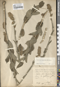
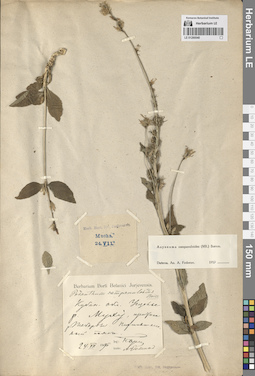
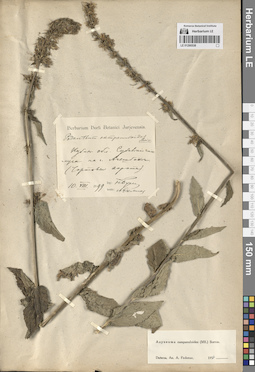
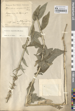
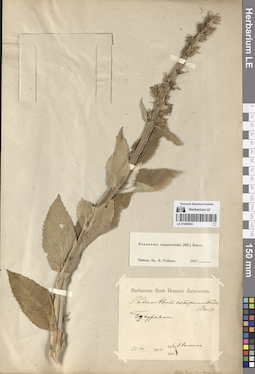
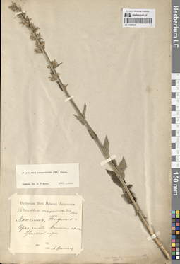
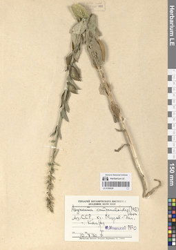
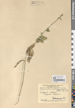
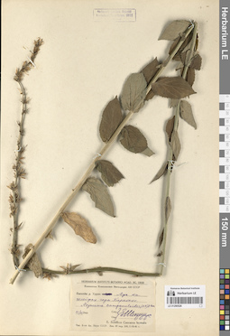
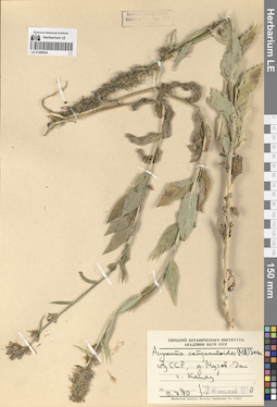
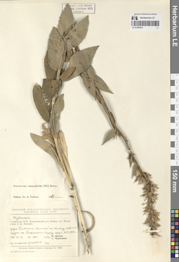
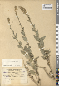
LE 01290542
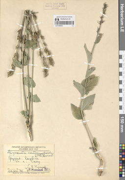
Asyneuma campanuloides (M. Bieb. ex Sims) Bornm. det. Fedorov, Andrey Aleksandrovich at 1954
Collectors: Busch, Nikolai Adolfovich (Nikolaj Adolfowitsch) Collection date: 24.07.1899. Administrative regions: RU - Respublika Adygeya. Groups of specimens: Образцы сектора Кавказа; Соглашение Минобрнауки №075-15-2021-1056Original label text:Кубанская область. Субальпийские луга в верховьях реки Белой.
Coordinates (geographic position): 43° 58′ 30.95″ N, 39° 55′ 10.68″ EComment: 24.VII.1899
Н. Буш
Respublika Adygeya.
Record creation: 2024-08-04, Daria Yudova, PhotoScan D2.Citation: Specimen LE 01290542 // Virtual herbarium of Komarov Botanical Institute RAS — http://re.herbariumle.ru/01290542Subalpine meadows in the upper reaches of the Belaya River.
24.07.1899
Coll. N. Busch
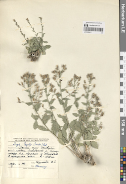
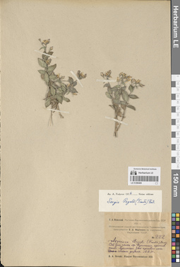
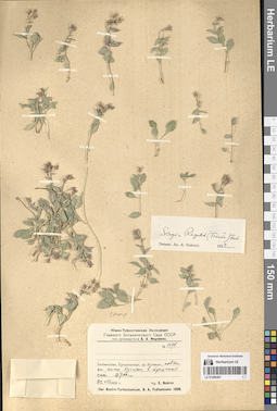
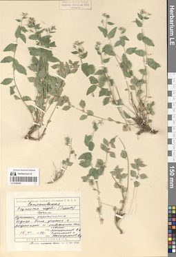
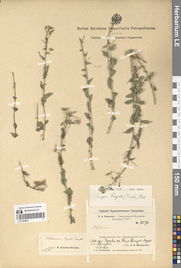
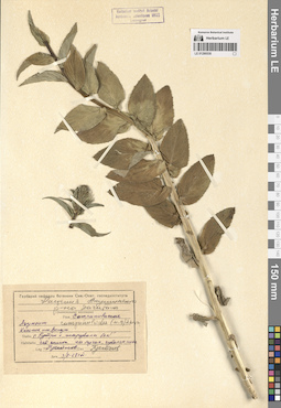
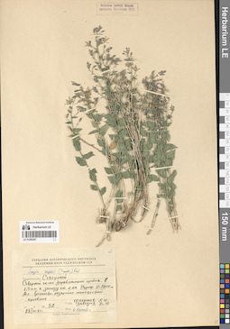
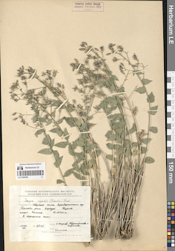
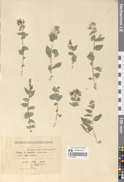
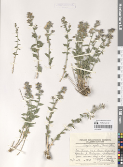
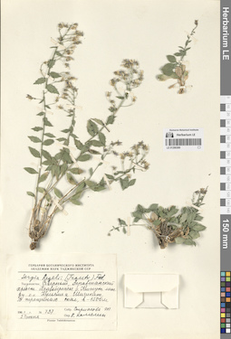
LE 01290411
Sergia regelii (Trautv.) Fed. det. Kamelin, Rudolph Vladimirovich
Collectors: Strizhova, Tamara Georgievna Field collecting number: 737. Collection date: 27.06.1961. Administrative regions: TJ - Tajikistan. Groups of specimens: Образцы сектора Средней АзииOriginal label text:Таджикистан. Северный склон Зеравшанского хребта. Правобережье реки Кисжут между кишлаками Куляли и Шишкат. В трещинах скал. H = 1500 м.
Coordinates (geographic position): 39° 22′ 36.83″ N, 68° 3′ 1.94″ EComment: № 737
27.VI.1961
Стрижова Т. Г.
Tajikistan. Northern slope of the Zeravshan ridge. The right bank of the Kiszhut River between the villages of Kulyali and Shishkat. In the cracks of the rocks. H = 1500 m.
Record creation: 2024-08-04, Daria Yudova, PhotoScan D2.Citation: Specimen LE 01290411 // Virtual herbarium of Komarov Botanical Institute RAS — http://re.herbariumle.ru/01290411№ 737
27.06.1961
Coll. T. G. Strizhova
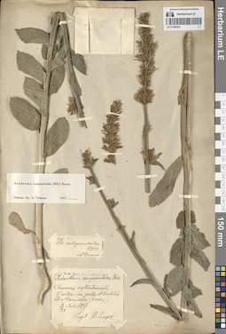
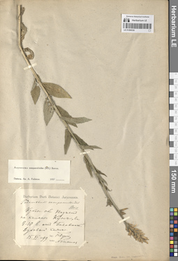
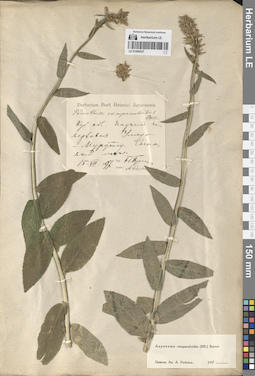
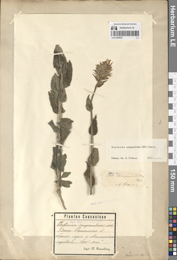
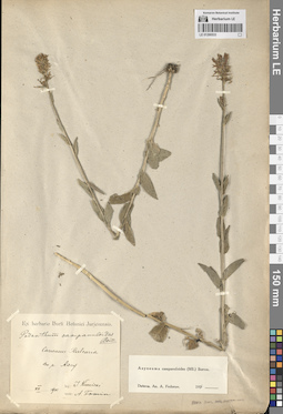
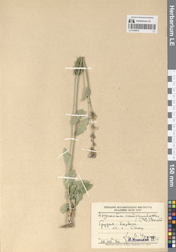
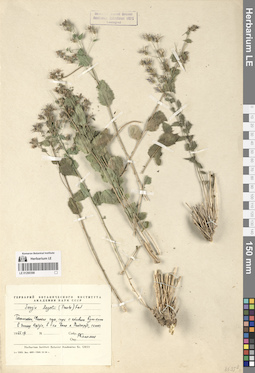
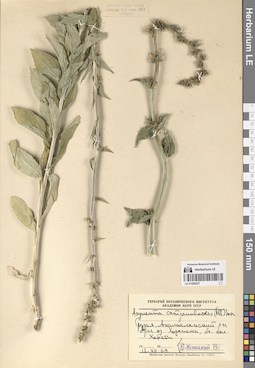
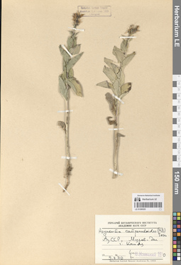
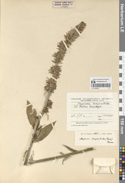
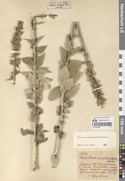
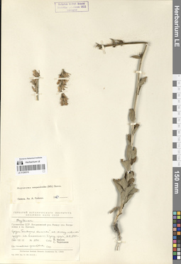
LE 01290541
Asyneuma campanuloides (M. Bieb. ex Sims) Bornm. det. Fedorov, Andrey Aleksandrovich at 1954
Collection date: 09.07.1897. Administrative regions: RU - North Ossetia. Groups of specimens: Образцы сектора Кавказа; Соглашение Минобрнауки №075-15-2021-1056Original label text:Caucasus septentrionalis.
Coordinates (geographic position): 42° 39′ 37.93″ N, 43° 50′ 26.39″ ERecord creation: 2024-08-04, Daria Yudova, PhotoScan D2.Citation: Specimen LE 01290541 // Virtual herbarium of Komarov Botanical Institute RAS — http://re.herbariumle.ru/01290541Ossetia: in pratis et herbidis ad Mamisson (8000 p.)
9-21 Juli 1897
Legit B. Zinger
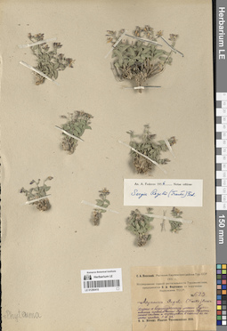
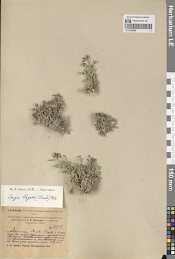
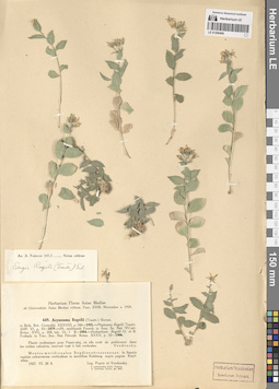
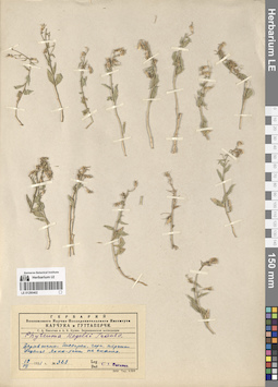
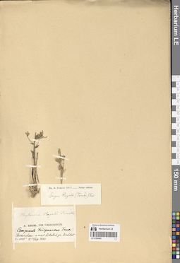
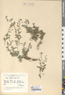
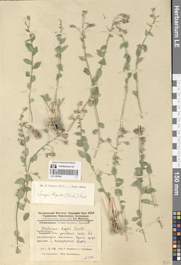
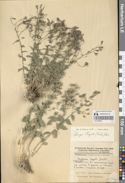
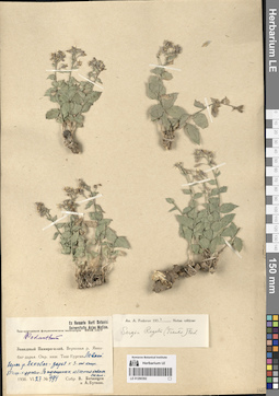
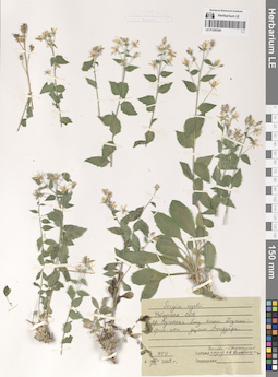
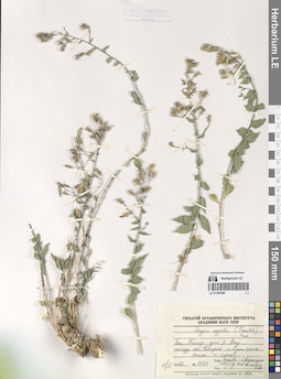
LE 01290410
Sergia regelii (Trautv.) Fed. det. Fedorov, Andrey Aleksandrovich at 1956
Collectors: Nevski, Sergei Arsenjevic Field collecting number: 623. Collection date: 05.07.1931. Original label text:С. А. Невский. Растения Карлюкского района Тур. ССР. 1931 г.
Comment: Исследование сорной растительности Туркменистана, предпринятое Б. А. Федченко по поручению Наркомзема ТССР.
№ 623
Подъем к водораздельной линии Кугитанга против кишлака Кугитанг. Каменистые склоны и трещины в скалах близ самого гребня.
5.VII.31г.
Ascent to the Kugitang watershed line opposite the Kugitang village. Rocky slopes and cracks in the rocks near the ridge.
Record creation: 2024-08-04, Daria Yudova, PhotoScan D2.Citation: Specimen LE 01290410 // Virtual herbarium of Komarov Botanical Institute RAS — http://re.herbariumle.ru/01290410№ 623
5.07.1931
Coll. S. A. Nevski
LE 01290540
Asyneuma campanuloides (M. Bieb. ex Sims) Bornm. det. Fedorov, Andrey Aleksandrovich at 1954
Collectors: Busch, Nikolai Adolfovich (Nikolaj Adolfowitsch) Collection date: 24.07.1896. Administrative regions: RU - Karachayevo-Cherkesiya. Groups of specimens: Образцы сектора Кавказа; Соглашение Минобрнауки №075-15-2021-1056Original label text:Кубанская область. Ущелье р. Муху, притока р. Теберда. Пихтово-еловый пояс.
Coordinates (geographic position): 43° 28′ 42.72″ N, 41° 38′ 19.68″ EComment: 24.VII.1896
Н. Буш
Karachayevo-Cherkesiya.
Record creation: 2024-08-04, Daria Yudova, PhotoScan D2.Citation: Specimen LE 01290540 // Virtual herbarium of Komarov Botanical Institute RAS — http://re.herbariumle.ru/01290540The gorge of the Muhu river, a tributary of the Teberda river. Fir-spruce belt.
24.07.1896
Coll. N. Busch
LE 01290409
Sergia regelii (Trautv.) Fed. det. Fedorov, Andrey Aleksandrovich at 1956
Collectors: Nevski, Sergei Arsenjevic Field collecting number: 222. Collection date: 12.06.1931. Administrative regions: TM - Turkmenistan. Groups of specimens: Образцы сектора Средней АзииOriginal label text:С. А. Невский. Растения Карлюкского района Тур. ССР. 1931 г.
Coordinates (geographic position): 37° 54′ 42.06″ N, 66° 27′ 59.51″ EComment: Исследование сорной растительности Туркменистана, предпринятое Б. А. Федченко по поручению Наркомзема ТССР.
№ 222
Северо-западный склон хребта Кугитанг против кишлака Кугитанг. Зона арчевого леса. Стены ущелья.
12.VI.31г.
The northwestern slope of the Kugitang ridge against the village of Kugitang. Gorge walls.
№ 222
5.06.1931
Coll. S. A. Nevski
LE 01290539
Asyneuma campanuloides (M. Bieb. ex Sims) Bornm. det. Fedorov, Andrey Aleksandrovich at 1954
Collectors: Busch, Nikolai Adolfovich (Nikolaj Adolfowitsch) Collection date: 15.06.1899. Administrative regions: RU - Krasnodarskiy Kray. Groups of specimens: Образцы сектора Кавказа; Соглашение Минобрнауки №075-15-2021-1056Original label text:Кубанская область. Подъем на поляны Кун, в 8-10 в. от Баговской. Дубовый пояс.
Coordinates (geographic position): 44° 5′ 51.3″ N, 40° 27′ 1.4″ EComment: 15.VI.1899
Н. Буш
Krasnodarskiy Kray. The Kun glades, 8-10 versts from the Bagovskaya village. Oak belt.
Record creation: 2024-08-04, Daria Yudova, PhotoScan D2.Citation: Specimen LE 01290539 // Virtual herbarium of Komarov Botanical Institute RAS — http://re.herbariumle.ru/0129053915.06.1899
Coll. N. Busch
LE 01290408
Sergia regelii (Trautv.) Fed. det. Fedorov, Andrey Aleksandrovich at 1956
Collectors: Nevski, Sergei Arsenjevic Field collecting number: 595. Collection date: 05.07.1931. Administrative regions: TM - Turkmenistan. Groups of specimens: Образцы сектора Средней АзииOriginal label text:С. А. Невский. Растения Карлюкского района Тур. ССР 1931 г.
Comment: Исследование сорной растительности Туркменистана, предпринятое Б. А. Федченко по поручению Наркомзема ТССР.
№ 595
Спуск от гребня Кугитанга против кишлака Маркуши. Высокогорные луга с колючими кустарниками и каменистые склоны выше зоны арчевого леса.
5.VII.31 г.
С. А. Невский
№ 595
Record creation: 2024-08-04, Daria Yudova, PhotoScan D2.Citation: Specimen LE 01290408 // Virtual herbarium of Komarov Botanical Institute RAS — http://re.herbariumle.ru/01290408Descent from the Kugitang ridge opposite the village of Markushi. High-mountain meadows with thorny bushes and rocky slopes.
5.07.1931
Coll. S. A. Nevski
LE 01290538
Asyneuma campanuloides (M. Bieb. ex Sims) Bornm. det. Fedorov, Andrey Aleksandrovich at 1954
Collectors: Busch, Nikolai Adolfovich (Nikolaj Adolfowitsch) Collection date: 10.08.1899. Administrative regions: RU - Respublika Adygeya. Groups of specimens: Образцы сектора Кавказа; Соглашение Минобрнауки №075-15-2021-1056Original label text:Кубанская область. Субальпийские луга на горе Ачешбок (Чертовы ворота).
Coordinates (geographic position): 43° 58′ 54.77″ N, 40° 27′ 44.23″ EComment: 10.VIII.1899
Н. Буш
Adygeya. Subalpine meadows on the Acheshbok Mount (Devil's Gate).
Record creation: 2024-08-04, Daria Yudova, PhotoScan D2.Citation: Specimen LE 01290538 // Virtual herbarium of Komarov Botanical Institute RAS — http://re.herbariumle.ru/0129053810.08.1899
Coll. N. Busch
LE 01290407
Sergia regelii (Trautv.) Fed. det. Fedorov, Andrey Aleksandrovich at 1954
Collectors: Bobrov, Evgeniy Grigorievich Field collecting number: 1471. Collection date: 23.08.1928. Administrative regions: TM - Turkmenistan. Groups of specimens: Образцы сектора Средней АзииOriginal label text:№ 1471
Coordinates (geographic position): 37° 54′ 42.71″ N, 66° 29′ 35.5″ E 2700 m a.s.l.Comment: Turkmenistan, Туркменистан, хребет Кугитанг, подъем от кишлака Кугитанг, в трещинах скал. 2700 м.
23.VIII.1928
Leg. E. Bobrov
№ 1471
Record creation: 2024-08-04, Daria Yudova, PhotoScan D2.Citation: Specimen LE 01290407 // Virtual herbarium of Komarov Botanical Institute RAS — http://re.herbariumle.ru/01290407Turkmenistan, Kugitang ridge, rise from the Kugitang village, in the cracks of the rocks. 2700 m.
23.08.1928
Coll. E. Bobrov
LE 01290537
Asyneuma campanuloides (M. Bieb. ex Sims) Bornm. det. Fedorov, Andrey Aleksandrovich at 1954
Collectors: Busch, Nikolai Adolfovich (Nikolaj Adolfowitsch) Collection date: 15.07.1897. Administrative regions: RU - Karachayevo-Cherkesiya - Karachayevskiy Rayon. Groups of specimens: Образцы сектора Кавказа; Соглашение Минобрнауки №075-15-2021-1056Original label text:Кубанская область. Подъем в верховья Уллу-Мурутчу [= Уллу-Муруджу]. Сосновый лес.
Coordinates (geographic position): 43° 19′ 38.64″ N, 41° 47′ 34.46″ EComment: 15.VII.1897
Н. Буш
Karachayevo-Cherkesiya, the upper reaches of Ullu-Murutchu [= Ullu-Muruju]. Pine forest.
Record creation: 2024-08-04, Daria Yudova, PhotoScan D2.Citation: Specimen LE 01290537 // Virtual herbarium of Komarov Botanical Institute RAS — http://re.herbariumle.ru/0129053715.07.1897
Coll. N. Busch
LE 01290406
Sergia regelii (Trautv.) Fed. det. Fedorov, Andrey Aleksandrovich at 1954
Collectors: Popov; Vvedensky, Aleksei Ivanovich Collection date: 28.06.1927. Administrative regions: UZ - Uzbekistan. Groups of specimens: Образцы сектора Средней АзииOriginal label text:Montes meridionales: Sogdiano-transoxanae. In fissuris rupium calcarearum verticalium in montibus Kuhitang supra pagum Kizyl-alma.
Coordinates (geographic position): 37° 51′ 34.49″ N, 66° 40′ 53.61″ ERecord creation: 2024-08-04, Daria Yudova, PhotoScan D2.Citation: Specimen LE 01290406 // Virtual herbarium of Komarov Botanical Institute RAS — http://re.herbariumle.ru/0129040628.VI.1927
Leg. Popov et Vvedensky
LE 01290536
Asyneuma campanuloides (M. Bieb. ex Sims) Bornm. det. Fedorov, Andrey Aleksandrovich at 1954
Collectors: Kusnetzov N. Collection date: 03.07.1900. Administrative regions: AM - Armenia. Groups of specimens: Образцы сектора Кавказа; Соглашение Минобрнауки №075-15-2021-1056Original label text:Караклис, станция Карсской железной дороги. Лес.
Coordinates (geographic position): 40° 49′ 1.26″ N, 44° 29′ 14.41″ EComment: 3.VII.1900
Н. Кузнецов
Armenia, Karaklis [= Vanadzor]. Railway station.
Record creation: 2024-08-04, Daria Yudova, PhotoScan D2.Citation: Specimen LE 01290536 // Virtual herbarium of Komarov Botanical Institute RAS — http://re.herbariumle.ru/012905363.07.1900
Coll. N. Kusnetztov
LE 01290405
Sergia regelii (Trautv.) Fed.
Collection date: 16.06.1966. Administrative regions: TM - Turkmenistan. Groups of specimens: Образцы сектора Средней АзииOriginal label text:Кугитанг, окрестности Ходжа-Пиль, ущелье с родником и отвесными скалами.
Coordinates (geographic position): 37° 56′ 30.09″ N, 66° 35′ 58.26″ EComment: 16.VI.1966
Мещеряков А. А., [...]
Kugitang, vicinity of Khoja-Pil [Khojapil], gorge with a spring and steep cliffs.
16.06.1966
Coll. A.A. Mesczerjakov, [...]
LE 01290535
Asyneuma campanuloides (M. Bieb. ex Sims) Bornm. det. Fedorov, Andrey Aleksandrovich at 1954
Collectors: Desoulavy, Numa Avgustovich Subregion: South Ossetia, Dzau district. Groups of specimens: Образцы сектора Кавказа; Соглашение Минобрнауки №075-15-2021-1056Original label text:Военно-Осетинская дорога. Горные луга у Мамиссонского перевала. 7000' - 8000'.
N. DesoulavySouth Ossetia, Dzau district, the Mamison pass.
Record creation: 2024-08-04, Daria Yudova, PhotoScan D2.Citation: Specimen LE 01290535 // Virtual herbarium of Komarov Botanical Institute RAS — http://re.herbariumle.ru/01290535Coll. N. Desoulavy
LE 01290404
Sergia regelii (Trautv.) Fed. det. Fedorov, Andrey Aleksandrovich at 1954
Collectors: Preobrazhensky, I. A. Collection date: 17.06.1912. Administrative regions: TJ - Tajikistan. Groups of specimens: Образцы сектора Средней АзииOriginal label text:И. А. Преображенский 1912 г.
Coordinates (geographic position): 39° 16′ 47.2″ N, 67° 30′ 40.67″ EComment: Самаркандская область. От перевала к Фарабу, 17.VI.
Tajikistan. From the pass to Farab [Farob].
Record creation: 2024-08-04, Daria Yudova, PhotoScan D2.Citation: Specimen LE 01290404 // Virtual herbarium of Komarov Botanical Institute RAS — http://re.herbariumle.ru/0129040417.06.1912
Coll. I. A. Preobrazhensky
LE 01290534
Asyneuma campanuloides (M. Bieb. ex Sims) Bornm. det. Fedorov, Andrey Aleksandrovich at 1954
Collectors: Fomin, Alexander Vasilyevich Collection date: 25.07.1900. Administrative regions: GE - Georgia. Groups of specimens: Образцы сектора Кавказа; Соглашение Минобрнауки №075-15-2021-1056Original label text:Бакурьяни.
Coordinates (geographic position): 41° 45′ 37.87″ N, 43° 31′ 30.53″ EComment: 25.07.1900
А. Фомин
Georgia, Bakuriani.
Record creation: 2024-08-04, Daria Yudova, PhotoScan D2.Citation: Specimen LE 01290534 // Virtual herbarium of Komarov Botanical Institute RAS — http://re.herbariumle.ru/0129053425.07.1900
Coll. A. Fomin
LE 01290403
Sergia regelii (Trautv.) Fed. det. Fedorov, Andrey Aleksandrovich at 1954
Collectors: Michelson, Alexander Ivanovich Field collecting number: 2572. Collection date: 17.06.1913. Administrative regions: TJ - Tajikistan. Expedition: Самаркандско-Бухарская экспедиция (1913)Groups of specimens: Образцы сектора Средней АзииOriginal label text:Северные склоны Зеравшанского хребта. Ущелье реки Артуч-дарья у кишлака Артуч.
Coordinates (geographic position): 39° 18′ 8.67″ N, 68° 8′ 30.53″ EComment: 17.VI.1913
А. И. Михельсон
Northern slopes of the Zeravshan ridge. The gorge of the Artuch-Darya river near the village of Artuch.
Record creation: 2024-08-04, Daria Yudova, PhotoScan D2.Citation: Specimen LE 01290403 // Virtual herbarium of Komarov Botanical Institute RAS — http://re.herbariumle.ru/0129040317.06.1913
Coll. A. I. Michelson
LE 01290533
Asyneuma campanuloides (M. Bieb. ex Sims) Bornm. det. Fedorov, Andrey Aleksandrovich at 1954
Collection date: 07.1901. Administrative regions: RU - Kabardino-Balkarskaya Respublika. Groups of specimens: Образцы сектора Кавказа; Соглашение Минобрнауки №075-15-2021-1056Original label text:Caucasus. Balcaria. По реке Ахсу.
Coordinates (geographic position): 42° 57′ 47.95″ N, 43° 23′ 28.67″ EComment: VII.1901
[...]
Kabardino-Balkarskaya Respublika, the Akhsu river.
Record creation: 2024-08-04, Daria Yudova, PhotoScan D2.Citation: Specimen LE 01290533 // Virtual herbarium of Komarov Botanical Institute RAS — http://re.herbariumle.ru/0129053307.1901
[...]
LE 01290402
Sergia regelii (Trautv.) Fed.
Collectors: Nikitin, S. A. Field collecting number: 323. Collection date: 19.07.1931. Administrative regions: TJ - Viloyati Sughd. Expedition: С. А. Никитин и А. К. Кулик. Зеравшанская экспедиция ()Groups of specimens: Образцы сектора Средней АзииOriginal label text:Зеравшано-Гиссарская горная страна. Ущелье Якка-Хана на скалах.
Coordinates (geographic position): 39° 19′ 7.43″ N, 68° 9′ 17.86″ EComment: № 323
19.VII.1931
С. А. Никитин
Zeravshan-Gissar mountainous country. Yakka-Hana gorge on the rocks.
Record creation: 2024-08-04, Daria Yudova, PhotoScan D2.Citation: Specimen LE 01290402 // Virtual herbarium of Komarov Botanical Institute RAS — http://re.herbariumle.ru/01290402№ 323
19.07.1931
Coll. S. A. Nikitin
LE 01290532
Asyneuma campanuloides (M. Bieb. ex Sims) Bornm. det. Fedorov, Andrey Aleksandrovich at 1954
Administrative regions: GE - Georgia. Groups of specimens: Образцы сектора Кавказа; Соглашение Минобрнауки №075-15-2021-1056Original label text:манглис, Тифлисская губерния.
Coordinates (geographic position): 41° 40′ 40.97″ N, 44° 15′ 6.81″ EComment: Верхняя часть восточного склона Желтой горы.
Georgia, Manglisi, the upper part of the eastern slope of the Zhyeltaya mount.
Record creation: 2024-08-04, Daria Yudova, PhotoScan D2.Citation: Specimen LE 01290532 // Virtual herbarium of Komarov Botanical Institute RAS — http://re.herbariumle.ru/01290532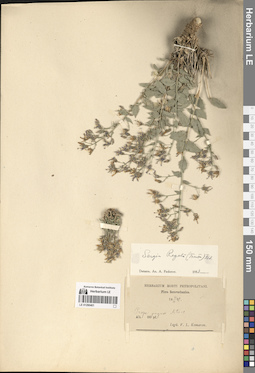
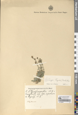
LE 01290401
Sergia regelii (Trautv.) Fed. det. Fedorov, Andrey Aleksandrovich at 1954
Collectors: Komarov, Vladimir Leontjevich Collection date: 14.06.1892. Administrative regions: TJ - Tajikistan. Groups of specimens: Образцы сектора Средней АзииOriginal label text:Prope pagum Artucz.
Coordinates (geographic position): 39° 20′ 10.56″ N, 68° 6′ 56.52″ ERecord creation: 2024-08-04, Daria Yudova, PhotoScan D2.Citation: Specimen LE 01290401 // Virtual herbarium of Komarov Botanical Institute RAS — http://re.herbariumle.ru/0129040114.VI.1892
V. L. Komarov
LE 01290531
Asyneuma campanuloides (M. Bieb. ex Sims) Bornm. det. Menitsky, Yuri Leonardovich
Collection date: 25.08.1970. Administrative regions: GE - Georgia. Groups of specimens: Образцы сектора Кавказа; Соглашение Минобрнауки №075-15-2021-1056Original label text:Грузия: Казбеги. Близ села Сноу [= Сно].
Coordinates (geographic position): 42° 36′ 43.76″ N, 44° 38′ 33.59″ EComment: 25.VIII.70
В. Чунов
Georgia: Kazbegi. The Sno village.
Record creation: 2024-08-04, Daria Yudova, PhotoScan D2.Citation: Specimen LE 01290531 // Virtual herbarium of Komarov Botanical Institute RAS — http://re.herbariumle.ru/0129053125.08.1970
Coll. V. Chunov
LE 01290400
Sergia regelii (Trautv.) Fed. det. Fedorov, Andrey Aleksandrovich at 1954
Collectors: Regel, (Johann) Albert von Collection date: 31.08.1884. Administrative regions: TJ - Tajikistan. Groups of specimens: Образцы сектора Средней АзииOriginal label text:Sarawschan: in mont. Artutsch pr. Kschtut.
Coordinates (geographic position): 39° 20′ 10.56″ N, 68° 6′ 56.52″ ERecord creation: 2024-08-04, Daria Yudova, PhotoScan D2.Citation: Specimen LE 01290400 // Virtual herbarium of Komarov Botanical Institute RAS — http://re.herbariumle.ru/012904005 - 6000'
14 - 31.VIII.1884
LE 01290530
Asyneuma campanuloides (M. Bieb. ex Sims) Bornm. det. Husseinov, Sch. A.
Collectors: Husseinov, Sch. A. Collection date: 03.07.1968. Administrative regions: RU - Dagestan - Akushinskiy Rayon. Groups of specimens: Образцы сектора Кавказа; Соглашение Минобрнауки №075-15-2021-1056Original label text:Село Бутри + ["шарубала бек"]
Coordinates (geographic position): 42° 10′ 55.16″ N, 47° 25′ 55.39″ EComment: Северный склон, на лугах, субальпийский пояс.
3.7.68 год
Leg. Гусейнов
Dagestan, Akushinskiy district, the Butri village. Northern slope, in meadows, subalpine zone.
Record creation: 2024-08-04, Daria Yudova, PhotoScan D2.Citation: Specimen LE 01290530 // Virtual herbarium of Komarov Botanical Institute RAS — http://re.herbariumle.ru/012905303.07.1968
Coll. Husseinov
LE 01290399
Sergia regelii (Trautv.) Fed.
Collectors: Kamelin, Rudolph Vladimirovich Collection date: 07.1965. Administrative regions: TJ - Tajikistan. Groups of specimens: Образцы сектора Средней АзииOriginal label text:Таджикистан, Фанские горы, окрестности озера Кули-Калон, скалы выше озера, 2700 и выше.
Coordinates (geographic position): 39° 14′ 55.24″ N, 68° 10′ 3.15″ E 2700 m a.s.l.Comment: 1965-VII
Р. Камелин
Tajikistan, Fan Mountains, surroundings of Lake Kuli-Kalon, rocks above the lake, 2700 m and above.
Record creation: 2024-08-04, Daria Yudova, PhotoScan D2.Citation: Specimen LE 01290399 // Virtual herbarium of Komarov Botanical Institute RAS — http://re.herbariumle.ru/0129039907.1965
R. Kamelin
LE 01290529
Asyneuma campanuloides (M. Bieb. ex Sims) Bornm. det. Menitsky, Yuri Leonardovich at 1970
Collectors: Menitsky, Yuri Leonardovich Collection date: 10.07.1970. Administrative regions: AZ - Azerbaijan. Groups of specimens: Образцы сектора Кавказа; Соглашение Минобрнауки №075-15-2021-1056Original label text:АзССР, хребет Муров-даг, гора Капяз [= Кяпаз, Кяпас].
Coordinates (geographic position): 40° 18′ 13.86″ N, 46° 15′ 43.54″ EComment: 10.7.70
Ю. Меницкий
Azerbaijan, the Murovdağ ridge, the Mount Kapaz.
Record creation: 2024-08-04, Daria Yudova, PhotoScan D2.Citation: Specimen LE 01290529 // Virtual herbarium of Komarov Botanical Institute RAS — http://re.herbariumle.ru/0129052910.07.1970
Coll. Yu. Menitsky
LE 01290398
Sergia regelii (Trautv.) Fed.
Collectors: Kamelin, Rudolph Vladimirovich Collection date: 07.1965. Administrative regions: TJ - Tajikistan. Groups of specimens: Образцы сектора Средней АзииOriginal label text:Таджикистан, Фанские горы, спуск с котловины Кули-калон в долину Кштута, в 5 км выше к. Панджруд, скалы.
Coordinates (geographic position): 39° 22′ 34.91″ N, 68° 3′ 48.27″ EComment: 1965-VII
Р. Камелин
Tajikistan, Fan Mountains, descent from the Kuli-Kalon basin into the Kshtut valley, 5 km above the village of Panjrud, rocks.
07.1965
Coll. R. Kamelin
LE 01290528
Asyneuma campanuloides (M. Bieb. ex Sims) Bornm. det. Menitsky, Yuri Leonardovich at 1971
Collectors: Menitsky, Yuri Leonardovich Collection date: 08.1971. Administrative regions: GE - Georgia. Groups of specimens: Образцы сектора Кавказа; Соглашение Минобрнауки №075-15-2021-1056Original label text:Главный Кавказ. Грузия: Казбеги.
Coordinates (geographic position): 42° 41′ 53.85″ N, 44° 30′ 52.29″ EComment: VIII.71
Ю. Меницкий
Main Caucasus. Georgia: Kazbegi.
08.1971Coll. Yu. Menitsky
LE 01290397
Sergia regelii (Trautv.) Fed. det. Kamelin, Rudolph Vladimirovich
Collectors: Filatov, E. I.; Zavedeev, V. N. Field collecting number: 92. Collection date: 28.06.1961. Administrative regions: TJ - Tajikistan. Groups of specimens: Образцы сектора Средней АзииOriginal label text:Таджикистан. Северный склон Зеравшанского хребта, 1,5 км к западу от кишлака Чориф, h = 2300 м. Асс. Гречихово-розарийно-типчаковый арчовник.
Coordinates (geographic position): 39° 31′ 43.11″ N, 67° 49′ 42.49″ E 2300 m a.s.l.Comment: № 92
28.VI.1961 г.
Филатов Е. И., Заведеев В. Н.
Tajikistan. Northern slope of the Zeravshan ridge, 1.5 km west of the village of Chorif, h = 2300 m.
Record creation: 2024-08-04, Daria Yudova, PhotoScan D2.Citation: Specimen LE 01290397 // Virtual herbarium of Komarov Botanical Institute RAS — http://re.herbariumle.ru/01290397№ 92
28.06.1961
Coll. E. I. Filatov, V. N. Zavedeev
LE 01290527
Asyneuma campanuloides (M. Bieb. ex Sims) Bornm. det. Menitsky, Yuri Leonardovich at 1970
Collectors: Menitsky, Yuri Leonardovich Collection date: 13.07.1969. Administrative regions: GE - Georgia. Groups of specimens: Образцы сектора Кавказа; Соглашение Минобрнауки №075-15-2021-1056Original label text:Грузия, Ахалкалакский район, берег озера Хозапини, близ села Ховети.
Coordinates (geographic position): 41° 15′ 32.87″ N, 43° 14′ 4.79″ EComment: 13.VII.1969
Ю. Меницкий
Georgia, Akhalkalaki region, shore of Lake Khozapini, near the village of Khoveti.
13.07.1969Coll. Yu. Menitsky
LE 01290396
Sergia regelii (Trautv.) Fed. det. Fedorov, Andrey Aleksandrovich at 1954
Collectors: Ovczinnikov, Pavel Nikolaevich; Slobodov, A.A. Field collecting number: 1100. Collection date: 16.07.1932. Administrative regions: TJ - Tajikistan. Expedition: Таджикская Комплексная Экспедиция. Геоботаническая группа проф, Б.А. Федченко (1932)Groups of specimens: Образцы сектора Средней АзииOriginal label text:Зеравшанский хребет, западная часть. По каменистым склонам вдоль озера Нежгон [Нежегон] (Маргузарские [Маргузорские] озера).
Coordinates (geographic position): 39° 13′ 20.41″ N, 67° 47′ 55.12″ EComment: 16.VII.1932
П. Овчинников и А. Слободов
Zeravshan ridge, western part. Along the rocky slopes along Lake Nezhgon [Nezhegon] (Marguzar [Marguzor] lakes).
Record creation: 2024-08-04, Daria Yudova, PhotoScan D2.Citation: Specimen LE 01290396 // Virtual herbarium of Komarov Botanical Institute RAS — http://re.herbariumle.ru/0129039616.07.1932
Coll. P. Ovczinnikov, A. Slobodov
LE 01290526
Asyneuma campanuloides (M. Bieb. ex Sims) Bornm.
Collectors: Shiffers, Evgenia Vladimirovna Collection date: 23.07.1945. Administrative regions: RU - Karachayevo-Cherkesiya. Expedition: Кавказская комплексная экспедиция АН СССР (1945 -1946)Groups of specimens: Образцы сектора Кавказа; Соглашение Минобрнауки №075-15-2021-1056; E. Schiffers. Caucasus borealis.Original label text:Бассейн р. Урупа. Луг на шлейфах горы Баранахи.
Coordinates (geographic position): 43° 58′ 17.86″ N, 41° 17′ 8.64″ EComment: 23.VII.1945
Е. Шифферс
Karachayevo-Cherkesiya, basin of the Urup river. Meadow on the Baranakha mount.
23.07.1945Coll. E. Shiffers
LE 01290395
Sergia regelii (Trautv.) Fed.
Field collecting number: 6745. Collection date: 05.08.1963. Administrative regions: TJ - Tajikistan. Groups of specimens: Образцы сектора Средней АзииOriginal label text:Таджикистан. Северный склон Зеравшанского хребта. Бассейн реки Кштут. Ущелье кишлака Негнот. В трещинах скал. H = 2400 м.
Coordinates (geographic position): 39° 21′ 28.68″ N, 68° 1′ 7.7″ EComment: № 6745
5.VIII.1963
C. Юнусов, Абдусалямова и Каримова
Tajikistan. Northern slope of the Zeravshan ridge. Basin of the Kshtut River. Gorge of Negnot village. In the cracks of the rocks. H = 2400 m.
Record creation: 2024-08-04, Daria Yudova, PhotoScan D2.Citation: Specimen LE 01290395 // Virtual herbarium of Komarov Botanical Institute RAS — http://re.herbariumle.ru/01290395№ 6745
5.08.1963
Coll. S. Junussov, Abdusalyamova and Karimova
LE 01290525
Asyneuma campanuloides (M. Bieb. ex Sims) Bornm.
Collectors: Menitsky, Yuri Leonardovich Collection date: 09.07.1970. Administrative regions: AZ - Azerbaijan. Groups of specimens: Образцы сектора Кавказа; Соглашение Минобрнауки №075-15-2021-1056Original label text:АзССР, хребет Муров-даг, гора Капяз [= Кяпаз, Кяпас].
Coordinates (geographic position): 40° 18′ 13.86″ N, 46° 15′ 43.54″ EComment: 9.7.70
Ю. Меницкий
Azerbaijan, the Murovdağ ridge, the Mount Kapaz.
Record creation: 2024-08-04, Daria Yudova, PhotoScan D2.Citation: Specimen LE 01290525 // Virtual herbarium of Komarov Botanical Institute RAS — http://re.herbariumle.ru/012905259.07.1970
Coll. Yu. Menitsky
LE 01290394
Sergia regelii (Trautv.) Fed. det. Fedorov, Andrey Aleksandrovich at 1954
Collectors: Ovczinnikov, Pavel Nikolaevich; Slobodov, A.A. Collection date: 14.06.1932. Administrative regions: TJ - Tajikistan. Expedition: Таджикская Комплексная Экспедиция. Геоботаническая группа проф, Б.А. Федченко (1932)Groups of specimens: Образцы сектора Средней АзииOriginal label text:Зеравшанский хребет. По каменистому крутому склону в ущелье реки Кштут в районе кишлака Кштут.
Coordinates (geographic position): 39° 21′ 23.66″ N, 68° 2′ 51.35″ EComment: 14.VI.1932
П. Овчинников и А. Слободов
Zeravshan ridge. Along a rocky steep slope in the gorge of the Kshtut River in the area of the village of Kshtut.
Record creation: 2024-08-04, Daria Yudova, PhotoScan D2.Citation: Specimen LE 01290394 // Virtual herbarium of Komarov Botanical Institute RAS — http://re.herbariumle.ru/0129039414.06.1932
Coll. P. Ovczinnikov, A. Slobodov
LE 01290524
Asyneuma campanuloides (M. Bieb. ex Sims) Bornm. det. Menitsky, Yuri Leonardovich at 1970
Collectors: Menitsky, Yuri Leonardovich Collection date: 09.07.1970. Administrative regions: AZ - Azerbaijan. Groups of specimens: Образцы сектора Кавказа; Соглашение Минобрнауки №075-15-2021-1056Original label text:АзССР, хребет Муров-даг, гора Капяз [= Кяпаз, Кяпас].
Coordinates (geographic position): 40° 18′ 13.86″ N, 46° 15′ 43.54″ EComment: 9.7.70
Ю. Меницкий
Azerbaijan, the Murovdağ ridge, the Mount Kapaz.
Record creation: 2024-08-04, Daria Yudova, PhotoScan D2.Citation: Specimen LE 01290524 // Virtual herbarium of Komarov Botanical Institute RAS — http://re.herbariumle.ru/012905249.07.1970
Coll. Yu. Menitsky
LE 01290393
Sergia regelii (Trautv.) Fed.
Collectors: Kudrjaschev, Serafim Nikovajevich Field collecting number: 285. Collection date: 03.08.1940. Administrative regions: UZ - Uzbekistan. Groups of specimens: Образцы сектора Средней АзииOriginal label text:Байсунская экспедиция
Coordinates (geographic position): 38° 16′ 2.52″ N, 67° 12′ 11.66″ EComment: Скалы в верхней части сая близ кишлака Аулат.
№ 285
3.VIII.1940
Кудряшев
Baysun expedition
Record creation: 2024-08-04, Daria Yudova, PhotoScan D2.Citation: Specimen LE 01290393 // Virtual herbarium of Komarov Botanical Institute RAS — http://re.herbariumle.ru/01290393Rocks in the upper part of the sai near the village of Aulat.
№ 285
3.08.1940
Сoll. Kudrjaschev
LE 01290523
Asyneuma campanuloides (M. Bieb. ex Sims) Bornm. det. Fedorov, Andrey Aleksandrovich at 1965
Collectors: Shiffers, Evgenia Vladimirovna Collection date: 04.07.1937. Administrative regions: RU - Stavropol'skiy Kray. Groups of specimens: Образцы сектора Кавказа; Соглашение Минобрнауки №075-15-2021-1056Original label text:Северный Кавказ. Кисловодск.
Coordinates (geographic position): 43° 54′ 28.7″ N, 42° 44′ 50.42″ EComment: 4.VII.1937
Е. Шифферс
North Caucasus. Stavropol'skiy Krayю Kislovodsk.
Record creation: 2024-08-04, Daria Yudova, PhotoScan D2.Citation: Specimen LE 01290523 // Virtual herbarium of Komarov Botanical Institute RAS — http://re.herbariumle.ru/012905234.07.1937
Coll. E. Shiffers
LE 01290392
Sergia regelii (Trautv.) Fed. det. Fedorov, Andrey Aleksandrovich at 1954
Collectors: Botschantzev, Victor Petrovič; Butkov, Aleksandr Yakovlevich Field collecting number: 494. Collection date: 27.06.1936. Administrative regions: UZ - Uzbekistan. Groups of specimens: Образцы сектора Средней АзииOriginal label text:Западный Памиро-алай. Верховья реки Яккабаг-дарья. Окрестности кишлака Таш-Курган. Левый берег реки Яккобаг-дарья к З от кишлака Таш-Курган. В трещинах известняковых скал.
Coordinates (geographic position): 38° 56′ 1.29″ N, 66° 52′ 48.58″ EComment: № 494
27.VI.1936
В. Бочанцев и А. Бутков
Western Pamir-Alai. The upper reaches of the Yakkabag-Darya river. The outskirts of the village of Tash-Kurgan. The left bank of the Yakkobag-Darya river to the west from the village of Tash-Kurgan. In the cracks of limestone rocks.
Record creation: 2024-08-04, Daria Yudova, PhotoScan D2.Citation: Specimen LE 01290392 // Virtual herbarium of Komarov Botanical Institute RAS — http://re.herbariumle.ru/01290392№ 494
27.06.1936
Coll. V. Botschantzev, A. Butkov
LE 01290522
Asyneuma campanuloides (M. Bieb. ex Sims) Bornm. det. Menitsky, Yuri Leonardovich at 1970
Collection date: 24.08.1970. Administrative regions: GE - Georgia. Groups of specimens: Образцы сектора Кавказа; Соглашение Минобрнауки №075-15-2021-1056Original label text:Грузия: Казбеги. Близ села Сноу [= Сно].
Coordinates (geographic position): 42° 36′ 43.76″ N, 44° 38′ 33.59″ EComment: 25.VIII.70
В. Чунов
Georgia: Kazbegi. The Sno village.
Record creation: 2024-08-04, Daria Yudova, PhotoScan D2.Citation: Specimen LE 01290522 // Virtual herbarium of Komarov Botanical Institute RAS — http://re.herbariumle.ru/0129052225.08.1970
Coll. V. Chunov
LE 01290391
Sergia regelii (Trautv.) Fed.
Collectors: Kamelin, Rudolph Vladimirovich Field collecting number: 1242. Collection date: 13.06.1982. Groups of specimens: Образцы сектора Средней АзииOriginal label text:Западный Гиссар, бассейн реки Кашка-Дарья-Аксу, верховья реки Гиляндара [Гиляндарья], правобережье, сухие склоны южной и восточной экспозиции.
Comment: № 1242
13.VI.1982
Закавк.-Среднеазиат. отряд
Р. В. Камелин и др.
Western Gissar, basin of the Kashka-Darya-Aksu river, upper reaches of the Gilandara [Gilandarya] river, right bank, dry slopes of southern and eastern exposure.
Record creation: 2024-08-04, Daria Yudova, PhotoScan D2.Citation: Specimen LE 01290391 // Virtual herbarium of Komarov Botanical Institute RAS — http://re.herbariumle.ru/01290391№ 1242
13.06.1982
Coll. R. V. Kamelin
LE 01290520
Asyneuma campanuloides (M. Bieb. ex Sims) Bornm. det. Fedorov, Andrey Aleksandrovich at 1963
Collectors: Kutscherovskaya, Sofia Evgenevna Field collecting number: 240. Collection date: 09.08.1936. Administrative regions: GE - Georgia. Groups of specimens: Образцы сектора Кавказа; Соглашение Минобрнауки №075-15-2021-1056Original label text:Грузинская ССР. Джавахетия, к северу от Тамбовки, между Кызыл-Килиссе [= Кизыл-Килиса] и Забитокдж [= Забат-агджа]
Coordinates (geographic position): 41° 38′ 47.9″ N, 43° 48′ 43.08″ EComment: Субальпийские луга.
9.VIII.36 г.
С. Кучеровская
Georgia. Javakheti, north of Tambovka, between Kyzyl-Kilisse [= Kizil-Kilissa] and Zabat-agja. Subalpine meadows.
Record creation: 2024-08-04, Daria Yudova, PhotoScan D2.Citation: Specimen LE 01290520 // Virtual herbarium of Komarov Botanical Institute RAS — http://re.herbariumle.ru/012905209.08.1936
Coll. S. Kutscherovskaya
LE 01290390
Sergia regelii (Trautv.) Fed.
Collectors: Kamelin, Rudolph Vladimirovich Field collecting number: 759. Collection date: 04.06.1982. Administrative regions: TM - Turkmenistan. Groups of specimens: Образцы сектора Средней АзииOriginal label text:Узбекская ССР, хребет Кугитанг близ кишлака Ходжай-филь-ата, ущелье Эмердара.
Coordinates (geographic position): 37° 56′ 57.44″ N, 66° 38′ 49.75″ EComment: № 759
4.VI.1982
Р. В. Камелин и др.
Uzbek SSR, Kugitang ridge near the village of Khojay-fil-ata, Emerdara gorge.
Record creation: 2024-08-04, Daria Yudova, PhotoScan D2.Citation: Specimen LE 01290390 // Virtual herbarium of Komarov Botanical Institute RAS — http://re.herbariumle.ru/01290390№ 759
4.06.1982
Coll. R.V. Kamelin et al.
LE 01290519
Asyneuma campanuloides (M. Bieb. ex Sims) Bornm. det. Fedorov, Andrey Aleksandrovich at 1963
Collectors: Tzvelev, Nikolai Nikolaievich; Czerepanov, Sergei Kirillovich Collection date: 12.07.1960. Administrative regions: GE - Georgia. Groups of specimens: Образцы сектора Кавказа; Соглашение Минобрнауки №075-15-2021-1056Original label text:Грузинская ССР. Богдановский район. Между селом Богдановка и озером Ханчали. Среди больших камней по склону невысокой гряды на восточном берегу озера, h = 1750 м.
Coordinates (geographic position): 41° 16′ 2.69″ N, 43° 34′ 40.11″ E 1750 m a.s.l.Comment: № 930
12.VII.1960
Н. Цвелев, С. Черепанов
Цветки синевато-фиолетовые
Georgia. Between the village of Bogdanovka and Lake Khanchali. Among large stones on the slope of a low ridge on the eastern shore of the lake, h = 1750 m.
Record creation: 2024-08-04, Daria Yudova, PhotoScan D2.Citation: Specimen LE 01290519 // Virtual herbarium of Komarov Botanical Institute RAS — http://re.herbariumle.ru/0129051912.07.1960
Coll. N. Tzvelev, S. Czerepanov
LE 01290389
Sergia regelii (Trautv.) Fed. det. Kamelin, Rudolph Vladimirovich
Collectors: Strizhova, Tamara Georgievna Field collecting number: 737. Collection date: 27.06.1961. Administrative regions: TJ - Tajikistan. Groups of specimens: Образцы сектора Средней АзииOriginal label text:Таджикистан Северный, Зеравшанский хребет. Правобережье реки Кштут между кишлаками Кульяли и Шишкат. В трещинах скал, h - 1500 м.
Coordinates (geographic position): 39° 23′ 2.9″ N, 68° 2′ 42.73″ E 1500 m a.s.l.Comment: № 737
27 июня 1961 г.
Стрижова Т.
Northern Tajikistan, Zeravshan Range. The right bank of the Kshtut River between the villages of Kulyali and Shishkat. In rock cracks, h - 1500 m.
№ 737
27.06.1961
Coll. T. Strizhova
LE 01290518
Asyneuma campanuloides (M. Bieb. ex Sims) Bornm. det. Fedorov, Andrey Aleksandrovich at 1963
Collectors: Tzvelev, Nikolai Nikolaievich; Czerepanov, Sergei Kirillovich Field collecting number: 930. Collection date: 12.07.1960. Administrative regions: GE - Georgia. Groups of specimens: Образцы сектора Кавказа; Соглашение Минобрнауки №075-15-2021-1056Original label text:Грузинская ССР. Богдановский район. Между селом Богдановка и озером Ханчали. Среди больших камней по склону невысокой гряды на восточном берегу озера, h = 1750 м.
Coordinates (geographic position): 41° 16′ 2.69″ N, 43° 34′ 40.11″ E 1750 m a.s.l.Comment: № 930
12.VII.1960
Н. Цвелев, С. Черепанов
Цветки синевато-фиолетовые
Georgia. Between the village of Bogdanovka and Lake Khanchali. Among large stones on the slope of a low ridge on the eastern shore of the lake, h = 1750 m.
Record creation: 2024-08-04, Daria Yudova, PhotoScan D2.Citation: Specimen LE 01290518 // Virtual herbarium of Komarov Botanical Institute RAS — http://re.herbariumle.ru/0129051812.07.1960
Coll. N. Tzvelev, S. Czerepanov
LE 01290388
Sergia regelii (Trautv.) Fed.
Collectors: Kamelin, Rudolph Vladimirovich Field collecting number: 1124. Collection date: 11.06.1982. Administrative regions: UZ - Uzbekistan. Groups of specimens: Образцы сектора Средней АзииOriginal label text:Западный Гиссар, долина реки Аксу между селами Гисарак и Кызылэмчек. Скалы и осыпи.
Coordinates (geographic position): 39° 2′ 35.48″ N, 67° 18′ 21.5″ EComment: № 1124
11.VI.1982
Закавк.-Среднеазиат. отряд Р. В. Камелин и др.
Western Gissar, Aksu river valley between the villages of Gisarak and Kyzylemchek. Rocks and scree.
Record creation: 2024-08-04, Daria Yudova, PhotoScan D2.Citation: Specimen LE 01290388 // Virtual herbarium of Komarov Botanical Institute RAS — http://re.herbariumle.ru/01290388№ 1124
11.06.1982
Coll. R. V. Kamelin et al.
LE 01290517
Asyneuma campanuloides (M. Bieb. ex Sims) Bornm. det. Fedorov, Andrey Aleksandrovich at 1954
Subregion: South Ossetia, Dzau district. Groups of specimens: Образцы сектора Кавказа; Соглашение Минобрнауки №075-15-2021-1056Original label text:Згубири. Левый борт реки Большой Лиахвы. Згубирьские луга. 2400 м.
Coordinates (geographic position): 42° 33′ 13.91″ N, 44° 9′ 23.74″ E 2400 m a.s.l.Comment: 1938 г.
Е.И. Федорова
Zgubiri. The left side of the Bolshaya Liakhva River. Zgubir meadows. 2400 m.
1938
Coll. E. I. Fedorova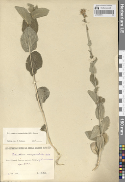
LE 01290516
Asyneuma campanuloides (M. Bieb. ex Sims) Bornm. det. Fedorov, Andrey Aleksandrovich at 1954
Collectors: Busch, Elizaveta Aleksandrovna; Busch, Nikolai Adolfovich (Nikolaj Adolfowitsch) Collection date: 01.08.1933. Subregion: South Ossetia. Groups of specimens: Образцы сектора Кавказа; Соглашение Минобрнауки №075-15-2021-1056Original label text:Бассейн Малой Лиахвы. Верховья, Пачуры [= Пачурисцкали], субальпийский луг. 2000 м.
Coordinates (geographic position): 42° 23′ 54.85″ N, 44° 19′ 56.43″ E 2000 m a.s.l.Comment: 1.VIII.1933
Е. и Н. Буш
The Malaya Liakhva basin. Upper reaches, Pachur [= Pachuristskali], subalpine meadow. 2000 m.
01.08.1933Coll. E. Busch, N. Busch