View
Add
Copy
Edit
Delete
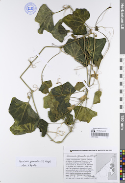
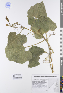
LE 01195035
Coccinia grandis (L.) Voigt det. Byalt, Vyacheslav Vyacheslavovich
Collectors: Byalt, Vyacheslav Vyacheslavovich; Korshunov, Mikhail Vladimirovich Field collecting number: 2945. Collection date: 15.05.2020. Administrative regions: AE - United Arab Emirates. Place of collection: Fujairah Emirate, Al Bidiya, Al Qalamoon Nursery, 0.3 km East from Eid Prayer Ground Bidyah [point 781]: weed without irrigation on abandoned land anong fence, on tree trunks and on bushes.Groups of specimens: Образцы общего сектора; Соглашение Минобрнауки №075-15-2021-1056; Бялт В.В.: Флора ФуджейрыOriginal label text: United Arab Emirates, Fujairah Emirate, Al Bidiya, Al Qalamoon Nursery, 0.3 km East from Eid Prayer Ground Bidyah, 25°25'24.70"N, 56°20'18.77"E, Elevation 22 m [point 781]: weed without irrigation on abandoned land anong fence, on tree trunks and on bushes, 15 V 2020, veg., fl., V.V. Byalt, M.V. Korshunov 2945
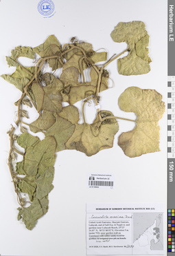
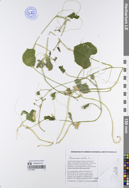
LE 01195034
Cucurbita maxima Duchesne det. Byalt, Vyacheslav Vyacheslavovich
Collectors: Byalt, Vyacheslav Vyacheslavovich; Korshunov, Mikhail Vladimirovich Field collecting number: 2098. Collection date: 14.04.2020. Administrative regions: AE - United Arab Emirates. Place of collection: Sharjah Emirate, Luluyah, end of Safi Esa Al Naqbi st. and gardens near Luluyah Beach [point 753]: near garden wall on wasteland.Groups of specimens: Образцы общего сектора; Соглашение Минобрнауки №075-15-2021-1056; Бялт В.В.: Флора ФуджейрыOriginal label text: United Arab Emirates, Sharjah Emirate, Luluyah, end of Safi Esa Al Naqbi st. and gardens near Luluyah Beach. 25°23'24.43"N, 56°21'40.92"E, elevation 5 m. [point 753]: near garden wall on wasteland, 14 IV 2020, fl.,V.V. Byalt, M.V. Korshunov 2098
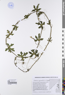
LE 01195033
Coccinia grandis (L.) Voigt det. Byalt, Vyacheslav Vyacheslavovich
Collectors: Byalt, Vyacheslav Vyacheslavovich; Korshunov, Mikhail Vladimirovich Field collecting number: 3552 (7). Collection date: 13.06.2020. Administrative regions: AE - United Arab Emirates. Place of collection: Fujarah Emirate, Al Dibba town, Alamarey Nursery, 0.5 km South from Khalid Hadi Resort Dibba [point 797]: weed under tree, on the garden fence, near wall, on the agricultural waste.Groups of specimens: Образцы общего сектора; Соглашение Минобрнауки №075-15-2021-1056; Бялт В.В.: Флора ФуджейрыOriginal label text: United Arab Emirates, Fujarah Emirate, Al Dibba town, Alamarey Nursery, 0.5 km South from Khalid Hadi Resort Dibba. 25°34'33.97"N, 56°14'6.15"E, Elevation 45 m [point 797]: weed under tree, on the garden fence, near wall, on the agricultural waste, 13 VI 2020, veg., V.V. Byalt, M.V. Korshunov 3552 (7)
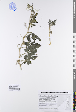
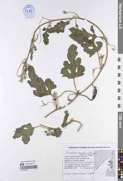
LE 01195032
Citrullus lanatus (Thunb.) Matsum. & Nakai det. Byalt, Vyacheslav Vyacheslavovich
Collectors: Byalt, Vyacheslav Vyacheslavovich; Korshunov, Mikhail Vladimirovich Field collecting number: 2178. Collection date: 17.04.2020. Administrative regions: AE - United Arab Emirates. Place of collection: Rul Dhadna, gardens 0.5 km to East from Dhadna Port [point 754]: weed in gravel-sand wadi near gardens on household and agricultural trash.Groups of specimens: Образцы общего сектора; Соглашение Минобрнауки №075-15-2021-1056; Бялт В.В.: Флора ФуджейрыOriginal label text: United Arab Emirates, Emirate, Rul Dhadna, gardens 0.5 km to East from Dhadna Port, 25°31'26.73"N, 56°21'53.68"E, elevation 6 m [point 754]: weed in gravel-sand wadi near gardens on household and agricultural trash, 17 IV 2020, V.V. Byalt, M.V. Korshunov 2178
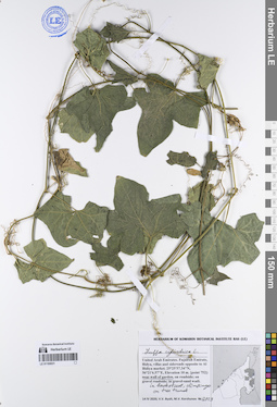
LE 01195031
Luffa cylindrica (L.) M. Roem. det. Byalt, Vyacheslav Vyacheslavovich
Collectors: Byalt, Vyacheslav Vyacheslavovich; Korshunov, Mikhail Vladimirovich Field collecting number: 2129. Collection date: 14.04.2020. Administrative regions: AE - United Arab Emirates. Place of collection: Fujairah Emirate, Bidya, villas and sideroads opposite to Al Bidiya market [point 752]: near wall of garden, in backstreet, climbing on tree trunk.Groups of specimens: Образцы общего сектора; Соглашение Минобрнауки №075-15-2021-1056; Бялт В.В.: Флора ФуджейрыOriginal label text: United Arab Emirates, Fujairah Emirate, Bidya, villas and sideroads opposite to Al Bidiya market. 25°25'57.34"N, 56°21'6.57"E, elevation 10 m. [point 752]: near wall of garden, in backstreet, climbing on tree trunk, 14 IV 2020, veg., V.V. Byalt, M.V. Korshunov 2129
LE 01195030
Citrullus lanatus (Thunb.) Matsum. & Nakai det. Byalt, Vyacheslav Vyacheslavovich
Collectors: Byalt, Vyacheslav Vyacheslavovich; Korshunov, Mikhail Vladimirovich Field collecting number: 2108. Collection date: 14.04.2020. Administrative regions: AE - United Arab Emirates. Place of collection: Fujairah Emirate, Bidya, villas and sideroads opposite to Al Bidiya market [point 752]: on roadside in backstreet.Groups of specimens: Образцы общего сектора; Соглашение Минобрнауки №075-15-2021-1056; Бялт В.В.: Флора ФуджейрыOriginal label text: United Arab Emirates, Fujairah Emirate, Bidya, villas and sideroads opposite to Al Bidiya market. 25°25'57.34"N, 56°21'6.57"E, elevation 10 m. [point 752]: on roadside in backstreet, 14 IV 2020, V.V. Byalt, M.V. Korshunov 2108
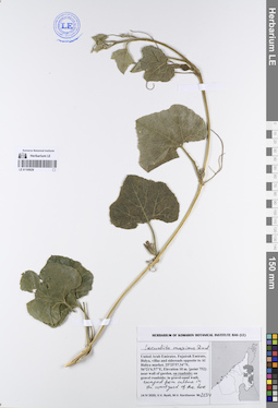
LE 01195029
Cucurbita maxima Duchesne det. Byalt, Vyacheslav Vyacheslavovich
Collectors: Byalt, Vyacheslav Vyacheslavovich; Korshunov, Mikhail Vladimirovich Field collecting number: 2134. Collection date: 14.04.2020. Administrative regions: AE - United Arab Emirates. Place of collection: Fujairah Emirate, Bidya, villas and sideroads opposite to Al Bidiya market [point 752]: escaped from the culture in the courtyard of the house and on roadside.Groups of specimens: Образцы общего сектора; Соглашение Минобрнауки №075-15-2021-1056; Бялт В.В.: Флора ФуджейрыOriginal label text: United Arab Emirates, Fujairah Emirate, Bidya, villas and sideroads opposite to Al Bidiya market. 25°25'57.34"N, 56°21'6.57"E, elevation 10 m. [point 752]: escaped from the culture in the courtyard of the house and on roadside, 14 IV 2020, fr. juv., V.V. Byalt, M.V. Korshunov 2134

LE 01195028
Momordica charantia L. det. Byalt, Vyacheslav Vyacheslavovich
Collectors: Byalt, Vyacheslav Vyacheslavovich; Korshunov, Mikhail Vladimirovich Field collecting number: 2211. Collection date: 17.04.2020. Administrative regions: AE - United Arab Emirates. Place of collection: Fujairah Emirate, Rul Dhadna, villas and accommodations north from Mina road, on corner with E99 Rugaylat road [point 755]: in dranaige and on wasteland between villas, behind the store.Groups of specimens: Образцы общего сектора; Соглашение Минобрнауки №075-15-2021-1056; Бялт В.В.: Флора ФуджейрыOriginal label text: United Arab Emirates. Fujairah Emirate, Rul Dhadna, villas and accommodations north from Mina road, on corner with E99 Rugaylat road. 25°31'16.29"N, 56°21'19.69"E, elevation 12 m [pont 755]: in dranaige and on wasteland between villas, behind the store, 17 IV 2020, veg., V.V. Byalt, fl., M.V. Korshunov 2211
LE 01195027
Cucumis melo L. det. Byalt, Vyacheslav Vyacheslavovich
Collectors: Byalt, Vyacheslav Vyacheslavovich; Korshunov, Mikhail Vladimirovich Field collecting number: 1375. Collection date: 21.11.2019. Administrative regions: AE - United Arab Emirates. Place of collection: Фуджейра, г. Дибба, сады в юго-восточной части города и прилегающие улочки: сорное в тенистом переулке у садов.Groups of specimens: Образцы общего сектора; Соглашение Минобрнауки №075-15-2021-1056; Бялт В.В.: Флора ФуджейрыOriginal label text: United Arab Emirates. Emirate of Fujaira, Dibba, 25°36'46.39"N 56°16'07.85"E, 10 m alt., gardens in SE part and adjacent streets: weed on ырфвн backstreet side near gardens. – ОАЭ, Фуджейра, Дибба, 25°36'46.39"N 56°16'07.85"E, 10 м н.ур.м., сады в юго-восточной части города и прилегающие улочки: сорняк в тенистом переулке у садов, 21 XI 2019, fl., V.V. Byalt, M.V. Korshunov 1375
LE 01195026
Lagenaria siceraria (Molina) Standl. det. Byalt, Vyacheslav Vyacheslavovich
Collectors: Byalt, Vyacheslav Vyacheslavovich; Korshunov, Mikhail Vladimirovich Field collecting number: 2229. Collection date: 17.04.2020. Administrative regions: AE - United Arab Emirates. Place of collection: Fujairah Emirate, Rul Dhadna, villas and accommodations north from Mina road, on corner with E99 Rugaylat road [point 755]: on wasteland between villas and behind the store.Groups of specimens: Образцы общего сектора; Соглашение Минобрнауки №075-15-2021-1056; Бялт В.В.: Флора ФуджейрыOriginal label text: United Arab Emirates. Fujairah Emirate, Rul Dhadna, villas and accommodations north from Mina road, on corner with E99 Rugaylat road. 25°31'16.29"N, 56°21'19.69"E, elevation 12 m [pont 755]: on wasteland between villas and behind the store, 17 IV 2020, V.V. Byalt, fl., M.V. Korshunov 2229
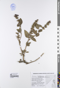
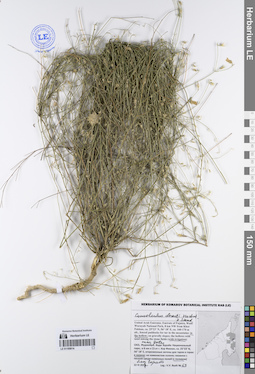
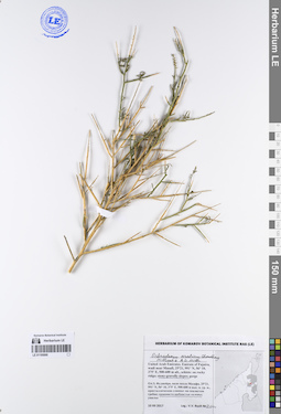
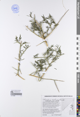
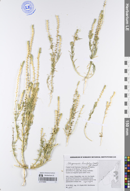
LE 01195025
Salvia macilenta Boiss. det. Byalt, Vyacheslav Vyacheslavovich
Additional identifications: Salvia aegyptiaca L. det. Byalt, Vyacheslav Vyacheslavovich Collectors: Byalt, Vyacheslav Vyacheslavovich Field collecting number: 50. Collection date: 21.03.2017. Administrative regions: AE - United Arab Emirates. Place of collection: Фуджейра, Вади Вурайа Национальный парк, в 8 км северо-западнее г. Хор Факкан, выше водопада: уступы скал и гравий.Groups of specimens: Образцы общего сектора; Соглашение Минобрнауки №075-15-2021-1056; Бялт В.В.: Флора ФуджейрыOriginal label text: United Arab Emirates. Emirate of Fujaira, Wadi Wurayah National Park, 8 km NW from Khor Fakkan, 25°23’46” N, 56° 16’ 10” E, 170-250 m alt., wadi upper waterfall: on rocks and gravel.– ОАЭ, Фуджейра, Вади Вурайа Национальный парк, в 8 км к СЗ от г. Хор Факкан, 25°23’46” N, 56° 16’ 10” E, 170-250 м н.ур.м., выше водопада: на уступах скал и на гравии, 21 III 2017, V.V. Byalt 50
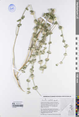
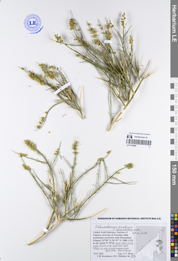
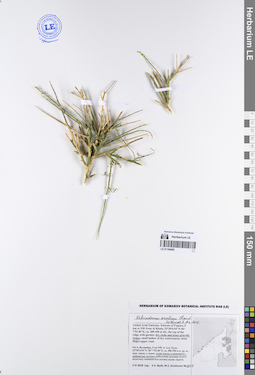
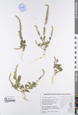
LE 01195024
Lavandula subnuda Benth. det. Byalt, Vyacheslav Vyacheslavovich
Collectors: Byalt, Vyacheslav Vyacheslavovich Field collecting number: 32. Collection date: 21.03.2017. Administrative regions: AE - United Arab Emirates. Place of collection: Фуджейра, Вади Вурайа Национальный парк, в 8 км северо-западнее г. Хор Факкан, выше водопада: на уступах скал и на гравии.Groups of specimens: Образцы общего сектора; Соглашение Минобрнауки №075-15-2021-1056; Бялт В.В.: Флора ФуджейрыOriginal label text: United Arab Emirates. Emirate of Fujaira, Wadi Wurayah National Park, 8 km NW from Khor Fakkan, 25°23’46” N, 56° 16’ 10” E, 170–250 m alt., wadi upper waterfall: on rocks and gravel.– ОАЭ, Фуджейра, Вади Вурайа Национальный парк, в 8 км к СЗ от г. Хор Факкан, 25°23’46” N, 56° 16’ 10” E, 170–250 м н.ур.м., выше водопада: на уступах скал и на гравии, 21 III 2017, V.V. Byalt 32
LE 01195023
Ocimum basilicum L. det. Byalt, Vyacheslav Vyacheslavovich
Collectors: Byalt, Vyacheslav Vyacheslavovich Field collecting number: 1344. Collection date: 29.03.2018. Administrative regions: AE - United Arab Emirates. Place of collection: Фуджейра, г. Фуджейра, район города близ аэропорта, культивируется в парке у Правительства Фуджейры.Groups of specimens: Образцы общего сектора; Соглашение Минобрнауки №075-15-2021-1056; Бялт В.В.: Флора ФуджейрыOriginal label text: United Arab Emirates. Emirate of Fujaira, center part city of Al Fujeira, 25°07'17"N 56°20'12"E: cultivated in park near Government of Fujaira.– ОАЭ, Фуджейра, г. Фуджейра, район города близ аэропорта, 25°07'17"N 56°20'12"E: культивируется в парке у Правительства Фуджейры, 29 III 2018, V.V. Byalt 1344
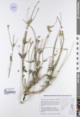
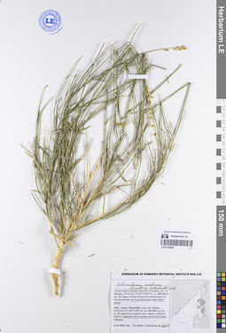
LE 01195022
Teucrium stocksianum Boiss. det. Byalt, Vyacheslav Vyacheslavovich
Collectors: Byalt, Vyacheslav Vyacheslavovich; Korshunov, Mikhail Vladimirovich Field collecting number: 1343. Collection date: 26.03.2018. Administrative regions: AE - United Arab Emirates. Place of collection: Фуджейра, Вади Вурайа Национальный парк, в 8 км северо-западнее г. Хор Факкан, верхняя часть отрогов вади: дно вади, небольшие отроги.Groups of specimens: Образцы общего сектора; Соглашение Минобрнауки №075-15-2021-1056; Бялт В.В.: Флора ФуджейрыOriginal label text: United Arab Emirates. Emirate of Fujaira, Wadi Wurayah National Park, 15-16 km NW from Khor Fakkan, ca. 25°23’ N, 56° 18’ E, upper part of lateral wadi: wadi bottom (lateral gorge).– ОАЭ, Фуджейра, Вади Вурайа Национальный парк, в 8 км к СЗ от г. Хор Факкан, ca. 25°23’ N, 56° 18’ E, верхняя часть отрогов вади: дно вади, неболь. отроги, 26 III 2018 Leg.: V.V. Byalt, M.V. Korshunov 1343
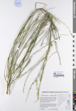
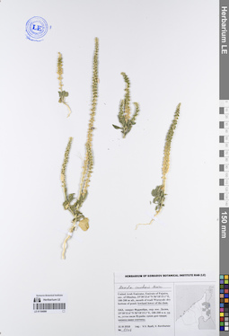
LE 01195021
Lavandula subnuda Benth. det. Byalt, Vyacheslav Vyacheslavovich
Collectors: Byalt, Vyacheslav Vyacheslavovich; Korshunov, Vladimir Mikhailovich Field collecting number: 1342. Collection date: 31.03.2018. Administrative regions: AE - United Arab Emirates. Place of collection: эмират Фуджейра, окрестности пос. Дадна, западный край Вади Вурайя национального парка: каменистый и скалистый склон выше ущелья.Groups of specimens: Образцы общего сектора; Соглашение Минобрнауки №075-15-2021-1056; Бялт В.В.: Флора ФуджейрыOriginal label text: United Arab Emirates. Emirate of Fujaira, env. of Dhadna, 25°31'02.2"N 56°17'50.5"E, ca. 200-300 m alt., W edege of Wadi Wurayah national park: on stony and rocky slope upper gorge. – ОАЭ, эмират Фуджейра, окр. пос. Дадна, 25°31'02.2"N 56°17'50.5"E, ca. 200-300 м н. ур. м., W край Вади вурайя нац. парка: каменистый и скалистый склон выше ущелья, 31 III 2018, V.V. Byalt, V. Korshunov 1342
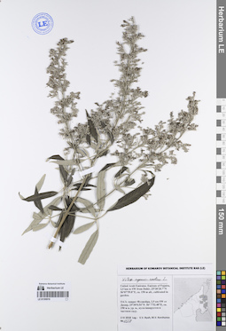
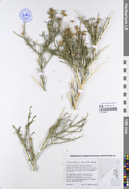
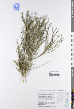
LE 01195020
Salvia macilenta Boiss. det. Byalt, Vyacheslav Vyacheslavovich
Collectors: Byalt, Vyacheslav Vyacheslavovich; Korshunov, Mikhail Vladimirovich Field collecting number: 1340. Collection date: 26.03.2018. Administrative regions: AE - United Arab Emirates. Place of collection: Фуджейра, Вади Вурайа Национальный парк, в 8 км северо-западнее г. Хор Факкан, верхняя часть отрогов вади: щебнисто-каменистые склоны, дно промоины.Groups of specimens: Образцы общего сектора; Соглашение Минобрнауки №075-15-2021-1056; Бялт В.В.: Флора ФуджейрыOriginal label text: United Arab Emirates. Emirate of Fujaira, Wadi Wurayah National Park, 15-16 km NW from Khor Fakkan, ca. 25°23’ N, 56° 18’ E, upper part of lateral wadi: gravelly-stony slopes.– ОАЭ, Фуджейра, Вади Вурайа Национальный парк, в 8 км к СЗ от г. Хор Факкан, ca. 25°23’ N, 56° 18’ E, верхняя часть отрогов вади: щебнисто-каменистые склоны, дно промоины, 26 III 2018 Leg.: V.V. Byalt, M.V. Korshunov 1340
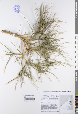
LE 01195019
Lavandula subnuda Benth. det. Byalt, Vyacheslav Vyacheslavovich
Collectors: Byalt, Vyacheslav Vyacheslavovich; Korshunov, Vladimir Mikhailovich Field collecting number: 1341. Collection date: 31.03.2018. Administrative regions: AE - United Arab Emirates. Place of collection: эмират Фуджейра, окрестности пос. Дадна, западный край Вади Вурайя национального парка: глубокое ущелье.Groups of specimens: Образцы общего сектора; Соглашение Минобрнауки №075-15-2021-1056; Бялт В.В.: Флора ФуджейрыOriginal label text: United Arab Emirates. Emirate of Fujaira, env. of Dhadna, 25°31'02.2"N 56°17'50.5"E, ca. 200–300 m alt., W edege of Wadi Wurayah national park: in the deep gorge. – ОАЭ, эмират Фуджейра, окр. пос. Дадна, 25°31'02.2"N 56°17'50.5"E, ca. 200-300 м н. ур. м., W край Вади вурайя нац. парка: глубокое ущелье, 31 III 2018, V.V. Byalt, V. Korshunov 1341
LE 01195018
Ocimum tenuiflorum L. det. Byalt, Vyacheslav Vyacheslavovich
Additional identifications: Ocimum basilicum L. det. Byalt, Vyacheslav Vyacheslavovich; Ocimum sanctum L. det. Byalt, Vyacheslav Vyacheslavovich Collectors: Byalt, Vyacheslav Vyacheslavovich Field collecting number: 1345. Collection date: 30.03.2018. Administrative regions: AE - United Arab Emirates. Place of collection: Эмират Фуджейра, г. Фуджейра, район города близ аэропорта, в пальмовом саду у жилого дома, культивируется.Groups of specimens: Образцы общего сектора; Соглашение Минобрнауки №075-15-2021-1056; Бялт В.В.: Флора ФуджейрыOriginal label text: United Arab Emirates. Emirate of Fujairah, city of Al Fujeira, near airport, 25°07'11.8"N, 56°19'49.3"E, in palm garden near home; cultivated.– ОАЭ, Эмират Фуджейра, г. Фуджейра, район города близ аэропорта, 25°07'11.8"N, 56°19'49.3"E, в пальмовом саду у жилого дома, культивируется, 30 III 2018, V.V. Byalt 1345
LE 01195017
Leucas inflata Benth. det. Byalt, Vyacheslav Vyacheslavovich
Collectors: Byalt, Vyacheslav Vyacheslavovich; Korshunov, Mikhail Vladimirovich Field collecting number: 1339. Collection date: 26.03.2018. Administrative regions: AE - United Arab Emirates. Place of collection: Фуджейра, Вади Вурайа Национальный парк, в 8 км северо-западнее г. Хор Факкан, верхняя часть отрогов вади: щебнисто-каменистые склоны.Groups of specimens: Образцы общего сектора; Соглашение Минобрнауки №075-15-2021-1056; Бялт В.В.: Флора ФуджейрыOriginal label text: United Arab Emirates. Emirate of Fujaira, Wadi Wurayah National Park, 15-16 km NW from Khor Fakkan, ca. 25°23’ N, 56° 18’ E, upper part of lateral wadi: gravelly-stony slopes.– ОАЭ, Фуджейра, Вади Вурайа Национальный парк, в 8 км к СЗ от г. Хор Факкан, ca. 25°23’ N, 56° 18’ E, верхняя часть отрогов вади: щебнисто-каменистые склоны, 26 III 2018 Leg.: V.V. Byalt, M.V. Korshunov 1339
LE 01195016
Vitex agnus-castus L. det. Byalt, Vyacheslav Vyacheslavovich
Collectors: Byalt, Vyacheslav Vyacheslavovich; Korshunov, Mikhail Vladimirovich Field collecting number: 1338. Collection date: 02.04.2018. Administrative regions: AE - United Arab Emirates. Place of collection: эмират Фуджейра, 2,5 км юго-западнее Дахир, культивируется в частном саду.Groups of specimens: Образцы общего сектора; Соглашение Минобрнауки №075-15-2021-1056; Бялт В.В.: Флора ФуджейрыOriginal label text: United Arab Emirates. Emirate of Fujaira, 2,5 km to SW from Dahir, 25°30'28.7"N 56°07'59.8"E, ca. 150 m alt., cultivated in garden.– ОАЭ, эмират Фуджейра, 2,5 км SW от Дахир, 25°30'0.54"N 56° 7'52.40"E, ca. 150 м н. ур. м., культивируется в частном саду, 2 IV 2018, V.V. Byalt, M.V. Korshunov 1338
LE 01195015
Mentha × piperita L. det. Byalt, Vyacheslav Vyacheslavovich
Collectors: Byalt, Vyacheslav Vyacheslavovich Field collecting number: 1338 bis. Collection date: 29.03.2018. Administrative regions: AE - United Arab Emirates. Place of collection: Фуджейра, г. Фуджейра, район города близ аэропорта, культивируется в парке у Правительства Фуджейры.Groups of specimens: Образцы общего сектора; Соглашение Минобрнауки №075-15-2021-1056; Бялт В.В.: Флора ФуджейрыOriginal label text: United Arab Emirates. Emirate of Fujaira, center part city of Al Fujeira, 25°07'17"N 56°20'12"E: cultivated in park near Government of Fujaira.– ОАЭ, Фуджейра, г. Фуджейра, район города близ аэропорта, 25°07'17"N 56°20'12"E: культивируется в парке у Правительства Фуджейры, 29 III 2018, V.V. Byalt 1338 bis
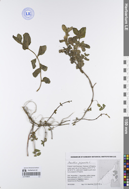
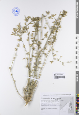
LE 01195014
Convolvulus deserti Hochst. et Steud. det. Byalt, Vyacheslav Vyacheslavovich
Collectors: Byalt, Vyacheslav Vyacheslavovich Field collecting number: 68. Collection date: 22.03.2017. Administrative regions: AE - United Arab Emirates. Place of collection: Фуджейра, Вади Вурайа Национальный парк, в 8 км северо-западнее г. Хор Факкан, огороженные загоны для таров в горах: в низине с поливом, близ ворот.Groups of specimens: Образцы общего сектора; Соглашение Минобрнауки №075-15-2021-1056; Бялт В.В.: Флора ФуджейрыOriginal label text: United Arab Emirates. Emirate of Fujaira, Wadi Wurayah National Park, 8 km NW from Khor Fakkan, ca. 25°23’ N, 56° 18’ E, ca. 160–170 m alt., fenced paddocks for tar in the mountains: in the hollow with irrigation, near gates. – ОАЭ, Фуджейра, Вади Вурайа Национальный парк, в 8 км к СЗ от г. Хор Факкан, ca. 25°23’ N, 56° 18’ E, огороженные загоны для таров в горах: в низине с поливом, близ ворот, 22 III 2017, V.V. Byalt 68
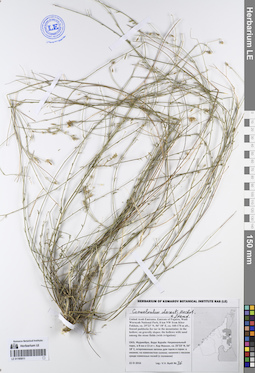
LE 01195013
Convolvulus deserti Hochst. et Steud. det. Byalt, Vyacheslav Vyacheslavovich
Collectors: Byalt, Vyacheslav Vyacheslavovich; Korshunov, Mikhail Vladimirovich Field collecting number: 156. Collection date: 11.03.2020. Administrative regions: AE - United Arab Emirates. Place of collection: Fujairah Emirate, 2.5 km East-North-East to Al Hayl Fort (Al Hayl Castle) [point 705]: on gravel and stone roadside near gardens.Groups of specimens: Образцы общего сектора; Соглашение Минобрнауки №075-15-2021-1056; Бялт В.В.: Флора ФуджейрыOriginal label text: United Arab Emirates, Fujairah Emirate, 2.5 km East-North-East to Al Hayl Fort (Al Hayl Castle).
25°5'32.42"N, 56°14'56.50"E, elevation 145 m [point 705]: on gravel and stone roadside near gardens, 11 III 2020, V.V. Byalt, M.V. Korshunov 156

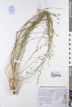
LE 01195012
Convolvulus deserti Hochst. et Steud. det. Byalt, Vyacheslav Vyacheslavovich
Collectors: Byalt, Vyacheslav Vyacheslavovich; Korshunov, Mikhail Vladimirovich Field collecting number: 1059. Collection date: 04.04.2018. Administrative regions: AE - United Arab Emirates. Place of collection: Фуджейра, пос. Аль Бидия, пустырь на окраине.Groups of specimens: Образцы общего сектора; Соглашение Минобрнауки №075-15-2021-1056; Бялт В.В.: Флора ФуджейрыOriginal label text: United Arab Emirates. Emirate of Fujaira, village Al Bidiyah, 25°26'13" N, 56°20'2" Е: on the wasteland near village. – ОАЭ, Фуджейра, посёлок Аль Бидия, 25°26'13" N, 56°20'2" Е: пустырь на окраине, 3–4 IV 2018 Leg.: V.V. Byalt, M.V. Korshunov 1059
LE 01195011
Convolvulus deserti Hochst. et Steud. det. Byalt, Vyacheslav Vyacheslavovich
Collectors: Byalt, Vyacheslav Vyacheslavovich Field collecting number: 76. Collection date: 22.03.2017. Administrative regions: AE - United Arab Emirates. Place of collection: Фуджейра, Вади Вурайа Национальный парк, в 8 км северо-западнее г. Хор Факкан, огороженные загоны для таров в горах: в низине; на каменистом склоне; низинки с песком среди каменных полей (с поливом).Groups of specimens: Образцы общего сектора; Соглашение Минобрнауки №075-15-2021-1056; Бялт В.В.: Флора ФуджейрыOriginal label text: United Arab Emirates. Emirate of Fujaira, Wadi Wurayah National Park, 8 km NW from Khor Fakkan, ca. 25°23’ N, 56° 18’ E, ca. 160–170 m alt., fenced paddocks for tar in the mountains: in the hollow; on gravelly slopes; the hollows with sand among the stone fields (with irrigation). – ОАЭ, Фуджейра, Вади Вурайа Национальный парк, в 8 км к СЗ от г. Хор Факкан, ca. 25°23’ N, 56° 18’ E, огороженные загоны для таров в горах: в низине; на каменистом склоне; низинки с песком среди каменных полей (с поливом), 22 III 2017, V.V. Byalt 76

LE 01195010
Convolvulus deserti Hochst. et Steud. det. Byalt, Vyacheslav Vyacheslavovich
Collectors: Byalt, Vyacheslav Vyacheslavovich Field collecting number: 663. Collection date: 14.12.2017. Administrative regions: AE - United Arab Emirates. Place of collection: Фуджейра, пос. Аль Бидия, окрестности г. Фуджейра, около плотины, сухое дно пруда выше плотины.Groups of specimens: Образцы общего сектора; Соглашение Минобрнауки №075-15-2021-1056; Бялт В.В.: Флора ФуджейрыOriginal label text: United Arab Emirates. Emirate of Fujaira, environs of Al Fujeira, near dam, 25° 8' 24.34" N, 56°18'39.14"E: dry bottom of pond upper dam.– ОАЭ, Фуджейра, посёлок Аль Бидия, окр. г. Фуджейра, около плотины, 25° 8' 24.34" N, 56°18'39.14"E: сухое дно пруда выше плотины, 14 XII 2017, V.V. Byalt 663
LE 01195009
Convolvulus deserti Hochst. et Steud. det. Byalt, Vyacheslav Vyacheslavovich
Collectors: Byalt, Vyacheslav Vyacheslavovich; Korshunov, Vladimir Mikhailovich Field collecting number: 270. Collection date: 31.03.2018. Administrative regions: AE - United Arab Emirates. Place of collection: эмират Фуджейра, окрестности пос. Дадна, западный край Вади Вурайя национального парка: глубокое ущелье: между валунов.Groups of specimens: Образцы общего сектора; Соглашение Минобрнауки №075-15-2021-1056; Бялт В.В.: Флора ФуджейрыOriginal label text: United Arab Emirates. Emirate of Fujaira, env. of Dhadna, 25°31'02.2"N 56°17'50.5"E, ca. 200–300 m alt., W edege of Wadi Wurayah national park: in the deep gorge: between big stones. – ОАЭ, эмират Фуджейра, окр. пос. Дадна, 25°31'02.2"N 56°17'50.5"E, ca. 150–300 м н. ур. м., W край Вади вурайя нац. парка: глубокое ущель: между валунов, 31 III 2018, V.V. Byalt, V. Korshunov 270
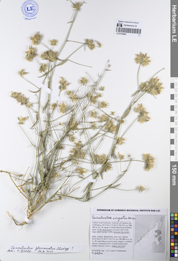
LE 01195008
Convolvulus virgatus Boiss. det. Byalt, Vyacheslav Vyacheslavovich
Additional identifications: Convolvulus glomeratus Choiry det. Byalt, Vyacheslav Vyacheslavovich at 16.09.2022 Collectors: Byalt, Vyacheslav Vyacheslavovich; Korshunov, Vladimir Mikhailovich Field collecting number: 269a. Collection date: 31.03.2018. Administrative regions: AE - United Arab Emirates. Place of collection: эмират Фуджейра, окрестности пос. Дадна, западный край Вади Вурайя национального парка: глубокое ущелье, между валунов.Groups of specimens: Образцы общего сектора; Соглашение Минобрнауки №075-15-2021-1056; Бялт В.В.: Флора ФуджейрыOriginal label text: United Arab Emirates. Emirate of Fujaira, env. of Dhadna, 25°31′02.2″ N 56°17′50.5″ E, ca. 200—300 m alt., W edege of Wadi Wurayah national park: in the deep gorge, between big stones. — ОАЭ, эмират Фуджейра, окр. пос. Дадна, 25°31′02.2″ N, 56°17′50.5″ E, ca. 200—300 м над ур. моря, W край Вади вурайя нац. парка: глубокое ущелье, между валунов, 31 III 2018, fl., fr., V. V. Byalt, V. Korshunov 269a
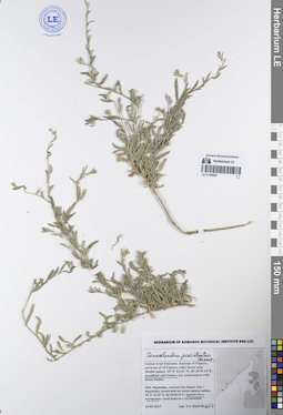
LE 01195007
Convolvulus prostratus Forssk. det. Byalt, Vyacheslav Vyacheslavovich
Collectors: Byalt, Vyacheslav Vyacheslavovich Field collecting number: 657. Collection date: 14.12.2017. Administrative regions: AE - United Arab Emirates. Place of collection: Фуджейра, пос. Аль Бидия, окрестности г. Фуджейра, реликтовый лес около дворца шейха, редкий лес и кустарники.Groups of specimens: Образцы общего сектора; Соглашение Минобрнауки №075-15-2021-1056; Бялт В.В.: Флора ФуджейрыOriginal label text: United Arab Emirates. Emirate of Fujaira, environs of Al Fujeira, relict forest near Sheikh palace, 25°8′24.34″ N, 56°18′39.14″ E: woodland and bushes. — ОАЭ, Фуджейра, поселок Аль Бидия, окр. г. Фуджейра, реликтовый лес около дворца шейха, 25°8′24.34″ N, 56°18′39.14″ E: редкий лес и кустарники, 14 XII 2017, V. V. Byalt 657
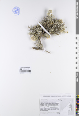
LE 01195006
Convolvulus ulcinus Boiss. det. Byalt, Vyacheslav Vyacheslavovich
Collectors: Byalt, Vyacheslav Vyacheslavovich; Korshunov, Mikhail Vladimirovich Field collecting number: 476. Collection date: 13.03.2020. Administrative regions: AE - United Arab Emirates. Place of collection: Fujairah Emirate, Al Tawyeen (Taween) area, small village 0.8 km West-North-West to mountain peak. 25°38'59.41"N, 56° 7'17.88"E, elevation 1360 m. [point 707]: on mountain rock ledges and plateau.Groups of specimens: Образцы общего сектора; Соглашение Минобрнауки №075-15-2021-1056; Бялт В.В.: Флора ФуджейрыOriginal label text: United Arab Emirates, Fujairah Emirate, Al Tawyeen (Taween) area, small village 0.8 km West-North-West to mountain peak. 25°38'59.41"N, 56° 7'17.88"E, elevation 1360 m. [point 707]: on mountain rock ledges and plateau, 13 III 2020, V.V. Byalt, M.V. Korshunov 476
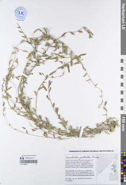
LE 01195005
Convolvulus prostratus Forssk. det. Byalt, Vyacheslav Vyacheslavovich
Collectors: Byalt, Vyacheslav Vyacheslavovich; Korshunov, Mikhail Vladimirovich Field collecting number: 1591=1614. Collection date: 24.11.2019. Administrative regions: AE - United Arab Emirates. Place of collection: Фуджейра, Аль Тайба в окрестности г. Фуджейра, сорное в восточной части фермы шейха Хамада II.Groups of specimens: Образцы общего сектора; Соглашение Минобрнауки №075-15-2021-1056; Бялт В.В.: Флора ФуджейрыOriginal label text: United Arab Emirates. Emirate of Fujaira, Al Taiba in environs of the city of Al Fujeira, 25°09′29.6″ N, 56°17′31″ E: weed in irrigated places in E part of farm of the Sheikh Khamad II. — ОАЭ, Фуджейра, Аль Тайба в окр. г. Фуджейра, 25°09′29.6″ N, 56°17′31″ E: сорняк в восточной части фермы шейха Хамада II, 24 XI 2019, fl., V. V. Byalt & M. V. Korshunov 1591
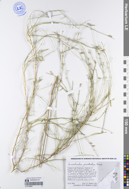
LE 01195004
Convolvulus prostratus Forssk. det. Byalt, Vyacheslav Vyacheslavovich
Collectors: Byalt, Vyacheslav Vyacheslavovich; Korshunov, Mikhail Vladimirovich Field collecting number: 1614=1591. Collection date: 24.11.2019. Administrative regions: AE - United Arab Emirates. Place of collection: Фуджейра, Аль Тайба в окрестности г. Фуджейра, сорное в восточной части фермы шейха Хамада II.Groups of specimens: Образцы общего сектора; Соглашение Минобрнауки №075-15-2021-1056; Бялт В.В.: Флора ФуджейрыOriginal label text: United Arab Emirates. Emirate of Fujaira, Al Taiba in environs of the city of Al Fujeira, 25°09′29.6″ N, 56°17′31″ E: weed in irrigated places in E part of farm of the Sheikh Khamad II. — ОАЭ, Фуджейра, Аль Тайба в окр. г. Фуджейра, 25°09′29.6″ N, 56°17′31″ E: сорняк в восточной части фермы шейха Хамада II, 24 XI 2019, fl., V. V. Byalt & M. V. Korshunov 1614
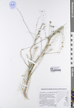
LE 01195003
Convolvulus prostratus Forssk. det. Byalt, Vyacheslav Vyacheslavovich
Collectors: Byalt, Vyacheslav Vyacheslavovich Field collecting number: 672. Collection date: 11.12.2017. Administrative regions: AE - United Arab Emirates. Place of collection: Фуджейра, эмират Фуджейра, окрестности пос. Аль Бидия, водосток возле форта Бидия, засоленная низина между дорогами, обочина дороги.Groups of specimens: Образцы общего сектора; Соглашение Минобрнауки №075-15-2021-1056; Бялт В.В.: Флора ФуджейрыOriginal label text: United Arab Emirates. Emirate of Fujaira, env. of village Al Bidya, drain near Fort Bidya, 25°26'14" N, 56°21'11"E: saline lower place between roads, roadside.– ОАЭ, Фуджейра, эмират Фуджейра, окр. посёлока Аль Бидия, водосток возле форта Бидия. 25°26'14" N, 56°21'11" E: засоленная низина между дорогами, обочина дороги, 11 XII 2017, V.V. Byalt 672
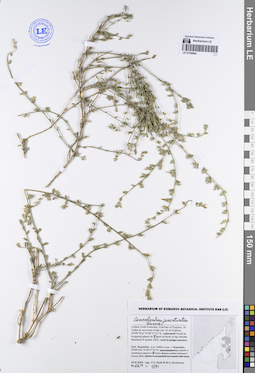
LE 01195002
Convolvulus prostratus Forssk. det. Byalt, Vyacheslav Vyacheslavovich
Collectors: Byalt, Vyacheslav Vyacheslavovich; Korshunov, Vladimir Mikhailovich; Melnikov, Denis Germanovich Field collecting number: 23. Collection date: 14.04.2022. Administrative regions: AE - United Arab Emirates. Place of collection: Emirate of Fujaira, SE environs of Dibba, territory of “Honey Park” [point 2]: over a cascade of dams in the bed of a dry pond.Groups of specimens: Образцы общего сектора; Соглашение Минобрнауки №075-15-2021-1056; Бялт В.В.: Флора ФуджейрыOriginal label text: United Arab Emirates. Emirate of Fujaira, SE environs of Dibba, ca. 25°34.697′ N, 56°16.465′ E, 60—100 м н. ур. м., territory of “Honey Park” [point 2]: over a cascade of dams in the bed of a dry pond, 14 IV 2022, fl., fr., V. V. Byalt, V. M. Korshunov, D. G. Melnikov 23
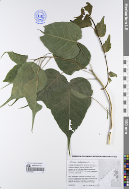
LE 01195001
Ficus johannis Boiss. det. Byalt, Vyacheslav Vyacheslavovich
Collectors: Byalt, Vyacheslav Vyacheslavovich; Korshunov, Mikhail Vladimirovich Field collecting number: 1323. Collection date: 04.04.2018. Administrative regions: AE - United Arab Emirates. Place of collection: Фуджейра, пос. Аль Бидия, сорное на обочине дороги, у забора сада.Groups of specimens: Образцы общего сектора; Соглашение Минобрнауки №075-15-2021-1056; Бялт В.В.: Флора ФуджейрыOriginal label text: United Arab Emirates. Emirate of Fujaira, village Al Bidiyah, 25°26'13" N, 56°20'2"° Е: weed along roadsides (of street), by fence of garden. – ОАЭ, Фуджейра, посёлок Аль Бидия, 25°26'13" N, 56°20'2"° Е: сорняк на обочине дороги, у забора сада, 3–4 IV 2018 Leg.: V.V. Byalt, M.V. Korshunov 1323
LE 01195000
Ochradenus arabicus Chaudhary, Hillc. et A.G.Mill. det. Byalt, Vyacheslav Vyacheslavovich
Collectors: Byalt, Vyacheslav Vyacheslavovich Field collecting number: s.n. Collection date: 10.12.2017. Administrative regions: AE - United Arab Emirates. Place of collection: Фуджейра, вади около пос. Мазафи, скалистый гребень, каменисто-щебнистые склоны.Groups of specimens: Образцы общего сектора; Соглашение Минобрнауки №075-15-2021-1056; Бялт В.В.: Флора ФуджейрыOriginal label text: United Arab Emirates. Emirate of Fujaira, wadi near Musafi, 25°21, 991’ N, 56° 10, 375’ E, 500–600 m alt.: on rocky ridge; stony-gravelly slope.– ОАЭ, Фуджейра, вади около Мазафи, 25°21, 991’ N, 56° 10, 375’ E, 500–600 м выс. н. ур. м.: на скалистом гребне, каменисто-щебнистые склоны, 10 XII 2017, fl. juv., V.V. Byalt s.n.
LE 01194999
Ochradenus arabicus Chaudhary, Hillc. et A.G.Mill. det. Byalt, Vyacheslav Vyacheslavovich
Collectors: Byalt, Vyacheslav Vyacheslavovich; Korshunov, Vladimir Mikhailovich; Melnikov, Denis Germanovich Field collecting number: 113. Collection date: 18.04.2022. Administrative regions: AE - United Arab Emirates. Place of collection: Emirate of Fujaira, environs of Tawaian, high mountains on border with Musandam (Oman) [point 707d]: stony valley of dry creek, between boulders.Groups of specimens: Образцы общего сектора; Соглашение Минобрнауки №075-15-2021-1056; Бялт В.В.: Флора ФуджейрыOriginal label text: United Arab Emirates. Emirate of Fujaira, environs of Tawaian, high mountains on border with Musandam (Oman), 25°38’ N, 56° 07’ E, 1000–1126 m alt. [point 707d]: stony valley of dry creek, between boulders, fr., 18 IV 2022, V.V. Byalt, V.M. Korshunov, D.G. Melnikov 113
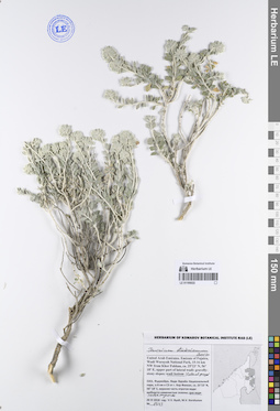
LE 01194998
Ochradenus aucheri Boiss. det. Byalt, Vyacheslav Vyacheslavovich
Collectors: Byalt, Vyacheslav Vyacheslavovich Field collecting number: 158. Collection date: 23.03.2017. Administrative regions: AE - United Arab Emirates. Place of collection: Фуджейра, Вади Вурайа Национальный парк, в 8 км северо-западнее г. Хор Факкан, выше вади: малый боковой вади.Groups of specimens: Образцы общего сектора; Соглашение Минобрнауки №075-15-2021-1056; Бялт В.В.: Флора ФуджейрыOriginal label text: United Arab Emirates. Emirate of Fujaira, Wadi Wurayah National Park, 8 km NW from Khor Fakkan, 25°23, 366’ N, 56° 18, 356’ E, upper wadi: small lateral wadi.– ОАЭ, Фуджейра, Вади Вурайа Национальный парк, в 8 км к СЗ от г. Хор Факкан, 25°23, 366’ N, 56° 18, 356’ E, выше вади: малый боковой вади, 23 III 2017, V.V. Byalt 158
LE 01194997
Ochradenus baccatus Delile det. Byalt, Vyacheslav Vyacheslavovich
Collectors: Byalt, Vyacheslav Vyacheslavovich Field collecting number: 1109. Collection date: 14.12.2017. Administrative regions: AE - United Arab Emirates. Place of collection: Фуджейра, посёлок Аль Бидия, окрестности г. Фуджейра, около плотины, сухое дно пруда выше плотины.Groups of specimens: Образцы общего сектора; Соглашение Минобрнауки №075-15-2021-1056; Бялт В.В.: Флора ФуджейрыOriginal label text: United Arab Emirates. Emirate of Fujaira, environs of Al Fujeira, near dam, 25° 8' 24.34" N, 56°18'39.14"E: dry bottom of pond upper dam.– ОАЭ, Фуджейра, посёлок Аль Бидия, окр. г. Фуджейра, около плотины, 25° 8' 24.34" N, 56°18'39.14"E: сухое дно пруда выше плотины, 14 XII 2017, V.V. Byalt 1109
LE 01194996
Ochradenus arabicus Chaudhary, Hillc. et A.G.Mill. det. Byalt, Vyacheslav Vyacheslavovich
Collectors: Byalt, Vyacheslav Vyacheslavovich Field collecting number: 665. Collection date: 08.12.2017. Administrative regions: AE - United Arab Emirates. Place of collection: Фуджейра, Вади Вурайа Национальный парк, в 8 км северо-западнее г. Хор Факкан, в окрестности и на берегу пруда Hawd al Bid’ah: ущелье выше пруда.Groups of specimens: Образцы общего сектора; Соглашение Минобрнауки №075-15-2021-1056; Бялт В.В.: Флора ФуджейрыOriginal label text: United Arab Emirates. Emirate of Fujaira, Wadi Wurayah National Park, 10 km NW from Khor Fakkan, 25°20'53" N, 56°18'33" E, ca. 250–400 m, environs and banks of pond Hawd al Bid’ah: gorge upper of pond.– ОАЭ, Фуджейра, Вади Вурайа Национальный парк, в 8 км к СЗ от г. Хор Факкан, 25°20'53" N, 56°18'33" E, в окр. и на берегу пруда Hawd al Bid’ah: ущелье выше пруда, 8 XII 2017, fr., V.V. Byalt 80/665
LE 01194995
Ochradenus arabicus Chaudhary, Hillc. et A.G.Mill. det. Byalt, Vyacheslav Vyacheslavovich
Collectors: Byalt, Vyacheslav Vyacheslavovich; Korshunov, Mikhail Vladimirovich Field collecting number: 1113. Collection date: 02.04.2018. Administrative regions: AE - United Arab Emirates. Place of collection: Фуджейра, 5 км северо-западнее пос. Аль Хала, верх гряды с садом: сухие скалы и каменисто-щебнистые склоны.Groups of specimens: Образцы общего сектора; Соглашение Минобрнауки №075-15-2021-1056; Бялт В.В.: Флора ФуджейрыOriginal label text: United Arab Emirates. Emirate of Fujaira, 5 km to NW from Al Khala, 25°30'0.54"N 56° 7'52.40"E, ca. 300-350 m alt., the top of the ridge with garden: dry rocks and stony-gravelly slopes. – ОАЭ, Фуджейра, 5 км NW от Аль Хала, 25°30'0.54"N 56° 7'52.40"E, ca. 300-350 м н. ур. м., верх гряды с садом: сухие скалы и каменисто-щебнистые склоны, 2 IV 2018, V.V. Byalt, M.V. Korshunov 1113
LE 01194994
Ochradenus arabicus Chaudhary, Hillc. et A.G.Mill. det. Byalt, Vyacheslav Vyacheslavovich
Collectors: Byalt, Vyacheslav Vyacheslavovich; Korshunov, Vladimir Mikhailovich Field collecting number: 1108. Collection date: 31.03.2018. Administrative regions: AE - United Arab Emirates. Place of collection: эмират Фуджейра, окрестности пос. Дадна, западный край Вади Вурайя национального парка: каменистый и скалистый склон выше ущелья.Groups of specimens: Образцы общего сектора; Соглашение Минобрнауки №075-15-2021-1056; Бялт В.В.: Флора ФуджейрыOriginal label text: United Arab Emirates. Emirate of Fujaira, env. of Dhadna, 25°31'02.2"N 56°17'50.5"E, ca. 200-300 m alt., W edege of Wadi Wurayah national park: on stony and rocky slope upper gorge. – ОАЭ, эмират Фуджейра, окр. пос. Дадна, 25°31'02.2"N 56°17'50.5"E, ca. 200-300 м н. ур. м., W край Вади Вурайя нац. парка: каменистый и скалистый склон выше ущелья, 31 III 2018, V.V. Byalt, V. Korshunov 1108
LE 01194993
Ochradenus baccatus Delile det. Byalt, Vyacheslav Vyacheslavovich
Collectors: Byalt, Vyacheslav Vyacheslavovich; Korshunov, Mikhail Vladimirovich Field collecting number: 477. Collection date: 13.03.2020. Administrative regions: AE - United Arab Emirates. Place of collection: Fujairah Emirate, Al Tawyeen (Taween) area, small village 0.8 km West-North-West to mountain peak [point 707]: on gravel-stony plateau, among stones.Groups of specimens: Образцы общего сектора; Соглашение Минобрнауки №075-15-2021-1056; Бялт В.В.: Флора ФуджейрыOriginal label text: United Arab Emirates, Fujairah Emirate, Al Tawyeen (Taween) area, small village 0.8 km West-North-West to mountain peak. 25°38'59.41"N, 56° 7'17.88"E, elevation 1360 m. [point 707]: on gravel-stony plateau, among stones, 13 III 2020, V.V. Byalt, M.V. Korshunov 477
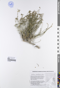
LE 01194992
Oligomeris linifolia (Vahl) J. F. Macbr. det. Byalt, Vyacheslav Vyacheslavovich
Collectors: Byalt, Vyacheslav Vyacheslavovich; Korshunov, Mikhail Vladimirovich Field collecting number: 1115. Collection date: 25.03.2018. Administrative regions: AE - United Arab Emirates. Place of collection: эмират Фуджейра, окрестности пос. Аль Харай, обочина шоссе: в низине и на каменистом склоне выше дороги.Groups of specimens: Образцы общего сектора; Соглашение Минобрнауки №075-15-2021-1056; Бялт В.В.: Флора ФуджейрыOriginal label text: United Arab Emirates. Emirate of Fujaira, environs of Al Haray, 25°23'16.3"N 56°19'02.1"E, roadside: hollow and stony-gravelly slope. – ОАЭ, эмират Фуджейра, окр. пос. Аль Харай, 25°23'16.3"N 56°19'02.1"E, обочина шоссе: в низине и на каменистом склоне выше дороги, 25 III 2018, V.V. Byalt, M.V. Korshunov 1115
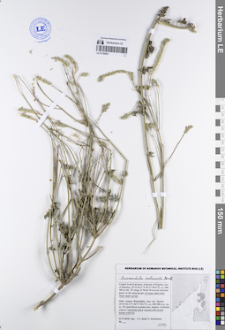
LE 01194991
Reseda aucheri Boiss. det. Byalt, Vyacheslav Vyacheslavovich
Collectors: Byalt, Vyacheslav Vyacheslavovich; Korshunov, Vladimir Mikhailovich Field collecting number: 1105. Collection date: 31.03.2018. Administrative regions: AE - United Arab Emirates. Place of collection: эмират Фуджейра, окрестности пос. Дадна, устье вади Вурайя: сухое дно пруда.Groups of specimens: Образцы общего сектора; Соглашение Минобрнауки №075-15-2021-1056; Бялт В.В.: Флора ФуджейрыOriginal label text: United Arab Emirates. Emirate of Fujaira, env. of Dhadna, 25°30'33.6"N 56°18'15.1"E, 100-200 m alt., mouth of wadi Wurayah: dry bottom of pond. – ОАЭ, эмират Фуджейра, окр. пос. Дадна, 25°30'33.6"N 56°18'15.1"E, 100-200 м н. ур. м., устье вади Вурайя: сухое дно пруда, 31 III 2018, V.V. Byalt, V. Korshunov 1105
LE 01194990
Reseda aucheri Boiss. det. Byalt, Vyacheslav Vyacheslavovich
Collectors: Byalt, Vyacheslav Vyacheslavovich; Korshunov, Vladimir Mikhailovich Field collecting number: 1106. Collection date: 31.03.2018. Administrative regions: AE - United Arab Emirates. Place of collection: эмират Фуджейра, окрестности пос. Дадна, устье вади Вурайя: низина ниже плотины.Groups of specimens: Образцы общего сектора; Соглашение Минобрнауки №075-15-2021-1056; Бялт В.В.: Флора ФуджейрыOriginal label text: United Arab Emirates. Emirate of Fujaira, env. of Dhadna, 25°30'33.6"N 56°18'15.1"E, 100-200 m alt., mouth of wadi Wurayah: lowland lower of the dam. – ОАЭ, эмират Фуджейра, окр. пос. Дадна, 25°30'33.6"N 56°18'15.1"E, 100-200 м н. ур. м., устье вади Вурайя: низина ниже плотины, 31 III 2018, V.V. Byalt, V. Korshunov 1106
LE 01194989
Ochradenus arabicus Chaudhary, Hillc. et A.G.Mill. det. Byalt, Vyacheslav Vyacheslavovich
Collectors: Byalt, Vyacheslav Vyacheslavovich; Korshunov, Vladimir Mikhailovich Field collecting number: 648. Collection date: 06.04.2018. Administrative regions: AE - United Arab Emirates. Place of collection: Фуджейра, 4–5 км северо-западнее пос. Габ, каменистый хребет, по дороге к вышке мобильной связи: сухой ручей.Groups of specimens: Образцы общего сектора; Соглашение Минобрнауки №075-15-2021-1056; Бялт В.В.: Флора ФуджейрыOriginal label text: United Arab Emirates. Emirate of Fujaira, 4–5 km to NW of Ghub, 25°34'18.0"N 56°09'27.9"E, 700–800 m alt., stony ridge, on the way to the mobile tower: dry spring valley. – ОАЭ, Фуджейра, 4–5 км на NW от пос. Габ, 25°34'18.0"N 56°09'27.9"E, 700–800 м н. ур. м., каменистый хребет, по дороге к вышке мобильной связи: сухой ручей, 6 IV 2018, fr., V.V. Byalt, V.M. Korshunov 648
LE 01194988
Ficus religiosa L. det. Byalt, Vyacheslav Vyacheslavovich
Collectors: Byalt, Vyacheslav Vyacheslavovich Field collecting number: 1328. Collection date: 11.12.2017. Administrative regions: AE - United Arab Emirates. Place of collection: Фуджейра, окрестности г. Аль Фуджейра, пос. Бидия, сад директора национального парка Али возле гор Хаджар, сорное в питомнике.Groups of specimens: Образцы общего сектора; Соглашение Минобрнауки №075-15-2021-1056; Бялт В.В.: Флора ФуджейрыOriginal label text: United Arab Emirates. Emirate of Fujaira, env. of Al Fujaira, private garden and nursery of Dr. Ali near Hajar mountains, 25°26'13'' N, 56°20'2'' Е: weed in nursery.– ОАЭ, Фуджейра, окр. г. Аль Фуджейра, посёлок Бидия, сад директора нац. парка Али возле гор Хаджар, 25°26'13'' N, 56°20'2'' Е: сорняк в питомнике, 11 XII 2017, V.V. Byalt 1328

LE 01194987
Ochradenus arabicus Chaudhary, Hillc. et A.G.Mill. det. Byalt, Vyacheslav Vyacheslavovich
Collectors: Byalt, Vyacheslav Vyacheslavovich Field collecting number: 142. Collection date: 11.12.2017. Administrative regions: AE - United Arab Emirates. Place of collection: Фуджейра, окрестности г. Аль Фуджейра, пос. Бидия, сад директора национального парка Али возле гор Хаджар, сорное у забора сада.Groups of specimens: Образцы общего сектора; Соглашение Минобрнауки №075-15-2021-1056; Бялт В.В.: Флора ФуджейрыOriginal label text: United Arab Emirates. Emirate of Fujaira, env. of Al Fujaira, private garden and nursery of Dr. Ali near Hajar mountains, 25°26'13'' N, 56°20'2'' Е: weed near fence of garden / nursery.– ОАЭ, Фуджейра, окр. г. Аль Фуджейра, посёлок Бидия, сад директора нац. парка Али возле гор Хаджар, 25°26'13'' N, 56°20'2'' Е: сорняк у забора сада, 11 XII 2017, V.V. Byalt 142
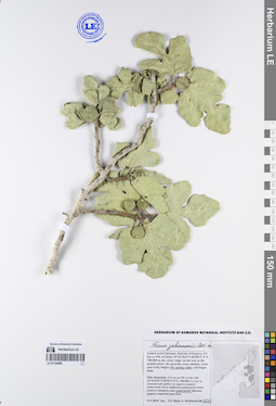
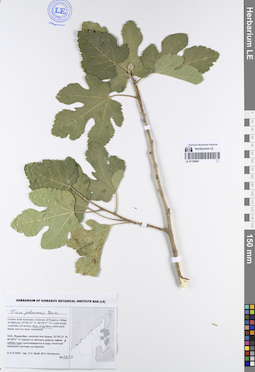
LE 01194986
Ficus johannis Boiss. det. Byalt, Vyacheslav Vyacheslavovich
Collectors: Byalt, Vyacheslav Vyacheslavovich; Korshunov, Vladimir Mikhailovich Field collecting number: 1327. Collection date: 06.04.2018. Administrative regions: AE - United Arab Emirates. Place of collection: Фуджейра, 4-5 км северо-западнее пос. Габ, каменистый хребет, по дороге к вышке мобильной связи: уступы и трещины скал вдоль сухого ручья.Groups of specimens: Образцы общего сектора; Соглашение Минобрнауки №075-15-2021-1056; Бялт В.В.: Флора ФуджейрыOriginal label text: United Arab Emirates. Emirate of Fujaira, 4-5 km to NW of Ghub, 25°34'18.0"N 56°09'27.9"E, 700-800 m alt., stony ridge, on the way to the mobile tower: dry gravelly-stony plateau, rocks and rocky ledges along dry spring valley. – ОАЭ, Фуджейра, 4-5 км на NW от пос. Габ, 25°34'18.0"N 56°09'27.9"E, 700-800 м н. ур. м., каменистый хребет, по дороге к вышке мобильной связи: уступы и трещины скал вдоль сухого ручья, 6 IV 2018, V.V. Byalt, V. Korshunov 1327