View
Add
Copy
Edit
Delete
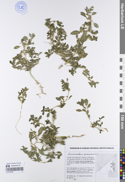
LE 01249272
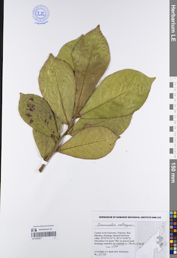
Conocarpus lancifolius Engl. det. Byalt, Vyacheslav Vyacheslavovich
Collectors: Byalt, Vyacheslav Vyacheslavovich; Korshunov, Mikhail Vladimirovich Field collecting number: 3138. Collection date: 23.05.2020. Administrative regions: AE - United Arab Emirates. Place of collection: Fujairah Emirate, Rul Dadhna, Plant Nursery of Abu Abdallah in 1 km North-North-West from ADNOC Petrol Station on E99 Rugaylat road [point 788]: on roadside, near garden wall next to gates of sheikh’s gardens.Groups of specimens: Образцы общего сектора; Соглашение Минобрнауки №075-15-2021-1056; Бялт В.В.: Флора ФуджейрыOriginal label text: United Arab Emirates, Fujairah Emirate, Rul Dadhna, Plant Nursery of Abu Abdallah in 1 km North-North-West from ADNOC Petrol Station on E99 Rugaylat road, 25°32'11.94"N, 56°21'4.36"E, elevation 13 m [point 788]: on roadside, near garden wall next to gates of sheikh’s gardens, 23 V 2020, veg., V.V. Byalt, M.V. Korshunov 3138
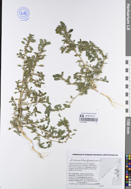
LE 01249271
Terminalia catappa L. det. Byalt, Vyacheslav Vyacheslavovich
Collectors: Byalt, Vyacheslav Vyacheslavovich; Korshunov, Mikhail Vladimirovich Field collecting number: 2209. Collection date: 17.04.2020. Administrative regions: AE - United Arab Emirates. Place of collection: Fujairah Emirate, Rul Dhadna, drainage channel between villas [pont 756]: run wild on roadside in backstreet.Groups of specimens: Образцы общего сектора; Соглашение Минобрнауки №075-15-2021-1056; Бялт В.В.: Флора ФуджейрыOriginal label text: United Arab Emirates. Fujairah Emirate, Rul Dhadna, drainage channel between villas. 25°32'55.32"N, 56°21'16.96"E, elevation 5 m [pont 756]: run wild on roadside in backstreet, 17 IV 2020, veg., V.V. Byalt, M.V. Korshunov 2209
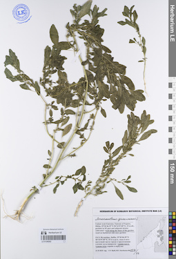
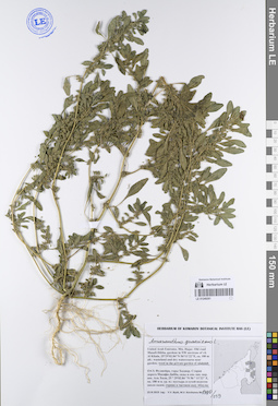
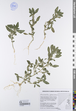
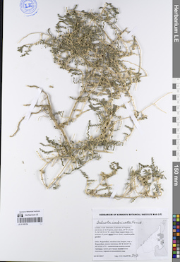
LE 01249270
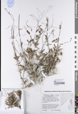
Boerhavia elegans Choisy det. Byalt, Vyacheslav Vyacheslavovich
Additional identifications: Boerhavia rubicunda Steud. det. Byalt, Vyacheslav Vyacheslavovich Collectors: Byalt, Vyacheslav Vyacheslavovich Field collecting number: 502. Collection date: 31.03.2017. Administrative regions: AE - United Arab Emirates. Place of collection: эмират Шаржа, глубокое ущелье на границе с Фуджейрой: каменисто-щебнистый склон.Groups of specimens: Образцы общего сектора; Соглашение Минобрнауки №075-15-2021-1056; Бялт В.В.: Флора ФуджейрыOriginal label text: United Arab Emirates. Emirate of Sharjah, 25°22, 997’ N, 56° 01, 211’ E, 470 m alt., gorge on borders with Fujaira: on stony-gravelly slope.– ОАЭ, Шаржа, 25°22, 997’ N, 56° 01, 211’ E, 470 м выс., глубокое ущелье на границе с Фуджейрой: на каменисто-щебнистом склоне, 31 III 2017, fl., fr., V.V. Byalt 502
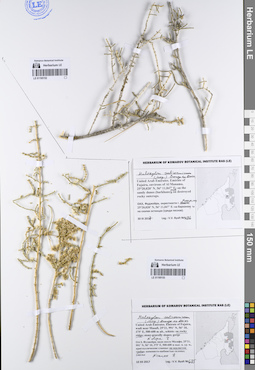
LE 01249269
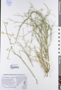
Convolvulus virgatus Boiss. det. Byalt, Vyacheslav Vyacheslavovich
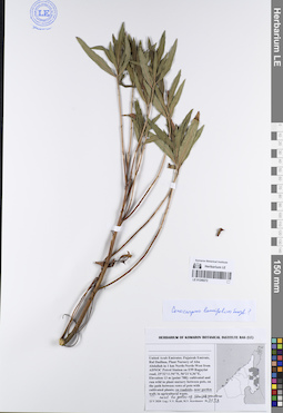
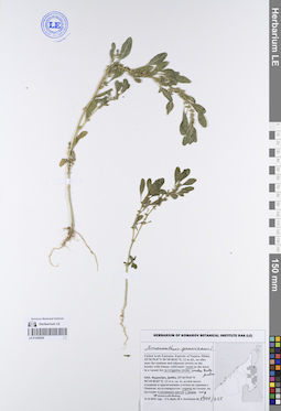
Collectors: Byalt, Vyacheslav Vyacheslavovich; Korshunov, Vladimir Mikhailovich; Melnikov, Denis Germanovich Field collecting number: 46. Collection date: 14.04.2022. Administrative regions: AE - United Arab Emirates. Place of collection: Emirate of Fujaira, environs of Dibba, 3,5 km to SW from Ghub, wadi with waterfall and mineral springs [point 3]: slopes and bottom of wadi.Groups of specimens: Образцы общего сектора; Соглашение Минобрнауки №075-15-2021-1056; Бялт В.В.: Флора ФуджейрыOriginal label text: United Arab Emirates. Emirate of Fujaira, environs of Dibba, 3,5 km to SW from Ghub, 25° 32.823' N, 56° 09.541' E, ca. 220–250 m alt., wadi with waterfall and mineral springs [point 3]: slopes and bottom of wadi, 14 IV 2022, V.V. Byalt, V.M. Korshunov, D.G. Melnikov 46
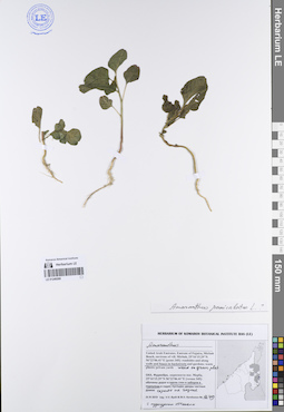
LE 01249268
Amaranthus paniculatus L. det. Byalt, Vyacheslav Vyacheslavovich
Additional identifications: Amaranthus sp. det. Byalt, Vyacheslav Vyacheslavovich Collectors: Byalt, Vyacheslav Vyacheslavovich; Korshunov, Mikhail Vladimirovich Field collecting number: 1649. Collection date: 25.11.2019. Administrative regions: AE - United Arab Emirates. Place of collection: Фуджейра, окрестности пос. Мерба [точка 345]: вдоль стен и заборов в переулке; сорное на газоне.Groups of specimens: Образцы общего сектора; Соглашение Минобрнауки №075-15-2021-1056; Бялт В.В.: Флора ФуджейрыOriginal label text: United Arab Emirates. Emirate of Fujaira, Mirbah Beach, environs of vill. Mirbah, 25°16'15.29"N 56°22'06.41"E [point 345]: along walls and fences in backstreet, weed on grass plot. – ОАЭ, Фуджейра, окресности пос. Мерба, 25°16'15.29"N 56°22'06.41"E [точка 345]: вдоль стен и заборов в переулке; сорное на газоне, с пурпурным оттенком, 25 XI 2019 V.V. Byalt & M.V. Korshunov 1649
LE 01249267
Convolvulus virgatus Boiss. det. Byalt, Vyacheslav Vyacheslavovich
Additional identifications: Convolvulus glomeratus Choiry det. Byalt, Vyacheslav Vyacheslavovich Collectors: Byalt, Vyacheslav Vyacheslavovich; Korshunov, Mikhail Vladimirovich Field collecting number: 1057. Collection date: 27.03.2018. Administrative regions: AE - United Arab Emirates. Place of collection: эмират Фуджейра, шоссе Мазафи – Фуджейра, подножие склона с кустарниками.Groups of specimens: Образцы общего сектора; Соглашение Минобрнауки №075-15-2021-1056; Бялт В.В.: Флора ФуджейрыOriginal label text: United Arab Emirates. Emirate of Fujaira, Masafi – Fujaira road in env. of Fujaira, ca. 25°09'N 56°15'E: foot of slope with bushes.– ОАЭ, эмират Фуджейра, шоссе Мазафи – Фуджейра, ca. 25°09'N 56°15'E, подножие склона с кустарниками, 27 III 2018, V.V. Byalt, M.V. Korshunov 1057
LE 01249266
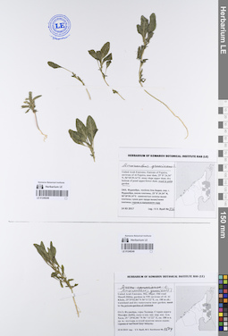
Convolvulus virgatus Boiss. det. Byalt, Vyacheslav Vyacheslavovich
Collectors: Byalt, Vyacheslav Vyacheslavovich Field collecting number: 660. Collection date: 12.12.2017. Administrative regions: AE - United Arab Emirates. Place of collection: Фуджейра, эмират Фуджейра, окрестности пос. Дана, скалистый и каменистый склон на обочине шоссе в сторону пос. Аль Бидия.Groups of specimens: Образцы общего сектора; Соглашение Минобрнауки №075-15-2021-1056; Бялт В.В.: Флора ФуджейрыOriginal label text: (?) United Arab Emirates. Emirate of Fujaira, env. of village Dana, 25°27'35" N, 56°21'8" E: rocky and stony slope on roadside to Al Bidya.– ОАЭ, Фуджейра, эмират Фуджейра, окр. посёлока Дана. 25°27'35" N, 56°21'8" E: скалистый и каменистый слон на обочине шоссе в сторону Аль Бидия, 12 XII 2017, V.V. Byalt 660
LE 01249265
Convolvulus virgatus Boiss. det. Byalt, Vyacheslav Vyacheslavovich
Collectors: Byalt, Vyacheslav Vyacheslavovich; Korshunov, Mikhail Vladimirovich Field collecting number: 738. Collection date: 17.03.2020. Administrative regions: AE - United Arab Emirates. Place of collection: Fujairah Emirate, Al Dibba town, Wam Community. Fujairah National Dairy Farm [point 714]: gravel wasteland.Groups of specimens: Образцы общего сектора; Соглашение Минобрнауки №075-15-2021-1056; Бялт В.В.: Флора ФуджейрыOriginal label text: United Arab Emirates, Fujairah Emirate, Al Dibba town, Wam Community. Fujairah National Dairy Farm. 25°36'2.49"N, 56°14'2.64"E, elevation 25 m. [point 714]: gravel wasteland. 17 III 2020, V.V. Byalt, M.V. Korshunov 738
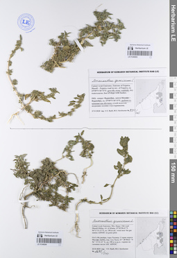
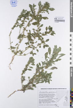
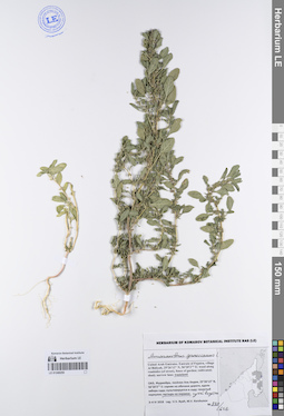
LE 01249263
Amaranthus graecizans L. det. Byalt, Vyacheslav Vyacheslavovich
Collectors: Byalt, Vyacheslav Vyacheslavovich; Korshunov, Mikhail Vladimirovich Field collecting number: 840/105. Collection date: 27.03.2018. Administrative regions: AE - United Arab Emirates. Place of collection: эмират Фуджейра, шоссе Мазафи – Фуджейра, щебнисто-каменистая обочина шоссе.Groups of specimens: Образцы общего сектора; Соглашение Минобрнауки №075-15-2021-1056; Бялт В.В.: Флора ФуджейрыOriginal label text: United Arab Emirates. Emirate of Fujaira, Masafi – Fujaira road in env. of Fujaira, ca. 25°09'N 56°15'E: gravelly-stony roadside of highway.– ОАЭ, эмират Фуджейра, шоссе Мазафи – Фуджейра, ca. 25°09'N 56°15'E, щебнисто-каменистая обочина шоссе, 27 III 2018, fr., V.V. Byalt, M.V. Korshunov 840/105

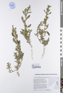
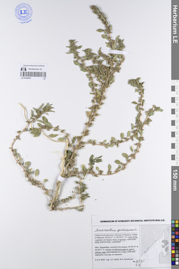
LE 01249264
Amaranthus graecizans L. det. Byalt, Vyacheslav Vyacheslavovich
Collectors: Byalt, Vyacheslav Vyacheslavovich; Korshunov, Mikhail Vladimirovich Field collecting number: 1685/340. Collection date: 23.11.2019. Administrative regions: AE - United Arab Emirates. Place of collection: Фуджейра, горы Хаджар. Старая дорога Масафи-Дибба, окрестности пос. Аль Хала, сорное возле АЗС ADNOC на газонах.Groups of specimens: Образцы общего сектора; Соглашение Минобрнауки №075-15-2021-1056; Бялт В.В.: Флора ФуджейрыOriginal label text: United Arab Emirates. Mts. Hajar. Old road Masafi-Dibba, vil. Al Khala, 25°28'58.62"N 56°11'31.12"E, ca. 190 m alt.: weeds near the gas station ADNOC on grass plots.– ОАЭ, Фуджейра, горы Хаджар. Старая дорога Масафи-Дибба, окр. Аль Хала, 25 ° 28'58.62 "N 56 ° 11'31.12" E, ок. 190 м н.ур.м.: сорняк возле АЗС ADNOC на газоннах, 23 XI 2019, fl., V.V. Byalt, M.V. Korshunov 1685/340
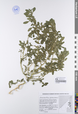
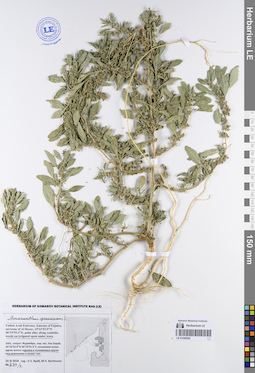
LE 01249262
Amaranthus graecizans L. det. Byalt, Vyacheslav Vyacheslavovich
Collectors: Byalt, Vyacheslav Vyacheslavovich; Korshunov, Mikhail Vladimirovich Field collecting number: 1371/16. Collection date: 21.11.2019. Administrative regions: AE - United Arab Emirates. Place of collection: Фуджейра, г. Дибба, сады в юго-восточной части города и прилегающие улочки: сорное вдоль ограды сада.Groups of specimens: Образцы общего сектора; Соглашение Минобрнауки №075-15-2021-1056; Бялт В.В.: Флора ФуджейрыOriginal label text: United Arab Emirates. Emirate of Fujaira, Dibba, 25°36'46.39"N 56°16'07.85"E, 10 m alt., gardens in SE part and adjacent streets: weed along the fence of the garden. – ОАЭ, Фуджейра, Дибба, 25°36'46.39"N 56°16'07.85"E, 10 м н.ур.м., сады в юго-восточной части города и прилегающие улочки: сорняк вдоль ограды сада, 21 XI 2019, fl., V.V. Byalt, M.V. Korshunov 1371/16
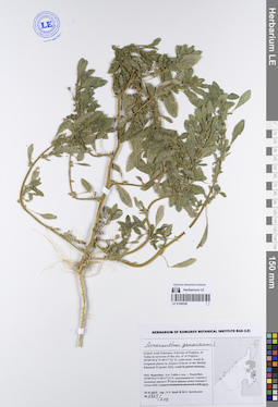
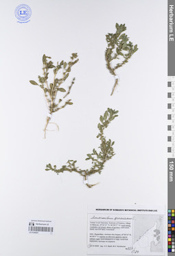
LE 01249261
Amaranthus graecizans L. det. Byalt, Vyacheslav Vyacheslavovich
Collectors: Byalt, Vyacheslav Vyacheslavovich; Korshunov, Mikhail Vladimirovich Field collecting number: 1490/239. Collection date: 23.11.2019. Administrative regions: AE - United Arab Emirates. Place of collection: Фуджейра, горы Хаджар. Старая дорога Масафи-Дибба, сады в северо-западной окрестности пос. Аль Хала, сорное в частном саду Абдулы.Groups of specimens: Образцы общего сектора; Соглашение Минобрнауки №075-15-2021-1056; Бялт В.В.: Флора ФуджейрыOriginal label text: United Arab Emirates. Mts. Hajar. Old road Masafi-Dibba, gardens in NW environs of vil. Al Khala, 25°29'02.84"N 56°11'22"E, ca. 180 m alt.: weed in the private garden of Abdulah. – ОАЭ, Фуджейра, горы Хаджар. Старая дорога Масафи-Дибба, сады в сев.-зап. окр. пос. Аль Хала, 25 ° 29'02.84 "N 56 ° 11'22" E, ок. 180 м н. ур. м.: сорняк в частном саду Абдулы, 23 XI 2019, fl., V.V. Byalt, M.V. Korshunov 1490/239
LE 01249260
Amaranthus graecizans L. det. Byalt, Vyacheslav Vyacheslavovich
Collectors: Byalt, Vyacheslav Vyacheslavovich; Korshunov, Mikhail Vladimirovich Field collecting number: 1859/598. Collection date: 29.11.2019. Administrative regions: AE - United Arab Emirates. Place of collection: Фуджейра, дорога Аль Даид-Мазафи, окрестности пос. Мазафи [точка 358]: сорное в питомнике Салмана.Groups of specimens: Образцы общего сектора; Соглашение Минобрнауки №075-15-2021-1056; Бялт В.В.: Флора ФуджейрыOriginal label text: United Arab Emirates. Emirate of Fujaira, Al Dhaid-Masafi Road, environs of Masafi, 25°17'47.19"N 56°07'28.25"E [point 358]: weed in Salman plant Nursery. – ОАЭ, Фуджейра, дорога Аль Даид-Мазафи, окр. Мазафи, 25°17'47.19"N 56°07'28.25"E [точка 358]: сорняк в питомнике Салмана, 29 XI 2019 V.V. Byalt & M.V. Korshunov 1859/598
LE 01249259
Amaranthus graecizans L. det. Byalt, Vyacheslav Vyacheslavovich
Collectors: Byalt, Vyacheslav Vyacheslavovich; Korshunov, Mikhail Vladimirovich Field collecting number: 1744/426. Collection date: 27.11.2017. Administrative regions: AE - United Arab Emirates. Place of collection: эмират Шаржа, г. Хор-Факкан, сорное среди посадок Azadirachta на обочине шоссе у порта.Groups of specimens: Образцы общего сектора; Соглашение Минобрнауки №075-15-2021-1056; Бялт В.В.: Флора ФуджейрыOriginal label text: United Arab Emirates. Emirate of Sharjah, Khor-Fakkan, 25°21'32.81"N 56°20'38.42"E, 3 m alt.: city park: weed in the plantings of Azadirachta near the port on roadside. – ОАЭ, эмират Шаржа, Хор-Факкан, 25°21'32.81"N 56°20'38.42"E, 3 м н.ур.м.: сорное среди посадок Azadirachta на обочине шоссе у порта, 27 XI 2019, fl., V.V. Byalt, M.V. Korshunov 1746/426
LE 01249258
Amaranthus graecizans L. det. Byalt, Vyacheslav Vyacheslavovich
Collectors: Byalt, Vyacheslav Vyacheslavovich; Korshunov, Mikhail Vladimirovich Field collecting number: 1940/727. Collection date: 30.11.2019. Administrative regions: AE - United Arab Emirates. Place of collection: Фуджейра. Эмират Фуджайра. г. Аль-Фуджайра, восточная приморская часть, свалка на пустыре.Groups of specimens: Образцы общего сектора; Соглашение Минобрнауки №075-15-2021-1056; Бялт В.В.: Флора ФуджейрыOriginal label text: United Arab Emirates. Emirate of Fujarah. Al Fujairah, E seafront part, 25°07'55.41"N 56°21'08.54"E, 4 m alt.: in a landfill in a wasteland. – ОАЭ, Фуджейра. Эмират Фуджара. Аль-Фуджайра, вост. приморская часть, 25°07'55.41"N 56°21'08.54"E, 4 м над ур. м.: на свалке на пустыре, 30 XI 2019, fr., V.V. Byalt, M.V. Korshunov 1940/727
LE 01249257
Amaranthus graecizans L. det. Byalt, Vyacheslav Vyacheslavovich
Collectors: Byalt, Vyacheslav Vyacheslavovich; Korshunov, Mikhail Vladimirovich Field collecting number: 1737/338. Collection date: 25.11.2019. Administrative regions: AE - United Arab Emirates. Place of collection: Фуджейра, пос. Кидфа [point 343]: сорное, обочины дорог и вдоль стен и заборов в переулках.Groups of specimens: Образцы общего сектора; Соглашение Минобрнауки №075-15-2021-1056; Бялт В.В.: Флора ФуджейрыOriginal label text: United Arab Emirates. Emirate of Fujaira, village Qidfa, 25°17'40.91"N 56°21'28.51"E [point 343]: weed roadsides and along walls and fences in backstreets. – ОАЭ, Фуджейра, пос. Кидфа, 25°17'40.91"N 56°21'28.51"E [point 343]: сорное, обочины дорог и вдоль стен и заборов в переулках, 25 XI 2019, fl., V.V. Byalt & M.V. Korshunov 1737/338
LE 01249256
Amaranthus graecizans L. det. Byalt, Vyacheslav Vyacheslavovich
Collectors: Byalt, Vyacheslav Vyacheslavovich; Korshunov, Mikhail Vladimirovich Field collecting number: 1563/309. Collection date: 24.11.2019. Administrative regions: AE - United Arab Emirates. Place of collection: Фуджейра, Аль Тайба в окрестности г. Фуджейра: сорное в поливных кругах в северной части фермы шейха Хамада II.Groups of specimens: Образцы общего сектора; Соглашение Минобрнауки №075-15-2021-1056; Бялт В.В.: Флора ФуджейрыOriginal label text: United Arab Emirates. Emirate of Fujaira, Al Taiba in environs of the city of Al Fujeira, 25°09'29.6"N 56°17'31"E: weed in irrigated places in N part of farm of the Sheikh Khamad II [point 342]. – ОАЭ, Фуджейра, Аль Тайба в окр. г. Фуджейра, 25°09'29.6"N 56°17'31"E: сорняк в поливных кругах в N части фермы шейха Хамада II [точка 342], 24 XI 2019, fl., fr., V.V. Byalt & M.V. Korshunov 1563/309
LE 01249255
Amaranthus graecizans L. det. Byalt, Vyacheslav Vyacheslavovich
Collectors: Byalt, Vyacheslav Vyacheslavovich; Korshunov, Mikhail Vladimirovich Field collecting number: 838/626. Collection date: 04.04.2018. Administrative regions: AE - United Arab Emirates. Place of collection: Фуджейра, пос. Аль Бидия, пустырь на окраине.Groups of specimens: Образцы общего сектора; Соглашение Минобрнауки №075-15-2021-1056; Бялт В.В.: Флора ФуджейрыOriginal label text: United Arab Emirates. Emirate of Fujaira, village Al Bidiyah, 25°26'13" N, 56°20'2"° Е: on wasteland. – ОАЭ, Фуджейра, посёлок Аль Бидия, 25°26'13" N, 56°20'2"° Е: пустырь на окраине, 3–4 IV 2018, fr., V.V. Byalt, M.V. Korshunov 838/626
LE 01249253
Amaranthus graecizans L. det. Byalt, Vyacheslav Vyacheslavovich
Collectors: Byalt, Vyacheslav Vyacheslavovich; Korshunov, Mikhail Vladimirovich Field collecting number: 837/616. Collection date: 04.04.2018. Administrative regions: AE - United Arab Emirates. Place of collection: Фуджейра, пос. Аль Бидия, сорное на обочине дороги, вдоль забора сада.Groups of specimens: Образцы общего сектора; Соглашение Минобрнауки №075-15-2021-1056; Бялт В.В.: Флора ФуджейрыOriginal label text: United Arab Emirates. Emirate of Fujaira, village Al Bidiyah, 25°26'13" N, 56°20'2"° Е: weed along roadsides (of street), fence of garden; cultivated. – ОАЭ, Фуджейра, посёлок Аль Бидия, 25°26'13" N, 56°20'2"° Е: сорняк на обочине дороги, вдоль забора сада, 3–4 IV 2018, fr., V.V. Byalt, M.V. Korshunov 837/589
LE 01249252
Amaranthus graecizans L. det. Byalt, Vyacheslav Vyacheslavovich
Collectors: Byalt, Vyacheslav Vyacheslavovich; Korshunov, Mikhail Vladimirovich Field collecting number: 839/2. Collection date: 25.03.2018. Administrative regions: AE - United Arab Emirates. Place of collection: эмират Фуджейра, окрестности пос. Аль Харай, пальмовая аллея вдоль шоссе: сорное в поливаемых кругах под деревьями и вокруг них.Groups of specimens: Образцы общего сектора; Соглашение Минобрнауки №075-15-2021-1056; Бялт В.В.: Флора ФуджейрыOriginal label text: United Arab Emirates. Emirate of Fujaira, environs of Al Haray, 25°23'53.9"N 56°19'55.3"E, palm alley along roadside: weed on irrigated spots under trees. – ОАЭ, эмират Фуджейра, окр. пос. Аль Харай, 25°23'53.9"N 56°19'55.3"E, пальмовая аллея вдоль шоссе: сорняк в поливаемых кругах под деревьями и вокруг них, 25 III 2018, fr., V.V. Byalt, M.V. Korshunov 839/2
LE 01249251
Amaranthus graecizans L. det. Byalt, Vyacheslav Vyacheslavovich
Collectors: Byalt, Vyacheslav Vyacheslavovich; Korshunov, Mikhail Vladimirovich Field collecting number: 837/589. Collection date: 03.04.2018. Administrative regions: AE - United Arab Emirates. Place of collection: Фуджейра, пос. Аль Бидия, сорное на обочине дороги, вдоль забора сада.Groups of specimens: Образцы общего сектора; Соглашение Минобрнауки №075-15-2021-1056; Бялт В.В.: Флора ФуджейрыOriginal label text: United Arab Emirates. Emirate of Fujaira, village Al Bidiyah, 25°26'13" N, 56°20'2"° Е: weed along roadsides (of street), fence of garden; cultivated. – ОАЭ, Фуджейра, посёлок Аль Бидия, 25°26'13" N, 56°20'2"° Е: сорняк на обочине дороги, вдоль забора сада, 3–4 IV 2018, fr., V.V. Byalt, M.V. Korshunov 837/589
LE 01249250
Amaranthus graecizans L. det. Byalt, Vyacheslav Vyacheslavovich
Collectors: Byalt, Vyacheslav Vyacheslavovich; Korshunov, Mikhail Vladimirovich Field collecting number: 1401/325. Collection date: 21.11.2019. Administrative regions: AE - United Arab Emirates. Place of collection: Фуджейра, г. Дибба, аллея около стадиона и прилегающие улочки на границе с Оманом: сорное в поливных кругах под финиками у дома.Groups of specimens: Образцы общего сектора; Соглашение Минобрнауки №075-15-2021-1056; Бялт В.В.: Флора ФуджейрыOriginal label text: United Arab Emirates. Emirate of Fujaira, Dibba, 25°36'59.8"N 56°18'40.02"E, 12 m alt., an alley near the stadium and adjacent streets on the border with Oman: weed in irrigation circles under date palms. – ОАЭ, Фуджейра, Дибба, 25°36'59.8"N 56°18'40.02"E, 12 м н. ур. м., аллея около стадиона и прилегающие улочки на границе с Оманом: сорное в поливных кругах под финиками у дома, 21 XI 2019, fr., V.V. Byalt, M.V. Korshunov 1401/325
LE 01249248
Amaranthus graecizans L. det. Byalt, Vyacheslav Vyacheslavovich
Collectors: Byalt, Vyacheslav Vyacheslavovich Field collecting number: 836. Collection date: 14.12.2017. Administrative regions: AE - United Arab Emirates. Place of collection: Фуджейра, пос. Аль Бидия, окрестности г. Фуджейра, около плотины, сорное в пальмовом саду.Groups of specimens: Образцы общего сектора; Соглашение Минобрнауки №075-15-2021-1056; Бялт В.В.: Флора ФуджейрыOriginal label text: United Arab Emirates. Emirate of Fujaira, environs of Al Fujeira, near dam, 25° 8' 24.34" N, 56°18'39.14"E: weed in date palm garden.– ОАЭ, Фуджейра, посёлок Аль Бидия, окр. г. Фуджейра, около плотины, 25° 8' 24.34" N, 56°18'39.14"E: сорняк в пальмовом саду, 14 XII 2017, fl., V.V. Byalt 836

LE 01249249
Amaranthus graecizans L. det. Byalt, Vyacheslav Vyacheslavovich
Additional identifications: Aizoon canariense L. det. Byalt, Vyacheslav Vyacheslavovich Collectors: Byalt, Vyacheslav Vyacheslavovich; Korshunov, Mikhail Vladimirovich Field collecting number: 1504. Collection date: 23.11.2019. Administrative regions: AE - United Arab Emirates. Place of collection: Фуджейра, горы Хаджар. Старая дорога Масафи-Дибба, сады в северо-западной окрестности пос. Аль Хала, пустырь и сухой водоток около садов.Groups of specimens: Образцы общего сектора; Соглашение Минобрнауки №075-15-2021-1056; Бялт В.В.: Флора ФуджейрыOriginal label text: United Arab Emirates. Mts. Hajar. Old road Masafi-Dibba, gardens in NW environs of vil. Al Khala, 25°29'02.84"N 56°11'22"E, ca. 180 m alt.: wasteland and dry watercourse near garden. – ОАЭ, Фуджейра, горы Хаджар. Старая дорога Масафи-Дибба, сады в сев.-зап. окр. пос. Аль Хала, 25 ° 29'02.84 "N 56 ° 11'22" E, ок. 180 м н. ур. м.: пустырь и сухой водоток около садов, 23 XI 2019 V.V. Byalt, M.V. Korshunov 1504
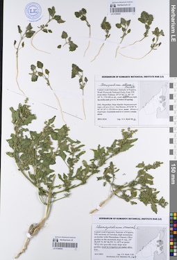
LE 01249246
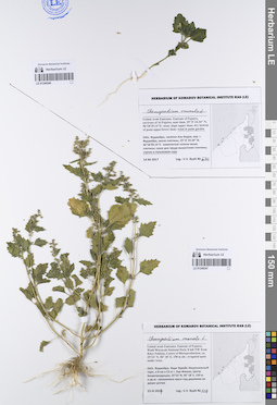
Chenopodium murale L. det. Byalt, Vyacheslav Vyacheslavovich
Collectors: Byalt, Vyacheslav Vyacheslavovich Field collecting number: 676. Collection date: 14.12.2017. Administrative regions: AE - United Arab Emirates. Place of collection: Фуджейра, пос. Аль Бидия, окрестности г. Фуджейра, около плотины, сорное в пальмовом саду.Groups of specimens: Образцы общего сектора; Соглашение Минобрнауки №075-15-2021-1056; Бялт В.В.: Флора ФуджейрыOriginal label text: United Arab Emirates. Emirate of Fujaira, environs of Al Fujeira, near dam, 25° 8' 24.34" N, 56°18'39.14"E: weed in palm garden.– ОАЭ, Фуджейра, посёлок Аль Бидия, окр. г. Фуджейра, около плотины, 25° 8' 24.34" N, 56°18'39.14"E: сорняк в пальмовом саду, 14 XII 2017, V.V. Byalt 676

LE 01249247
Chenopodium murale L. det. Byalt, Vyacheslav Vyacheslavovich
Collectors: Byalt, Vyacheslav Vyacheslavovich Field collecting number: 129. Collection date: 23.03.2017. Administrative regions: AE - United Arab Emirates. Place of collection: Фуджейра, Вади Вурайа Национальный парк, в 8 км северо-западнее г. Хор Факкан, Центр Биорепродукции, орошаемые круги под деревьями во дворе центра.Groups of specimens: Образцы общего сектора; Соглашение Минобрнауки №075-15-2021-1056; Бялт В.В.: Флора ФуджейрыOriginal label text: United Arab Emirates. Emirate of Fujaira, Wadi Wurayah National Park, 8 km NW from Khor Fakkan, Centre of Bioreproduction, ca. 25°23’ N, 56° 18’ E, 150 m alt.: weed in irrigated spots under trees.– ОАЭ, Фуджейра, Вади Вурайа Национальный парк, в 8 км к СЗ от г. Хор Факкан, Центр Биорепродукции, 25°23’ N, 56° 18’ E, 150 м н.ур.м.: орошаемые круги под деревями во дворе центра, 23 III 2017, V.V. Byalt 129

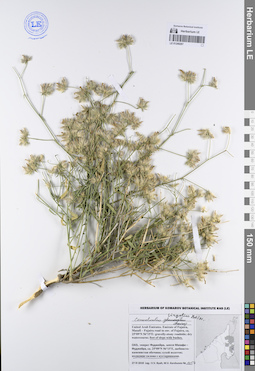
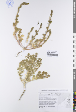
LE 01249244
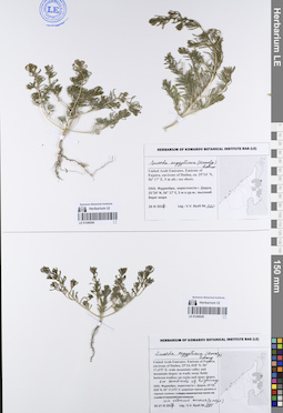
Suaeda aegyptiaca (Hasselq.) Zohary det. Byalt, Vyacheslav Vyacheslavovich
Collectors: Byalt, Vyacheslav Vyacheslavovich Field collecting number: 220. Collection date: 26.03.2017. Administrative regions: AE - United Arab Emirates. Place of collection: Фуджейра, окрестности г. Дадна, высокий берег моря.Groups of specimens: Образцы общего сектора; Соглашение Минобрнауки №075-15-2021-1056; Бялт В.В.: Флора ФуджейрыOriginal label text: United Arab Emirates. Emirate of Fujaira, environs of Dadna, ca. 25°24’ N, 56° 17’ E, 5 m alt.: see shore. – ОАЭ, Фуджейра, окрестности г. Дадна, 25°24’ N, 56° 17’ E, 5 м н.ур.м.: высокий берег моря, 26 III 2017, veg., V.V. Byalt 220
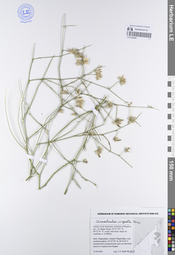
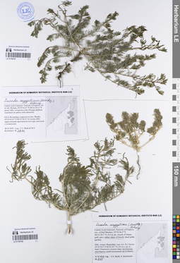
LE 01249245
Suaeda aegyptiaca (Hasselq.) Zohary det. Byalt, Vyacheslav Vyacheslavovich
Collectors: Byalt, Vyacheslav Vyacheslavovich Field collecting number: 290. Collection date: 27.03.2017. Administrative regions: AE - United Arab Emirates. Place of collection: Фуджейра, окрестности г. Дадна, широкая горная долина и горные склоны: на обочине шоссе (у моря).Groups of specimens: Образцы общего сектора; Соглашение Минобрнауки №075-15-2021-1056; Бялт В.В.: Флора ФуджейрыOriginal label text: United Arab Emirates. Emirate of Fujaira, environs of Dadna, 25°24, 018’ N, 56° 17,475’ E: wide mountain valley and mountain slopes: on roadside of highway. – ОАЭ, Фуджейра, окрестности г. Дадна, 25°24, 018’ N, 56° 17,475’ E: широкая горная долина и горные склоны: на обочине шоссе (у моря). 26-27 III 2017, V.V. Byalt 290

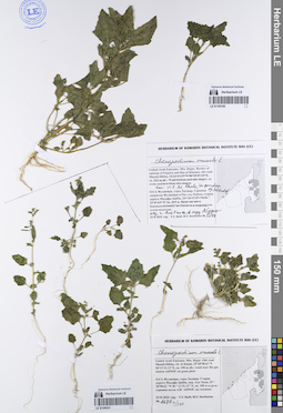
LE 01249242
Chenopodium murale L. det. Byalt, Vyacheslav Vyacheslavovich
Additional identifications: Chenopodium album L. det. Byalt, Vyacheslav Vyacheslavovich Collectors: Byalt, Vyacheslav Vyacheslavovich Field collecting number: 2. Collection date: 20.03.2017. Administrative regions: AE - United Arab Emirates. Place of collection: Фуджейра, Вади Вурайа Национальный парк, в 8 км северо-западнее г. Хор Факкан, около водопада: на гравии.Groups of specimens: Образцы общего сектора; Соглашение Минобрнауки №075-15-2021-1056; Бялт В.В.: Флора ФуджейрыOriginal label text: United Arab Emirates. Emirate of Fujaira, Wadi Wurayah National Park, 8 km NW from Khor Fakkan, 25°23, 366’ N, 56° 18, 356’ E, 165 m alt., near waterfall: in wadi on gravel.– ОАЭ, Фуджейра, Вади Вурайа Национальный парк, в 8 км к СЗ от г. Хор Факкан, 25°23, 366’ N, 56° 18, 356’ E около водопада: на уступах скал; в воде, 20 III 2017, fl., V.V. Byalt 2
LE 01249243
Chenopodium murale L. det. Byalt, Vyacheslav Vyacheslavovich
Collectors: Byalt, Vyacheslav Vyacheslavovich; Korshunov, Vladimir Mikhailovich; Melnikov, Denis Germanovich Field collecting number: 167. Collection date: 18.04.2022. Administrative regions: AE - United Arab Emirates. Place of collection: Emirate of Fujaira, NW environs of Tawaian, high mountains on border with Musandam (Oman), Olive garden on the mountain slope E exp. [point 707c]: weed in irrigation pit under olive tree.Groups of specimens: Образцы общего сектора; Соглашение Минобрнауки №075-15-2021-1056; Бялт В.В.: Флора ФуджейрыOriginal label text: United Arab Emirates. Emirate of Fujaira, NW environs of Tawaian, high mountains on border with Musandam (Oman), Olive garden on the mountain slope E exp., 25° 38.335' N, 56° 06.951' E, 1075 m [point 707c]: weed in irrigation pit under olive tree, 18 IV 2022, fl., fr., V.V. Byalt, V.M. Korshunov, D.G. Melnikov 167

LE 01195160
Chenopodium murale L. det. Byalt, Vyacheslav Vyacheslavovich
Collectors: Byalt, Vyacheslav Vyacheslavovich; Korshunov, Mikhail Vladimirovich Field collecting number: 1544. Collection date: 23.11.2019. Administrative regions: AE - United Arab Emirates. Place of collection: Фуджейра, горы Хаджар. Старая дорога Масафи-Дибба, сады в северо-западной окрестности пос. Аль Хала, сорное в частном саду Абдулы.Groups of specimens: Образцы общего сектора; Соглашение Минобрнауки №075-15-2021-1056; Бялт В.В.: Флора ФуджейрыOriginal label text: United Arab Emirates. Mts. Hajar. Old road Masafi-Dibba, gardens in NW environs of vil. Al Khala, 25°29'02.84"N 56°11'22"E, ca. 180 m alt.: weed in the private garden of Abdulah. – ОАЭ, Фуджейра, горы Хаджар. Старая дорога Масафи-Дибба, сады в сев.-зап. окр. пос. Аль Хала, 25 ° 29'02.84 "N 56 ° 11'22" E, ок. 180 м н. ур. м.: сорняк в частном саду Абдулы, 23 XI 2019 V.V. Byalt, M.V. Korshunov 1544
LE 01249241
Chenopodium murale L. det. Byalt, Vyacheslav Vyacheslavovich
Collectors: Byalt, Vyacheslav Vyacheslavovich; Korshunov, Mikhail Vladimirovich Field collecting number: 1686a/340. Collection date: 23.11.2019. Administrative regions: AE - United Arab Emirates. Place of collection: Фуджейра, горы Хаджар. Старая дорога Масафи-Дибба, окрестности пос. Аль Хала, сорное возле АЗС ADNOC на газонах.Groups of specimens: Образцы общего сектора; Соглашение Минобрнауки №075-15-2021-1056; Бялт В.В.: Флора ФуджейрыOriginal label text: United Arab Emirates. Mts. Hajar. Old road Masafi-Dibba, vil. Al Khala, 25°28'58.62"N 56°11'31.12"E, ca. 190 m alt.: weeds near the gas station ADNOC on grass plots.– ОАЭ, Фуджейра, горы Хаджар. Старая дорога Масафи-Дибба, окр. Аль Хала, 25 ° 28'58.62 "N 56 ° 11'31.12" E, ок. 190 м н.ур.м.: сорняк возле АЗС ADNOC на газонах, 23 XI 2019, fl., V.V. Byalt, M.V. Korshunov 1686a/340
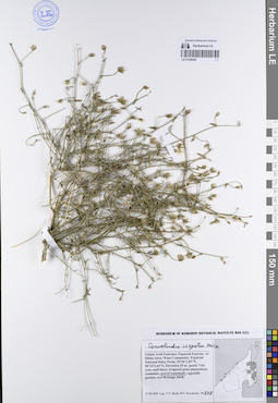
LE 01195159
Suaeda aegyptiaca (Hasselq.) Zohary det. Byalt, Vyacheslav Vyacheslavovich
Collectors: Byalt, Vyacheslav Vyacheslavovich; Korshunov, Vladimir Mikhailovich Field collecting number: 811. Collection date: 31.03.2018. Administrative regions: AE - United Arab Emirates. Place of collection: эмират Фуджейра, окрестности пос. Рул Дадна, берег Оманского залива: пирс, засоленные края берега.Groups of specimens: Образцы общего сектора; Соглашение Минобрнауки №075-15-2021-1056; Бялт В.В.: Флора ФуджейрыOriginal label text: United Arab Emirates. Emirate of Fujaira, env. of Rul Dhadna, 25°32'26.3"N 56°21'35.7"E, 0–5 m alt., beach of Oman gulf: pier; saline edges of beach; daed palm garden. – ОАЭ, эмират Фуджейра, окр. пос. Рул Дадна, 25°32'26.3"N 56°21'35.7"E, 0–5 м н. ур. м., берег Оманского залива: пирс, засоленные края берега, 31 III 2018, veg., fr., V.V. Byalt, V. Korshunov 811
LE 01195157
Suaeda aegyptiaca (Hasselq.) Zohary det. Byalt, Vyacheslav Vyacheslavovich
Collectors: Byalt, Vyacheslav Vyacheslavovich; Korshunov, Mikhail Vladimirovich Field collecting number: 1800. Collection date: 28.11.2019. Administrative regions: AE - United Arab Emirates. Place of collection: Фуджейра, окресности пос. Мерба [точка 349]: зарастающий просописом Prosopis juliflora пустырь (местами с солянками Salsola sp.).Groups of specimens: Образцы общего сектора; Соглашение Минобрнауки №075-15-2021-1056; Бялт В.В.: Флора ФуджейрыOriginal label text: United Arab Emirates. Emirate of Fujaira, env. of vill. Mirbah, 25°15'41.67"N 56°21'29.11"E [point 349]: overgrown with Prosopis juliflora wasteland (in places with saltwarts).– ОАЭ, Фуджейра, окресности пос. Мерба, 25°15'41.67"N 56°21'29.11"E [точка 349]: зарастающий просописом пустырь (местами с солянками), 28 XI 2019, veg., V.V. Byalt & M.V. Korshunov 1800/498

LE 01195158
Suaeda aegyptiaca (Hasselq.) Zohary det. Byalt, Vyacheslav Vyacheslavovich
Collectors: Byalt, Vyacheslav Vyacheslavovich; Korshunov, Vladimir Mikhailovich Field collecting number: 815. Collection date: 31.03.2018. Administrative regions: AE - United Arab Emirates. Place of collection: Фуджейра, окрестности пос. Рул Дадна, берег Оманского залива: засоленные края берега.Groups of specimens: Образцы общего сектора; Соглашение Минобрнауки №075-15-2021-1056; Бялт В.В.: Флора ФуджейрыOriginal label text: United Arab Emirates. Emirate of Fujaira, env. of Rul Dhadna, 25°32'26.3"N 56°21'35.7"E, 0–5 m alt., beach of Oman gulf: saline edges of beach. – ОАЭ, эмират Фуджейра, окр. пос. Рул Дадна, 25°32'26.3"N 56°21'35.7"E, 0–5 м н. ур. м., берег Оманского залива: засоленные края берега, 31 III 2018, veg., fr., V.V. Byalt, V. Korshunov 815
LE 01195156
Amaranthus graecizans L. det. Byalt, Vyacheslav Vyacheslavovich
Collectors: Byalt, Vyacheslav Vyacheslavovich; Korshunov, Mikhail Vladimirovich Field collecting number: 1417/115. Collection date: 22.11.2019. Administrative regions: AE - United Arab Emirates. Place of collection: Фуджейра, пос. Авала, двор форта Ахвала.Groups of specimens: Образцы общего сектора; Соглашение Минобрнауки №075-15-2021-1056; Бялт В.В.: Флора ФуджейрыOriginal label text: United Arab Emirates. Emirate of Fujaira, vil. Ahwala, 24°54'31.11"N 56°18'11.596"E, ca. 80 m alt.: in the yard of Ahwala Fort; roadsides in village. – ОАЭ, Фуджейра, пос. Авала, 24 ° 54'31,11 "N 56 ° 18'11,596" E, ок. 80 м н.ур.м.: во дворе форта Ахвала, 22 XI 2019, fl., V.V. Byalt, M.V. Korshunov 1417/115
LE 01195155
Amaranthus graecizans L. det. Byalt, Vyacheslav Vyacheslavovich
Collectors: Byalt, Vyacheslav Vyacheslavovich; Korshunov, Mikhail Vladimirovich Field collecting number: 1809/475. Collection date: 27.11.2019. Administrative regions: AE - United Arab Emirates. Place of collection: Фуджейра, морская набережная г. Фуджейра [точка 347]: сорное в поливных кругах между полосами шоссе в середине набережной у насосной станции.Groups of specimens: Образцы общего сектора; Соглашение Минобрнауки №075-15-2021-1056; Бялт В.В.: Флора ФуджейрыOriginal label text: United Arab Emirates. Emirate of Fujaira, seafront of the city of Al Fujeira, 25°07'18.09"N 56°21'22.92"E [point 347]: weed in irrigated circles between highway lanes at the middle of the seefront. – ОАЭ, Фуджейра, морская набережная г. Фуджейра, 25°06'38.35"N 56°21'27.04"E [точка 347]: сорняк в поливных кругах между полосами шоссе в середине набережной у насосной станции, 27 XI 2019 V.V. Byalt & M.V. Korshunov 1809
LE 01195154
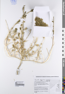
Salsola imbricata Forssk. det. Byalt, Vyacheslav Vyacheslavovich
Collectors: Byalt, Vyacheslav Vyacheslavovich Field collecting number: 347. Collection date: 14.12.2017. Administrative regions: AE - United Arab Emirates. Place of collection: Фуджейра, пос. Аль Бидия, окрестности г. Фуджейра, около плотины, сухое дно пруда ниже плотины.Groups of specimens: Образцы общего сектора; Соглашение Минобрнауки №075-15-2021-1056; Бялт В.В.: Флора ФуджейрыOriginal label text: United Arab Emirates. Emirate of Fujaira, environs of Al Fujeira, near dam, 25° 8' 24.34" N, 56°18'39.14"E: stony slope upper dam; dry bottom of pond upper/lower dam; weed in palm garden.– ОАЭ, Фуджейра, посёлок Аль Бидия, окр. г. Фуджейра, около плотины, 25° 8' 24.34" N, 56°18'39.14"E: сухое дно пруда ниже плотины, 14 XII 2017, veg., V.V. Byalt 347

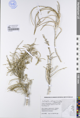
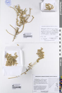
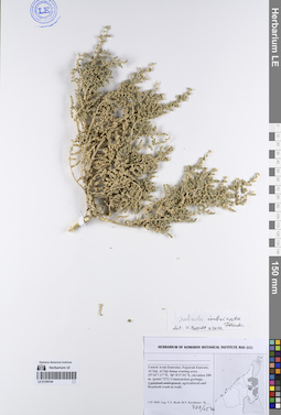
LE 01195152
Haloxylon salicornicum (Moq.) Bunge ex Boiss. det. Byalt, Vyacheslav Vyacheslavovich
Collectors: Byalt, Vyacheslav Vyacheslavovich Field collecting number: 486. Collection date: 30.03.2017. Administrative regions: AE - United Arab Emirates. Place of collection: Фуджейра, окрестности г. Манама, скалы-останцы (среди песков) и на барханах.Groups of specimens: Образцы общего сектора; Соглашение Минобрнауки №075-15-2021-1056; Бялт В.В.: Флора ФуджейрыOriginal label text: United Arab Emirates. Emirate of Fujaira, environs of Al Manama, 25°20,020’ N, 56° 11,847’ E: on destroyed rocky outcrops. – ОАЭ, Фуджейра, окрестности г. Манама, 25°20,020’ N, 56° 11,847’ E: на скалах останцах (среди песков) и на барханах, 30 III 2017, V.V. Byalt 486
LE 01195153
Haloxylon salicornicum (Moq.) Bunge ex Boiss. det. Byalt, Vyacheslav Vyacheslavovich
Collectors: Byalt, Vyacheslav Vyacheslavovich Field collecting number: 675. Collection date: 10.12.2017. Administrative regions: AE - United Arab Emirates. Place of collection: Фуджейра, вади около пос. Мазафи, скалистый гребень, у тропы на гребне.Groups of specimens: Образцы общего сектора; Соглашение Минобрнауки №075-15-2021-1056; Бялт В.В.: Флора ФуджейрыOriginal label text: United Arab Emirates. Emirate of Fujaira, wadi near Musafi, 25°21, 991’ N, 56° 10, 375’ E, 500–600 m alt.: on rocky ridge, path side.– ОАЭ, Фуджейра, вади около Мазафи, 25°21, 991’ N, 56° 10, 375’ E, 500–600 м выс. н. ур. м.: на скалистом гребне, у тропы на гребне, 10 XII 2017, V.V. Byalt 675
LE 01195151
Haloxylon salicornicum (Moq.) Bunge ex Boiss. det. Byalt, Vyacheslav Vyacheslavovich
Collectors: Byalt, Vyacheslav Vyacheslavovich Field collecting number: 181. Collection date: 24.03.2017. Administrative regions: AE - United Arab Emirates. Place of collection: Шаржа, окрестности г. Шаржа: барханные пески в 2–3 км юго-восточнее Шаржинского зоопарка.Groups of specimens: Образцы общего сектора; Соглашение Минобрнауки №075-15-2021-1056; Бялт В.В.: Флора ФуджейрыOriginal label text:United Arab Emirates. Emirate of Sharja, environs of Sharja, sands in 2–3 km to SE from Sharja zoo.– ОАЭ, Шаржа, окрестности г. Шаржа: барханные пески в 2–3 км к ЮВ от Шаржинского зоопарка, 24 III 2017, V.V. Byalt 181
Landscape in location of collection: барханные пескиSubstrate in collecting location: песокCoordinates (geographic position): 25° 16′ 6.37″ N, 55° 42′ 36.82″ E ±100 mRecord creation: 2023-08-11, Larisa Orlova, PhotoScan D2.Citation: Specimen LE 01195151 // Virtual herbarium of Komarov Botanical Institute RAS — http://re.herbariumle.ru/01195151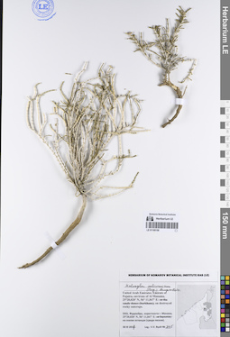
LE 01195150
Haloxylon salicornicum (Moq.) Bunge ex Boiss. det. Byalt, Vyacheslav Vyacheslavovich
Collectors: Byalt, Vyacheslav Vyacheslavovich Field collecting number: 345. Collection date: 30.03.2017. Administrative regions: AE - United Arab Emirates. Place of collection: Фуджейра, окрестности г. Манама, скалы-останцы (среди песков).Groups of specimens: Образцы общего сектора; Соглашение Минобрнауки №075-15-2021-1056; Бялт В.В.: Флора ФуджейрыOriginal label text:United Arab Emirates. Emirate of Fujaira, environs of Al Manama, 25°20.020' N, 56°11.847' E: on destroyed rocky outcrops.- ОАЭ. Фуджейра, окрестности г. Манама, 25°20.020' N, 56°11.847' E: на скалах останцах (среди песков). 30 III 2017. Leg.: V.V. Byalt 345
Landscape in location of collection: скалы-останцы (среди песков)Coordinates (geographic position): 25° 20′ 1.2″ N, 56° 11′ 50.82″ E ±100 mRecord creation: 2023-08-11, Larisa Orlova, PhotoScan D2.Citation: Specimen LE 01195150 // Virtual herbarium of Komarov Botanical Institute RAS — http://re.herbariumle.ru/01195150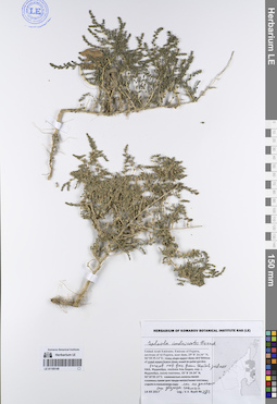
LE 01195149
Salsola imbricata Forssk. det. Byalt, Vyacheslav Vyacheslavovich
Collectors: Byalt, Vyacheslav Vyacheslavovich Field collecting number: 292. Collection date: 14.12.2017. Administrative regions: AE - United Arab Emirates. Place of collection: Фуджейра, пос. Аль Бидия, окрестности г. Фуджейра, реликтовый лес около дворца шейха, редкий лес и кустарники.Groups of specimens: Образцы общего сектора; Соглашение Минобрнауки №075-15-2021-1056; Бялт В.В.: Флора ФуджейрыOriginal label text: United Arab Emirates. Emirate of Fujaira, environs of Al Fujeira, relict forest near Sheikh palace, 25° 8' 24.34" N, 56°18'39.14"E: woodland and bushes; dry watercourse with dense bushes.– ОАЭ, Фуджейра, посёлок Аль Бидия, окр. г. Фуджейра, реликтоый лес около дворца шейха, 25° 8' 24.34" N, 56°18'39.14"E: редкий лес и кустарники, 14 XII 2017, fl., V.V. Byalt 292
LE 01195148
Suaeda aegyptiaca (Hasselq.) Zohary det. Byalt, Vyacheslav Vyacheslavovich
Collectors: Byalt, Vyacheslav Vyacheslavovich Field collecting number: s.n. Collection date: 12.12.2017. Administrative regions: AE - United Arab Emirates. Place of collection: эмират Фуджейра, окрестности пос. Аль Бидия, водосток возле форта Бидия, мертвые пальмовые сады на засоленных почвах после урагана.Groups of specimens: Образцы общего сектора; Соглашение Минобрнауки №075-15-2021-1056; Бялт В.В.: Флора ФуджейрыOriginal label text: United Arab Emirates. Emirate of Fujaira, env. of village Al Bidya, beach near Fort Bidya, 25°26'7" N, 56°21'23"E: daed palm gardens on salted soil after storm.– ОАЭ, Фуджейра, эмират Фуджейра, окр. посёлока Аль Бидия, водосток возле форта Бидия. 25°26'7" N, 56°21'23"E: мертвые пальмовые сады на засоленных почвах после урагана, 12 XII 2017, fr., V.V. Byalt s.n.

LE 01195146
Haloxylon salicornicum (Moq.) Bunge ex Boiss. det. Byalt, Vyacheslav Vyacheslavovich
Collectors: Abramov, Aleksei Vladimirovitch Field collecting number: 676. Collection date: 15.12.2018. Administrative regions: AE - United Arab Emirates. Place of collection: Emirate of Fujaira, Wadi Wurayah National Park, environs of biological station, stony and gravel slopes.Groups of specimens: Образцы общего сектора; Соглашение Минобрнауки №075-15-2021-1056; Бялт В.В.: Флора ФуджейрыOriginal label text: United Arab Emirates. Emirate of Fujaira, Wadi Wurayah National Park, environs of biological station, stony and gravel slopes, 15 XII 2017, A. Abramov 676 bis
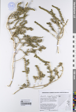
LE 01195147
Haloxylon salicornicum (Moq.) Bunge ex Boiss. det. Byalt, Vyacheslav Vyacheslavovich
Collectors: Byalt, Vyacheslav Vyacheslavovich; Korshunov, Mikhail Vladimirovich Field collecting number: 677. Collection date: 14.12.2017. Administrative regions: AE - United Arab Emirates. Place of collection: Фуджейра, пос. Аль Бидия, окрестности г. Фуджейра, около плотины, каменистые склоны выше плотины.Groups of specimens: Образцы общего сектора; Соглашение Минобрнауки №075-15-2021-1056; Бялт В.В.: Флора ФуджейрыOriginal label text: United Arab Emirates. Emirate of Fujaira, environs of Al Fujeira, near dam, 25° 8' 24.34" N, 56°18'39.14"E: stony slope upper dam.– ОАЭ, Фуджейра, посёлок Аль Бидия, окр. г. Фуджейра, около плотины, 25° 8' 24.34" N, 56°18'39.14"E: каменистые склоны выше плотины, 14 XII 2017, fr., V.V. Byalt, M.V. Korshunov 677
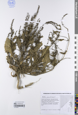
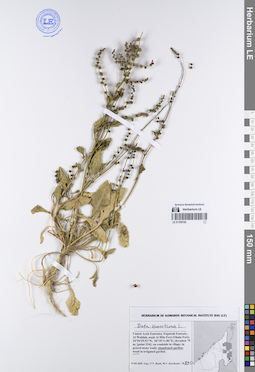
LE 01195145
Beta maritima L. det. Byalt, Vyacheslav Vyacheslavovich
Collectors: Byalt, Vyacheslav Vyacheslavovich; Korshunov, Mikhail Vladimirovich Field collecting number: 961. Collection date: 22.03.2020. Administrative regions: AE - United Arab Emirates. Place of collection: Sharjah Emirate, Khor-Fakkan, shady garden between Khor-Fakkan Port and Al Rabi Tower: on roadside, near garden fence.Groups of specimens: Образцы общего сектора; Соглашение Минобрнауки №075-15-2021-1056; Бялт В.В.: Флора ФуджейрыOriginal label text: United Arab Emirates, Sharjah Emirate, Khor-Fakkan, shady garden between Khor-Fakkan Port and Al Rabi Tower. 25°20'40.63"N, 56°21'34.91"E, elevation 6 m: on roadside, near garden fence, 22 III 2020, fl., fr., V.V. Byalt, M.V. Korshunov 961
LE 01195144
Salsola imbricata Forssk. det. Byalt, Vyacheslav Vyacheslavovich
Collectors: Byalt, Vyacheslav Vyacheslavovich; Korshunov, Mikhail Vladimirovich Field collecting number: 727/1576. Collection date: 01.04.2020. Administrative regions: AE - United Arab Emirates. Place of collection: Fujairah Emirate, Al Siji, Al Siji dump wasting area [point 727]: between construction garbage, agricultural and household trash in wadi.Groups of specimens: Образцы общего сектора; Соглашение Минобрнауки №075-15-2021-1056; Бялт В.В.: Флора ФуджейрыOriginal label text: United Arab Emirates, Fujairah Emirate, Al Siji, Al Siji dump wasting area. 25°16'7.17"N, 56° 0'37.91"E, elevation 200 m. [point 727]: between construction garbage, agricultural and houshold trash in wadi, 1 IV 2020, veg., V.V. Byalt, M.V. Korshunov 1576
LE 01195143
Beta maritima L. det. Byalt, Vyacheslav Vyacheslavovich
Collectors: Byalt, Vyacheslav Vyacheslavovich; Korshunov, Mikhail Vladimirovich Field collecting number: 830. Collection date: 19.03.2020. Administrative regions: AE - United Arab Emirates. Place of collection: Fujairah Emirate, Al Wahlah, wadi Al Hilo Fort (Ohala Fort) [point 334]: in abandoned garden.Groups of specimens: Образцы общего сектора; Соглашение Минобрнауки №075-15-2021-1056; Бялт В.В.: Флора ФуджейрыOriginal label text: United Arab Emirates, Fujairah Emirate, Al Wahlah, wadi Al Hilo Fort (Ohala Fort). 24°54'29.51"N, 56°18'11.86"E, elevation 75 m. [point 334]: in abandoned garden, 19 III 2020, fl., fr., V.V. Byalt, M.V. Korshunov 830
LE 01195142
Suaeda aegyptiaca (Hasselq.) Zohary det. Byalt, Vyacheslav Vyacheslavovich
Collectors: Byalt, Vyacheslav Vyacheslavovich; Korshunov, Vladimir Mikhailovich Field collecting number: 216. Collection date: 31.03.2018. Administrative regions: AE - United Arab Emirates. Place of collection: эмират Фуджейра, окрестности пос. Рул Дадна, берег Оманского залива: засоленные края берега.Groups of specimens: Образцы общего сектора; Соглашение Минобрнауки №075-15-2021-1056; Бялт В.В.: Флора ФуджейрыOriginal label text: United Arab Emirates. Emirate of Fujaira, env. of Rul Dhadna, 25°32'26.3"N 56°21'35.7"E, 0–5 m alt., beach of Oman gulf: saline edges of beach. – ОАЭ, эмират Фуджейра, окр. пос. Рул Дадна, 25°32'26.3"N 56°21'35.7"E, 0–5 м н. ур. м., берег Оманского залива: засоленные края берега, 31 III 2018, V.V. Byalt, V. Korshunov 216