View
Add
Copy
Edit
Delete
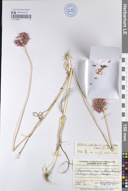
LE 01106414
Allium scorodoprasum ssp. rotundum (L.) Stearn det. Busch
Collectors: Busch Field collecting number: TAX 245/91. Collection date: 24.06.991. Administrative regions: RO - Romania. Groups of specimens: Образцы сектора Центральной и Восточной Азии; Соглашение Минобрнауки №075-15-2021-1056Original label text:Bot. Gart. Bukarest
Record creation: 2023-08-15, Artyom Borodushkin, PhotoScan D2. Part 1.Citation: Specimen LE 01106414 // Virtual herbarium of Komarov Botanical Institute RAS — http://re.herbariumle.ru/01106414Bluetenfarbe dunkelrot
(Ботанический Сад Бухареста
Окраска венчика темно-красная)
LE 01108069
Allium schoenoprasum L. det. Melnikov, Denis Germanovich
Collectors: Melnikov, Denis Germanovich; Kuropatkin, Vladislav Valerievich; Lalenko Il'ya Sergeevich Field collecting number: 125. Collection date: 01.08.2018. Administrative regions: RU - Komi - Inta (gorodskoj okrug). Groups of specimens: Образцы сектора Восточной Европы; Соглашение Минобрнауки №075-15-2021-1056Original label text:Россия, Республика Коми, городской округ Инта, 5,3 километра к северо-востоку от турбазы "Желанное" по дороге. Щебнистая (порода типа сланца) обочина с канавой.
Coordinates (geographic position): 65° 28′ 17.85″ N, 60° 28′ 48.28″ E 235 m a.s.l.Record creation: 2023-08-15, Artyom Borodushkin, PhotoScan D2. Part 2.Citation: Specimen LE 01108069 // Virtual herbarium of Komarov Botanical Institute RAS — http://re.herbariumle.ru/01108069GPS: 65.471625, 60.480077, h=235 м н.у.м.
LE 01106413
Allium sordidiflorum Vved. det. Busch
Collectors: Fritsch, Reinhard Michael Field collecting number: TAX 2538/91. Collection date: 24.06.1991. Administrative regions: TJ - Tajikistan. Groups of specimens: Образцы сектора Центральной и Восточной Азии; Соглашение Минобрнауки №075-15-2021-1056Original label text:Mittelasien 1988, R. Fritsch
Record creation: 2023-08-15, Artyom Borodushkin, PhotoScan D2. Part 1.Citation: Specimen LE 01106413 // Virtual herbarium of Komarov Botanical Institute RAS — http://re.herbariumle.ru/01106413T 329 Tadzhikistan Joli-Tun-Pass,
Kugitek-Gebirge suedoestlich Chovaling
(Средняя Азия 1988, Р. Фрич
Т 329 Таджикистан Йоли-Тун-Пасс
Кугитек-Гебирге сюдёстлих Ховалинг)
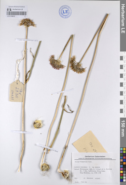
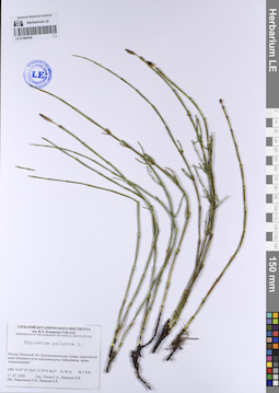
LE 01101906
Equisetum palustre L. det. Lavrinenko O.V., Ivanova, K. V. at 07.2020
Collectors: Tyusov, Grigorii Anatol'evich; Ivanova, K. V. Field collecting number: 18. Collection date: 22.07.2020. Administrative regions: RU - Nenetskiy Avtonomnyy Okrug - Zapolyarny Rayon. Groups of specimens: Образцы сектора Восточной Европы; Соглашение Минобрнауки №075-15-2021-1056; Флора Урала и прилегающих территорий (проект)Original label text:Россия, Ненецкой АО, Большеземельская тундра, окрестности реки Шапкина в р-не впадения ручья Лабадяввож, ивняк разнотравный
GPS: N 67°32'13,7"; Е 55°6'27,3" h= 97 м н.у.м. описание 18
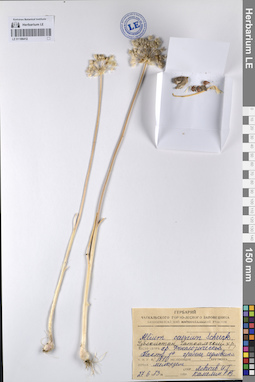
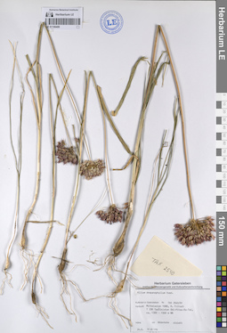
LE 01106412
Allium caesium Schrenk det. Kamelin, Rudolph Vladimirovich
Collectors: Levichev, Igor Germanovich Field collecting number: Нет. Collection date: 27.06.1973. Administrative regions: UZ - Uzbekistan. Groups of specimens: Образцы сектора Центральной и Восточной Азии; Соглашение Минобрнауки №075-15-2021-1056Original label text:Узбекистан, Чаткальский хребет,
Record creation: 2023-08-15, Artyom Borodushkin, PhotoScan D2. Part 1.Citation: Specimen LE 01106412 // Virtual herbarium of Komarov Botanical Institute RAS — http://re.herbariumle.ru/01106412место сбора хребет Фенасогический Тахта 1 гребень седловина
высота над уровнем моря 1910 метров
почва мелкозем
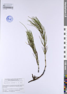
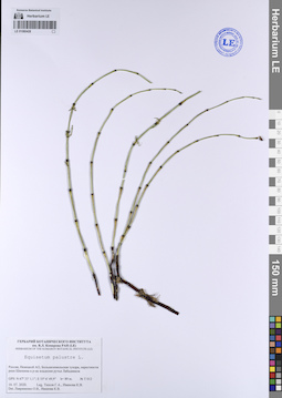
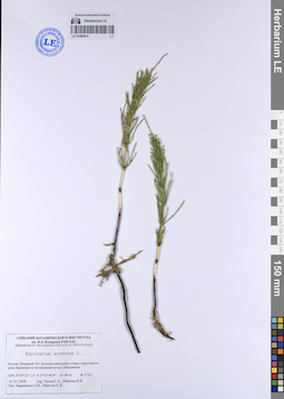
LE 01101898
Equisetum arvense L. ⟮s. str.⟯ det. Lavrinenko O.V., Ivanova, K. V. at 07.2020
Collectors: Tyusov, Grigorii Anatol'evich; Ivanova, K. V. Field collecting number: 18. Collection date: 22.07.2020. Administrative regions: RU - Nenetskiy Avtonomnyy Okrug - Zapolyarny Rayon. Groups of specimens: Образцы сектора Восточной Европы; Соглашение Минобрнауки №075-15-2021-1056; Флора Урала и прилегающих территорий (проект)Original label text:Россия, Ненецкой АО, Большеземельская тундра, окрестности реки Шапкина в р-не впадения ручья Лабадяввож, ивняк разнотравный
GPS: N 67°32'13,7"; Е 55°6'27,3" h= 97 м н.у.м. описание 018
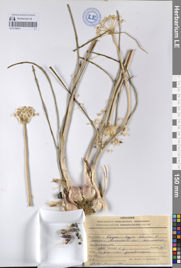
LE 01106411
Collectors: Levichev, Igor Germanovich; Krassovskaja, Lyudmila Stepanovna Field collecting number: Нет. Collection date: 27.06.1980. Administrative regions: UZ - Uzbekistan. Groups of specimens: Образцы сектора Центральной и Восточной Азии; Соглашение Минобрнауки №075-15-2021-1056Original label text: Record creation: 2023-08-15, Artyom Borodushkin, PhotoScan D2. Part 1.Citation: Specimen LE 01106411 // Virtual herbarium of Komarov Botanical Institute RAS — http://re.herbariumle.ru/01106411
гора Кызыл-Кура, склон в бассейн Аксаката-сая, на месте снежника
высота над уровнем моря 2800 метров экспозиция северо-западная крутизна 10°
почва торфянистая унавожена
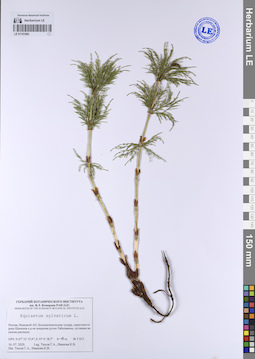
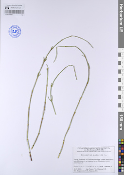
LE 01101885
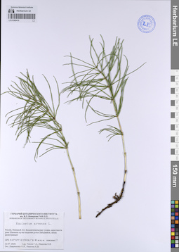
Equisetum sylvaticum L. det. Tyusov, Grigorii Anatol'evich, Ivanova, K. V. at 16.07.2020
Collectors: Tyusov, Grigorii Anatol'evich; Ivanova, K. V. Field collecting number: T 013. Collection date: 16.07.2020. Administrative regions: RU - Nenetskiy Avtonomnyy Okrug - Zapolyarny Rayon. Groups of specimens: Образцы сектора Восточной Европы; Соглашение Минобрнауки №075-15-2021-1056; Флора Урала и прилегающих территорий (проект)Original label text:Россия, Ненецкой АО, Большеземельская тундра, окрестности реки Шапкина в р-не впадения ручья Лабадяввож, луговина на склоне распадка
GPS: N 67° 32' 55,9"; Е 55° 6' 38,7" h= 90 m. № Т 013
LE 01106410
Allium hissaricum Vved. det. Busch
Collectors: Fritsch, Reinhard Michael; Pistrick, Klaus Field collecting number: TAX 2535/91. Collection date: 24.06.1991. Administrative regions: TJ - Tajikistan. Groups of specimens: Образцы сектора Центральной и Восточной Азии; Соглашение Минобрнауки №075-15-2021-1056Original label text:Mittelasien 1990, R. Fritsch et K. Pistrick
Record creation: 2023-08-15, Artyom Borodushkin, PhotoScan D2. Part 1.Citation: Specimen LE 01106410 // Virtual herbarium of Komarov Botanical Institute RAS — http://re.herbariumle.ru/01106410Nr. T 455 Tadzhikistan Aktau-Kamm,
Berg Mundytau, ca. 2180 m NN
(Средняя Азия 1990, Р. Фрич и К. Пистрик
Номер Т 455 Таджикистан Актау-Камм
Гора Мундытау, высота 2180 над уровнем моря)
LE 01080438
Equisetum palustre L. det. Lavrinenko O.V., Ivanova, K. V. at 07.2020
Collectors: Tyusov, Grigorii Anatol'evich; Ivanova, K. V. Field collecting number: T 018. Collection date: 17.07.2020. Administrative regions: RU - Nenetskiy Avtonomnyy Okrug - Zapolyarny Rayon. Groups of specimens: Образцы сектора Восточной Европы; Соглашение Минобрнауки №075-15-2021-1056; Флора Урала и прилегающих территорий (проект)Original label text:Россия, Ненецкой АО, Большеземельская тундра, окрестности реки Шапкина в р-не впадения ручья Лабадяввож, ивняк разнотравный
GPS: N 67° 32' 30,6"; Е 55° 6' 46,6" h= 83 m. T 018
LE 01106409
Allium drepanophyllum Vved. det. Busch
Collectors: Fritsch, Reinhard Michael Field collecting number: TAX 2540/91. Collection date: 24.06.1991. Administrative regions: TJ - Tajikistan. Groups of specimens: Образцы сектора Центральной и Восточной Азии; Соглашение Минобрнауки №075-15-2021-1056Original label text:Mittelasien 1988, R. Fritsch
Record creation: 2023-08-15, Artyom Borodushkin, PhotoScan D2. Part 1.Citation: Specimen LE 01106409 // Virtual herbarium of Komarov Botanical Institute RAS — http://re.herbariumle.ru/01106409T 336 Tadzhikistan Obi-Pitau-Du-Tal,
ca. 1300 - 1500 m NN
Bluetenfarbe violett
(Средняя Азия 1988, Р. Фрич
Т 336 Таджикистан Оби-Питау-Ду-Тал
высота 1300 - 1500 метров над уровнем моря
Окраска венчика фиолетовая)
LE 01080428
Equisetum palustre L. det. Lavrinenko O.V., Ivanova, K. V. at 07.2020
Collectors: Tyusov, Grigorii Anatol'evich; Ivanova, K. V. Field collecting number: Т 012. Collection date: 16.07.2020. Administrative regions: RU - Nenetskiy Avtonomnyy Okrug - Zapolyarny Rayon. Groups of specimens: Образцы сектора Восточной Европы; Соглашение Минобрнауки №075-15-2021-1056; Флора Урала и прилегающих территорий (проект)Original label text:Россия, Ненецкой АО, Большеземельская тундра, окрестности реки Шапкина в р-не впадения ручья Лабадяввож
GPS: N 67° 33' 1,1"; Е 55° 6' 49,9" h= 89 m. № Т 012
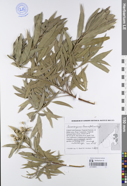
LE 01106408
Allium caesium Schrenk det. Kamelin, Rudolph Vladimirovich
Collectors: Levichev, Igor Germanovich Field collecting number: Нет. Collection date: 16.06.1974. Administrative regions: UZ - Uzbekistan. Groups of specimens: Образцы сектора Центральной и Восточной Азии; Соглашение Минобрнауки №075-15-2021-1056Original label text:венчик бледносиний
Record creation: 2023-08-15, Artyom Borodushkin, PhotoScan D2. Part 1.Citation: Specimen LE 01106408 // Virtual herbarium of Komarov Botanical Institute RAS — http://re.herbariumle.ru/01106408место сбора гора Большая Токали
скалы
экспозиция юго-запад
LE 01080419
Equisetum arvense L. det. Lavrinenko O.V., Ivanova, K. V. at 22.07.2020
Collectors: Tyusov, Grigorii Anatol'evich; Ivanova, K. V. Field collecting number: 17. Collection date: 22.07.2020. Administrative regions: RU - Nenetskiy Avtonomnyy Okrug - Zapolyarny Rayon. Groups of specimens: Образцы сектора Восточной Европы; Соглашение Минобрнауки №075-15-2021-1056; Флора Урала и прилегающих территорий (проект)Original label text:Россия, Ненецкой АО, Большеземельская тундра, окрестности реки Шапкина в р-не впадения ручья Лабадяввож, ивняк разнотравный
GPS: N 67° 32'9"; Е 55°6'26,1" h= 83 м н.у.м. описание 17
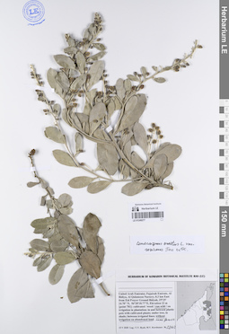
LE 01106407
Allium vavilovii Popov & Vved. det. Kamahina, Galina Leonidovna
Collectors: Kamahina, Galina Leonidovna Field collecting number: Нет. Collection date: 14.05.1994. Administrative regions: TM - Turkmenistan. Groups of specimens: Образцы сектора Центральной и Восточной Азии; Соглашение Минобрнауки №075-15-2021-1056Original label text:Туркмения, Центральный Копетдаг
Record creation: 2023-08-15, Artyom Borodushkin, PhotoScan D2. Part 1.Citation: Specimen LE 01106407 // Virtual herbarium of Komarov Botanical Institute RAS — http://re.herbariumle.ru/01106407горы ...-Эдендаг
LE 01080415
Equisetum arvense L. det. Lavrinenko O.V., Ivanova, K. V. at 16.07.2020
Collectors: Tyusov, Grigorii Anatol'evich; Ivanova, K. V. Field collecting number: Т 012. Collection date: 16.07.2020. Groups of specimens: Образцы сектора Восточной Европы; Соглашение Минобрнауки №075-15-2021-1056; Флора Урала и прилегающих территорий (проект)Original label text:Россия, Ненецкой АО, Большеземельская тундра, окрестности реки Шапкина в р-не впадения ручья Лабадяввож
GPS: N 67° 33'1,1"; Е 55° 6'49,9" h= 89 m. №Т012
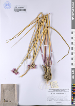
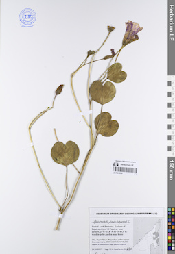
LE 01106406
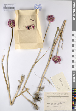
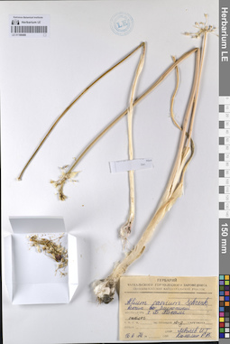
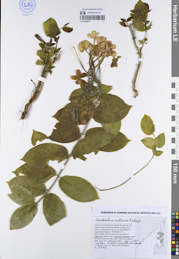
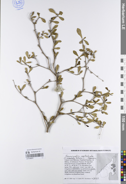
Allium rotundum L. ⟮s. l.⟯ det. Fritsch, Reinhard Michael at 13.09.1996
Collectors: Krassovskaja, Lyudmila Stepanovna; Levichev, Igor Germanovich Collection date: 15.07.1987. Administrative regions: UA - Kirovohrads'ka Oblast'. Groups of specimens: Образцы сектора Центральной и Восточной Азии; Соглашение Минобрнауки №075-15-2021-1056Original label text:Украина, окрестности города Кировограда (к югу), близ реки Ингул
Record creation: 2023-08-15, Artyom Borodushkin, PhotoScan D2. Part 1.. Processing status: label contains unreadable dataCitation: Specimen LE 01106406 // Virtual herbarium of Komarov Botanical Institute RAS — http://re.herbariumle.ru/01106406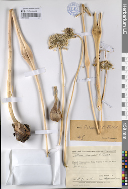
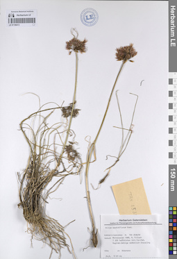
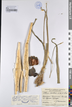
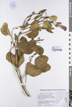
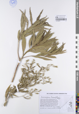
LE 01106405
Allium oschaninii O. Fedtsch. det. Vvedensky, Aleksei Ivanovich at 10.1960
Collectors: Nepli, Georgy Nikolaevich Field collecting number: 25. Collection date: 27.05.1960. Administrative regions: TJ - Tajikistan. Groups of specimens: Образцы сектора Центральной и Восточной Азии; Соглашение Минобрнауки №075-15-2021-1056Original label text:Южный Таджикистан. горы Каратау к западу от моста через реку Кзыл-су.
Record creation: 2023-08-15, Artyom Borodushkin, PhotoScan D2. Part 1.. Processing status: data is not fully enteredCitation: Specimen LE 01106405 // Virtual herbarium of Komarov Botanical Institute RAS — http://re.herbariumle.ru/01106405На скалах.
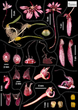
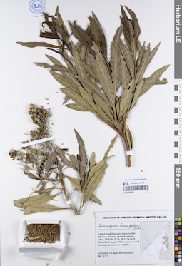
LE 01124300
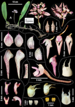
Bulbophyllum longiflorum Thouars det. Truong Ba Vuong, Averyanov, Leonid Vladimirovich at 14.08.2023
Collectors: Truong Ba Vuong; Ngo Quang Dang Field collecting number: BV 1219. Collection date: 2021. Administrative regions: VN - Gia Lai. Original label text:FLORA OF VIETNAM
Comment: Orchidaceae
Bulbophyllum longiflorum Thouars
Gia Lai Province, 2021, Truong Ba Vuong & Ngo Quang Đang, BV 1219 (VNM).
All photos © Truong Ba Vuong
LE 01124299
Bulbophyllum annamense (Garay) Sieder & Kiehn det. Truong Ba Vuong at 01.08.2023
Collectors: Truong Ba Vuong; Ngo Quang Dang Field collecting number: BV 628. Collection date: 2020. Administrative regions: VN - Tinh Lam GJong. Original label text:FLORA OF VIETNAM
Orchidaceae
Bulbophyllum annamense (Garay) Sieder & Kiehn
Lam Dong Province, 2020, Truong Ba Vuong & Ngo Quang Dang, BV 628 (VNM)
All photos © Truong Ba Vuong
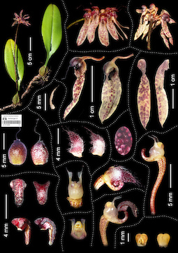
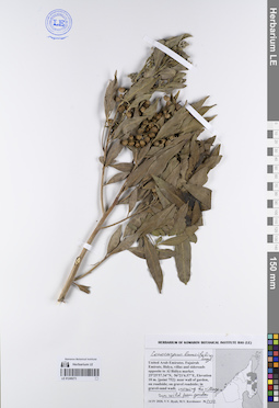
LE 01124297
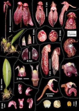
Bulbophylum thangii Vuong, Aver. & R.Amsler
Collectors: Truong Ba Vuong; Nguyen Van Canh; Phan Trong Quyet; Phan Dai Thang Field collecting number: BV 1775. Collection date: 04.07.2023. Administrative regions: VN - Tinh Khanh Hoa. Groups of specimens: L. V. Averyanov specimens; L. V. Averyanov photos; Orchids of Vietnam, Laos and CambodiaOriginal label text:FLORA OF VIETNAM
Orchidaceae
Bulbophylum thangii Vuong, Aver. & R.Amsler
Khanh Hoa Province: Van Ninh District, Van Phu Commune, 4 July 2023, Truong Ba Vuong, Nguyen Van Canh, Phan Trong Quyet & Phan Dai Thang BV 1775 (holotype VNM 00063955!).
All photos © Truong Ba Vuong
LE 01124298
Bulbophyllum fenestratum J.J.Sm. det. Truong Ba Vuong, Averyanov, Leonid Vladimirovich at 14.08.2023
Collectors: Truong Ba Vuong Field collecting number: BV 1737. Collection date: 23.05.2023. Administrative regions: VN - Tinh GJong Nai. Groups of specimens: L. V. Averyanov specimens; L. V. Averyanov photos; Orchids of Vietnam, Laos and CambodiaOriginal label text:FLORA OF VIETNAM
Comment: Orchidaceae
Bulbophyllum fenestratum J.J.Sm.
Dong Nai Province, Tan Phu District, Phu Trung Commune, 23 May 2023, Truong Ba Vuong, BV 1737 (VNM 00063989).
All photos © Truong Ba Vuong
LE 01249300
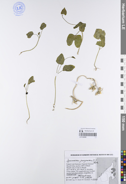
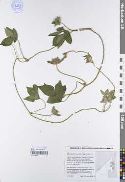
Ipomoea pes-caprae (L.) R.Br. det. Byalt, Vyacheslav Vyacheslavovich
Collectors: Byalt, Vyacheslav Vyacheslavovich Field collecting number: 1061. Collection date: 30.03.2018. Administrative regions: AE - United Arab Emirates. Place of collection: эмират Фуджейра, г. Фуджейра, район города близ аэропорта, сорное в пальмовом саду у жилого дома и культивируется на шпалерах.Groups of specimens: Образцы общего сектора; Соглашение Минобрнауки №075-15-2021-1056; Бялт В.В.: Флора ФуджейрыOriginal label text: United Arab Emirates. Emirate of Fujairah, city of Al Fujeira, near airport, 25°07′11.8″ N, 56°19′49.3″ E, weed in palm garden near home and cultivated liana. — ОАЭ, Эмират Фуджейра, г. Фуджейра, район города близ аэропорта, 25°07′11.8″ N, 56°19′49.3″ E, сорняк в пальмовом саду у жилого дома и культивируется на шпалерах, 30 III 2018, V. V. Byalt 1061
LE 01249299
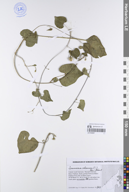
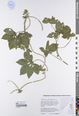
Ipomoea pes-caprae (L.) R.Br. det. Byalt, Vyacheslav Vyacheslavovich
Collectors: Korshunov, Mikhail Vladimirovich Field collecting number: 670. Collection date: 14.12.2017. Administrative regions: AE - United Arab Emirates. Place of collection: Фуджейра, г. Фуджейра, район города близ аэропорта, сорное в пальмовом саду у жилого дома.Groups of specimens: Образцы общего сектора; Соглашение Минобрнауки №075-15-2021-1056; Бялт В.В.: Флора ФуджейрыObject features: fl. pinkOriginal label text: United Arab Emirates. Emirate of Fujaira, city of Al Fujeira, near airport, 25°07′11.8″ N, 56°19′49.3″ E: weed in palm garden near home. — ОАЭ, Фуджейра, г. Фуджейра, район города близ аэропорта, 25°07′11.8″ N, 56°19′49.3″ E: сорняк в пальмовом саду у жилого дома, 14 XII 2017, M. V. Korshunov 670
LE 01249298
Ipomoea purpurea (L.) Roth det. Byalt, Vyacheslav Vyacheslavovich
Collectors: Byalt, Vyacheslav Vyacheslavovich; Korshunov, Mikhail Vladimirovich Field collecting number: 1689. Collection date: 03.04.2020. Administrative regions: AE - United Arab Emirates. Place of collection: Fujairah Emirate, Masafi friday market, E88 Al Dhaid — Masafi road, 5.2 km to Masafi [point 732]: weed in plant market and plant nursery, selfseedings near pots with parent plants.Groups of specimens: Образцы общего сектора; Соглашение Минобрнауки №075-15-2021-1056; Бялт В.В.: Флора ФуджейрыOriginal label text: United Arab Emirates, Fujairah Emirate, Masafi friday market, E88 Al Dhaid — Masafi road, 5.2 km to Masafi. 25°17′28.28″ N, 56° 6′48.62″ E, elevation 370 m. [point 732]: weed in plant market and plant nursery, selfseedings near pots with parient plants, 3 IV 2020, fr., veg., V. V. Byalt, M. V. Korshunov 1689
LE 01249297
Ipomoea obscura (L.) Ker Gawl. det. Byalt, Vyacheslav Vyacheslavovich
Collectors: Byalt, Vyacheslav Vyacheslavovich; Korshunov, Mikhail Vladimirovich Field collecting number: 968. Collection date: 22.03.2020. Administrative regions: AE - United Arab Emirates. Place of collection: Sharjah Emirate, Khor-Fakkan, shady garden between Khor-Fakkan Port and Al Rabi Tower, on roadside, on garden fence.Groups of specimens: Образцы общего сектора; Соглашение Минобрнауки №075-15-2021-1056; Бялт В.В.: Флора ФуджейрыOriginal label text: United Arab Emirates, Sharjah Emirate, Khor-Fakkan, shady garden between Khor-Fakkan Port and Al Rabi Tower. 25°20′40.63″ N, 56°21′34.91″ E, elevation 6 m: on roadside, on garden fence, 22 III 2020, fl., V. V. Byalt, M. V. Korshunov 968
LE 01249296
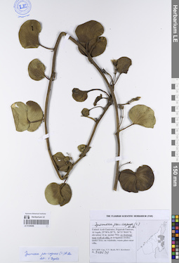
Ipomoea pes-caprae (L.) R.Br. det. Byalt, Vyacheslav Vyacheslavovich
Collectors: Byalt, Vyacheslav Vyacheslavovich; Korshunov, Mikhail Vladimirovich Field collecting number: 3295 (2). Collection date: 26.05.2020. Administrative regions: AE - United Arab Emirates. Place of collection: Fujairah Emirate, Al Aqah [point 792]: on drainage near wall of villa.Groups of specimens: Образцы общего сектора; Соглашение Минобрнауки №075-15-2021-1056; Бялт В.В.: Флора ФуджейрыOriginal label text: United Arab Emirates, Fujairah Emirate, Al Aqah, 25°30′6.28″ N, 56°21′30.01″ E, elevation 14 m [point 792]: on drainage near wall of villa, 26 V 2020, fl., V. V. Byalt, M. V. Korshunov 3295(2)
LE 01249295
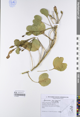
Ipomoea pes-caprae (L.) R.Br. det. Byalt, Vyacheslav Vyacheslavovich
Collectors: Byalt, Vyacheslav Vyacheslavovich; Korshunov, Mikhail Vladimirovich Field collecting number: 1199. Collection date: 26.03.2020. Administrative regions: AE - United Arab Emirates. Place of collection: Fujairah Emirate, Rul Dadhna, environs of vil. Sharm, shore of Oman Gulf, elevation ca. 1 m: on dune.Groups of specimens: Образцы общего сектора; Соглашение Минобрнауки №075-15-2021-1056; Бялт В.В.: Флора ФуджейрыOriginal label text: United Arab Emirates, Fujairah Emirate, Rul Dadhna, env. vil. Sharm, shore of Oman Gulf, ca. 25°31′ N, 56°20′ E, elevation ca. 1 m: on dune, 26 III 2020, fl., fr., V. V. Byalt, M. V. Korshunov 1199
LE 01249294
Ipomoea pes-tigridis L. det. Byalt, Vyacheslav Vyacheslavovich
Collectors: Byalt, Vyacheslav Vyacheslavovich Field collecting number: 671. Collection date: 11.12.2017. Administrative regions: AE - United Arab Emirates. Place of collection: Фуджейра, окрестности г. Аль Фуджейра, пос. Бидия, сад директора национального парка Али возле гор Хаджар, сорное в питомнике.Groups of specimens: Образцы общего сектора; Соглашение Минобрнауки №075-15-2021-1056; Бялт В.В.: Флора ФуджейрыOriginal label text: United Arab Emirates. Emirate of Fujaira, env. of Al Fujaira, private garden and nursery of Dr. Ali near Hajar mountains, 25°26'13'' N, 56°20'2'' Е: weed in nursery, liana.– ОАЭ, Фуджейра, окр. г. Аль Фуджейра, посёлок Бидия, сад директора нац. парка Али возле гор Хаджар, 25°26'13'' N, 56°20'2'' Е: сорняк в питомнике, лиана, 11 XII 2017, V.V. Byalt 671
LE 01249293
Ipomoea pes-tigridis L. det. Byalt, Vyacheslav Vyacheslavovich
Collectors: Byalt, Vyacheslav Vyacheslavovich Field collecting number: 671. Collection date: 11.12.2017. Administrative regions: AE - United Arab Emirates. Place of collection: Фуджейра, окрестности г. Аль Фуджейра, пос. Бидия, сад директора национального парка Али возле гор Хаджар, сорное в питомнике, лиана.Groups of specimens: Образцы общего сектора; Соглашение Минобрнауки №075-15-2021-1056; Бялт В.В.: Флора ФуджейрыLife form: lianaOriginal label text: United Arab Emirates. Emirate of Fujaira, env. of Al Fujaira, private garden and nursery of Dr. Ali near Hajar mountains, 25°26'13'' N, 56°20'2'' Е: weed in nursery, liana.– ОАЭ, Фуджейра, окр. г. Аль Фуджейра, посёлок Бидия, сад директора нац. парка Али возле гор Хаджар, 25°26'13'' N, 56°20'2'' Е: сорняк в питомнике, лиана, 11 XII 2017, V.V. Byalt 671
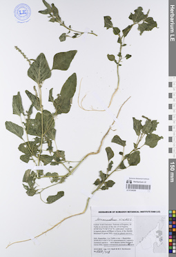
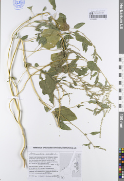
LE 01249292
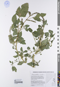
Amaranthus viridis L. det. Byalt, Vyacheslav Vyacheslavovich
Collectors: Byalt, Vyacheslav Vyacheslavovich; Korshunov, Mikhail Vladimirovich Field collecting number: 1812. Collection date: 27.11.2019. Administrative regions: AE - United Arab Emirates. Place of collection: Фуджейра, морская набережная г. Фуджейра [точка 347]: сорное в поливных кругах между полосами шоссе в середине набережной.Groups of specimens: Образцы общего сектора; Соглашение Минобрнауки №075-15-2021-1056; Бялт В.В.: Флора ФуджейрыOriginal label text: United Arab Emirates. Emirate of Fujaira, seafront of the city of Al Fujeira, 25°07'18.09"N 56°21'22.92"E [point 347]: weed in irrigated circles between highway lanes at the middle of the seefront. – ОАЭ, Фуджейра, морская набережная г. Фуджейра, 25°06'38.35"N 56°21'27.04"E [точка 347]: сорняк в поливных кругах между полосами шоссе в середине набережной, 27 XI 2019, fl., V.V. Byalt & M.V. Korshunov 1812
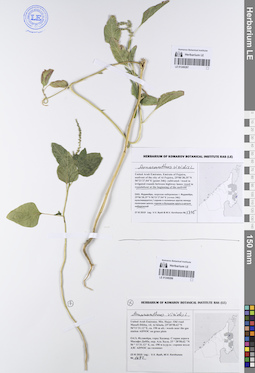
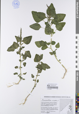
LE 01249290
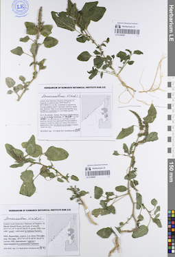
Amaranthus viridis L. det. Byalt, Vyacheslav Vyacheslavovich
Collectors: Byalt, Vyacheslav Vyacheslavovich; Korshunov, Mikhail Vladimirovich Field collecting number: 1948. Collection date: 30.11.2019. Administrative regions: AE - United Arab Emirates. Place of collection: Фуджейра. Эмират Фуджайра. г. Аль-Фуджайра, восточная приморская часть, свалка на пустыре.Groups of specimens: Образцы общего сектора; Соглашение Минобрнауки №075-15-2021-1056; Бялт В.В.: Флора ФуджейрыOriginal label text: United Arab Emirates. Emirate of Fujarah. Al Fujairah, E seafront part, 25°07'55.41"N 56°21'08.54"E, 4 m alt.: in a landfill in a wasteland. – ОАЭ, Фуджейра. Эмират Фуджара. Аль-Фуджайра, вост. приморская часть, 25°07'55.41"N 56°21'08.54"E, 4 м над ур. м.: на свалке на пустыре, 30 XI 2019, fl., fr., V.V. Byalt, M.V. Korshunov 1948

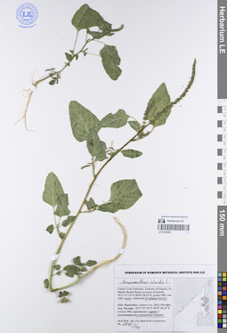
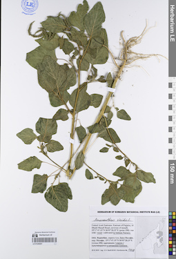
LE 01249291
Amaranthus viridis L. det. Byalt, Vyacheslav Vyacheslavovich
Collectors: Byalt, Vyacheslav Vyacheslavovich; Korshunov, Mikhail Vladimirovich Field collecting number: 1842. Collection date: 29.11.2019. Administrative regions: AE - United Arab Emirates. Place of collection: Фуджейра, дорога Аль Даид-Мазафи, окрестности пос. Мазафи [точка 358]: сорное в питомнике Салмана.Groups of specimens: Образцы общего сектора; Соглашение Минобрнауки №075-15-2021-1056; Бялт В.В.: Флора ФуджейрыOriginal label text: United Arab Emirates. Emirate of Fujaira, Al Dhaid-Masafi Road, environs of Masafi, 25°17'47.19"N 56°07'28.25"E [point 358]: weed in the Salman plant Nursery. – ОАЭ, Фуджейра, дорога Аль Даид-Мазафи, окр. Мазафи, 25°17'47.19"N 56°07'28.25"E [точка 358]: сорняк в питомнике Салмана, 29 XI 2019, fl., V.V. Byalt & M.V. Korshunov 1842
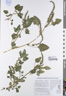
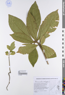
LE 01249289
Amaranthus viridis L. det. Byalt, Vyacheslav Vyacheslavovich
Collectors: Byalt, Vyacheslav Vyacheslavovich; Korshunov, Mikhail Vladimirovich Field collecting number: 1569/301. Collection date: 24.11.2019. Administrative regions: AE - United Arab Emirates. Place of collection: Фуджейра, Аль Тайба в окрестности г. Фуджейра [точка 342]: восточная часть фермы шейха Хамада II, сорное в питомнике растений в юго-восточной части.Groups of specimens: Образцы общего сектора; Соглашение Минобрнауки №075-15-2021-1056; Бялт В.В.: Флора ФуджейрыOriginal label text: United Arab Emirates. Emirate of Fujaira, Al Taiba in environs of the city of Al Fujeira, 25°09'29.6"N 56°17'31"E [point 342]: farm of the Sheikh Khamad II, weed in plant nurcery. – ОАЭ, Фуджейра, Аль Тайба в окр. г. Фуджейра, 25°09'29.6"N 56°17'31"E, [точка 342]: E части фермы шейха Хамада II, сорняк в питомнике растений в ЮВ части, 24 XI 2019, fl., V.V. Byalt & M.V. Korshunov 1569/301
LE 01249287
Amaranthus viridis L. det. Byalt, Vyacheslav Vyacheslavovich
Collectors: Byalt, Vyacheslav Vyacheslavovich; Korshunov, Mikhail Vladimirovich Field collecting number: 1775. Collection date: 27.11.2019. Administrative regions: AE - United Arab Emirates. Place of collection: Фуджейра, морская набережная г. Фуджейра [точка 346]: сорное в большом круге в начале набережной.Groups of specimens: Образцы общего сектора; Соглашение Минобрнауки №075-15-2021-1056; Бялт В.В.: Флора ФуджейрыOriginal label text: United Arab Emirates. Emirate of Fujaira, seafront of the city of Al Fujeira, 25°06'38.35"N 56°21'27.04"E [point 346]: weed in roundabout at the beginning of the seefront. – ОАЭ, Фуджейра, морская набережная г. Фуджейра, 25°06'38.35"N 56°21'27.04"E [точка 346]: сорняк в большом круге в начале набережной, 27 XI 2019, fl., V.V. Byalt & M.V. Korshunov 1775

LE 01249288
Amaranthus viridis L. det. Byalt, Vyacheslav Vyacheslavovich
Collectors: Byalt, Vyacheslav Vyacheslavovich; Korshunov, Mikhail Vladimirovich Field collecting number: 1682. Collection date: 23.11.2019. Administrative regions: AE - United Arab Emirates. Place of collection: Фуджейра, горы Хаджар. Старая дорога Масафи-Дибба, окрестности пос. Аль Хала, сорное возле АЗС ADNOC на газонах.Groups of specimens: Образцы общего сектора; Соглашение Минобрнауки №075-15-2021-1056; Бялт В.В.: Флора ФуджейрыOriginal label text: United Arab Emirates. Mts. Hajar. Old road Masafi-Dibba, vil. Al Khala, 25°28'58.62"N 56°11'31.12"E, ca. 190 m alt.: weeds near the gas station ADNOC on grass plots.– ОАЭ, Фуджейра, горы Хаджар. Старая дорога Масафи-Дибба, окр. Аль Хала, 25 ° 28'58.62 "N 56 ° 11'31.12" E, ок. 190 м н.ур.м.: сорняк возле АЗС ADNOC на газоннах, 23 XI 2019, fl., V.V. Byalt, M.V. Korshunov 1682

LE 01249286
Amaranthus viridis L. det. Byalt, Vyacheslav Vyacheslavovich
Collectors: Byalt, Vyacheslav Vyacheslavovich; Korshunov, Mikhail Vladimirovich Field collecting number: 1735/381. Collection date: 25.11.2019. Administrative regions: AE - United Arab Emirates. Place of collection: Фуджейра, пос. Кидфа [point 343]: пустырь на заброшенной стройке.Groups of specimens: Образцы общего сектора; Соглашение Минобрнауки №075-15-2021-1056; Бялт В.В.: Флора ФуджейрыOriginal label text: United Arab Emirates. Emirate of Fujaira, village Qidfa, 25°17'40.91"N 56°21'28.51"E [point 343]: waste place near abandoned construction site. – ОАЭ, Фуджейра, пос. Кидфа, 25°17'40.91"N 56°21'28.51"E [point 343]: пустырь на заброшенной стройке, 25 XI 2019, fl., fr., V.V. Byalt & M.V. Korshunov 1735/381
LE 01249285
Amaranthus viridis L. det. Byalt, Vyacheslav Vyacheslavovich
Collectors: Byalt, Vyacheslav Vyacheslavovich; Korshunov, Mikhail Vladimirovich Field collecting number: 1840/544. Collection date: 29.11.2019. Administrative regions: AE - United Arab Emirates. Place of collection: Фуджейра, дорога Аль Даид-Мазафи, окрестности пос. Мазафи [точка 358]: сорное в питомнике Салмана.Groups of specimens: Образцы общего сектора; Соглашение Минобрнауки №075-15-2021-1056; Бялт В.В.: Флора ФуджейрыOriginal label text: United Arab Emirates. Emirate of Fujaira, Al Dhaid-Masafi Road, environs of Masafi, 25°17'47.19"N 56°07'28.25"E [point 358]: weed in the Salman plant Nursery. – ОАЭ, Фуджейра, дорога Аль Даид-Мазафи, окр. Мазафи, 25°17'47.19"N 56°07'28.25"E [точка 358]: сорняк в питомнике Салмана, 29 XI 2019, fl., V.V. Byalt & M.V. Korshunov 1840/544
LE 01249284
Amaranthus viridis L. det. Byalt, Vyacheslav Vyacheslavovich
Collectors: Byalt, Vyacheslav Vyacheslavovich; Korshunov, Mikhail Vladimirovich Field collecting number: 1481. Collection date: 23.11.2019. Administrative regions: AE - United Arab Emirates. Place of collection: Фуджейра, горы Хаджар. Старая дорога Масафи-Дибба, сады в северо-западной окрестности пос. Аль Хала, сорное в частном саду Абдулы.Groups of specimens: Образцы общего сектора; Соглашение Минобрнауки №075-15-2021-1056; Бялт В.В.: Флора ФуджейрыOriginal label text: United Arab Emirates. Mts. Hajar. Old road Masafi-Dibba, gardens in NW environs of vil. Al Khala, 25°29'02.84"N 56°11'22"E, ca. 180 m alt.: weed in the private garden of Abdulah. – ОАЭ, Фуджейра, горы Хаджар. Старая дорога Масафи-Дибба, сады в сев.-зап. окр. пос. Аль Хала, 25 ° 29'02.84 "N 56 ° 11'22" E, ок. 180 м н. ур. м.: сорняк в частном саду Абдулы, 23 XI 2019, fl., fr., V.V. Byalt, M.V. Korshunov 1481/236
LE 01249283
Amaranthus viridis L. det. Byalt, Vyacheslav Vyacheslavovich
Collectors: Byalt, Vyacheslav Vyacheslavovich; Korshunov, Mikhail Vladimirovich Field collecting number: 1398/43 (39). Collection date: 21.11.2019. Administrative regions: AE - United Arab Emirates. Place of collection: Фуджейра, г. Дибба, аллея около стадиона и прилегающие улочки на границе с Оманом: сорное в поливных кругах у домов.Groups of specimens: Образцы общего сектора; Соглашение Минобрнауки №075-15-2021-1056; Бялт В.В.: Флора ФуджейрыOriginal label text: United Arab Emirates. Emirate of Fujaira, Dibba, 25°36'59.8"N 56°18'40.02"E, 12 m alt., an alley near the stadium and adjacent streets on the border with Oman: weed in irrigation circles near villas. – ОАЭ, Фуджейра, Дибба, 25°36'59.8"N 56°18'40.02"E, 12 м н. ур. м., аллея около стадиона и прилегающие улочки на границе с Оманом: сорное в поливных кругах у домов, 21 XI 2019, fl., fr., V.V. Byalt, M.V. Korshunov 1398/43
LE 01249282
Amaranthus viridis L. det. Byalt, Vyacheslav Vyacheslavovich
Collectors: Byalt, Vyacheslav Vyacheslavovich; Korshunov, Mikhail Vladimirovich Field collecting number: 1695. Collection date: 25.11.2019. Administrative regions: AE - United Arab Emirates. Place of collection: Фуджейра, пос. Кидфа [point 343]: обочины дорог и вдоль стен и заборов в переулках.Groups of specimens: Образцы общего сектора; Соглашение Минобрнауки №075-15-2021-1056; Бялт В.В.: Флора ФуджейрыOriginal label text: United Arab Emirates. Emirate of Fujaira, village Qidfa, 25°17'40.91"N 56°21'28.51"E [point 343]: roadsides and along walls and fences in backstreets. – ОАЭ, Фуджейра, пос. Кидфа, 25°17'40.91"N 56°21'28.51"E [point 343]: обочины дорог и вдоль стен и заборов в переулках, 25 XI 2019, fl., V.V. Byalt & M.V. Korshunov 1695
LE 01249281
Amaranthus viridis L. det. Byalt, Vyacheslav Vyacheslavovich
Collectors: Byalt, Vyacheslav Vyacheslavovich; Korshunov, Mikhail Vladimirovich Field collecting number: 1869. Collection date: 20.11.2019. Administrative regions: AE - United Arab Emirates. Place of collection: Фуджейра, дорога Аль Даид-Мазафи, окрестности пос. Мазафи [точка 358]: сорное в питомнике Салмана.Groups of specimens: Образцы общего сектора; Соглашение Минобрнауки №075-15-2021-1056; Бялт В.В.: Флора ФуджейрыOriginal label text: United Arab Emirates. Emirate of Fujaira, Al Dhaid-Masafi Road, environs of Masafi, 25°17'47.19"N 56°07'28.25"E [point 358]: weed in the Salman plant Nursery. – ОАЭ, Фуджейра, дорога Аль Даид-Мазафи, окр. Мазафи, 25°17'47.19"N 56°07'28.25"E [точка 358]: сорняк в питомнике Салмана, 29 XI 2019, fl., V.V. Byalt & M.V. Korshunov 1869
LE 01249280
Terminalia catappa L. det. Byalt, Vyacheslav Vyacheslavovich
Collectors: Byalt, Vyacheslav Vyacheslavovich; Korshunov, Mikhail Vladimirovich Field collecting number: 4411. Collection date: 04.08.2020. Administrative regions: AE - United Arab Emirates. Place of collection: Fujairah Emirate, Al Aqah, Fujairah Rotana Resort & Spa, near Shark roundabout, next to Le Meridien Al Aqah Beach Resort [point 813]: under trees, weed on irrigation.Groups of specimens: Образцы общего сектора; Соглашение Минобрнауки №075-15-2021-1056; Бялт В.В.: Флора ФуджейрыOriginal label text: United Arab Emirates, Fujairah Emirate, Al Aqah, Fujairah Rotana Resort & Spa, near Shark roundabout, next to Le Meridien Al Aqah Beach Resort. 25°30'30.31"N, 56°21'45.86"E, elevation 5 m [point 813]: under trees, weed on irrigation, 4 VIII 2020, veg., V.V. Byalt, M.V. Korshunov 4411
LE 01249279
Combretum indicum (L.) Jongkind det. Byalt, Vyacheslav Vyacheslavovich
Collectors: Byalt, Vyacheslav Vyacheslavovich; Korshunov, Mikhail Vladimirovich Field collecting number: 4440. Collection date: 04.08.2020. Administrative regions: AE - United Arab Emirates. Place of collection: Fujairah Emirate, Al Aqah, Fujairah Rotana Resort & Spa, near Shark roundabout, next to Le Meridien Al Aqah Beach Resort [point 813]: cultivated and run wild on irrigation, under mother plants, on wet sand.Groups of specimens: Образцы общего сектора; Соглашение Минобрнауки №075-15-2021-1056; Бялт В.В.: Флора ФуджейрыOriginal label text: United Arab Emirates, Fujairah Emirate, Al Aqah, Fujairah Rotana Resort & Spa, near Shark roundabout, next to Le Meridien Al Aqah Beach Resort. 25°30'30.31"N, 56°21'45.86"E, elevation 5 m [point 813]: cultivated and run wild on irrigation, under mather plants, on wet sand, 4 VIII 2020, fl., veg., V.V. Byalt, M.V. Korshunov 4440
LE 01249278
Conocarpus lancifolius Engl. det. Byalt, Vyacheslav Vyacheslavovich
Collectors: Byalt, Vyacheslav Vyacheslavovich; Korshunov, Mikhail Vladimirovich Field collecting number: 4373. Collection date: 28.07.2020. Administrative regions: AE - United Arab Emirates. Place of collection: Fujairah Emirate, Al Dibba, Holiday Beach Motel & Resort, between Radisson Blu Fujairah and Royal Beach Hotel & Resort Fujairah [point 812]: run wild near wall.Groups of specimens: Образцы общего сектора; Соглашение Минобрнауки №075-15-2021-1056; Бялт В.В.: Флора ФуджейрыOriginal label text: United Arab Emirates, Fujairah Emirate, Al Dibba, Holiday Beach Motel & Resort, between Radisson Blu Fujairah and Royal Beach Hotel & Resort Fujairah. 25°35'56.93"N, 56°20'32.02"E, elevation 6 m [point 812]: run wild near wall, 28 VII 2020, vg., fl., V.V. Byalt, M.V. Korshunov 4373
LE 01249277
Conocarpus erectus L. var. sericeus Fors. ex DC. det. Byalt, Vyacheslav Vyacheslavovich
Collectors: Byalt, Vyacheslav Vyacheslavovich; Korshunov, Mikhail Vladimirovich Field collecting number: 2962. Collection date: 15.05.2020. Administrative regions: AE - United Arab Emirates. Place of collection: Fujairah Emirate, Al Bidiya, Al Qalamoon Nursery, 0.3 km East from Eid Prayer Ground Bidyah [point 781]: run wild without irrigation on abandoned land near fence.Groups of specimens: Образцы общего сектора; Соглашение Минобрнауки №075-15-2021-1056; Бялт В.В.: Флора ФуджейрыOriginal label text: United Arab Emirates. Fujairah Emirate, Al Bidiya, Al Qalamoon Nursery, 0.3 km East from Eid Prayer Ground Bidyah, 25°25' 24.70" N, 56°20'18.77"E, Elevation 22 m [point 781]: run wild without irrigation on abandoned land nera fence, 15 V 2020 Leg.: V.V. Byalt, M.V. Korshunov 2962
LE 01249276
Conocarpus lancifolius Engl. det. Byalt, Vyacheslav Vyacheslavovich
Collectors: Byalt, Vyacheslav Vyacheslavovich; Korshunov, Mikhail Vladimirovich Field collecting number: 683. Collection date: 17.03.2020. Administrative regions: AE - United Arab Emirates. Place of collection: Fujairah Emirate, Al Dibba town, Wam Community. Fujairah National Dairy Farm [point 714]: run wild in a wasteland among outbuildings.Groups of specimens: Образцы общего сектора; Соглашение Минобрнауки №075-15-2021-1056; Бялт В.В.: Флора ФуджейрыOriginal label text: United Arab Emirates, Fujairah Emirate, Al Dibba town, Wam Community. Fujairah National Dairy Farm. 25°36'2.49"N, 56°14'2.64"E, elevation 25 m. [point 714]: run wild in a wasteland among outbuildings, 17 III 2020, fr., V.V. Byalt, M.V. Korshunov 683
LE 01249275
Terminalia neotaliala Capuron det. Byalt, Vyacheslav Vyacheslavovich
Collectors: Byalt, Vyacheslav Vyacheslavovich; Korshunov, Mikhail Vladimirovich Field collecting number: 3062. Collection date: 19.05.2020. Administrative regions: AE - United Arab Emirates. Place of collection: Fujairah Emirate, Al Bidiya, Al Qalamoon Nursery, 0.3 km East from Eid Prayer Ground Bidyah [point 781]: cultivated in plastic pots.Groups of specimens: Образцы общего сектора; Соглашение Минобрнауки №075-15-2021-1056; Бялт В.В.: Флора ФуджейрыOriginal label text: United Arab Emirates. Fujairah Emirate, Al Bidiya, Al Qalamoon Nursery, 0.3 km East from Eid Prayer Ground Bidyah, 25°25' 24.70" N, 56°20'18.77"E, Elevation 22 m [point 781]: cultivated in plastic pots, 15 V 2020, veg., V.V. Byalt, M.V. Korshunov 3062
LE 01249274
Conocarpus lancifolius Engl. det. Byalt, Vyacheslav Vyacheslavovich
Collectors: Byalt, Vyacheslav Vyacheslavovich; Korshunov, Mikhail Vladimirovich Field collecting number: 2154. Collection date: 17.04.2020. Administrative regions: AE - United Arab Emirates. Place of collection: Fujairah Emirate, Rul Dhadna, drainage channel between villas [pont 756]: in gravel-sand drainage channel.Groups of specimens: Образцы общего сектора; Соглашение Минобрнауки №075-15-2021-1056; Бялт В.В.: Флора ФуджейрыOriginal label text: United Arab Emirates. Fujairah Emirate, Rul Dhadna, drainage channel between villas. 25°32'55.32"N, 56°21'16.96"E, elevation 5 m [pont 756]: in gravel-sand drainage channel, 17 IV 2020, fr., V.V. Byalt, M.V. Korshunov 2154
LE 01249273
Conocarpus lancifolius Engl. det. Byalt, Vyacheslav Vyacheslavovich
Collectors: Byalt, Vyacheslav Vyacheslavovich; Korshunov, Mikhail Vladimirovich Field collecting number: 2132. Collection date: 14.04.2020. Administrative regions: AE - United Arab Emirates. Place of collection: Fujairah Emirate, Bidya, villas and sideroads opposite to Al Bidiya market [point 752]: in gravel-sand wadi crossing the village, run wild from garden.Groups of specimens: Образцы общего сектора; Соглашение Минобрнауки №075-15-2021-1056; Бялт В.В.: Флора ФуджейрыOriginal label text: United Arab Emirates, Fujairah Emirate, Bidya, villas and sideroads opposite to Al Bidiya market. 25°25'57.34"N, 56°21'6.57"E, elevation 10 m. [point 752]: in gravel-sand wadi crossing the village, run wild from garden, 14 IV 2020, fl., fr., V.V. Byalt, M.V. Korshunov 2132