View
Add
Copy
Edit
Delete
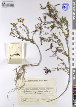
LE 01208561
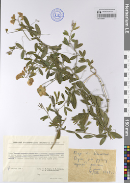
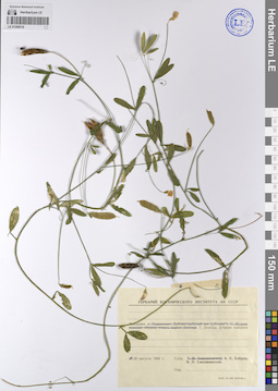
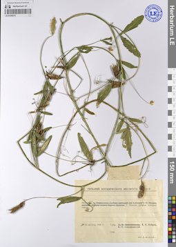
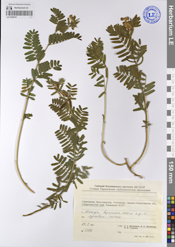
Lathyrus pratensis L. ⟮ID by scan⟯ det. Melnikov, Denis Germanovich at 02.06.2024
Collectors: Khort (Hort) Tatyana Petrovna; Bobrov, Andrej Evgenievich; Siplivinsky, Vladimir Nikolaevich Collection date: 07.08.1968. Administrative regions: RU - Republic of Crimea. Subregion: Белогорский район, Богатовское сельское поселение. Топоним: село Богатое (Бахчи-Эли Багъча Эли). Groups of specimens: Образцы сектора Восточной Европы; Соглашение Минобрнауки №075-15-2021-1056; Гербарий Ботанического института АН СССРOriginal label text:Крым. Село Богатое (Бахчи-Эли), луга по руслу горной речки.
Landscape in location of collection: теплоумеренный пояс, граница предгорных степей и субсредиземноморских лесовHabitat / plant community in location of collecting: луга по руслу горной речкиRecord creation: 2023-09-04, Artyom Borodushkin, PhotoScan D2.Citation: Specimen LE 01208561 // Virtual herbarium of Komarov Botanical Institute RAS — http://re.herbariumle.ru/01208561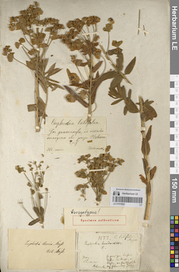
LE 01070922
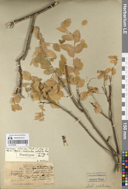
Groups of specimens: Образцы сектора Кавказа; Типовые образцы сектора Кавказа; Соглашение Минобрнауки №075-15-2021-1056Record creation: 2023-09-04, Elena Portenier, PhotoScan D2.Citation: Specimen LE 01070922 // Virtual herbarium of Komarov Botanical Institute RAS — http://re.herbariumle.ru/01070922
LE 01208677
Groups of specimens: Образцы сектора Восточной Европы; Соглашение Минобрнауки №075-15-2021-1056Record creation: 2023-09-05, Artyom Borodushkin, PhotoScan D2.Citation: Specimen LE 01208677 // Virtual herbarium of Komarov Botanical Institute RAS — http://re.herbariumle.ru/01208677
LE 01225306
Groups of specimens: Образцы сектора Кавказа; Соглашение Минобрнауки №075-15-2021-1056Record creation: 2023-09-05, Elena Portenier, PhotoScan D2.Citation: Specimen LE 01225306 // Virtual herbarium of Komarov Botanical Institute RAS — http://re.herbariumle.ru/01225306
LE 01208216
Lathyrus pratensis L. ⟮ID by scan⟯ det. Melnikov, Denis Germanovich at 02.06.2024
Collectors: Bobrov, Andrej Evgenievich; Siplivinsky, Vladimir Nikolaevich Collection date: 30.08.1968. Administrative regions: MD - Municipiul Balti. Топоним: Бельцы (Бэлць). Place of collection: севернее города Бельцы.Groups of specimens: Образцы сектора Восточной Европы; Соглашение Минобрнауки №075-15-2021-1056; Гербарий Ботанического института АН СССРOriginal label text:Молдавия. Город Бельцы, дубрава севернее города.
Landscape in location of collection: теплоумеренные лесостепиHabitat / plant community in location of collecting: дубраваRecord creation: 2023-09-04, Artyom Borodushkin, PhotoScan D2.Citation: Specimen LE 01208216 // Virtual herbarium of Komarov Botanical Institute RAS — http://re.herbariumle.ru/01208216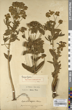
LE 01070921
Groups of specimens: Образцы сектора Кавказа; Типовые образцы сектора Кавказа; Соглашение Минобрнауки №075-15-2021-1056Record creation: 2023-09-04, Elena Portenier, PhotoScan D2.Citation: Specimen LE 01070921 // Virtual herbarium of Komarov Botanical Institute RAS — http://re.herbariumle.ru/01070921
LE 01208673
Groups of specimens: Образцы сектора Восточной Европы; Соглашение Минобрнауки №075-15-2021-1056Record creation: 2023-09-05, Artyom Borodushkin, PhotoScan D2.Citation: Specimen LE 01208673 // Virtual herbarium of Komarov Botanical Institute RAS — http://re.herbariumle.ru/01208673
LE 01071367
Groups of specimens: Образцы сектора Кавказа; Соглашение Минобрнауки №075-15-2021-1056Record creation: 2023-09-05, Elena Portenier, PhotoScan D2.Citation: Specimen LE 01071367 // Virtual herbarium of Komarov Botanical Institute RAS — http://re.herbariumle.ru/01071367
LE 01208215
Lathyrus sp.
Collectors: Bobrov, Andrej Evgenievich; Siplivinsky, Vladimir Nikolaevich Collection date: 30.08.1968. Administrative regions: MD - Municipiul Balti. Groups of specimens: Образцы сектора Восточной Европы; Соглашение Минобрнауки №075-15-2021-1056; Гербарий Ботанического института АН СССРOriginal label text:Молдавия. Город Бельцы, дубрава севернее города.
Record creation: 2023-09-04, Artyom Borodushkin, PhotoScan D2.Citation: Specimen LE 01208215 // Virtual herbarium of Komarov Botanical Institute RAS — http://re.herbariumle.ru/01208215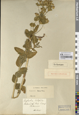
LE 01070920
Groups of specimens: Образцы сектора Кавказа; Типовые образцы сектора Кавказа; Соглашение Минобрнауки №075-15-2021-1056Record creation: 2023-09-04, Elena Portenier, PhotoScan D2.Citation: Specimen LE 01070920 // Virtual herbarium of Komarov Botanical Institute RAS — http://re.herbariumle.ru/01070920
LE 01208628
Groups of specimens: Образцы сектора Восточной Европы; Соглашение Минобрнауки №075-15-2021-1056Record creation: 2023-09-05, Artyom Borodushkin, PhotoScan D2.Citation: Specimen LE 01208628 // Virtual herbarium of Komarov Botanical Institute RAS — http://re.herbariumle.ru/01208628
LE 01071366
Groups of specimens: Образцы сектора Кавказа; Соглашение Минобрнауки №075-15-2021-1056Record creation: 2023-09-05, Elena Portenier, PhotoScan D2.Citation: Specimen LE 01071366 // Virtual herbarium of Komarov Botanical Institute RAS — http://re.herbariumle.ru/01071366
LE 01208214
Lathyrus tuberosus L. ⟮ID by scan⟯ det. Melnikov, Denis Germanovich at 02.06.2024
Collectors: Bobrov, Andrej Evgenievich; Siplivinsky, Vladimir Nikolaevich; Aleksandrova, V.P.; Belyanskaja, E.O.; Zaikonnikova, Tamara Ivanovna Collection date: 28.08.1968. Administrative regions: MD - Municipiul Chisinau. Топоним: дорога Кишинёв-Дубоссары. Place of collection: 30 километров от Кишинёва.Groups of specimens: Образцы сектора Восточной Европы; Соглашение Минобрнауки №075-15-2021-1056; Гербарий Ботанического института АН СССРOriginal label text:Молдавия, дорога Кишинёв-Дубоссары, 30 километров от Кишинёва. Дубрава в глубоком овраге.
Landscape in location of collection: теплоумеренные лесостепиHabitat / plant community in location of collecting: дубрава в глубоком оврагеRecord creation: 2023-09-04, Artyom Borodushkin, PhotoScan D2.Citation: Specimen LE 01208214 // Virtual herbarium of Komarov Botanical Institute RAS — http://re.herbariumle.ru/01208214
LE 01070919
Groups of specimens: Образцы сектора Кавказа; Типовые образцы сектора Кавказа; Соглашение Минобрнауки №075-15-2021-1056Record creation: 2023-09-04, Elena Portenier, PhotoScan D2.Citation: Specimen LE 01070919 // Virtual herbarium of Komarov Botanical Institute RAS — http://re.herbariumle.ru/01070919
LE 01208626
Groups of specimens: Образцы сектора Восточной Европы; Соглашение Минобрнауки №075-15-2021-1056Record creation: 2023-09-05, Artyom Borodushkin, PhotoScan D2.Citation: Specimen LE 01208626 // Virtual herbarium of Komarov Botanical Institute RAS — http://re.herbariumle.ru/01208626
LE 01071365
Groups of specimens: Образцы сектора Кавказа; Соглашение Минобрнауки №075-15-2021-1056Record creation: 2023-09-05, Elena Portenier, PhotoScan D2.Citation: Specimen LE 01071365 // Virtual herbarium of Komarov Botanical Institute RAS — http://re.herbariumle.ru/01071365
LE 01208213
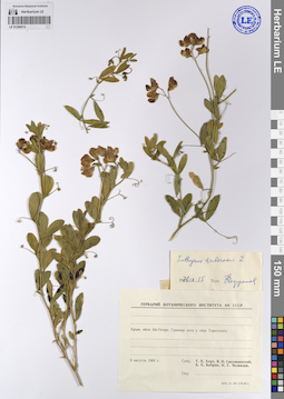
Lathyrus tuberosus L. det. Chedereshov, Z. at 15.09.1976
Collectors: Khort (Hort) Tatyana Petrovna; Siplivinsky, Vladimir Nikolaevich; Bobrov, Andrej Evgenievich; Tchelintzev, N.G. Collection date: 09.08.1968. Administrative regions: RU - Republic of Crimea. Groups of specimens: Образцы сектора Восточной Европы; Соглашение Минобрнауки №075-15-2021-1056; Гербарий Ботанического института АН СССРOriginal label text:Крым, яйла Ай-Петри. Граница леса у скал Тарахташи.
Record creation: 2023-09-04, Artyom Borodushkin, PhotoScan D2.Citation: Specimen LE 01208213 // Virtual herbarium of Komarov Botanical Institute RAS — http://re.herbariumle.ru/01208213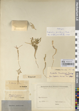
LE 01070918
Groups of specimens: Образцы сектора Кавказа; Типовые образцы сектора Кавказа; Соглашение Минобрнауки №075-15-2021-1056Record creation: 2023-09-04, Elena Portenier, PhotoScan D2.Citation: Specimen LE 01070918 // Virtual herbarium of Komarov Botanical Institute RAS — http://re.herbariumle.ru/01070918
LE 01208623
Groups of specimens: Образцы сектора Восточной Европы; Соглашение Минобрнауки №075-15-2021-1056Record creation: 2023-09-05, Artyom Borodushkin, PhotoScan D2.Citation: Specimen LE 01208623 // Virtual herbarium of Komarov Botanical Institute RAS — http://re.herbariumle.ru/01208623
LE 01071323
Groups of specimens: Образцы сектора Кавказа; Соглашение Минобрнауки №075-15-2021-1056Record creation: 2023-09-05, Elena Portenier, PhotoScan D2.Citation: Specimen LE 01071323 // Virtual herbarium of Komarov Botanical Institute RAS — http://re.herbariumle.ru/01071323
LE 01208192
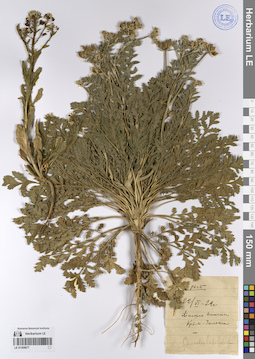
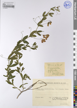
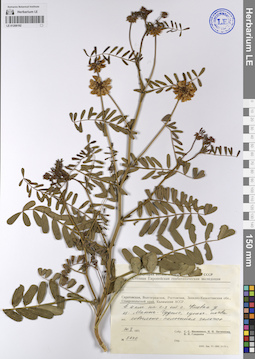
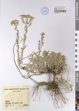
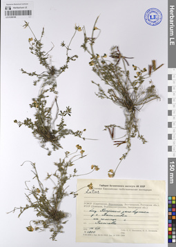
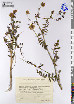
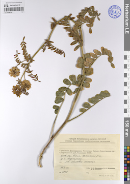
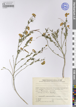
Coronilla varia L. ⟮ID by scan⟯ det. Melnikov, Denis Germanovich at 02.06.2024
Collectors: Litvinova, N.P. Field collecting number: 5430. Collection date: 30.05.1971. Administrative regions: RU - Stavropol'skiy Kray - Apanasenkovskiy Rayon. Subregion: Апанасенковский муниципальный округ. Топоним: озеро Маныч-Гудило - Калмыкия, Ставропольский край, Ростовская область. Place of collection: в 4 километрах на северо-запад от села Киевка у озера Маныч-Гудило.Expedition: АН СССР Степная Европейская геоботаническая экспедиция ()Groups of specimens: Образцы сектора Восточной Европы; Соглашение Минобрнауки №075-15-2021-1056Original label text:Ставропольский край, в 4 километрах на северо-запад от села Киевка у озера Маныч-Гудило, супесчаная почва ковыльно-типчаковая залежь
Landscape in location of collection: степиHabitat / plant community in location of collecting: супесчаная почва ковыльно-типчаковая залежьRecord creation: 2023-09-04, Artyom Borodushkin, PhotoScan D2.Citation: Specimen LE 01208192 // Virtual herbarium of Komarov Botanical Institute RAS — http://re.herbariumle.ru/01208192
LE 01070917
Groups of specimens: Образцы сектора Кавказа; Типовые образцы сектора Кавказа; Соглашение Минобрнауки №075-15-2021-1056Record creation: 2023-09-04, Elena Portenier, PhotoScan D2.Citation: Specimen LE 01070917 // Virtual herbarium of Komarov Botanical Institute RAS — http://re.herbariumle.ru/01070917
LE 01208576
Groups of specimens: Образцы сектора Восточной Европы; Соглашение Минобрнауки №075-15-2021-1056Record creation: 2023-09-05, Artyom Borodushkin, PhotoScan D2.Citation: Specimen LE 01208576 // Virtual herbarium of Komarov Botanical Institute RAS — http://re.herbariumle.ru/01208576
LE 01071322
Groups of specimens: Образцы сектора Кавказа; Соглашение Минобрнауки №075-15-2021-1056Record creation: 2023-09-05, Elena Portenier, PhotoScan D2.Citation: Specimen LE 01071322 // Virtual herbarium of Komarov Botanical Institute RAS — http://re.herbariumle.ru/01071322
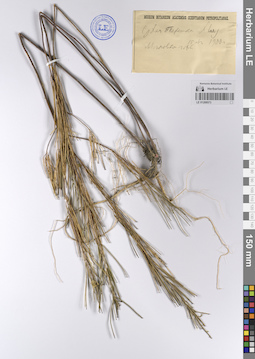
LE 01208191
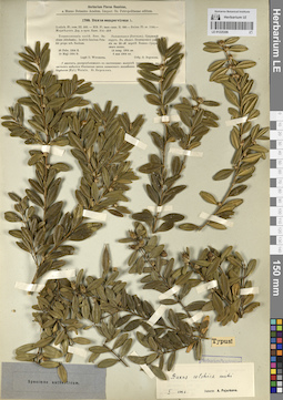
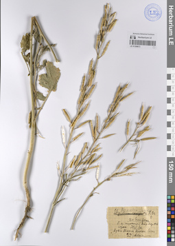
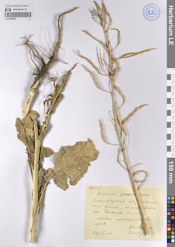
Vicia cassubica L. ⟮prelim. ID⟯ det. Melnikov, Denis Germanovich at 02.06.2024
Collectors: Litvinova, N.P. Field collecting number: 5386. Collection date: 26.05.1971. Administrative regions: RU - Stavropol'skiy Kray. Subregion: городской округ город-курорт Пятигорск. Топоним: гора Машук. Place of collection: город Пятигорск, вершина горы Машук, 990 метров над уровнем моря.Expedition: Степная Европейская геоботаническая экспедиция (1970 -1971)Groups of specimens: Образцы сектора Восточной Европы; Соглашение Минобрнауки №075-15-2021-1056Original label text:Ставропольский край, гора Машук, вершина 990 метров над уровнем моря луговая степь
Landscape in location of collection: горыHabitat / plant community in location of collecting: луговая степьCoordinates (geographic position): 990 m a.s.l.Record creation: 2023-09-04, Artyom Borodushkin, PhotoScan D2.Citation: Specimen LE 01208191 // Virtual herbarium of Komarov Botanical Institute RAS — http://re.herbariumle.ru/01208191
LE 01070916
Groups of specimens: Образцы сектора Кавказа; Типовые образцы сектора Кавказа; Соглашение Минобрнауки №075-15-2021-1056Record creation: 2023-09-04, Elena Portenier, PhotoScan D2.Citation: Specimen LE 01070916 // Virtual herbarium of Komarov Botanical Institute RAS — http://re.herbariumle.ru/01070916
LE 01071321
Groups of specimens: Образцы сектора Кавказа; Соглашение Минобрнауки №075-15-2021-1056Record creation: 2023-09-05, Elena Portenier, PhotoScan D2.Citation: Specimen LE 01071321 // Virtual herbarium of Komarov Botanical Institute RAS — http://re.herbariumle.ru/01071321
LE 01208575
Groups of specimens: Образцы сектора Восточной Европы; Соглашение Минобрнауки №075-15-2021-1056Record creation: 2023-09-05, Artyom Borodushkin, PhotoScan D2.Citation: Specimen LE 01208575 // Virtual herbarium of Komarov Botanical Institute RAS — http://re.herbariumle.ru/01208575
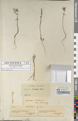
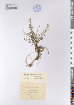
LE 01208188
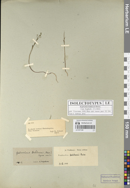
Lotus sp. det. Ikonnikov, Sergei Sergeevich, Litvinova, N.P. at 14.08.1970
Collectors: Ikonnikov, Sergei Sergeevich; Litvinova, N.P. Field collecting number: 4200. Collection date: 14.08.1970. Administrative regions: RU - Voronezhskaya Oblast'. Expedition: Степная Европейская геоботаническая экспедиция (1970 -1971)Groups of specimens: Образцы сектора Восточной Европы; Соглашение Минобрнауки №075-15-2021-1056Original label text:РСФСР (Воронежская область), близ Хоперского заповедника у села Васильевка на солонце с Puccinella
Record creation: 2023-09-04, Artyom Borodushkin, PhotoScan D2.Citation: Specimen LE 01208188 // Virtual herbarium of Komarov Botanical Institute RAS — http://re.herbariumle.ru/01208188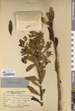
LE 01070915
Groups of specimens: Образцы сектора Кавказа; Типовые образцы сектора Кавказа; Соглашение Минобрнауки №075-15-2021-1056Record creation: 2023-09-04, Elena Portenier, PhotoScan D2.Citation: Specimen LE 01070915 // Virtual herbarium of Komarov Botanical Institute RAS — http://re.herbariumle.ru/01070915
LE 01071320
Groups of specimens: Образцы сектора Кавказа; Соглашение Минобрнауки №075-15-2021-1056Record creation: 2023-09-05, Elena Portenier, PhotoScan D2.Citation: Specimen LE 01071320 // Virtual herbarium of Komarov Botanical Institute RAS — http://re.herbariumle.ru/01071320
LE 01208574
Groups of specimens: Образцы сектора Восточной Европы; Соглашение Минобрнауки №075-15-2021-1056Record creation: 2023-09-05, Artyom Borodushkin, PhotoScan D2.Citation: Specimen LE 01208574 // Virtual herbarium of Komarov Botanical Institute RAS — http://re.herbariumle.ru/01208574
LE 01208187
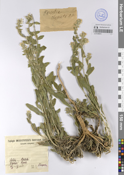
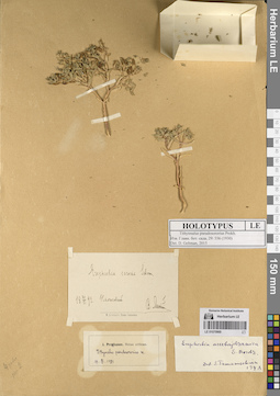
Lotus sp.
Collectors: Ikonnikov, Sergei Sergeevich; Litvinova, N.P. Field collecting number: 4432. Collection date: 19.08.1970. Administrative regions: RU - Belgorodskaya Oblast' - Roven'skiy Rayon. Expedition: Степная Европейская геоботаническая экспедиция (1970 -1971)Groups of specimens: Образцы сектора Восточной Европы; Соглашение Минобрнауки №075-15-2021-1056Original label text:РСФСР (Белгородская область), Ровенский район, правый берег реки Айдар у села Ровеньки на мелах
Record creation: 2023-09-04, Artyom Borodushkin, PhotoScan D2.Citation: Specimen LE 01208187 // Virtual herbarium of Komarov Botanical Institute RAS — http://re.herbariumle.ru/01208187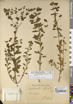
LE 01070914
Groups of specimens: Образцы сектора Кавказа; Типовые образцы сектора Кавказа; Соглашение Минобрнауки №075-15-2021-1056Record creation: 2023-09-04, Elena Portenier, PhotoScan D2.Citation: Specimen LE 01070914 // Virtual herbarium of Komarov Botanical Institute RAS — http://re.herbariumle.ru/01070914
LE 01071318
Groups of specimens: Образцы сектора Кавказа; Соглашение Минобрнауки №075-15-2021-1056Record creation: 2023-09-05, Elena Portenier, PhotoScan D2.Citation: Specimen LE 01071318 // Virtual herbarium of Komarov Botanical Institute RAS — http://re.herbariumle.ru/01071318
LE 01208573
Groups of specimens: Образцы сектора Восточной Европы; Соглашение Минобрнауки №075-15-2021-1056Record creation: 2023-09-05, Artyom Borodushkin, PhotoScan D2.Citation: Specimen LE 01208573 // Virtual herbarium of Komarov Botanical Institute RAS — http://re.herbariumle.ru/01208573
LE 01208186
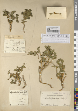
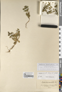
Coronilla varia L. ⟮ID by scan⟯ det. Melnikov, Denis Germanovich at 02.06.2024
Collectors: Ikonnikov, Sergei Sergeevich; Litvinova, N.P.; Gladkova, Valentina Nikolaevna Field collecting number: 6010. Collection date: 15.06.1971. Administrative regions: RU - Volgogradskaya Oblast' - Kletskiy Rayon. Топоним: село Подгорное, Клетский район (современные данные отсутствуют). Place of collection: правый берег Дона, у села Подгорное.Expedition: Степная Европейская геоботаническая экспедиция (1970 -1971)Groups of specimens: Образцы сектора Восточной Европы; Соглашение Минобрнауки №075-15-2021-1056Original label text:РСФСР (Волгоградская область), правый берег Дона, Клетский район, у села Подгорное на меловых обнажениях
Landscape in location of collection: степиHabitat / plant community in location of collecting: на меловых обнаженияхSubstrate in collecting location: chalkRecord creation: 2023-09-04, Artyom Borodushkin, PhotoScan D2.Citation: Specimen LE 01208186 // Virtual herbarium of Komarov Botanical Institute RAS — http://re.herbariumle.ru/01208186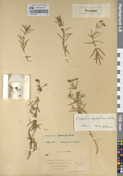
LE 01070913
Groups of specimens: Образцы сектора Кавказа; Типовые образцы сектора Кавказа; Соглашение Минобрнауки №075-15-2021-1056Record creation: 2023-09-04, Elena Portenier, PhotoScan D2.Citation: Specimen LE 01070913 // Virtual herbarium of Komarov Botanical Institute RAS — http://re.herbariumle.ru/01070913
LE 01070969
Groups of specimens: Образцы сектора Кавказа; Соглашение Минобрнауки №075-15-2021-1056Record creation: 2023-09-05, Elena Portenier, PhotoScan D2.Citation: Specimen LE 01070969 // Virtual herbarium of Komarov Botanical Institute RAS — http://re.herbariumle.ru/01070969
LE 01208572
Groups of specimens: Образцы сектора Восточной Европы; Соглашение Минобрнауки №075-15-2021-1056Record creation: 2023-09-05, Artyom Borodushkin, PhotoScan D2.Citation: Specimen LE 01208572 // Virtual herbarium of Komarov Botanical Institute RAS — http://re.herbariumle.ru/01208572
LE 01208185
Coronilla varia L. ⟮ID by scan⟯ det. Melnikov, Denis Germanovich at 02.06.2024
Collectors: Ikonnikov, Sergei Sergeevich; Litvinova, N.P.; Gladkova, Valentina Nikolaevna Field collecting number: 5939. Collection date: 15.06.1971. Administrative regions: RU - Volgogradskaya Oblast' - Kletskiy Rayon. Топоним: село Подгорное, Клетский район (современные данные отсутствуют). Place of collection: правый берег Дона, у села Подгорное.Expedition: Степная Европейская геоботаническая экспедиция (1970 -1971)Groups of specimens: Образцы сектора Восточной Европы; Соглашение Минобрнауки №075-15-2021-1056Original label text:РСФСР (Волгоградская область), правый берег Дона, Клетский район, у села Подгорное на меловых склонах
Landscape in location of collection: степиHabitat / plant community in location of collecting: на меловых склонахSubstrate in collecting location: chalkRecord creation: 2023-09-04, Artyom Borodushkin, PhotoScan D2.Citation: Specimen LE 01208185 // Virtual herbarium of Komarov Botanical Institute RAS — http://re.herbariumle.ru/01208185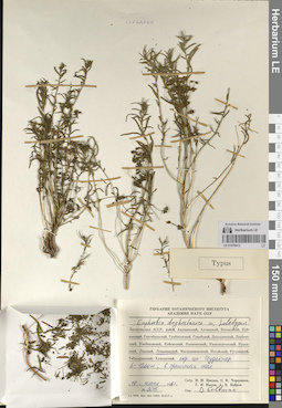
LE 01070912
Groups of specimens: Образцы сектора Кавказа; Типовые образцы сектора Кавказа; Соглашение Минобрнауки №075-15-2021-1056Record creation: 2023-09-04, Elena Portenier, PhotoScan D2.Citation: Specimen LE 01070912 // Virtual herbarium of Komarov Botanical Institute RAS — http://re.herbariumle.ru/01070912
LE 01070968
Groups of specimens: Образцы сектора Кавказа; Соглашение Минобрнауки №075-15-2021-1056Record creation: 2023-09-05, Elena Portenier, PhotoScan D2.Citation: Specimen LE 01070968 // Virtual herbarium of Komarov Botanical Institute RAS — http://re.herbariumle.ru/01070968
LE 01208571
Groups of specimens: Образцы сектора Восточной Европы; Соглашение Минобрнауки №075-15-2021-1056Record creation: 2023-09-05, Artyom Borodushkin, PhotoScan D2.Citation: Specimen LE 01208571 // Virtual herbarium of Komarov Botanical Institute RAS — http://re.herbariumle.ru/01208571
LE 01208184
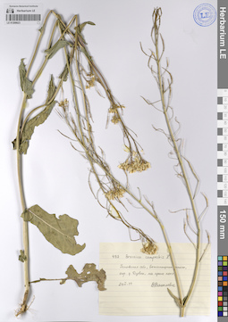
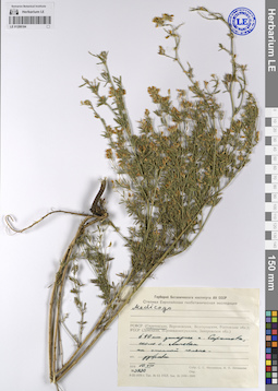
Medicago sativa L. det. Ikonnikov, Sergei Sergeevich, Litvinova, N.P. at 10.08.1970
Collectors: Ikonnikov, Sergei Sergeevich; Litvinova, N.P. Field collecting number: 3930. Collection date: 10.08.1970. Administrative regions: RU - Saratovskaya Oblast'. Expedition: Степная Европейская геоботаническая экспедиция (1970 -1971)Groups of specimens: Образцы сектора Восточной Европы; Соглашение Минобрнауки №075-15-2021-1056Original label text:РСФСР (Саратовская область), в 40 километрах западнее города Саратова, около села Липовка на степной поляне. дубрава
Record creation: 2023-09-04, Artyom Borodushkin, PhotoScan D2.Citation: Specimen LE 01208184 // Virtual herbarium of Komarov Botanical Institute RAS — http://re.herbariumle.ru/01208184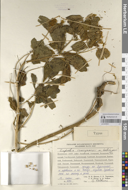
LE 01070911
Groups of specimens: Образцы сектора Кавказа; Типовые образцы сектора Кавказа; Соглашение Минобрнауки №075-15-2021-1056Record creation: 2023-09-04, Elena Portenier, PhotoScan D2.Citation: Specimen LE 01070911 // Virtual herbarium of Komarov Botanical Institute RAS — http://re.herbariumle.ru/01070911
LE 01070967
Groups of specimens: Образцы сектора Кавказа; Соглашение Минобрнауки №075-15-2021-1056Record creation: 2023-09-05, Elena Portenier, PhotoScan D2.Citation: Specimen LE 01070967 // Virtual herbarium of Komarov Botanical Institute RAS — http://re.herbariumle.ru/01070967
LE 01208568
Groups of specimens: Образцы сектора Восточной Европы; Соглашение Минобрнауки №075-15-2021-1056Record creation: 2023-09-05, Artyom Borodushkin, PhotoScan D2.Citation: Specimen LE 01208568 // Virtual herbarium of Komarov Botanical Institute RAS — http://re.herbariumle.ru/01208568
LE 01208183
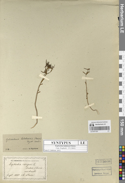
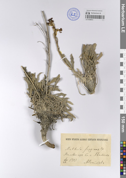
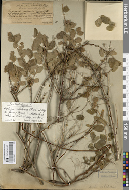
Medicago falcata L. ⟮ID by scan⟯ det. Melnikov, Denis Germanovich at 02.06.2024
Collectors: Ikonnikov, Sergei Sergeevich; Litvinova, N.P. Field collecting number: 4898. Collection date: 28.08.1970. Administrative regions: RU - Russian Federation. Subregion: Донецкая Народная Республика, Шахтерский район. Топоним: заповедник Каменные могилы, Донецкая Народная Республика. Place of collection: в 7 километрах юго-восточнее станции Розовка.Expedition: Степная Европейская геоботаническая экспедиция (1970 -1971)Groups of specimens: Образцы сектора Восточной Европы; Соглашение Минобрнауки №075-15-2021-1056Original label text:УССР (Донецкая область), заповедник Каменные могилы (в 7 километрах юго-восточнее станции Розовка) злаково-разнотравная степь
Landscape in location of collection: степиHabitat / plant community in location of collecting: злаково-разнотравная степьRecord creation: 2023-09-04, Artyom Borodushkin, PhotoScan D2.Citation: Specimen LE 01208183 // Virtual herbarium of Komarov Botanical Institute RAS — http://re.herbariumle.ru/01208183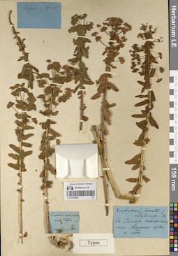
LE 01070909
Groups of specimens: Образцы сектора Кавказа; Типовые образцы сектора Кавказа; Соглашение Минобрнауки №075-15-2021-1056Record creation: 2023-09-04, Elena Portenier, PhotoScan D2.Citation: Specimen LE 01070909 // Virtual herbarium of Komarov Botanical Institute RAS — http://re.herbariumle.ru/01070909