View
Add
Copy
Edit
Delete
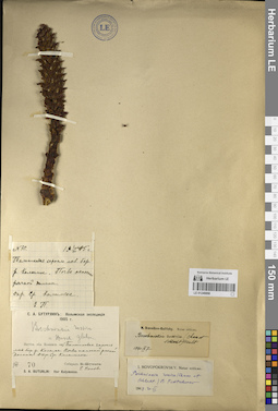
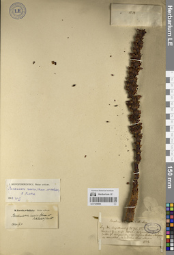
LE 01249947
Mannagettaea hummelii Harry Sm. det. Peschkova, Galina Alexandrovna
Collectors: Peschkova, Galina Alexandrovna Administrative regions: RU - Respublika Buryatiya - Tunkinskiy Rayon. Groups of specimens: Образцы сектора Сибири и Дальнего Востока России; Соглашение Минобрнауки №075-15-2021-1056Coordinates (geographic position): 51° 37′ 16.08″ N, 101° 40′ 15.22″ E ±1000 mRecord creation: 2023-09-13, Marina Yarichina, PhotoScan D2.Citation: Specimen LE 01249947 // Virtual herbarium of Komarov Botanical Institute RAS — http://re.herbariumle.ru/01249947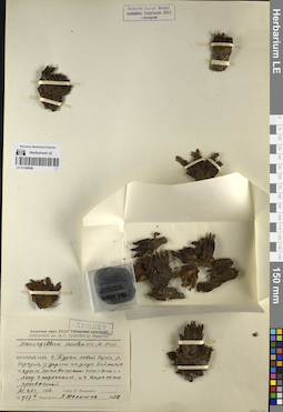
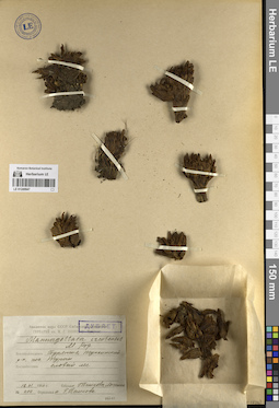
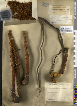
LE 01249946
Mannagettaea ircutensis Popov det. Malyshev, Leonid Ivanovich
Collectors: Malyshev, Leonid Ivanovich Administrative regions: RU - Respublika Buryatiya - Tunkinskiy Rayon. Groups of specimens: Образцы сектора Сибири и Дальнего Востока России; Соглашение Минобрнауки №075-15-2021-1056Coordinates (geographic position): 51° 39′ 7.52″ N, 101° 40′ 56.72″ E ±500 mRecord creation: 2023-09-13, Marina Yarichina, PhotoScan D2.Citation: Specimen LE 01249946 // Virtual herbarium of Komarov Botanical Institute RAS — http://re.herbariumle.ru/01249946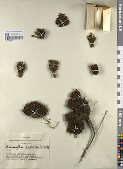
LE 01249945
Mannagettaea hummelii Harry Sm. det. Grubov, Valery Ivanovich
Collectors: Grubov, Valery Ivanovich; Khanminchun, Valerij Mikhailovich Administrative regions: RU - Respublika Tyva - Erzinskiy Rayon. Groups of specimens: Образцы сектора Сибири и Дальнего Востока России; Соглашение Минобрнауки №075-15-2021-1056Coordinates (geographic position): 50° 12′ 38.02″ N, 95° 30′ 49.49″ E ±500 mRecord creation: 2023-09-13, Marina Yarichina, PhotoScan D2.Citation: Specimen LE 01249945 // Virtual herbarium of Komarov Botanical Institute RAS — http://re.herbariumle.ru/01249945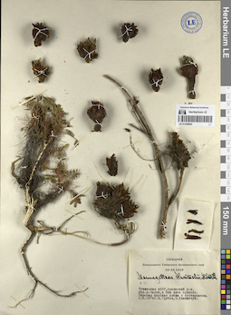
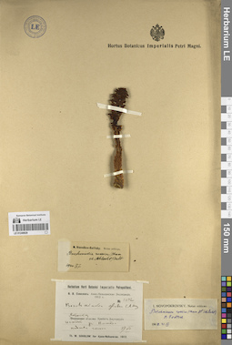
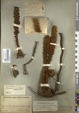
LE 01249944
Mannagettaea hummelii Harry Sm. det. Grubov, Valery Ivanovich
Collectors: Grubov, Valery Ivanovich; Khanminchun, Valerij Mikhailovich Administrative regions: RU - Respublika Tyva - Erzinskiy Rayon. Groups of specimens: Образцы сектора Сибири и Дальнего Востока России; Соглашение Минобрнауки №075-15-2021-1056Coordinates (geographic position): 50° 12′ 35.78″ N, 95° 30′ 55.6″ E ±500 mRecord creation: 2023-09-13, Marina Yarichina, PhotoScan D2.Citation: Specimen LE 01249944 // Virtual herbarium of Komarov Botanical Institute RAS — http://re.herbariumle.ru/01249944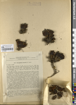
LE 01249943
Mannagettaea hummelii Harry Sm.
Collectors: Grubov, Valery Ivanovich; Khanminchun, Valerij Mikhailovich Administrative regions: RU - Respublika Tyva - Erzinskiy Rayon. Groups of specimens: Образцы сектора Сибири и Дальнего Востока России; Соглашение Минобрнауки №075-15-2021-1056; Гербарий Флоры СССР, издаваемый Ботаническим институтом им. В. Л. Комарова Академии наук СССРCoordinates (geographic position): 50° 12′ 32.08″ N, 95° 31′ 18.74″ E ±500 mRecord creation: 2023-09-13, Marina Yarichina, PhotoScan D2.Citation: Specimen LE 01249943 // Virtual herbarium of Komarov Botanical Institute RAS — http://re.herbariumle.ru/01249943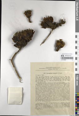
LE 01249942
Mannagettaea hummelii Harry Sm.
Collectors: Grubov, Valery Ivanovich; Khanminchun, Valerij Mikhailovich Administrative regions: RU - Respublika Tyva - Erzinskiy Rayon. Groups of specimens: Образцы сектора Сибири и Дальнего Востока России; Соглашение Минобрнауки №075-15-2021-1056; Гербарий Флоры СССР, издаваемый Ботаническим институтом им. В. Л. Комарова Академии наук СССРCoordinates (geographic position): 50° 12′ 38.59″ N, 95° 31′ 15.97″ E ±500 mRecord creation: 2023-09-13, Marina Yarichina, PhotoScan D2.Citation: Specimen LE 01249942 // Virtual herbarium of Komarov Botanical Institute RAS — http://re.herbariumle.ru/01249942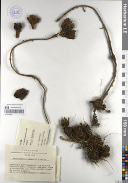
LE 01249941
Mannagettaea hummelii Harry Sm.
Collectors: Krasnoborov, Ivan Moiseevich; Khanminchun, Valerij Mikhailovich Administrative regions: RU - Respublika Tyva - Kaa-Khemskiy Rayon. Groups of specimens: Образцы сектора Сибири и Дальнего Востока России; Соглашение Минобрнауки №075-15-2021-1056Record creation: 2023-09-13, Marina Yarichina, PhotoScan D2.Citation: Specimen LE 01249941 // Virtual herbarium of Komarov Botanical Institute RAS — http://re.herbariumle.ru/01249941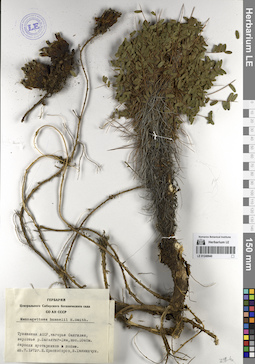
LE 01249940
Mannagettaea hummelii Harry Sm.
Collectors: Krasnoborov, Ivan Moiseevich; Khanminchun, Valerij Mikhailovich Administrative regions: RU - Respublika Tyva - Kaa-Khemskiy Rayon. Groups of specimens: Образцы сектора Сибири и Дальнего Востока России; Соглашение Минобрнауки №075-15-2021-1056Coordinates (geographic position): 52° 0′ 37.98″ N, 95° 56′ 26.65″ E ±1000 mRecord creation: 2023-09-13, Marina Yarichina, PhotoScan D2.Citation: Specimen LE 01249940 // Virtual herbarium of Komarov Botanical Institute RAS — http://re.herbariumle.ru/01249940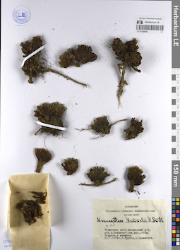
LE 01249939
Mannagettaea hummelii Harry Sm.
Collectors: Grubov, Valery Ivanovich; Khanminchun, Valerij Mikhailovich Administrative regions: RU - Respublika Tyva - Kyzylskiy Rayon. Groups of specimens: Образцы сектора Сибири и Дальнего Востока России; Соглашение Минобрнауки №075-15-2021-1056Record creation: 2023-09-13, Marina Yarichina, PhotoScan D2.Citation: Specimen LE 01249939 // Virtual herbarium of Komarov Botanical Institute RAS — http://re.herbariumle.ru/01249939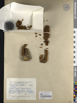
LE 01249938
Boschniakia rossica (Cham. & Schltdl.) B. Fedtsch.
Collectors: Tjulina (Tyulina), Lyudmila Nikolaevna Administrative regions: RU - Respublika Sakha (Yakutiya). Subregion: Нерюнгринский район. Groups of specimens: Образцы сектора Сибири и Дальнего Востока России; Соглашение Минобрнауки №075-15-2021-1056Record creation: 2023-09-13, Marina Yarichina, PhotoScan D2.Citation: Specimen LE 01249938 // Virtual herbarium of Komarov Botanical Institute RAS — http://re.herbariumle.ru/01249938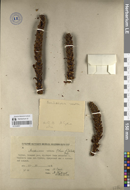
LE 01249937
Boschniakia rossica (Cham. & Schltdl.) B. Fedtsch. det. Kuvaev, Vladimir Borisovich
Collectors: Sukhikh, M. Administrative regions: RU - Respublika Sakha (Yakutiya) - Lenskiy Rayon. Groups of specimens: Образцы сектора Сибири и Дальнего Востока России; Соглашение Минобрнауки №075-15-2021-1056Coordinates (geographic position): 60° 42′ 5.2″ N, 114° 54′ 54.36″ E ±500 mRecord creation: 2023-09-13, Marina Yarichina, PhotoScan D2.Citation: Specimen LE 01249937 // Virtual herbarium of Komarov Botanical Institute RAS — http://re.herbariumle.ru/01249937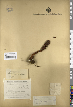
LE 01249936
Boschniakia rossica (Cham. & Schltdl.) B. Fedtsch. det. Ikonnikov-Galitzky, Nikolai Petrovic
Additional identifications: Boschniakia glabra C.A. Mey. ex Bong. det. Komarov, Vladimir Leontjevich; Boschniakia rossica (Cham. & Schltdl.) B. Fedtsch. det. Novopokrovsky, Ivan Vassiljevich Collectors: Sokolov, Ph.V. Administrative regions: RU - Khabarovskiy Kray - Ayano-Mayskiy Rayon. Groups of specimens: Образцы сектора Сибири и Дальнего Востока России; Соглашение Минобрнауки №075-15-2021-1056Coordinates (geographic position): 56° 31′ 6.19″ N, 137° 3′ 54.17″ E ±2000 mRecord creation: 2023-09-13, Marina Yarichina, PhotoScan D2.Citation: Specimen LE 01249936 // Virtual herbarium of Komarov Botanical Institute RAS — http://re.herbariumle.ru/01249936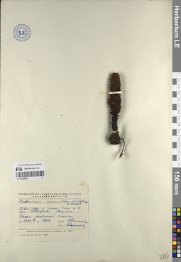
LE 01249935
Boschniakia rossica (Cham. & Schltdl.) B. Fedtsch.
Collectors: Ovczinnikov, Pavel Nikolaevich Administrative regions: RU - Respublika Sakha (Yakutiya) - Bulunsky District. Groups of specimens: Образцы сектора Сибири и Дальнего Востока России; Соглашение Минобрнауки №075-15-2021-1056Coordinates (geographic position): 70° 14′ 3.02″ N, 126° 1′ 17.82″ E ±300 mRecord creation: 2023-09-13, Marina Yarichina, PhotoScan D2.Citation: Specimen LE 01249935 // Virtual herbarium of Komarov Botanical Institute RAS — http://re.herbariumle.ru/01249935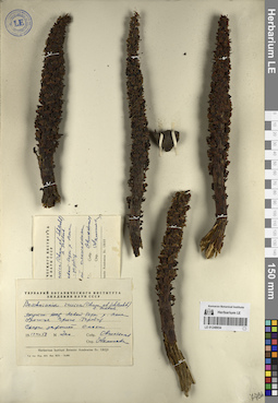
LE 01249934
Boschniakia rossica (Cham. & Schltdl.) B. Fedtsch.
Collectors: Ovczinnikov, Pavel Nikolaevich Administrative regions: RU - Respublika Sakha (Yakutiya) - Bulunsky District. Groups of specimens: Образцы сектора Сибири и Дальнего Востока России; Соглашение Минобрнауки №075-15-2021-1056Record creation: 2023-09-13, Marina Yarichina, PhotoScan D2.Citation: Specimen LE 01249934 // Virtual herbarium of Komarov Botanical Institute RAS — http://re.herbariumle.ru/01249934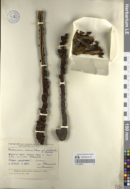
LE 01249933
Boschniakia rossica (Cham. & Schltdl.) B. Fedtsch.
Collectors: Ovczinnikov, Pavel Nikolaevich Administrative regions: RU - Respublika Sakha (Yakutiya) - Bulunsky District. Groups of specimens: Образцы сектора Сибири и Дальнего Востока России; Соглашение Минобрнауки №075-15-2021-1056Coordinates (geographic position): 70° 14′ 9.97″ N, 126° 0′ 40.65″ E ±300 mRecord creation: 2023-09-13, Marina Yarichina, PhotoScan D2.Citation: Specimen LE 01249933 // Virtual herbarium of Komarov Botanical Institute RAS — http://re.herbariumle.ru/01249933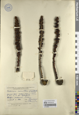
LE 01249932
Boschniakia rossica (Cham. & Schltdl.) B. Fedtsch.
Collectors: Ovczinnikov, Pavel Nikolaevich Administrative regions: RU - Respublika Sakha (Yakutiya) - Bulunsky District. Groups of specimens: Образцы сектора Сибири и Дальнего Востока России; Соглашение Минобрнауки №075-15-2021-1056Coordinates (geographic position): 70° 14′ 22.62″ N, 126° 1′ 1.63″ E ±300 mRecord creation: 2023-09-13, Marina Yarichina, PhotoScan D2.Citation: Specimen LE 01249932 // Virtual herbarium of Komarov Botanical Institute RAS — http://re.herbariumle.ru/01249932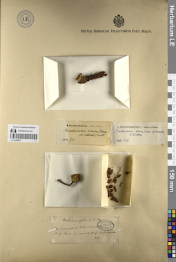
LE 01249931
Boschniakia rossica (Cham. & Schltdl.) B. Fedtsch. det. Ikonnikov-Galitzky, Nikolai Petrovic
Additional identifications: Boschniakia glabra C.A. Mey. ex Bong. det. Trautvetter, Rudolf Ernst von; Boschniakia rossica (Cham. & Schltdl.) B. Fedtsch. det. Novopokrovsky, Ivan Vassiljevich Collectors: Czekanowski, Alexander Piotr; Müller (Mueller), Ferdinand Ferdinandovich Field collecting number: 3670. Collection date: 15.07.1874. Administrative regions: RU - Respublika Sakha (Yakutiya) - Olenyoksky District. Топоним: Средняя Майгда (река Чоной-Майындата). Groups of specimens: Образцы сектора Сибири и Дальнего Востока России; Соглашение Минобрнауки №075-15-2021-1056Original label text:Ad fl. Olenek, procul ab ostia Maigda mediae.
Coordinates (geographic position): 67° 12′ 29.44″ N, 110° 10′ 35.14″ E ±1000 mRecord creation: 2023-09-13, Marina Yarichina, PhotoScan D2.Citation: Specimen LE 01249931 // Virtual herbarium of Komarov Botanical Institute RAS — http://re.herbariumle.ru/01249931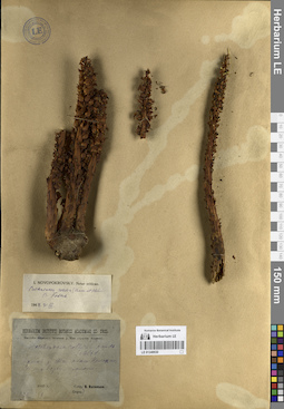
LE 01249930
Boschniakia rossica (Cham. & Schltdl.) B. Fedtsch. det. Novopokrovsky, Ivan Vassiljevich at 31.03.1948
Collectors: Vassiljev, Viktor Nikolayevich Field collecting number: 189. Collection date: 1935. Administrative regions: RU - Khabarovskiy Kray - Ayano-Mayskiy Rayon. Groups of specimens: Образцы сектора Сибири и Дальнего Востока России; Соглашение Минобрнауки №075-15-2021-1056Original label text:Бассейн верхнего течения р. Маи (приток Алдана).
Coordinates (geographic position): 57° 38′ 55.34″ N, 136° 9′ 48.16″ E ±1000 mRecord creation: 2023-09-13, Marina Yarichina, PhotoScan D2.Citation: Specimen LE 01249930 // Virtual herbarium of Komarov Botanical Institute RAS — http://re.herbariumle.ru/01249930Дельта р. Маи около Нелькана, лес по берегу протоки.
LE 01249929
Boschniakia rossica (Cham. & Schltdl.) B. Fedtsch. det. Ikonnikov-Galitzky, Nikolai Petrovic
Additional identifications: Boschniakia glabra C.A. Mey. ex Bong. det. Komarov, Vladimir Leontjevich; Boschniakia rossica (Cham. & Schltdl.) B. Fedtsch. det. Novopokrovsky, Ivan Vassiljevich Collectors: Sokolov, Ph.V. Administrative regions: RU - Khabarovskiy Kray - Ayano-Mayskiy Rayon. Groups of specimens: Образцы сектора Сибири и Дальнего Востока России; Соглашение Минобрнауки №075-15-2021-1056Coordinates (geographic position): 56° 34′ 25.13″ N, 137° 12′ 27.53″ E ±2000 mRecord creation: 2023-09-13, Marina Yarichina, PhotoScan D2.Citation: Specimen LE 01249929 // Virtual herbarium of Komarov Botanical Institute RAS — http://re.herbariumle.ru/01249929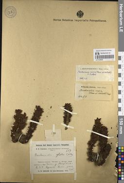
LE 01249928
Boschniakia rossica (Cham. & Schltdl.) B. Fedtsch. det. Ikonnikov-Galitzky, Nikolai Petrovic
Additional identifications: Boschniakia glabra C.A. Mey. ex Bong. det. Komarov, Vladimir Leontjevich; Boschniakia rossica (Cham. & Schltdl.) B. Fedtsch. det. Novopokrovsky, Ivan Vassiljevich Collectors: Sokolov, Ph.V. Administrative regions: RU - Khabarovskiy Kray - Ayano-Mayskiy Rayon. Place of collection: р. Немуйкан, приток р. Батомга.Groups of specimens: Образцы сектора Сибири и Дальнего Востока России; Соглашение Минобрнауки №075-15-2021-1056Coordinates (geographic position): 57° 2′ 54.17″ N, 136° 4′ 11.4″ E ±1000 mRecord creation: 2023-09-13, Marina Yarichina, PhotoScan D2.Citation: Specimen LE 01249928 // Virtual herbarium of Komarov Botanical Institute RAS — http://re.herbariumle.ru/01249928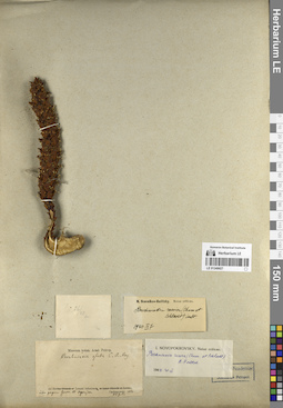
LE 01249927
Boschniakia rossica (Cham. & Schltdl.) B. Fedtsch. det. Ikonnikov-Galitzky, Nikolai Petrovic
Additional identifications: Boschniakia glabra C.A. Mey. ex Bong. det. Trautvetter, Rudolf Ernst von; Boschniakia rossica (Cham. & Schltdl.) B. Fedtsch. det. Novopokrovsky, Ivan Vassiljevich Collectors: Czekanowski, Alexander Piotr Collection date: 26.07.1875. Administrative regions: RU - Respublika Sakha (Yakutiya) - Bulunsky District. Groups of specimens: Образцы сектора Сибири и Дальнего Востока России; Соглашение Минобрнауки №075-15-2021-1056Original label text:Ad fl. Lenam inferiorem, inter pagum Gowor et Ogonjer
Coordinates (geographic position): 70° 32′ 47.63″ N, 126° 34′ 43.82″ E ±2000 mComment: Координаты приблизительны - согласно дневнику, Огоньёр находится между устьями рр. Крестях и Булун (левый берег Лены)
Record creation: 2023-09-13, Marina Yarichina, PhotoScan D2.Citation: Specimen LE 01249927 // Virtual herbarium of Komarov Botanical Institute RAS — http://re.herbariumle.ru/01249927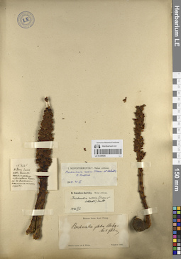
LE 01249926
Boschniakia rossica (Cham. & Schltdl.) B. Fedtsch. det. Ikonnikov-Galitzky, Nikolai Petrovic
Additional identifications: Boschniakia glabra C.A. Mey. ex Bong. det. Glehn, Peter von.; Boschniakia rossica (Cham. & Schltdl.) B. Fedtsch. det. Novopokrovsky, Ivan Vassiljevich Collectors: Poljakow, Ivan Semyonovich Collection date: 1866. Groups of specimens: Образцы сектора Сибири и Дальнего Востока России; Соглашение Минобрнауки №075-15-2021-1056Original label text:Sibiria orient. ad fl. Witim
Record creation: 2023-09-13, Marina Yarichina, PhotoScan D2.Citation: Specimen LE 01249926 // Virtual herbarium of Komarov Botanical Institute RAS — http://re.herbariumle.ru/01249926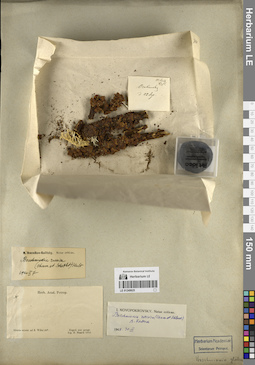
LE 01249925
Boschniakia rossica (Cham. & Schltdl.) B. Fedtsch. det. Ikonnikov-Galitzky, Nikolai Petrovic
Additional identifications: Boschniakia rossica (Cham. & Schltdl.) B. Fedtsch. det. Novopokrovsky, Ivan Vassiljevich Collectors: Maack, Richard Otto Collection date: 1854. Administrative regions: RU - Respublika Sakha (Yakutiya) - Vilyuysky District. Groups of specimens: Образцы сектора Сибири и Дальнего Востока России; Соглашение Минобрнауки №075-15-2021-1056Original label text:Sibiria orient. ad fl. Wilui 64°
Record creation: 2023-09-13, Marina Yarichina, PhotoScan D2.Citation: Specimen LE 01249925 // Virtual herbarium of Komarov Botanical Institute RAS — http://re.herbariumle.ru/01249925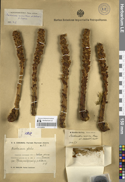
LE 01249924
Boschniakia rossica (Cham. & Schltdl.) B. Fedtsch. det. Ikonnikov-Galitzky, Nikolai Petrovic
Additional identifications: Boschniakia rossica (Cham. & Schltdl.) B. Fedtsch. det. Novopokrovsky, Ivan Vassiljevich Collectors: Sokolov, Ph.V. Administrative regions: RU - Respublika Sakha (Yakutiya) - Aldanskiy Rayon. Groups of specimens: Образцы сектора Сибири и Дальнего Востока России; Соглашение Минобрнауки №075-15-2021-1056Record creation: 2023-09-13, Marina Yarichina, PhotoScan D2.Citation: Specimen LE 01249924 // Virtual herbarium of Komarov Botanical Institute RAS — http://re.herbariumle.ru/01249924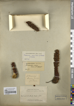
LE 01249923
Boschniakia rossica (Cham. & Schltdl.) B. Fedtsch. det. Ikonnikov-Galitzky, Nikolai Petrovic
Additional identifications: Boschniakia glabra C.A. Mey. ex Bong. det. Trautvetter, Rudolf Ernst von; Boschniakia rossica (Cham. & Schltdl.) B. Fedtsch. det. Novopokrovsky, Ivan Vassiljevich Collectors: Czekanowski, Alexander Piotr; Müller (Mueller), Ferdinand Ferdinandovich Collection date: 15.07.1874. Administrative regions: RU - Respublika Sakha (Yakutiya) - Olenyoksky District. Топоним: Средняя Майгда (река Чоной-Майындата). Groups of specimens: Образцы сектора Сибири и Дальнего Востока России; Соглашение Минобрнауки №075-15-2021-1056Original label text:Лесистый склон Олены, 15 июля
Sibiria orientalis ad fl. Olenek. Hand procul ab ostia Maigda media.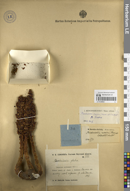
LE 01249922
Boschniakia rossica (Cham. & Schltdl.) B. Fedtsch. det. Ikonnikov-Galitzky, Nikolai Petrovic
Additional identifications: Boschniakia rossica (Cham. & Schltdl.) B. Fedtsch. det. Novopokrovsky, Ivan Vassiljevich Collectors: Sokolov, Ph.V. Administrative regions: RU - Respublika Sakha (Yakutiya) - Aldanskiy Rayon. Groups of specimens: Образцы сектора Сибири и Дальнего Востока России; Соглашение Минобрнауки №075-15-2021-1056Record creation: 2023-09-13, Marina Yarichina, PhotoScan D2.Citation: Specimen LE 01249922 // Virtual herbarium of Komarov Botanical Institute RAS — http://re.herbariumle.ru/01249922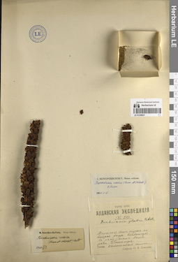
LE 01249921
Boschniakia rossica (Cham. & Schltdl.) B. Fedtsch. det. Ikonnikov-Galitzky, Nikolai Petrovic
Additional identifications: Boschniakia glabra C.A. Mey. ex Bong.; Boschniakia rossica (Cham. & Schltdl.) B. Fedtsch. det. Novopokrovsky, Ivan Vassiljevich Collectors: Sokolov, Ph.V. Administrative regions: RU - Respublika Sakha (Yakutiya). Subregion: Нерюнгринский район. Groups of specimens: Образцы сектора Сибири и Дальнего Востока России; Соглашение Минобрнауки №075-15-2021-1056Record creation: 2023-09-13, Marina Yarichina, PhotoScan D2.Citation: Specimen LE 01249921 // Virtual herbarium of Komarov Botanical Institute RAS — http://re.herbariumle.ru/01249921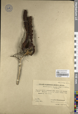
LE 01249920
Boschniakia rossica (Cham. & Schltdl.) B. Fedtsch. det. Kildyushevsky, Igor D.
Collectors: Kildyushevsky, Igor D. Administrative regions: RU - Respublika Sakha (Yakutiya). Subregion: Мирнинский район. Groups of specimens: Образцы сектора Сибири и Дальнего Востока России; Соглашение Минобрнауки №075-15-2021-1056Record creation: 2023-09-13, Marina Yarichina, PhotoScan D2.Citation: Specimen LE 01249920 // Virtual herbarium of Komarov Botanical Institute RAS — http://re.herbariumle.ru/01249920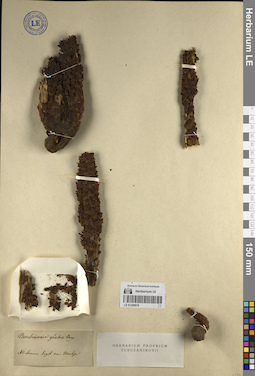
LE 01249919
Boschniakia rossica (Cham. & Schltdl.) B. Fedtsch.
Additional identifications: Boschniakia glabra C.A. Mey. ex Bong. det. Turczaninow, Nicolai Stepanowisch Collectors: Kruhse, Robert Administrative regions: RU - Irkutskaya Oblast' - Kachugskiy Rayon. Groups of specimens: Образцы сектора Сибири и Дальнего Востока России; Соглашение Минобрнауки №075-15-2021-1056Original label text:Ad Lenam
Comment: Скорее всего, образец собран верхнем течении Лены - в Иркутской губернии, а не в Якутии.
Record creation: 2023-09-13, Marina Yarichina, PhotoScan D2.Citation: Specimen LE 01249919 // Virtual herbarium of Komarov Botanical Institute RAS — http://re.herbariumle.ru/01249919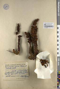
LE 01249918
Boschniakia rossica (Cham. & Schltdl.) B. Fedtsch.
Collectors: Lukitscheva, A.N.; Samarina, G. D. Administrative regions: RU - Respublika Sakha (Yakutiya) - Olenyoksky District. Groups of specimens: Образцы сектора Сибири и Дальнего Востока России; Соглашение Минобрнауки №075-15-2021-1056Record creation: 2023-09-13, Marina Yarichina, PhotoScan D2.Citation: Specimen LE 01249918 // Virtual herbarium of Komarov Botanical Institute RAS — http://re.herbariumle.ru/01249918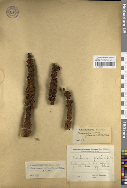
LE 01249917
Boschniakia rossica (Cham. & Schltdl.) B. Fedtsch. det. Ikonnikov-Galitzky, Nikolai Petrovic
Additional identifications: Boschniakia rossica (Cham. & Schltdl.) B. Fedtsch. det. Novopokrovsky, Ivan Vassiljevich Collectors: Korzhevin, Wladimir Sergeevich Administrative regions: RU - Respublika Sakha (Yakutiya) - Bulunsky District. Groups of specimens: Образцы сектора Сибири и Дальнего Востока России; Соглашение Минобрнауки №075-15-2021-1056Record creation: 2023-09-13, Marina Yarichina, PhotoScan D2.Citation: Specimen LE 01249917 // Virtual herbarium of Komarov Botanical Institute RAS — http://re.herbariumle.ru/01249917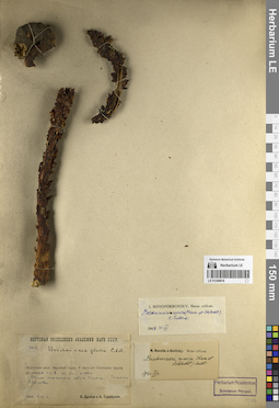
LE 01249916
Boschniakia rossica (Cham. & Schltdl.) B. Fedtsch. det. Ikonnikov-Galitzky, Nikolai Petrovic
Additional identifications: Boschniakia rossica (Cham. & Schltdl.) B. Fedtsch. det. Novopokrovsky, Ivan Vassiljevich Collectors: Drobow, Vasilii Petrovich; Tarabukin, A.P. Administrative regions: RU - Respublika Sakha (Yakutiya). Subregion: Томпонский район. Groups of specimens: Образцы сектора Сибири и Дальнего Востока России; Соглашение Минобрнауки №075-15-2021-1056Coordinates (geographic position): 62° 32′ 3.38″ N, 135° 4′ 29.94″ E ±1000 mRecord creation: 2023-09-13, Marina Yarichina, PhotoScan D2.Citation: Specimen LE 01249916 // Virtual herbarium of Komarov Botanical Institute RAS — http://re.herbariumle.ru/01249916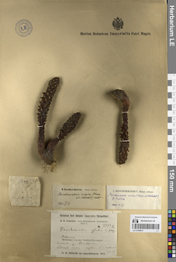
LE 01249915
Boschniakia rossica (Cham. & Schltdl.) B. Fedtsch. det. Novopokrovsky, Ivan Vassiljevich at 31.03.1948
Additional identifications: Boschniakia glabra C.A. Mey. ex Bong. det. Komarov, Vladimir Leontjevich; Boschniakia rossica (Cham. & Schltdl.) B. Fedtsch. det. Ikonnikov-Galitzky, Nikolai Petrovic at 07.09.1940 Collectors: Sokolov Th. V. Field collecting number: 1073bis. Collection date: 20.07.1912. Administrative regions: RU - Khabarovskiy Kray - Ayano-Mayskiy Rayon. Expedition: Ф.В. Соколов: Аяно-Нельканская Экспедиция 1912 г. (1912)Groups of specimens: Образцы сектора Сибири и Дальнего Востока России; Соглашение Минобрнауки №075-15-2021-1056Original label text:Якутская область, хребет Джугджур, истоки р. Ватома, подножье гольца перевала Оёмохит.
Record creation: 2023-09-13, Marina Yarichina, PhotoScan D2.Citation: Specimen LE 01249915 // Virtual herbarium of Komarov Botanical Institute RAS — http://re.herbariumle.ru/01249915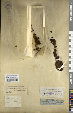
LE 01249914
Boschniakia rossica (Cham. & Schltdl.) B. Fedtsch. det. Ikonnikov-Galitzky, Nikolai Petrovic
Additional identifications: Boschniakia rossica (Cham. & Schltdl.) B. Fedtsch. det. Novopokrovsky, Ivan Vassiljevich Collection date: 10.07. Administrative regions: RU - Respublika Sakha (Yakutiya) - Suntarskiy District. Place of collection: р. Кемпендяй.Groups of specimens: Образцы сектора Сибири и Дальнего Востока России; Соглашение Минобрнауки №075-15-2021-1056Original label text:Am flus. Kempendei gegenuber des ... im Wilui...
Coordinates (geographic position): 62° 9′ 26.8″ N, 117° 43′ 2.89″ E ±2000 mRecord creation: 2023-09-13, Marina Yarichina, PhotoScan D2.Citation: Specimen LE 01249914 // Virtual herbarium of Komarov Botanical Institute RAS — http://re.herbariumle.ru/01249914Herb. Ledebour.
LE 01249913
Boschniakia rossica (Cham. & Schltdl.) B. Fedtsch. det. Ikonnikov-Galitzky, Nikolai Petrovic
Additional identifications: Boschniakia rossica (Cham. & Schltdl.) B. Fedtsch. det. Novopokrovsky, Ivan Vassiljevich Collectors: Sukaczev, Vladimir Nikolajevich; Poplavskaya (Poplawska), Henrietta Ippolitovna Administrative regions: RU - Zabaykal'skiy Kray - Tungiro-Olekminskiy Rayon. Groups of specimens: Образцы сектора Сибири и Дальнего Востока России; Соглашение Минобрнауки №075-15-2021-1056Coordinates (geographic position): 54° 26′ 11.04″ N, 119° 55′ 31.19″ E ±500 mRecord creation: 2023-09-13, Marina Yarichina, PhotoScan D2.Citation: Specimen LE 01249913 // Virtual herbarium of Komarov Botanical Institute RAS — http://re.herbariumle.ru/01249913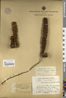
LE 01249912
Boschniakia rossica (Cham. & Schltdl.) B. Fedtsch. det. Ikonnikov-Galitzky, Nikolai Petrovic
Additional identifications: Boschniakia rossica (Cham. & Schltdl.) B. Fedtsch. det. Novopokrovsky, Ivan Vassiljevich Collectors: Drobow, Vasilii Petrovich Administrative regions: RU - Respublika Sakha (Yakutiya). Subregion: Амгинский улус. Groups of specimens: Образцы сектора Сибири и Дальнего Востока России; Соглашение Минобрнауки №075-15-2021-1056; Гербарий Переселенческого УправленияCoordinates (geographic position): 60° 52′ 54.72″ N, 132° 0′ 29.91″ E ±1000 mRecord creation: 2023-09-13, Marina Yarichina, PhotoScan D2.Citation: Specimen LE 01249912 // Virtual herbarium of Komarov Botanical Institute RAS — http://re.herbariumle.ru/01249912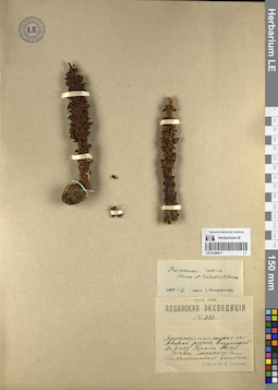
LE 01249911
Boschniakia rossica (Cham. & Schltdl.) B. Fedtsch. det. Novopokrovsky, Ivan Vassiljevich
Collectors: Sokolov, Ph.V. Administrative regions: RU - Respublika Sakha (Yakutiya). Subregion: Нерюнгринский район. Groups of specimens: Образцы сектора Сибири и Дальнего Востока России; Соглашение Минобрнауки №075-15-2021-1056Coordinates (geographic position): 56° 28′ 29.84″ N, 127° 6′ 42.84″ E ±2000 mRecord creation: 2023-09-13, Marina Yarichina, PhotoScan D2.Citation: Specimen LE 01249911 // Virtual herbarium of Komarov Botanical Institute RAS — http://re.herbariumle.ru/01249911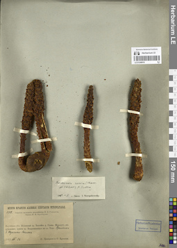
LE 01249910
Boschniakia rossica (Cham. & Schltdl.) B. Fedtsch. det. Novopokrovsky, Ivan Vassiljevich
Collectors: Prokhorov, Nikolay Ivanovich; Kuzeneva, Olga Iakinfovna Administrative regions: RU - Respublika Sakha (Yakutiya). Subregion: Нерюнгринский район. Groups of specimens: Образцы сектора Сибири и Дальнего Востока России; Соглашение Минобрнауки №075-15-2021-1056Coordinates (geographic position): 55° 47′ 59.87″ N, 130° 22′ 25.04″ E ±5000 mRecord creation: 2023-09-13, Marina Yarichina, PhotoScan D2.Citation: Specimen LE 01249910 // Virtual herbarium of Komarov Botanical Institute RAS — http://re.herbariumle.ru/01249910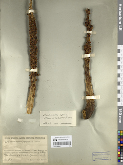
LE 01249909
Boschniakia rossica (Cham. & Schltdl.) B. Fedtsch. det. Novopokrovsky, Ivan Vassiljevich
Collectors: Prokhorov, Nikolay Ivanovich; Kuzeneva, Olga Iakinfovna Administrative regions: RU - Respublika Sakha (Yakutiya); RU - Khabarovskiy Kray - Ayano-Mayskiy Rayon. Subregion: Нерюнгринский район. Groups of specimens: Образцы сектора Сибири и Дальнего Востока России; Соглашение Минобрнауки №075-15-2021-1056Coordinates (geographic position): 56° 6′ 21.98″ N, 130° 58′ 22.03″ E ±500 mComment:По р. Мулам проходит граница Хабаровского края и Якутии
Record creation: 2023-09-13, Marina Yarichina, PhotoScan D2.Citation: Specimen LE 01249909 // Virtual herbarium of Komarov Botanical Institute RAS — http://re.herbariumle.ru/01249909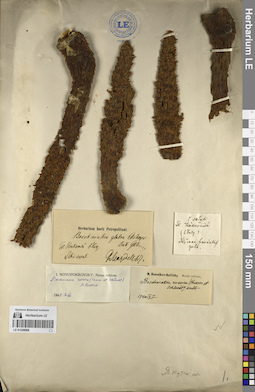
LE 01249908
Boschniakia rossica (Cham. & Schltdl.) B. Fedtsch. det. Ikonnikov-Galitzky, Nikolai Petrovic
Additional identifications: Boschniakia glabra C.A. Mey. ex Bong. det. Glehn, Peter von.; Boschniakia rossica (Cham. & Schltdl.) B. Fedtsch. det. Novopokrovsky, Ivan Vassiljevich Collectors: Maydell, Georg, Baron von Collection date: 06.07.1866. Administrative regions: RU - Respublika Sakha (Yakutiya). Groups of specimens: Образцы сектора Сибири и Дальнего Востока России; Соглашение Минобрнауки №075-15-2021-1056Original label text:Sibir. orient. Fl. Koskomda
Record creation: 2023-09-13, Marina Yarichina, PhotoScan D2.Citation: Specimen LE 01249908 // Virtual herbarium of Komarov Botanical Institute RAS — http://re.herbariumle.ru/01249908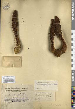
LE 01249907
Boschniakia rossica (Cham. & Schltdl.) B. Fedtsch. det. Ikonnikov-Galitzky, Nikolai Petrovic
Additional identifications: Boschniakia glabra C.A. Mey. ex Bong.; Boschniakia rossica (Cham. & Schltdl.) B. Fedtsch. det. Novopokrovsky, Ivan Vassiljevich Collectors: Savich, Natalia Mikhailovna Administrative regions: RU - Zabaykal'skiy Kray - Kalarskiy Rayon. Groups of specimens: Образцы сектора Сибири и Дальнего Востока России; Соглашение Минобрнауки №075-15-2021-1056Coordinates (geographic position): 55° 57′ 40.82″ N, 117° 25′ 50.62″ E ±2000 mRecord creation: 2023-09-13, Marina Yarichina, PhotoScan D2.Citation: Specimen LE 01249907 // Virtual herbarium of Komarov Botanical Institute RAS — http://re.herbariumle.ru/01249907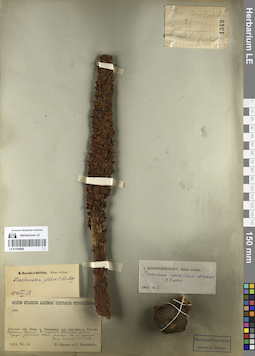
LE 01249906
Boschniakia rossica (Cham. & Schltdl.) B. Fedtsch. det. Novopokrovsky, Ivan Vassiljevich
Additional identifications: Boschniakia glabra C.A. Mey. ex Bong. det. Ikonnikov-Galitzky, Nikolai Petrovic Collectors: Sukaczev, Vladimir Nikolajevich; Poplavskaya (Poplawska), Henrietta Ippolitovna Administrative regions: RU - Zabaykal'skiy Kray - Tungiro-Olekminskiy Rayon. Groups of specimens: Образцы сектора Сибири и Дальнего Востока России; Соглашение Минобрнауки №075-15-2021-1056Record creation: 2023-09-13, Marina Yarichina, PhotoScan D2.Citation: Specimen LE 01249906 // Virtual herbarium of Komarov Botanical Institute RAS — http://re.herbariumle.ru/01249906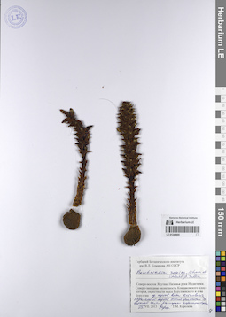
LE 01249905
Boschniakia rossica (Cham. & Schltdl.) B. Fedtsch. det. Koroleva (Zaslavskaya), Tatiana
Collectors: Koroleva (Zaslavskaya), Tatiana Administrative regions: RU - Respublika Sakha (Yakutiya). Subregion: Аллаиховский улус. Groups of specimens: Образцы сектора Сибири и Дальнего Востока России; Соглашение Минобрнауки №075-15-2021-1056Coordinates (geographic position): 70° 45′ 4.5″ N, 148° 41′ 17.77″ E ±1000 mRecord creation: 2023-09-13, Marina Yarichina, PhotoScan D2.Citation: Specimen LE 01249905 // Virtual herbarium of Komarov Botanical Institute RAS — http://re.herbariumle.ru/01249905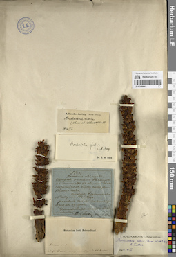
LE 01249904
Boschniakia rossica (Cham. & Schltdl.) B. Fedtsch. det. Ikonnikov-Galitzky, Nikolai Petrovic
Additional identifications: Boschniakia rossica (Cham. & Schltdl.) B. Fedtsch. det. Novopokrovsky, Ivan Vassiljevich Collectors: Sharypov Collection date: 16.08.1827. Administrative regions: RU - Respublika Sakha (Yakutiya) - Nizhnekolymskiy Rayon. Place of collection: Долина р. Большой Анюй.Groups of specimens: Образцы сектора Сибири и Дальнего Востока России; Соглашение Минобрнауки №075-15-2021-1056Original label text:Растение из трав. Растет на островах в ... земле... на западном берегу...
Record creation: 2023-09-13, Marina Yarichina, PhotoScan D2.Citation: Specimen LE 01249904 // Virtual herbarium of Komarov Botanical Institute RAS — http://re.herbariumle.ru/01249904Ad fl. Anuj magnum 1827 Ex herb. Fischer [Maximowicz]
LE 01249903
Boschniakia rossica (Cham. & Schltdl.) B. Fedtsch. det. Ikonnikov-Galitzky, Nikolai Petrovic
Additional identifications: Boschniakia rossica (Cham. & Schltdl.) B. Fedtsch. det. Novopokrovsky, Ivan Vassiljevich Collectors: Shulga, Ivan Aleksandrovich Administrative regions: RU - Respublika Sakha (Yakutiya) - Srednekolymsky District. Expedition: С. А. Бутурлин: Колымская экспедиция 1905 г. (01.1905 -11.1905)Groups of specimens: Образцы сектора Сибири и Дальнего Востока России; Соглашение Минобрнауки №075-15-2021-1056Record creation: 2023-09-13, Marina Yarichina, PhotoScan D2.Citation: Specimen LE 01249903 // Virtual herbarium of Komarov Botanical Institute RAS — http://re.herbariumle.ru/01249903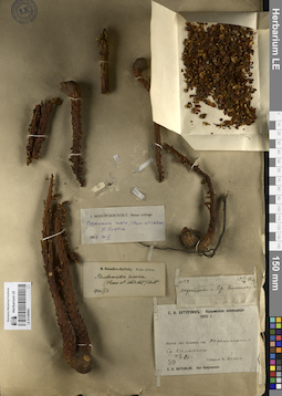
LE 01249902
Boschniakia rossica (Cham. & Schltdl.) B. Fedtsch. det. Ikonnikov-Galitzky, Nikolai Petrovic
Additional identifications: Boschniakia rossica (Cham. & Schltdl.) B. Fedtsch. det. Novopokrovsky, Ivan Vassiljevich Collectors: Shulga, Ivan Aleksandrovich Administrative regions: RU - Respublika Sakha (Yakutiya) - Srednekolymsky District. Expedition: С. А. Бутурлин: Колымская экспедиция 1905 г. (01.1905 -11.1905)Groups of specimens: Образцы сектора Сибири и Дальнего Востока России; Соглашение Минобрнауки №075-15-2021-1056Record creation: 2023-09-13, Marina Yarichina, PhotoScan D2.Citation: Specimen LE 01249902 // Virtual herbarium of Komarov Botanical Institute RAS — http://re.herbariumle.ru/01249902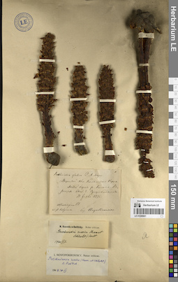
LE 01249901
Boschniakia rossica (Cham. & Schltdl.) B. Fedtsch. det. Ikonnikov-Galitzky, Nikolai Petrovic
Additional identifications: Boschniakia glabra C.A. Mey. ex Bong. det. Augustinowicz, Foma Matveevich; Boschniakia rossica (Cham. & Schltdl.) B. Fedtsch. det. Novopokrovsky, Ivan Vassiljevich Collectors: Augustinowicz, Foma Matveevich Collection date: 31.07.1875. Administrative regions: RU - Respublika Sakha (Yakutiya) - Srednekolymsky District. Groups of specimens: Образцы сектора Сибири и Дальнего Востока России; Соглашение Минобрнауки №075-15-2021-1056Original label text:Якутской области Колымского округа, левый берег р. Колымы, в рощах близ г. Средне Колымска.
Coordinates (geographic position): 67° 27′ 57.46″ N, 153° 41′ 36.35″ E ±1000 mRecord creation: 2023-09-13, Marina Yarichina, PhotoScan D2.Citation: Specimen LE 01249901 // Virtual herbarium of Komarov Botanical Institute RAS — http://re.herbariumle.ru/01249901Ad fl. Kolyma
LE 01249900
Boschniakia rossica (Cham. & Schltdl.) B. Fedtsch. det. Ikonnikov-Galitzky, Nikolai Petrovic
Additional identifications: Boschniakia glabra C.A. Mey. ex Bong. det. Trautvetter, Rudolf Ernst von; Boschniakia rossica (Cham. & Schltdl.) B. Fedtsch. det. Novopokrovsky, Ivan Vassiljevich Collectors: Augustinowicz, Foma Matveevich Field collecting number: 1044. Collection date: 31.07.1875. Administrative regions: RU - Respublika Sakha (Yakutiya) - Srednekolymsky District. Groups of specimens: Образцы сектора Сибири и Дальнего Востока России; Соглашение Минобрнауки №075-15-2021-1056Original label text:Territorii Jacutensis districtum Kolymensis, in ripa sinistra fl. Kolymensis, prope oppidum Ssredne-Kolymsk, in nemoribus, in radicibus Alni sibiricae.
Coordinates (geographic position): 67° 27′ 45.84″ N, 153° 41′ 22.63″ E ±1000 mRecord creation: 2023-09-13, Marina Yarichina, PhotoScan D2.Citation: Specimen LE 01249900 // Virtual herbarium of Komarov Botanical Institute RAS — http://re.herbariumle.ru/01249900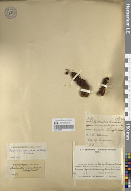
LE 01249899
Boschniakia rossica (Cham. & Schltdl.) B. Fedtsch. det. Ikonnikov-Galitzky, Nikolai Petrovic
Additional identifications: Boschniakia rossica (Cham. & Schltdl.) B. Fedtsch. det. Novopokrovsky, Ivan Vassiljevich Administrative regions: RU - Respublika Sakha (Yakutiya) - Srednekolymsky District. Expedition: С. А. Бутурлин: Колымская экспедиция 1905 г. (01.1905 -11.1905)Groups of specimens: Образцы сектора Сибири и Дальнего Востока России; Соглашение Минобрнауки №075-15-2021-1056Coordinates (geographic position): 67° 27′ 59.94″ N, 153° 41′ 24.66″ E ±500 mRecord creation: 2023-09-13, Marina Yarichina, PhotoScan D2.Citation: Specimen LE 01249899 // Virtual herbarium of Komarov Botanical Institute RAS — http://re.herbariumle.ru/01249899