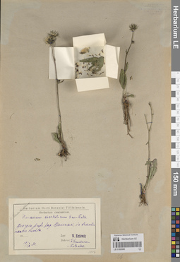
View
Add
Copy
Edit
Delete
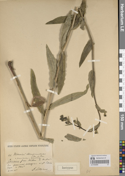
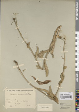
LE 01262687
Groups of specimens: Образцы сектора Кавказа; Типовые образцы сектора Кавказа; Соглашение Минобрнауки №075-15-2021-1056Record creation: 2023-11-22, Elena Portenier, PhotoScan D2.Citation: Specimen LE 01262687 // Virtual herbarium of Komarov Botanical Institute RAS — http://re.herbariumle.ru/01262687
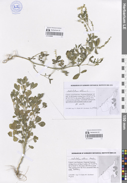
LE 01262686
Groups of specimens: Образцы сектора Кавказа; Типовые образцы сектора Кавказа; Соглашение Минобрнауки №075-15-2021-1056Record creation: 2023-11-22, Elena Portenier, PhotoScan D2.Citation: Specimen LE 01262686 // Virtual herbarium of Komarov Botanical Institute RAS — http://re.herbariumle.ru/01262686
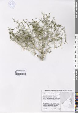
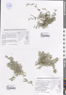
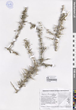
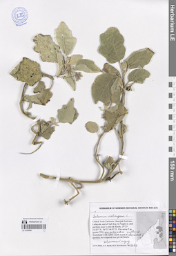
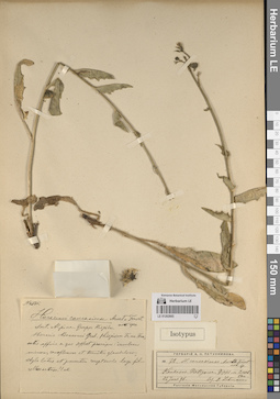
LE 01259710
Fagonia indica Burm. f. det. Byalt, Vyacheslav Vyacheslavovich
Collectors: Byalt, Vyacheslav Vyacheslavovich Field collecting number: 498. Collection date: 31.03.2017. Administrative regions: AE - United Arab Emirates. Place of collection: Шаржа, глубокое ущелье на границе с Фуджейрой: каменисто-щебнистый склон.Groups of specimens: Образцы общего сектора; Соглашение Минобрнауки №075-15-2021-1056; Бялт В.В.: Флора ФуджейрыOriginal label text: United Arab Emirates. Emirate of Sharjah, 25°22, 997’ N, 56° 01, 211’ E, 470 m alt., gorge on borders with Fujaira: on stony-gravelly slope.– ОАЭ, Шаржа, 25°22, 997’ N, 56° 01, 211’ E, 470 м выс., глубокое ущелье на границе с Фуджейрой: на каменисто-щебнистом склоне, 31 III 2017, fl., V.V. Byalt 498
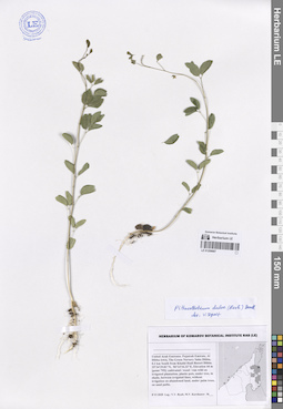
LE 01262685
Groups of specimens: Образцы сектора Кавказа; Типовые образцы сектора Кавказа; Соглашение Минобрнауки №075-15-2021-1056Record creation: 2023-11-22, Elena Portenier, PhotoScan D2.Citation: Specimen LE 01262685 // Virtual herbarium of Komarov Botanical Institute RAS — http://re.herbariumle.ru/01262685
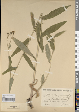
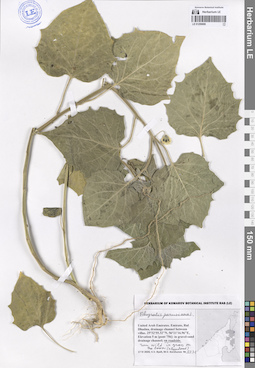
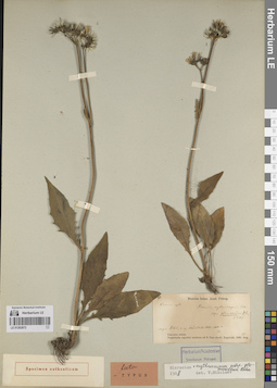
LE 01259708
Tribulus parvispinus C. Presl det. Byalt, Vyacheslav Vyacheslavovich
Collectors: Byalt, Vyacheslav Vyacheslavovich Field collecting number: 191. Collection date: 25.03.2017. Administrative regions: AE - United Arab Emirates. Place of collection: Фуджейра, Вади Вурайа Национальный парк, в 8 км северо-западнее г. Хор Факкан, выше вади: малый боковой вади.Groups of specimens: Образцы общего сектора; Соглашение Минобрнауки №075-15-2021-1056; Бялт В.В.: Флора ФуджейрыOriginal label text: United Arab Emirates. Emirate of Fujaira, Wadi Wurayah National Park, 8 km NW from Khor Fakkan, 25°23, 366’ N, 56° 18, 356’ E, upper wadi: in small lateral wadi.– ОАЭ, Фуджейра, Вади Вурайа Национальный парк, в 8 км к СЗ от г. Хор Факкан, 25°23, 366’ N, 56° 18, 356’ E, выше вади: малый боковой вади, 25 III 2017, fl., fr., V.V. Byalt 191

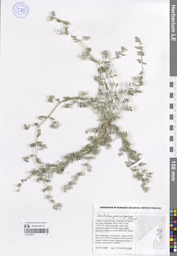
LE 01259709
Tribulus parvispinus C. Presl det. Byalt, Vyacheslav Vyacheslavovich
Collectors: Byalt, Vyacheslav Vyacheslavovich Field collecting number: 445. Collection date: 29.03.2017. Administrative regions: AE - United Arab Emirates. Place of collection: Фуджейра, вади в окрестности г. Мазафи, отрог вади с ручьем, на тропе.Groups of specimens: Образцы общего сектора; Соглашение Минобрнауки №075-15-2021-1056; Бялт В.В.: Флора ФуджейрыOriginal label text: United Arab Emirates. Emirate of Fujaira, wadi in environs of Masafi, 25°20, 017’ N, 56° 11, 847’ E, 540–600 m alt.: confluence of wadi with water, on pathside.– ОАЭ, Фуджейра, вади в окрестности г. Мазафи, 25°20, 017’ N, 56° 11, 847’ E, 540–600 м н. ур. м.: отрог вади с ручьем, на тропе, 29 III 2017, fl., fr., V.V. Byalt 445
LE 01262684
Groups of specimens: Образцы сектора Кавказа; Типовые образцы сектора Кавказа; Соглашение Минобрнауки №075-15-2021-1056Record creation: 2023-11-22, Elena Portenier, PhotoScan D2.Citation: Specimen LE 01262684 // Virtual herbarium of Komarov Botanical Institute RAS — http://re.herbariumle.ru/01262684
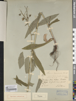
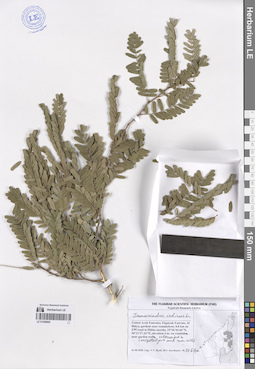
LE 01259707
Tribulus parvispinus C. Presl det. Byalt, Vyacheslav Vyacheslavovich
Collectors: Byalt, Vyacheslav Vyacheslavovich Field collecting number: 278. Collection date: 26.03.2017. Administrative regions: AE - United Arab Emirates. Place of collection: Фуджейра, окрестности г. Дадна, широкая горная долина и горные склоны: каменистые поля.Groups of specimens: Образцы общего сектора; Соглашение Минобрнауки №075-15-2021-1056; Бялт В.В.: Флора ФуджейрыOriginal label text: United Arab Emirates. Emirate of Fujaira, environs of Dadna, 25°24, 018’ N, 56° 17,475’ E: wide mountain valley and mountain slopes: on stony fields between wadies. – ОАЭ, Фуджейра, окрестности г. Дадна, 25°24, 018’ N, 56° 17,475’ E: широкая горная долина и горные склоны: каменистые поля, 26–27 III 2017, fl., fr., V.V. Byalt 278
LE 01262683
Groups of specimens: Образцы сектора Кавказа; Типовые образцы сектора Кавказа; Соглашение Минобрнауки №075-15-2021-1056Record creation: 2023-11-22, Elena Portenier, PhotoScan D2.Citation: Specimen LE 01262683 // Virtual herbarium of Komarov Botanical Institute RAS — http://re.herbariumle.ru/01262683
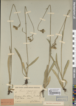
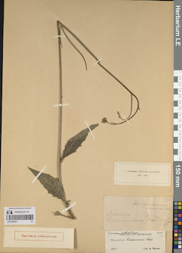
LE 01259706
Viola cinerea Boiss. det. Byalt, Vyacheslav Vyacheslavovich
Collectors: Byalt, Vyacheslav Vyacheslavovich; Korshunov, Mikhail Vladimirovich Field collecting number: s.n. Collection date: 28.03.2020. Place of collection: Oman enclave Madha, 1 km to border with Fujairah Emirate, 6 km East from Nahwa (Sharjah Emirate), or 5 km North from Bitnah (Fujairah Emirate) [point 722]: on montain side.Groups of specimens: Образцы общего сектора; Соглашение Минобрнауки №075-15-2021-1056; Бялт В.В.: Флора ФуджейрыOriginal label text: Oman enclave Madha, 1 km to border with Fujairah Emirate, 6 km East from Nahwa (Sharjah Emirate), or 5 km North from Bitnah (Fujairah Emirate). 25°15'29.80"N, 56°13'32.22"E, elevation 455 m [point 722]: on montain side, 28 III 2020, V.V. Byalt, M.V. Korshunov s.n.
LE 01262682
Groups of specimens: Образцы сектора Кавказа; Типовые образцы сектора Кавказа; Соглашение Минобрнауки №075-15-2021-1056Record creation: 2023-11-22, Elena Portenier, PhotoScan D2.Citation: Specimen LE 01262682 // Virtual herbarium of Komarov Botanical Institute RAS — http://re.herbariumle.ru/01262682
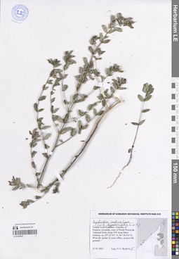
LE 01259705
Euphorbia indica Lam. ⟮s. str.⟯ det. Byalt, Vyacheslav Vyacheslavovich
Additional identifications: Euphorbia hypericifolia L. ⟮s. l.⟯ det. Byalt, Vyacheslav Vyacheslavovich Collectors: Byalt, Vyacheslav Vyacheslavovich Field collecting number: 5. Collection date: 13.04.2022. Administrative regions: AE - United Arab Emirates. Place of collection: Emirate of Fujaira, carantine zone of Wadi Wurayah National Park, 8 km NW from Khor Fakkan, near office, on gravelly ground.Groups of specimens: Образцы общего сектора; Соглашение Минобрнауки №075-15-2021-1056; Бялт В.В.: Флора ФуджейрыOriginal label text: United Arab Emirates. Emirate of Fujaira, carantine zone of Wadi Wurayah National Park, 8 km NW from Khor Fakkan, ca. 25° 23.767' N, 56° 18.314' E, 90 m alt., near office, on gravelly ground, 13 IV 2022, fl., V.V. Byalt 5
LE 01262681
Groups of specimens: Образцы сектора Кавказа; Типовые образцы сектора Кавказа; Соглашение Минобрнауки №075-15-2021-1056Record creation: 2023-11-22, Elena Portenier, PhotoScan D2.Citation: Specimen LE 01262681 // Virtual herbarium of Komarov Botanical Institute RAS — http://re.herbariumle.ru/01262681
LE 01259704
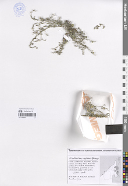
Andrachne aspera Spreng. det. Byalt, Vyacheslav Vyacheslavovich
Collectors: Byalt, Vyacheslav Vyacheslavovich; Korshunov, Mikhail Vladimirovich Field collecting number: s.n. Collection date: 30.03.2020. Administrative regions: AE - United Arab Emirates. Place of collection: Fujairah Emirate, near village Bithna. Wadi with gardens [point 724]: wadi banks, under rock.Groups of specimens: Образцы общего сектора; Соглашение Минобрнауки №075-15-2021-1056; Herbarium of Wadi Wurayah Department, Goverment of FujairahOriginal label text: UAE, Fujairah Emirate, near village Bithna. Wadi with gardens. 25°11'19.00"N, 56°14'15.97"E, elevation 170 m. [point 724]: wadi banks, under rock, 30 III 2020, fl., fr., V.V. Byalt, M.V. Korshunov s.n.
LE 01262680
Groups of specimens: Образцы сектора Кавказа; Типовые образцы сектора Кавказа; Соглашение Минобрнауки №075-15-2021-1056Record creation: 2023-11-22, Elena Portenier, PhotoScan D2.Citation: Specimen LE 01262680 // Virtual herbarium of Komarov Botanical Institute RAS — http://re.herbariumle.ru/01262680
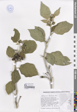
LE 01259703
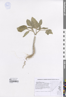
Solanum melongena L. det. Byalt, Vyacheslav Vyacheslavovich
Additional identifications: Heliotropium sp. det. Byalt, Vyacheslav Vyacheslavovich Collectors: Byalt, Vyacheslav Vyacheslavovich; Korshunov, Mikhail Vladimirovich Field collecting number: s.n. Collection date: 01.04.2020. Administrative regions: AE - United Arab Emirates. Place of collection: Fujairah Emirate, Al Siji, wadi Siji, road-damb 1 km East from Wadi Siji Old Dam [point 729]: left bank of sand wadi with pond.Groups of specimens: Образцы общего сектора; Соглашение Минобрнауки №075-15-2021-1056; Бялт В.В.: Флора ФуджейрыOriginal label text: UAE, Fujairah Emirate, Al Siji, wadi Siji, road-damb 1 km East from Wadi Siji Old Dam, 25°15'7.86"N, 56° 5'15.17"E, elevation 286 m. [point 729]: left bank of sand wadi with pond, 1 IV 2020, veg., V.V. Byalt, M.V. Korshunov s.n.
LE 01262679
Groups of specimens: Образцы сектора Кавказа; Типовые образцы сектора Кавказа; Соглашение Минобрнауки №075-15-2021-1056Record creation: 2023-11-22, Elena Portenier, PhotoScan D2.Citation: Specimen LE 01262679 // Virtual herbarium of Komarov Botanical Institute RAS — http://re.herbariumle.ru/01262679
LE 01259702
Oldenlandia corymbosa L. det. Byalt, Vyacheslav Vyacheslavovich
Collectors: Byalt, Vyacheslav Vyacheslavovich; Korshunov, Mikhail Vladimirovich Field collecting number: s.n. Collection date: 25.11.2019. Administrative regions: AE - United Arab Emirates. Place of collection: Фуджейра, пос. Кидфа [point 343]: обочина дороги вдоль заборов в переулке.Groups of specimens: Образцы общего сектора; Соглашение Минобрнауки №075-15-2021-1056; Бялт В.В.: Флора ФуджейрыOriginal label text: United Arab Emirates. Emirate of Fujaira, village Qidfa, 25°17'40.91"N 56°21'28.51"E [point 343]: roadside along fence in backstreet. – ОАЭ, Фуджейра, пос. Кидфа, 25°17'40.91"N 56°21'28.51"E [point 343]: обочина дороги вдоль заборов в переулке, 25 XI 2019 V.V. Byalt & M.V. Korshunov s. n.
LE 01262678
Groups of specimens: Образцы сектора Кавказа; Типовые образцы сектора Кавказа; Соглашение Минобрнауки №075-15-2021-1056Record creation: 2023-11-22, Elena Portenier, PhotoScan D2.Citation: Specimen LE 01262678 // Virtual herbarium of Komarov Botanical Institute RAS — http://re.herbariumle.ru/01262678
LE 01259701
Solanum virginianum L. det. Byalt, Vyacheslav Vyacheslavovich
Additional identifications: Solanum surattense Burm. f. det. Byalt, Vyacheslav Vyacheslavovich Collectors: Byalt, Vyacheslav Vyacheslavovich; Korshunov, Mikhail Vladimirovich Field collecting number: s.n. Collection date: 17.04.2020. Administrative regions: AE - United Arab Emirates. Place of collection: Fujairah Emirate, Rul Dhadna, villas and accommodations north from Mina road, on corner with E99 Rugaylat road [pont 755]: weed in dranaige.Groups of specimens: Образцы общего сектора; Соглашение Минобрнауки №075-15-2021-1056; Бялт В.В.: Флора ФуджейрыOriginal label text: United Arab Emirates. Fujairah Emirate, Rul Dhadna, villas and accommodations north from Mina road, on corner with E99 Rugaylat road. 25°31'16.29"N, 56°21'19.69"E, elevation 12 m [pont 755]: weed in dranaige, 17 IV 2020, V.V. Byalt, M.V. Korshunov s.n
LE 01262677
Groups of specimens: Образцы сектора Кавказа; Типовые образцы сектора Кавказа; Соглашение Минобрнауки №075-15-2021-1056Record creation: 2023-11-22, Elena Portenier, PhotoScan D2.Citation: Specimen LE 01262677 // Virtual herbarium of Komarov Botanical Institute RAS — http://re.herbariumle.ru/01262677
LE 01259700
Solanum torvum Sw. det. Byalt, Vyacheslav Vyacheslavovich
Collectors: Byalt, Vyacheslav Vyacheslavovich; Korshunov, Mikhail Vladimirovich Field collecting number: 2216. Collection date: 17.04.2020. Administrative regions: AE - United Arab Emirates. Place of collection: Fujairah Emirate, Rul Dhadna, villas and accommodations north from Mina road, on corner with E99 Rugaylat road [pont 755]: cultivated near gates of villa.Groups of specimens: Образцы общего сектора; Соглашение Минобрнауки №075-15-2021-1056; Бялт В.В.: Флора ФуджейрыObject features: Fl. whiteOriginal label text: United Arab Emirates. Fujairah Emirate, Rul Dhadna, villas and accommodations north from Mina road, on corner with E99 Rugaylat road. 25°31'16.29"N, 56°21'19.69"E, Elevation 12 m [pont 755]: cultivated near gates of villa. h. fl. white., 17 IV 2020, fl., fr., V.V. Byalt, M.V. Korshunov 2216
LE 01262676
Groups of specimens: Образцы сектора Кавказа; Типовые образцы сектора Кавказа; Соглашение Минобрнауки №075-15-2021-1056Record creation: 2023-11-22, Elena Portenier, PhotoScan D2.Citation: Specimen LE 01262676 // Virtual herbarium of Komarov Botanical Institute RAS — http://re.herbariumle.ru/01262676
LE 01259699
Solanum peruvianum L. det. Byalt, Vyacheslav Vyacheslavovich
Collectors: Byalt, Vyacheslav Vyacheslavovich; Korshunov, Mikhail Vladimirovich Field collecting number: 2231. Collection date: 17.04.2020. Administrative regions: AE - United Arab Emirates. Place of collection: Fujairah Emirate, Rul Dhadna, drainage channel between villas [pont 756]: run wild in grass on the lawn (abandoned) on roadside.Groups of specimens: Образцы общего сектора; Соглашение Минобрнауки №075-15-2021-1056; Бялт В.В.: Флора ФуджейрыOriginal label text: United Arab Emirates. Fujairah Emirate, Rul Dhadna, drainage channel between villas. 25°32'55.32"N, 56°21'16.96"E, elevation 5 m [pont 756]: run wild in grass on the lawn (abandoned) on roadside, 17 IV 2020, V.V. Byalt, M.V. Korshunov 2231
LE 01262675
Groups of specimens: Образцы сектора Кавказа; Типовые образцы сектора Кавказа; Соглашение Минобрнауки №075-15-2021-1056Record creation: 2023-11-22, Elena Portenier, PhotoScan D2.Citation: Specimen LE 01262675 // Virtual herbarium of Komarov Botanical Institute RAS — http://re.herbariumle.ru/01262675
LE 01259698
Lycium shawii Roem. & Schult. det. Byalt, Vyacheslav Vyacheslavovich
Collectors: Byalt, Vyacheslav Vyacheslavovich; Korshunov, Mikhail Vladimirovich Field collecting number: 413. Collection date: 13.03.2020. Administrative regions: AE - United Arab Emirates. Place of collection: Fujairah Emirate, Al Tawyeen (Taween) area, 2.4 km West-South-West to mountain peak, abandoned baghara (winter season dryland farm) [point 708]: in sand on dryland field.Groups of specimens: Образцы общего сектора; Соглашение Минобрнауки №075-15-2021-1056; Бялт В.В.: Флора ФуджейрыOriginal label text: United Arab Emirates, Fujairah Emirate, Al Tawyeen (Taween) area, 2.4 km West-South-West to mountain peak, abandoned baghara (winter season dryland farm). 25°37'42.66"N, 56° 7'19.59"E, elevation 950 m. [point 708]: in sand on dryland field, 13 III 2020, V.V. Byalt, M.V. Korshunov 413
LE 01262674
Groups of specimens: Образцы сектора Кавказа; Типовые образцы сектора Кавказа; Соглашение Минобрнауки №075-15-2021-1056Record creation: 2023-11-22, Elena Portenier, PhotoScan D2.Citation: Specimen LE 01262674 // Virtual herbarium of Komarov Botanical Institute RAS — http://re.herbariumle.ru/01262674
LE 01259697
Nicotiana plumbaginifolia Viv. det. Byalt, Vyacheslav Vyacheslavovich
Collectors: Byalt, Vyacheslav Vyacheslavovich; Korshunov, Mikhail Vladimirovich Field collecting number: s.n. Collection date: 19.05.2020. Administrative regions: AE - United Arab Emirates. Place of collection: Fujairah Emirate, Al Bidiya, Al Qalamoon Nursery, 0.3 km East from Eid Prayer Ground Bidyah [point 781]: weed without irrigation on abandoned land.Groups of specimens: Образцы общего сектора; Соглашение Минобрнауки №075-15-2021-1056; Бялт В.В.: Флора ФуджейрыOriginal label text: United Arab Emirates. Fujairah Emirate, Al Bidiya, Al Qalamoon Nursery, 0.3 km East from Eid Prayer Ground Bidyah, 25°25' 24.70" N, 56°20'18.77"E, Elevation 22 m [point 781]: weed without irrigation on abandoned land, 19 V 2020, V.V. Byalt, M.V. Korshunov s.n
LE 01262673
Groups of specimens: Образцы сектора Кавказа; Типовые образцы сектора Кавказа; Соглашение Минобрнауки №075-15-2021-1056Record creation: 2023-11-22, Elena Portenier, PhotoScan D2.Citation: Specimen LE 01262673 // Virtual herbarium of Komarov Botanical Institute RAS — http://re.herbariumle.ru/01262673
LE 01259696
Solanum melongena L. det. Byalt, Vyacheslav Vyacheslavovich
Collectors: Byalt, Vyacheslav Vyacheslavovich; Korshunov, Mikhail Vladimirovich Field collecting number: 2089. Collection date: 14.04.2020. Administrative regions: AE - United Arab Emirates. Place of collection: Sharjah Emirate, Luluyah, end of Safi Esa Al Naqbi st. and gardens near Luluyah Beach [point 753]: abandoned wasteland near garden, weed in garden; заброшенный огород.Groups of specimens: Образцы общего сектора; Соглашение Минобрнауки №075-15-2021-1056; Бялт В.В.: Флора ФуджейрыOriginal label text: United Arab Emirates, Sharjah Emirate, Luluyah, end of Safi Esa Al Naqbi st. and gardens near Luluyah Beach. 25°23'24.43"N, 56°21'40.92"E, elevation 5 m. [point 753]: abandoned wasteland near garden, weed in garden; заброшенный огород, 14 IV 2020, V.V. Byalt, M.V. Korshunov 2089
LE 01262672
Groups of specimens: Образцы сектора Кавказа; Типовые образцы сектора Кавказа; Соглашение Минобрнауки №075-15-2021-1056Record creation: 2023-11-22, Elena Portenier, PhotoScan D2.Citation: Specimen LE 01262672 // Virtual herbarium of Komarov Botanical Institute RAS — http://re.herbariumle.ru/01262672
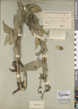
LE 01259695
Tamarindus indica L. det. Byalt, Vyacheslav Vyacheslavovich
Collectors: Byalt, Vyacheslav Vyacheslavovich; Korshunov, Mikhail Vladimirovich Field collecting number: 1167a. Collection date: 26.03.2020. Administrative regions: AE - United Arab Emirates. Place of collection: Fujairah Emirate, Al Bidya, gardens near roundabout, 0.8 km on E99 road to Dibba (north), on roadside, near garden wall, cultivated in irrigated pit and run wild.Groups of specimens: Образцы общего сектора; Соглашение Минобрнауки №075-15-2021-1056; The Fujairah Scientific Herbarium (FSH); Бялт В.В.: Флора ФуджейрыOriginal label text: United Arab Emirates, Fujairah Emirate, Al Bidya, gardens near roundabout, 0.8 km on E99 road to Dibba (north), 25°26'44.46"N, 56°21'27.16"E, elevation 4 m: on roadside, near garden wall, cultivated in irrigated pit and run wild, 26 III 2020, V.V. Byalt, M.V. Korshunov 1167a
LE 01262671
Groups of specimens: Образцы сектора Кавказа; Типовые образцы сектора Кавказа; Соглашение Минобрнауки №075-15-2021-1056Record creation: 2023-11-22, Elena Portenier, PhotoScan D2.Citation: Specimen LE 01262671 // Virtual herbarium of Komarov Botanical Institute RAS — http://re.herbariumle.ru/01262671
LE 01259694
Tamarindus indica L. det. Byalt, Vyacheslav Vyacheslavovich
Collectors: Byalt, Vyacheslav Vyacheslavovich; Korshunov, Mikhail Vladimirovich Field collecting number: 1167. Collection date: 26.03.2020. Administrative regions: AE - United Arab Emirates. Place of collection: Fujariah Emirate, Rul Dadhna, drainage channel, buildings: cultivated and run wild on roadside near drenaige.Groups of specimens: Образцы общего сектора; Соглашение Минобрнауки №075-15-2021-1056; Бялт В.В.: Флора Фуджейры; The Fujairah Scientific Herbarium (FSH)Original label text: United Arab Emirates, Fujariah Emirate, Rul Dadhna, drainage channel, buildings. 25°31'9.23"N, 56°21'19.67"E, elevation 13 m.: cultivated and run wild on roadside near drenaige, 26 III 2020, V.V. Byalt, M.V. Korshunov 1167
LE 01262670
Groups of specimens: Образцы сектора Кавказа; Типовые образцы сектора Кавказа; Соглашение Минобрнауки №075-15-2021-1056Record creation: 2023-11-22, Elena Portenier, PhotoScan D2.Citation: Specimen LE 01262670 // Virtual herbarium of Komarov Botanical Institute RAS — http://re.herbariumle.ru/01262670
LE 01259693
Leucaena leucocephala (Lam.) de Wit det. Byalt, Vyacheslav Vyacheslavovich
Collectors: Byalt, Vyacheslav Vyacheslavovich; Korshunov, Mikhail Vladimirovich Field collecting number: s.n. Collection date: 26.05.2020. Administrative regions: AE - United Arab Emirates. Place of collection: Fujairah Emirate, Al Aqah, 25°30'6.28"N, 56°21'30.01"E, elevation 14 m [point 792].Groups of specimens: Образцы общего сектора; Соглашение Минобрнауки №075-15-2021-1056; Бялт В.В.: Флора Фуджейры; The Fujairah Scientific Herbarium (FSH)Original label text: United Arab Emirates, Fujairah Emirate, Al Aqah, 25°30'6.28"N, 56°21'30.01"E, elevation 14 m. [point 792]: on drainage near wall of villa; in irrigation circles; under tree; on roadside; waste place near villa, 26 V 2020, V.V. Byalt, M.V. Korshunov s.n
LE 01262669
Groups of specimens: Образцы сектора Кавказа; Типовые образцы сектора Кавказа; Соглашение Минобрнауки №075-15-2021-1056Record creation: 2023-11-22, Elena Portenier, PhotoScan D2.Citation: Specimen LE 01262669 // Virtual herbarium of Komarov Botanical Institute RAS — http://re.herbariumle.ru/01262669
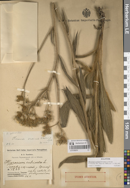
LE 01262668
Groups of specimens: Образцы сектора Кавказа; Типовые образцы сектора Кавказа; Соглашение Минобрнауки №075-15-2021-1056Record creation: 2023-11-22, Elena Portenier, PhotoScan D2.Citation: Specimen LE 01262668 // Virtual herbarium of Komarov Botanical Institute RAS — http://re.herbariumle.ru/01262668
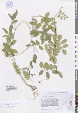
LE 01259692
Clitoria ternatea L. det. Byalt, Vyacheslav Vyacheslavovich
Collectors: Byalt, Vyacheslav Vyacheslavovich; Korshunov, Mikhail Vladimirovich Field collecting number: 3744(2). Collection date: 22.06.2020. Administrative regions: AE - United Arab Emirates. Place of collection: Fujairah Emirate, Al Bidiya, 0.4 km to South from Eid Prayer Ground Bidyah [point 801]: cultivated and run wild in and between plastic pots, in shade.Groups of specimens: Образцы общего сектора; Соглашение Минобрнауки №075-15-2021-1056; The Fujairah Scientific Herbarium (FSH); Бялт В.В.: Флора ФуджейрыOriginal label text: United Arab Emirates, Fujairah Emirate, Al Bidiya, 0.4 km to South from Eid Prayer Ground Bidyah, 25°25'13.53"N, 56°20'27.57"E, elevation 18 m [point 801]: cultivated and run wild in and between plastic pots, in shade, 22 VI 2020, V.V. Byalt, M.V. Korshunov 2744 (2)
LE 01262667
Groups of specimens: Образцы сектора Кавказа; Типовые образцы сектора Кавказа; Соглашение Минобрнауки №075-15-2021-1056Record creation: 2023-11-22, Elena Portenier, PhotoScan D2.Citation: Specimen LE 01262667 // Virtual herbarium of Komarov Botanical Institute RAS — http://re.herbariumle.ru/01262667

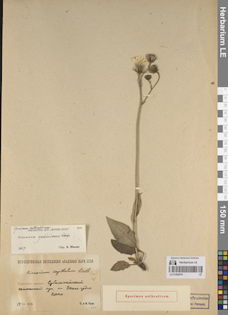
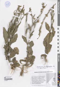
LE 01259690
Melilotus indicus (L.) All. det. Byalt, Vyacheslav Vyacheslavovich
Collectors: Byalt, Vyacheslav Vyacheslavovich; Korshunov, Mikhail Vladimirovich Field collecting number: 1515. Collection date: 01.04.2020. Administrative regions: AE - United Arab Emirates. Place of collection: Fujairah Emirate, Al Siji, Al Siji dump wasting area [point 727]: agricultural and household trash in wadi.Groups of specimens: Образцы общего сектора; Соглашение Минобрнауки №075-15-2021-1056; Бялт В.В.: Флора ФуджейрыOriginal label text: United Arab Emirates, Fujairah Emirate, Al Siji, Al Siji dump wasting area. 25°16'7.17"N, 56° 0'37.91"E, elevation 200 m. [point 727]: agricultural and houshold trash in wadi, 1 IV 2020, V.V. Byalt, M.V. Korshunov 1515
LE 01259691
Melilotus indicus (L.) All. det. Byalt, Vyacheslav Vyacheslavovich
Collectors: Byalt, Vyacheslav Vyacheslavovich; Korshunov, Mikhail Vladimirovich Field collecting number: 1503. Collection date: 23.11.2019. Administrative regions: AE - United Arab Emirates. Place of collection: Фуджейра, горы Хаджар. Старая дорога Масафи-Дибба, сады в северо-западной окрестности пос. Аль Хала, сорное в частном саду Абдулы, сеянец.Groups of specimens: Образцы общего сектора; Соглашение Минобрнауки №075-15-2021-1056; Бялт В.В.: Флора ФуджейрыOriginal label text: United Arab Emirates. Mts. Hajar. Old road Masafi-Dibba, gardens in NW environs of vil. Al Khala, 25°29'02.84"N 56°11'22"E, ca. 180 m alt.: weed in the private garden of Abdulah, seedling. – ОАЭ, Фуджейра, горы Хаджар. Старая дорога Масафи-Дибба, сады в сев.-зап. окр. пос. Аль Хала, 25 ° 29'02.84 "N 56 ° 11'22" E, ок. 180 м н. ур. м.: сорняк в частном саду Абдулы, сеянец, 23 XI 2019 V.V. Byalt, M.V. Korshunov 1503
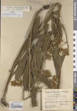
LE 01262666
Groups of specimens: Образцы сектора Кавказа; Типовые образцы сектора Кавказа; Соглашение Минобрнауки №075-15-2021-1056Record creation: 2023-11-22, Elena Portenier, PhotoScan D2.Citation: Specimen LE 01262666 // Virtual herbarium of Komarov Botanical Institute RAS — http://re.herbariumle.ru/01262666
LE 01259688
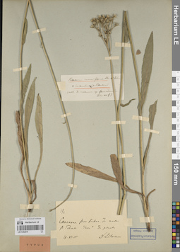
Melilotus albus L. det. Byalt, Vyacheslav Vyacheslavovich
Collectors: Byalt, Vyacheslav Vyacheslavovich; Korshunov, Mikhail Vladimirovich Field collecting number: 1567. Collection date: 01.04.2020. Administrative regions: AE - United Arab Emirates. Place of collection: Fujairah Emirate, Al Siji, Al Siji dump wasting area [point 727]: agricultural and household trash in wadi.Groups of specimens: Образцы общего сектора; Соглашение Минобрнауки №075-15-2021-1056; Бялт В.В.: Флора ФуджейрыOriginal label text: United Arab Emirates, Fujairah Emirate, Al Siji, Al Siji dump wasting area. 25°16'7.17"N, 56° 0'37.91"E, elevation 200 m. [point 727]: agricultural and houshold trash in wadi, fl. white, 1 IV 2020, V.V. Byalt, M.V. Korshunov 1567

LE 01259689
Melilotus albus Medikus det. Byalt, Vyacheslav Vyacheslavovich
Collectors: Byalt, Vyacheslav Vyacheslavovich; Korshunov, Mikhail Vladimirovich Field collecting number: 211. Collection date: 11.03.2020. Administrative regions: AE - United Arab Emirates. Place of collection: Fujairah Emirate, Al Hayl Fort (Al Hayl Castle) [point 704]: wadi bottom.Groups of specimens: Образцы общего сектора; Соглашение Минобрнауки №075-15-2021-1056; Бялт В.В.: Флора ФуджейрыOriginal label text: United Arab Emirates, Fujairah Emirate, Al Hayl Fort (Al Hayl Castle). 25° 5'4.59"N, 56°13'36.84"E, elevation 240–310 m [point 704]: wadi bottom, 11 III 2020, V.V. Byalt, M.V. Korshunov 211
LE 01262665
Groups of specimens: Образцы сектора Кавказа; Типовые образцы сектора Кавказа; Соглашение Минобрнауки №075-15-2021-1056Record creation: 2023-11-22, Elena Portenier, PhotoScan D2.Citation: Specimen LE 01262665 // Virtual herbarium of Komarov Botanical Institute RAS — http://re.herbariumle.ru/01262665
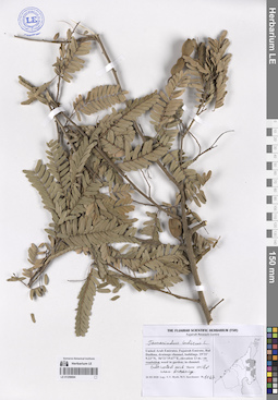
LE 01259687
Pithecellobium dulce (Roxb.) Benth. det. Byalt, Vyacheslav Vyacheslavovich
Collectors: Byalt, Vyacheslav Vyacheslavovich; Korshunov, Mikhail Vladimirovich Field collecting number: s.n. Collection date: 08.06.2020. Administrative regions: AE - United Arab Emirates. Place of collection: Fujairah Emirate, Al Dibba town, The Green Nursery Sales Dibba, 0.2 km South from Khalid Hadi Resort Dibba.Groups of specimens: Образцы общего сектора; Соглашение Минобрнауки №075-15-2021-1056; Бялт В.В.: Флора ФуджейрыOriginal label text: United Arab Emirates, Fujairah Emirate, Al Dibba town, The Green Nursery Sales Dibba, 0.2 km South from Khalid Hadi Resort Dibba. 25°34'29.81"N, 56°14'16.32"E, elevation 44 m [point 795]: cultivated / weed / run wild on irrigated plantation, plastic pots, under tree, in shade, between irrigated lines, without irrigation on abandoned land, under palm trees, on sand paths. 8 VI 2020, V.V. Byalt, M.V. Korshunov s.n
LE 01262664
Groups of specimens: Образцы сектора Кавказа; Типовые образцы сектора Кавказа; Соглашение Минобрнауки №075-15-2021-1056Record creation: 2023-11-22, Elena Portenier, PhotoScan D2.Citation: Specimen LE 01262664 // Virtual herbarium of Komarov Botanical Institute RAS — http://re.herbariumle.ru/01262664
LE 01259686
Pithecellobium dulce (Roxb.) Benth. det. Byalt, Vyacheslav Vyacheslavovich
Collectors: Byalt, Vyacheslav Vyacheslavovich; Korshunov, Mikhail Vladimirovich Field collecting number: 1163. Collection date: 26.03.2020. Administrative regions: AE - United Arab Emirates. Place of collection: Fujairah Emirate, Al Bidya, gardens near roundabout, 0.8 km on E99 road to Dibba (north), on roadsides, in shady backstreet.Groups of specimens: Образцы общего сектора; Соглашение Минобрнауки №075-15-2021-1056; Бялт В.В.: Флора ФуджейрыOriginal label text: United Arab Emirates, Fujairah Emirate, Al Bidya, gardens near roundabout, 0.8 km on E99 road to Dibba (north), 25°26'44.46"N, 56°21'27.16"E, elevation 4 m: on roadsides, in shady backstreet, 26 III 2020, V.V. Byalt, M.V. Korshunov 1163
LE 01262663
Groups of specimens: Образцы сектора Кавказа; Типовые образцы сектора Кавказа; Соглашение Минобрнауки №075-15-2021-1056Record creation: 2023-11-22, Elena Portenier, PhotoScan D2.Citation: Specimen LE 01262663 // Virtual herbarium of Komarov Botanical Institute RAS — http://re.herbariumle.ru/01262663