View
Add
Copy
Edit
Delete
LE 01259785
Coriandrum sativum L. det. Byalt, Vyacheslav Vyacheslavovich
Collectors: Byalt, Vyacheslav Vyacheslavovich; Korshunov, Mikhail Vladimirovich Field collecting number: s.n. Collection date: 01.04.2020. Administrative regions: AE - United Arab Emirates. Place of collection: Fujairah Emirate, Al Bidya, ADNOC Petrol station, on roadside gravel grasspot with watering.Groups of specimens: Образцы общего сектора; Соглашение Минобрнауки №075-15-2021-1056; Бялт В.В.: Флора ФуджейрыOriginal label text: United Arab Emirates, Fujairah Emirate, Al Bidya, ADNOC Petrol station. 25°25'36.70"N, 56°21'2.27"E, elevation 10 m: on roadside gravel grasspot with watering, 1 IV 2020, V.V. Byalt, M.V. Korshunov s.n
LE 01263615
Groups of specimens: Образцы сектора Центральной и Восточной Азии; Соглашение Минобрнауки №075-15-2021-1056Record creation: 2023-12-13, Artyom Leostrin, PhotoScan D2.Citation: Specimen LE 01263615 // Virtual herbarium of Komarov Botanical Institute RAS — http://re.herbariumle.ru/01263615
LE 01263520
Groups of specimens: Образцы сектора Центральной и Восточной Азии; Соглашение Минобрнауки №075-15-2021-1056Record creation: 2023-12-12, Artyom Leostrin, PhotoScan D2. Part 1.Citation: Specimen LE 01263520 // Virtual herbarium of Komarov Botanical Institute RAS — http://re.herbariumle.ru/01263520
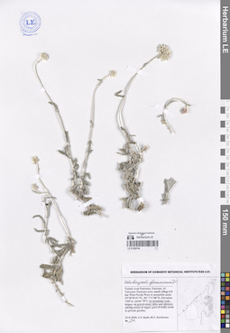
LE 01259784
Helichrysum glumaceum DC. det. Byalt, Vyacheslav Vyacheslavovich
Collectors: Byalt, Vyacheslav Vyacheslavovich; Korshunov, Mikhail Vladimirovich Field collecting number: 501. Collection date: 13.03.2020. Administrative regions: AE - United Arab Emirates. Place of collection: Fujairah Emirate, Al Tawyeen (Taween) area, small village 0.8 km West-North-West to mountain peak [point 707]: on gravel-stony sides and plateau.Groups of specimens: Образцы общего сектора; Соглашение Минобрнауки №075-15-2021-1056; Бялт В.В.: Флора ФуджейрыOriginal label text: UAE, Fujairah Emirate, Al Tawyeen (Taween) area, small village 0.8 km West-North-West to mountain peak. 25°38'59.41"N, 56° 7'17.88"E, elevation 1360 m. [point 707]: on gravel-stony sides and plateau, 13 III 2020, fl., V.V. Byalt, M.V. Korshunov 501
LE 01263614
Groups of specimens: Образцы сектора Центральной и Восточной Азии; Соглашение Минобрнауки №075-15-2021-1056Record creation: 2023-12-13, Artyom Leostrin, PhotoScan D2.Citation: Specimen LE 01263614 // Virtual herbarium of Komarov Botanical Institute RAS — http://re.herbariumle.ru/01263614
LE 01263519
Groups of specimens: Образцы сектора Центральной и Восточной Азии; Соглашение Минобрнауки №075-15-2021-1056Record creation: 2023-12-12, Artyom Leostrin, PhotoScan D2. Part 1.Citation: Specimen LE 01263519 // Virtual herbarium of Komarov Botanical Institute RAS — http://re.herbariumle.ru/01263519
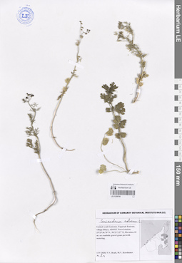
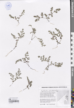
LE 01259783
Euphorbia granulata Forssk. ⟮s. l.⟯ det. Geltman, Dmitri Victorovich at 05.2023
Additional identifications: Euphorbia sp. det. Byalt, Vyacheslav Vyacheslavovich; Euphorbia turcomanica Boiss. det. Byalt, Vyacheslav Vyacheslavovich Collectors: Byalt, Vyacheslav Vyacheslavovich Field collecting number: 322. Collection date: 27.03.2017. Administrative regions: AE - United Arab Emirates. Place of collection: Фуджейра, окрестности пос. Тавайан, каменистое плато.Groups of specimens: Образцы общего сектора; Соглашение Минобрнауки №075-15-2021-1056; Бялт В.В.: Флора ФуджейрыOriginal label text: United Arab Emirates. Emirate of Fujaira, environs of Tawaian, 25°38, 989’ N, 56° 07, 296’ E, 1200–1367 m alt.: stony plateau. – ОАЭ, Фуджейра, окрестности пос. Тавайан, 25°38, 989’ N, 56° 07, 296’ E, 1200–1367 м н. ур. м.: каменистое плото, 27 III 2017, V.V. Byalt 322
LE 01268103
Groups of specimens: Образцы сектора Кавказа; Соглашение Минобрнауки №075-15-2021-1056Record creation: 2023-12-13, Ivan Tatanov, PhotoScan D2.Citation: Specimen LE 01268103 // Virtual herbarium of Komarov Botanical Institute RAS — http://re.herbariumle.ru/01268103

LE 01263612
Groups of specimens: Образцы сектора Центральной и Восточной Азии; Соглашение Минобрнауки №075-15-2021-1056Record creation: 2023-12-13, Artyom Leostrin, PhotoScan D2.Citation: Specimen LE 01263612 // Virtual herbarium of Komarov Botanical Institute RAS — http://re.herbariumle.ru/01263612
LE 01263613
Groups of specimens: Образцы сектора Центральной и Восточной Азии; Соглашение Минобрнауки №075-15-2021-1056Record creation: 2023-12-13, Artyom Leostrin, PhotoScan D2.Citation: Specimen LE 01263613 // Virtual herbarium of Komarov Botanical Institute RAS — http://re.herbariumle.ru/01263613
LE 01263518
Groups of specimens: Образцы сектора Центральной и Восточной Азии; Соглашение Минобрнауки №075-15-2021-1056Record creation: 2023-12-12, Artyom Leostrin, PhotoScan D2. Part 1.Citation: Specimen LE 01263518 // Virtual herbarium of Komarov Botanical Institute RAS — http://re.herbariumle.ru/01263518
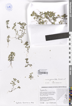
LE 01259782
Euphorbia granulata Forssk. det. Byalt, Vyacheslav Vyacheslavovich
Collectors: Byalt, Vyacheslav Vyacheslavovich Field collecting number: 245. Collection date: 26.03.2017. Administrative regions: AE - United Arab Emirates. Place of collection: Фуджейра, окрестности г. Дадна, широкая горная долина и горные склоны: скалы и каменистые склоны северо-западной экспозиции.Groups of specimens: Образцы общего сектора; Соглашение Минобрнауки №075-15-2021-1056; Бялт В.В.: Флора ФуджейрыOriginal label text: United Arab Emirates. Emirate of Fujaira, environs of Dadna, 25°24, 018’ N, 56° 17,475’ E: wide mountain valley and mountain slopeson rocks and stony slopes NW exp. Фуджейра, окрестности г. Дадна, 25°24, 018’ N, 56° 17,475’ E: широкая горная долина и горные склоны: на скалах и каменистых склонах NW эксп., 26-27 III 2017, fl., Byalt 245
LE 01268102
Groups of specimens: Образцы сектора Кавказа; Соглашение Минобрнауки №075-15-2021-1056Record creation: 2023-12-13, Ivan Tatanov, PhotoScan D2.Citation: Specimen LE 01268102 // Virtual herbarium of Komarov Botanical Institute RAS — http://re.herbariumle.ru/01268102
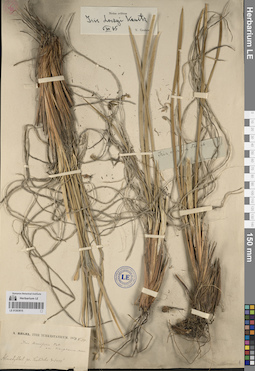
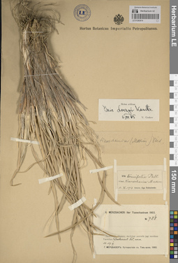
LE 01071967
Groups of specimens: Образцы сектора Центральной и Восточной Азии; Соглашение Минобрнауки №075-15-2021-1056Record creation: 2023-12-13, Artyom Leostrin, PhotoScan D2.Citation: Specimen LE 01071967 // Virtual herbarium of Komarov Botanical Institute RAS — http://re.herbariumle.ru/01071967
LE 01263517
Groups of specimens: Образцы сектора Центральной и Восточной Азии; Соглашение Минобрнауки №075-15-2021-1056Record creation: 2023-12-12, Artyom Leostrin, PhotoScan D2. Part 1.Citation: Specimen LE 01263517 // Virtual herbarium of Komarov Botanical Institute RAS — http://re.herbariumle.ru/01263517
LE 01268101
Groups of specimens: Образцы сектора Кавказа; Соглашение Минобрнауки №075-15-2021-1056Record creation: 2023-12-13, Ivan Tatanov, PhotoScan D2.Citation: Specimen LE 01268101 // Virtual herbarium of Komarov Botanical Institute RAS — http://re.herbariumle.ru/01268101
LE 01259781
Euphorbia granulata var. glabrata (J.Gay) Boiss. det. Byalt, Vyacheslav Vyacheslavovich
Collectors: Byalt, Vyacheslav Vyacheslavovich Field collecting number: 87. Collection date: 22.03.2017. Administrative regions: AE - United Arab Emirates. Place of collection: Фуджейра, Вади Вурайа Национальный парк, в 8 км северо-западнее г. Хор Факкан, огороженные загоны для таров в горах: в низине; на каменистом склоне; низинки с песком среди каменных полей (с поливом).Groups of specimens: Образцы общего сектора; Соглашение Минобрнауки №075-15-2021-1056; Бялт В.В.: Флора ФуджейрыOriginal label text: United Arab Emirates. Emirate of Fujaira, Wadi Wurayah National Park, 8 km NW from Khor Fakkan, ca. 25°23’ N, 56° 18’ E, ca. 160–170 m alt., fenced paddocks for tar in the mountains: in the hollow; on gravelly slopes; the hollows with sand among the stone fields (with irrigation). – ОАЭ, Фуджейра, Вади Вурайа Национальный парк, в 8 км к СЗ от г. Хор Факкан, ca. 25°23’ N, 56° 18’ E, огороженные загоны для таров в горах: в низине; на каменистом склоне; низинки с песком среди каменных полей (с поливом), 22 III 2017, V.V. Byalt 87
LE 01071966
Groups of specimens: Образцы сектора Центральной и Восточной Азии; Соглашение Минобрнауки №075-15-2021-1056Record creation: 2023-12-13, Artyom Leostrin, PhotoScan D2.Citation: Specimen LE 01071966 // Virtual herbarium of Komarov Botanical Institute RAS — http://re.herbariumle.ru/01071966
LE 01263516
Groups of specimens: Образцы сектора Центральной и Восточной Азии; Соглашение Минобрнауки №075-15-2021-1056Record creation: 2023-12-12, Artyom Leostrin, PhotoScan D2. Part 1.Citation: Specimen LE 01263516 // Virtual herbarium of Komarov Botanical Institute RAS — http://re.herbariumle.ru/01263516
LE 01268100
Groups of specimens: Образцы сектора Кавказа; Соглашение Минобрнауки №075-15-2021-1056Record creation: 2023-12-13, Ivan Tatanov, PhotoScan D2.Citation: Specimen LE 01268100 // Virtual herbarium of Komarov Botanical Institute RAS — http://re.herbariumle.ru/01268100
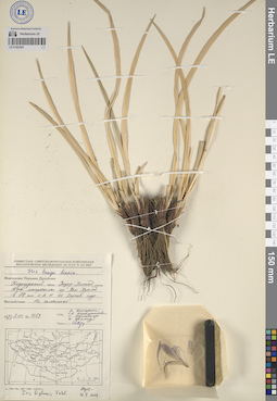
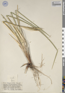
LE 01071965
Groups of specimens: Образцы сектора Центральной и Восточной Азии; Соглашение Минобрнауки №075-15-2021-1056Record creation: 2023-12-13, Artyom Leostrin, PhotoScan D2.Citation: Specimen LE 01071965 // Virtual herbarium of Komarov Botanical Institute RAS — http://re.herbariumle.ru/01071965
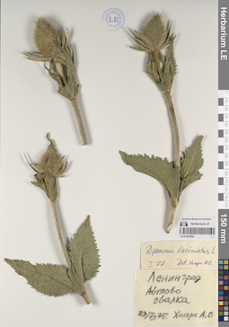
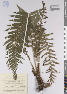
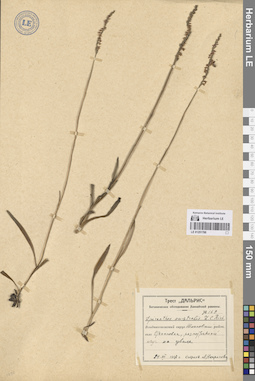
LE 01241992
Dipsacus laciniatus L.
Groups of specimens: Образцы сектора Восточной Европы; Соглашение Минобрнауки №075-15-2021-1056Record creation: 2023-12-12, Artyom Leostrin, PhotoScan D2. Part 2.Citation: Specimen LE 01241992 // Virtual herbarium of Komarov Botanical Institute RAS — http://re.herbariumle.ru/01241992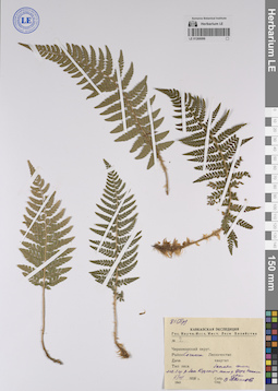
LE 01268099
Groups of specimens: Образцы сектора Кавказа; Соглашение Минобрнауки №075-15-2021-1056Record creation: 2023-12-13, Ivan Tatanov, PhotoScan D2.Citation: Specimen LE 01268099 // Virtual herbarium of Komarov Botanical Institute RAS — http://re.herbariumle.ru/01268099
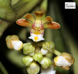
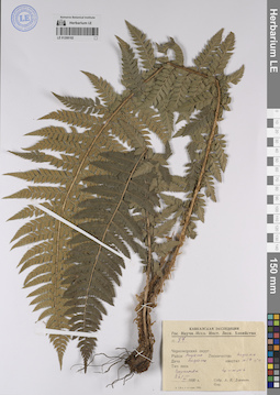
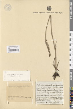
LE 01124752
Gastrochilus acutifolius (Lindl.) Kuntze det. Averyanov, Leonid Vladimirovich at 15.12.2023
Collectors: Dinh Quang Diep Field collecting number: AL2809. Collection date: 14.12.2023. Administrative regions: VN - Tinh Quang Binh. Groups of specimens: L. V. Averyanov specimens; L. V. Averyanov photos; Flora of Vietnam; Orchids of Vietnam, Laos and CambodiaOriginal label text:FLORA OF VIETNAM
Orchidaceae
Gastrochilus acutifolius (Lindl.) Kuntze
Wild collected plant flowering in private garden in Kon Tum Town, Kon Tum Province, originated from Quang Binh Province.
14 December 2023, Dinh Quang Diep, AL2809.
All photos © - Dinh Quang Diep
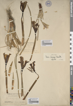
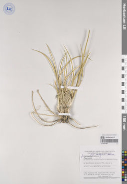
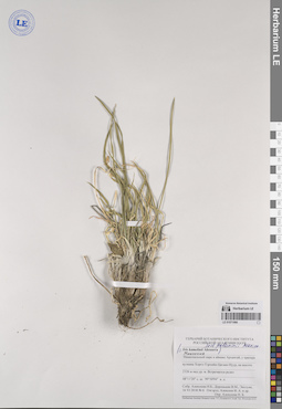
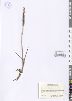
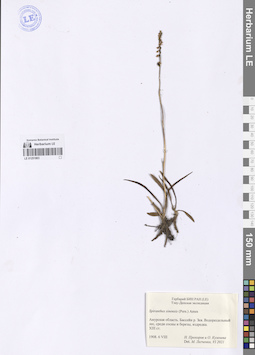
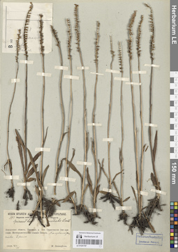
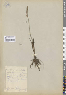
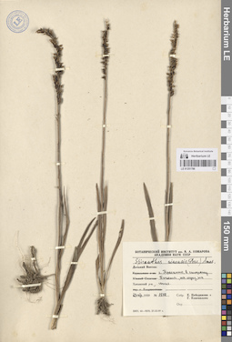
LE 01251810
Coeloglossum viride (L.) Hartm.
Collectors: Katenin, Adrian Evgenevich; Sekretareva, Nadezhda Alexandrovna Collection date: 17.07.1983. Administrative regions: RU - Chukotskiy Avtonomnyy Okrug - Providenskiy Rayon. Groups of specimens: Образцы сектора Сибири и Дальнего Востока России; Соглашение Минобрнауки №075-15-2021-1056Original label text:Южная часть Чукотского полуострова, левобережье р. Синевеем в 15 км от устья. Нижняя часть склона сопки, разнотравно-кустарничково-голубично-шикшевая тундра.
Coordinates (geographic position): 64° 36′ 37.85″ N, 173° 50′ 40.01″ W ±1000 mRecord creation: 2023-12-15, Marina Yarichina, PhotoScan D2.Citation: Specimen LE 01251810 // Virtual herbarium of Komarov Botanical Institute RAS — http://re.herbariumle.ru/01251810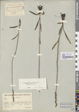
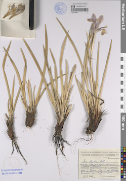
LE 01251809
Groups of specimens: Образцы сектора Сибири и Дальнего Востока России; Соглашение Минобрнауки №075-15-2021-1056Record creation: 2023-12-15, Marina Yarichina, PhotoScan D2.Citation: Specimen LE 01251809 // Virtual herbarium of Komarov Botanical Institute RAS — http://re.herbariumle.ru/01251809
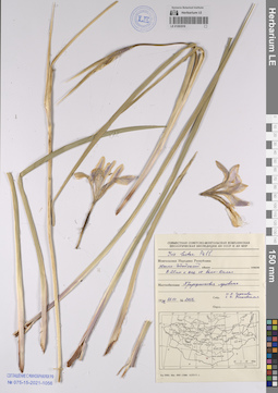
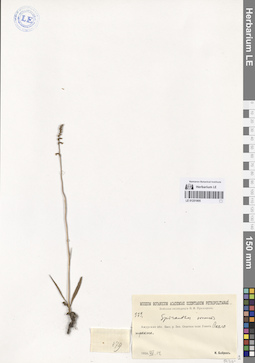
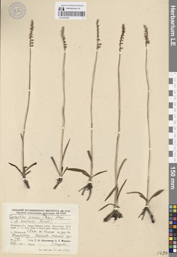
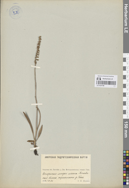
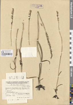
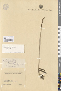
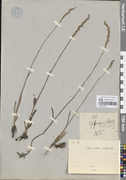
LE 01251808
Spiranthes sinensis (Pers.) Ames det. Legchenko, Marina Vitaljevna at 06.2021
Collectors: Prokhorov, Nikolay Ivanovich; Kuzeneva, Olga Iakinfovna Collection date: 06.08.1908. Administrative regions: RU - Amurskaya Oblast'. Groups of specimens: Образцы сектора Сибири и Дальнего Востока России; Соглашение Минобрнауки №075-15-2021-1056Original label text:Амурская область, бассейн р. Зея. Водораздельный лес, среди березы и сосны, изредка.
Record creation: 2023-12-15, Marina Yarichina, PhotoScan D2.Citation: Specimen LE 01251808 // Virtual herbarium of Komarov Botanical Institute RAS — http://re.herbariumle.ru/01251808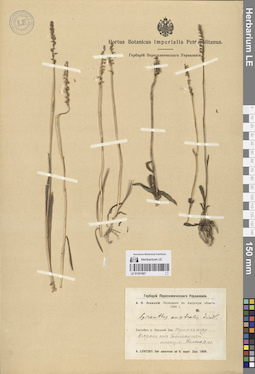
LE 01251807
Groups of specimens: Образцы сектора Сибири и Дальнего Востока России; Соглашение Минобрнауки №075-15-2021-1056Record creation: 2023-12-15, Marina Yarichina, PhotoScan D2.Citation: Specimen LE 01251807 // Virtual herbarium of Komarov Botanical Institute RAS — http://re.herbariumle.ru/01251807
LE 01251806
Groups of specimens: Образцы сектора Сибири и Дальнего Востока России; Соглашение Минобрнауки №075-15-2021-1056Record creation: 2023-12-15, Marina Yarichina, PhotoScan D2.Citation: Specimen LE 01251806 // Virtual herbarium of Komarov Botanical Institute RAS — http://re.herbariumle.ru/01251806
LE 01251805
Groups of specimens: Образцы сектора Сибири и Дальнего Востока России; Соглашение Минобрнауки №075-15-2021-1056Record creation: 2023-12-15, Marina Yarichina, PhotoScan D2.Citation: Specimen LE 01251805 // Virtual herbarium of Komarov Botanical Institute RAS — http://re.herbariumle.ru/01251805
LE 01251804
Groups of specimens: Образцы сектора Сибири и Дальнего Востока России; Соглашение Минобрнауки №075-15-2021-1056Record creation: 2023-12-15, Marina Yarichina, PhotoScan D2.Citation: Specimen LE 01251804 // Virtual herbarium of Komarov Botanical Institute RAS — http://re.herbariumle.ru/01251804
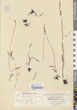
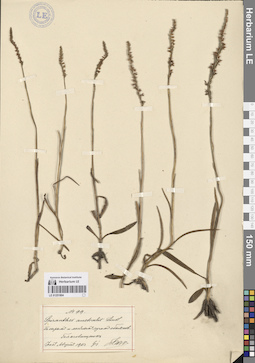
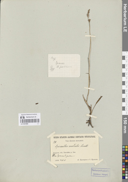
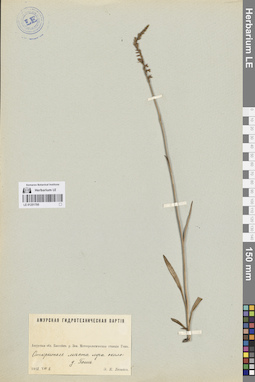
LE 01251803
Spiranthes sinensis (Pers.) Ames det. Legchenko, Marina Vitaljevna at 06.2021
Collectors: Prokhorov, Nikolay Ivanovich; Kuzeneva, Olga Iakinfovna Collection date: 06.08.1908. Administrative regions: RU - Amurskaya Oblast'. Groups of specimens: Образцы сектора Сибири и Дальнего Востока России; Соглашение Минобрнауки №075-15-2021-1056Original label text:Амурская область, бассейн р. Зея. Водораздельный лес, среди березы и сосны, изредка.
Record creation: 2023-12-15, Marina Yarichina, PhotoScan D2.Citation: Specimen LE 01251803 // Virtual herbarium of Komarov Botanical Institute RAS — http://re.herbariumle.ru/01251803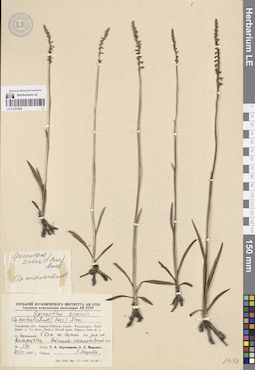
LE 01251802
Groups of specimens: Образцы сектора Сибири и Дальнего Востока России; Соглашение Минобрнауки №075-15-2021-1056Record creation: 2023-12-15, Marina Yarichina, PhotoScan D2.Citation: Specimen LE 01251802 // Virtual herbarium of Komarov Botanical Institute RAS — http://re.herbariumle.ru/01251802
LE 01251801
Groups of specimens: Образцы сектора Сибири и Дальнего Востока России; Соглашение Минобрнауки №075-15-2021-1056Record creation: 2023-12-15, Marina Yarichina, PhotoScan D2.Citation: Specimen LE 01251801 // Virtual herbarium of Komarov Botanical Institute RAS — http://re.herbariumle.ru/01251801
LE 01251800
Groups of specimens: Образцы сектора Сибири и Дальнего Востока России; Соглашение Минобрнауки №075-15-2021-1056Record creation: 2023-12-15, Marina Yarichina, PhotoScan D2.Citation: Specimen LE 01251800 // Virtual herbarium of Komarov Botanical Institute RAS — http://re.herbariumle.ru/01251800
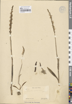
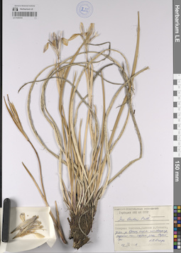
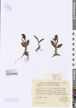
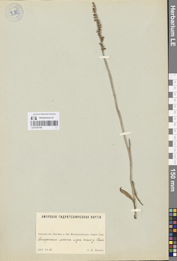
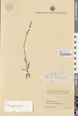
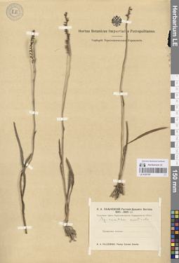
LE 01251799
Spiranthes sinensis (Pers.) Ames
Additional identifications: Spiranthes australis auct. det. Maximowicz, Carl Johann Collectors: Maack, Richard Otto Field collecting number: 604. Collection date: 1855. Groups of specimens: Образцы сектора Сибири и Дальнего Востока России; Соглашение Минобрнауки №075-15-2021-1056Original label text:Mandshuria, ad fl. Amur.
Record creation: 2023-12-15, Marina Yarichina, PhotoScan D2.Citation: Specimen LE 01251799 // Virtual herbarium of Komarov Botanical Institute RAS — http://re.herbariumle.ru/01251799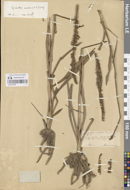
LE 01251798
Groups of specimens: Образцы сектора Сибири и Дальнего Востока России; Соглашение Минобрнауки №075-15-2021-1056Record creation: 2023-12-15, Marina Yarichina, PhotoScan D2.Citation: Specimen LE 01251798 // Virtual herbarium of Komarov Botanical Institute RAS — http://re.herbariumle.ru/01251798
LE 01251797
Groups of specimens: Образцы сектора Сибири и Дальнего Востока России; Соглашение Минобрнауки №075-15-2021-1056Record creation: 2023-12-15, Marina Yarichina, PhotoScan D2.Citation: Specimen LE 01251797 // Virtual herbarium of Komarov Botanical Institute RAS — http://re.herbariumle.ru/01251797
LE 01251796
Groups of specimens: Образцы сектора Сибири и Дальнего Востока России; Соглашение Минобрнауки №075-15-2021-1056Record creation: 2023-12-15, Marina Yarichina, PhotoScan D2.Citation: Specimen LE 01251796 // Virtual herbarium of Komarov Botanical Institute RAS — http://re.herbariumle.ru/01251796
LE 01251795
Groups of specimens: Образцы сектора Сибири и Дальнего Востока России; Соглашение Минобрнауки №075-15-2021-1056Record creation: 2023-12-15, Marina Yarichina, PhotoScan D2.Citation: Specimen LE 01251795 // Virtual herbarium of Komarov Botanical Institute RAS — http://re.herbariumle.ru/01251795
LE 01251794
Groups of specimens: Образцы сектора Сибири и Дальнего Востока России; Соглашение Минобрнауки №075-15-2021-1056Record creation: 2023-12-15, Marina Yarichina, PhotoScan D2.Citation: Specimen LE 01251794 // Virtual herbarium of Komarov Botanical Institute RAS — http://re.herbariumle.ru/01251794
LE 01251793
Groups of specimens: Образцы сектора Сибири и Дальнего Востока России; Соглашение Минобрнауки №075-15-2021-1056Record creation: 2023-12-15, Marina Yarichina, PhotoScan D2.Citation: Specimen LE 01251793 // Virtual herbarium of Komarov Botanical Institute RAS — http://re.herbariumle.ru/01251793
LE 01251792
Groups of specimens: Образцы сектора Сибири и Дальнего Востока России; Соглашение Минобрнауки №075-15-2021-1056Record creation: 2023-12-15, Marina Yarichina, PhotoScan D2.Citation: Specimen LE 01251792 // Virtual herbarium of Komarov Botanical Institute RAS — http://re.herbariumle.ru/01251792
LE 01251791
Groups of specimens: Образцы сектора Сибири и Дальнего Востока России; Соглашение Минобрнауки №075-15-2021-1056Record creation: 2023-12-15, Marina Yarichina, PhotoScan D2.Citation: Specimen LE 01251791 // Virtual herbarium of Komarov Botanical Institute RAS — http://re.herbariumle.ru/01251791
LE 01251790
Groups of specimens: Образцы сектора Сибири и Дальнего Востока России; Соглашение Минобрнауки №075-15-2021-1056Record creation: 2023-12-15, Marina Yarichina, PhotoScan D2.Citation: Specimen LE 01251790 // Virtual herbarium of Komarov Botanical Institute RAS — http://re.herbariumle.ru/01251790
LE 01251789
Groups of specimens: Образцы сектора Сибири и Дальнего Востока России; Соглашение Минобрнауки №075-15-2021-1056Record creation: 2023-12-15, Marina Yarichina, PhotoScan D2.Citation: Specimen LE 01251789 // Virtual herbarium of Komarov Botanical Institute RAS — http://re.herbariumle.ru/01251789
LE 01251788
Groups of specimens: Образцы сектора Сибири и Дальнего Востока России; Соглашение Минобрнауки №075-15-2021-1056Record creation: 2023-12-15, Marina Yarichina, PhotoScan D2.Citation: Specimen LE 01251788 // Virtual herbarium of Komarov Botanical Institute RAS — http://re.herbariumle.ru/01251788
LE 01251787
Groups of specimens: Образцы сектора Сибири и Дальнего Востока России; Соглашение Минобрнауки №075-15-2021-1056Record creation: 2023-12-15, Marina Yarichina, PhotoScan D2.Citation: Specimen LE 01251787 // Virtual herbarium of Komarov Botanical Institute RAS — http://re.herbariumle.ru/01251787
LE 01251786
Groups of specimens: Образцы сектора Сибири и Дальнего Востока России; Соглашение Минобрнауки №075-15-2021-1056Record creation: 2023-12-15, Marina Yarichina, PhotoScan D2.Citation: Specimen LE 01251786 // Virtual herbarium of Komarov Botanical Institute RAS — http://re.herbariumle.ru/01251786
LE 01251785
Groups of specimens: Образцы сектора Сибири и Дальнего Востока России; Соглашение Минобрнауки №075-15-2021-1056Record creation: 2023-12-15, Marina Yarichina, PhotoScan D2.Citation: Specimen LE 01251785 // Virtual herbarium of Komarov Botanical Institute RAS — http://re.herbariumle.ru/01251785