View
Add
Copy
Edit
Delete
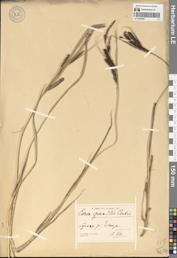
LE 01289248
Carex gracilis Curt. det. Pohle, Christian Nikolai Richard at 01.08.1905
Collectors: Pohle, Christian Nikolai Richard Collection date: 01.08.1905. Administrative regions: RU - Komi - Vorkuta (gorodskoj okrug). Топоним: Елец - река на Приполярном Урале. Place of collection: берег реки Елец.Groups of specimens: Образцы сектора Восточной Европы; Соглашение Минобрнауки №075-15-2021-1056; R. Pohle, Prov. Archangel, 1905Original label text:in tundra ad Ussam adjacente. берег реки Ельца
Landscape in location of collection: тундраRecord creation: 2024-06-06, PhotoScan D2.Citation: Specimen LE 01289248 // Virtual herbarium of Komarov Botanical Institute RAS — http://re.herbariumle.ru/01289248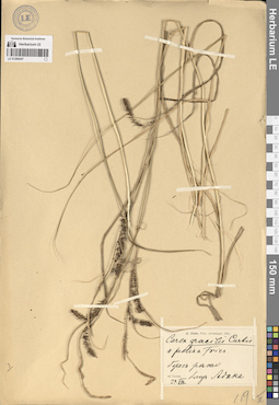
LE 01289247
Carex acuta L. var. prolixa det. Pohle, Christian Nikolai Richard at 29.08.1905
Collectors: Pohle, Christian Nikolai Richard Collection date: 29.08.1905. Administrative regions: RU - Komi - Inta (gorodskoj okrug). Топоним: урочище Адак, Инта. Place of collection: берег реки Печора.Groups of specimens: Образцы сектора Восточной Европы; Соглашение Минобрнауки №075-15-2021-1056; R. Pohle, Prov. Archangel, 1905Original label text:ad Ussam берег реки близь Адака
Landscape in location of collection: лесотундраRecord creation: 2024-06-06, PhotoScan D2.Citation: Specimen LE 01289247 // Virtual herbarium of Komarov Botanical Institute RAS — http://re.herbariumle.ru/01289247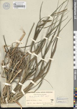
LE 01289246
Carex gracilis Curt. ⟮s. str.⟯ det. Zhuravskij, Andrej Vladimirovich, Nikolaevskij, B. I., Khorev, L. V., Rudnev, Dmitry Dmitryevich at 07.1909
Collectors: Zhuravskij, Andrej Vladimirovich; Nikolaevskij, B. I.; Khorev, L. V.; Rudnev, Dmitry Dmitryevich Field collecting number: 84. Collection date: 07.1909. Administrative regions: RU - Komi - Usinsk (gorodskoj okrug). Топоним: Колва — село в Городском округе Усинск Респ. Коми.. Expedition: Северо-Печорская экспедиция 1909 г. (1909)Groups of specimens: Образцы сектора Восточной Европы; Соглашение Минобрнауки №075-15-2021-1056; Herbarium Academiae Scientiarum Petropol.; Museum Botanicum Academiae Scientiarum PetropolitanaeOriginal label text:Архангельская губерния Печорский уезд село Колва.
Landscape in location of collection: лесотундраRecord creation: 2024-06-06, PhotoScan D2.Citation: Specimen LE 01289246 // Virtual herbarium of Komarov Botanical Institute RAS — http://re.herbariumle.ru/01289246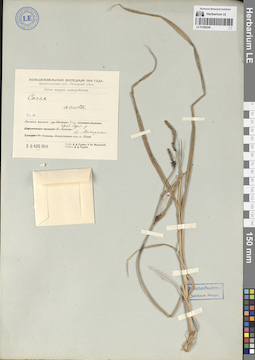
LE 01289245
Carex acuta L. det. Rudnev, Dmitry Dmitryevich at 20.08.1904
Collectors: Rudnev, Dmitry Dmitryevich; Zhuravskij, Andrej Vladimirovich Collection date: 20.08.1904. Administrative regions: RU - Komi - Usinsk (gorodskoj okrug). Топоним: Уса - река (приток Печоры) (нижнее течение). Place of collection: правый берег реки Уса, близ местечка Макариха.Expedition: Большеземельская экспедиция 1904 года (1904)Groups of specimens: Образцы сектора Восточной Европы; Соглашение Минобрнауки №075-15-2021-1056; Herbarium Academiae Scientiarum Petropol.; Архангельская губерния, Печорский уезд. Terra magna samojedarum.Original label text:Лесная полоса: река Уса, правый берег реки близ Макарихи
Landscape in location of collection: лесотундраRecord creation: 2024-06-06, PhotoScan D2.Citation: Specimen LE 01289245 // Virtual herbarium of Komarov Botanical Institute RAS — http://re.herbariumle.ru/01289245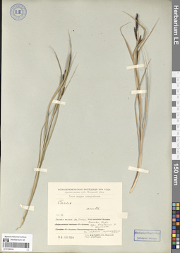
LE 01289244
Carex acuta L. det. Rudnev, Dmitry Dmitryevich at 26.06.1904
Collectors: Zhuravskij, Andrej Vladimirovich Collection date: 26.06.1904. Administrative regions: RU - Komi - Ust'-Tsilemskiy Rayon. Subregion: муниципальное образование Усть-Цильма. Топоним: бассейн Печоры (Печора, Печӧра (коми-язык), река в Республике Коми и Ненецком автономном округе). Place of collection: Попова Изба, при впадении реки Цильма в реку Печора.Expedition: Большеземельская экспедиция 1904 года (1904)Groups of specimens: Образцы сектора Восточной Европы; Соглашение Минобрнауки №075-15-2021-1056; Herbarium Academiae Scientiarum Petropol.; Архангельская губерния, Печорский уезд. Terra magna samojedarum.Original label text:Лесная полоса: река Печора, Попова Изба при впадении реки Цильмы. по сырым лужайкам леса
Landscape in location of collection: северная тайгаHabitat / plant community in location of collecting: по сырым лужайкам лесаRecord creation: 2024-06-06, PhotoScan D2.Citation: Specimen LE 01289244 // Virtual herbarium of Komarov Botanical Institute RAS — http://re.herbariumle.ru/01289244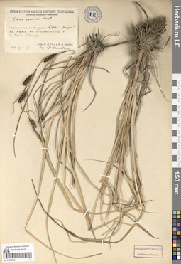
LE 01289242
Carex gracilis Curt. det. Sambuk, Feodosij Viktorovich at 17.09.1927
Collectors: Gaze, O.; Sambuk, Feodosij Viktorovich Collection date: 17.09.1927. Administrative regions: RU - Nenetskiy Avtonomnyy Okrug - Zapolyarny Rayon. Subregion: Тельвисочный сельсовет. Place of collection: по пути из села Тельвисочное в деревню Устье.Groups of specimens: Образцы сектора Восточной Европы; Соглашение Минобрнауки №075-15-2021-1056; Herbarium Academiae Scientiarum Petropol.; Museum Botanicum Academiae Scientiarum PetropolitanaeOriginal label text:Архангельская губерния Печорский уезд Берег "шара" по пути из Тельвисочного в деревню Устье (Печоры)
Landscape in location of collection: граница тундры и лесотундрыHabitat / plant community in location of collecting: берег шараRecord creation: 2024-06-06, PhotoScan D2.Citation: Specimen LE 01289242 // Virtual herbarium of Komarov Botanical Institute RAS — http://re.herbariumle.ru/01289242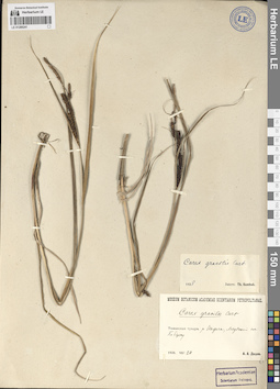
LE 01289241
Additional identifications: Carex gracilis Curt. det. Dedov, A. A. at 20.08.1928; Carex gracilis Curt. det. Sambuk, Feodosij Viktorovich at 1928 Collectors: Dedov, A. A. Collection date: 20.08.1928. Administrative regions: RU - Nenetskiy Avtonomnyy Okrug - Zapolyarny Rayon. Subregion: межселенные территории Заполярного района. Топоним: Индига, река в Ненецком АО.. Place of collection: поселок Медвежий, по берегу реки Индига.Groups of specimens: Образцы сектора Восточной Европы; Соглашение Минобрнауки №075-15-2021-1056; Herbarium Academiae Scientiarum Petropol.; Museum Botanicum Academiae Scientiarum PetropolitanaeOriginal label text:
Тиманская тундра. река Индига, Медвежий поселок По берегу
Landscape in location of collection: тундраRecord creation: 2024-06-06, PhotoScan D2.Citation: Specimen LE 01289241 // Virtual herbarium of Komarov Botanical Institute RAS — http://re.herbariumle.ru/01289241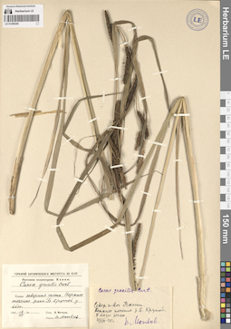
LE 01289240
Carex gracilis Curt. det. Matveev V. at 12.08.1945
Collectors: Matveev V. Collection date: 12.08.1945. Administrative regions: RU - Nenetskiy Avtonomnyy Okrug - Zapolyarny Rayon. Subregion: межселенные территории Заполярного района. Топоним: мыс Канин (север). Place of collection: верхнее течение реки Большой Крутой.Groups of specimens: Образцы сектора Восточной Европы; Соглашение Минобрнауки №075-15-2021-1056; Гербарий Ботанического института АН СССР; Растения полуострова КанинOriginal label text:Канин северная часть. Верхнее течение реки Большой Крутой у воды.
Landscape in location of collection: тундраHabitat / plant community in location of collecting: у водыRecord creation: 2024-06-06, PhotoScan D2.Citation: Specimen LE 01289240 // Virtual herbarium of Komarov Botanical Institute RAS — http://re.herbariumle.ru/01289240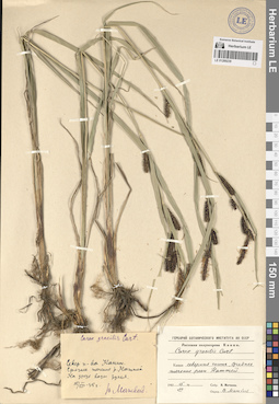
LE 01289239
Carex gracilis Curt. det. Matveev V. at 15.08.1945
Collectors: Matveev V. Collection date: 15.08.1945. Administrative regions: RU - Nenetskiy Avtonomnyy Okrug - Zapolyarny Rayon. Subregion: межселенные территории Заполярного района. Топоним: Наттей, река (п-ов Канин). Place of collection: северная часть полуострова Канин, среднее течение реки Наттей.Groups of specimens: Образцы сектора Восточной Европы; Соглашение Минобрнауки №075-15-2021-1056; Гербарий Ботанического института АН СССР; Растения полуострова КанинOriginal label text:Канин северная часть, среднее течение реки Наттей.
Landscape in location of collection: тундраRecord creation: 2024-06-06, PhotoScan D2.Citation: Specimen LE 01289239 // Virtual herbarium of Komarov Botanical Institute RAS — http://re.herbariumle.ru/01289239
LE 01289238
Carex gracilis Curt. var. tricostata (Fr.) Asch. f. brachystachya det. Dedov, A. A. at 05.08.1930
Collectors: Dedov, A. A. Collection date: 05.08.1930. Administrative regions: RU - Nenetskiy Avtonomnyy Okrug - Zapolyarny Rayon. Subregion: межселенные территории Заполярного района. Топоним: Малоземельская тундра. Place of collection: река Икига.Groups of specimens: Образцы сектора Восточной Европы; Соглашение Минобрнауки №075-15-2021-1056; Гербарий Всесоюзного Арктического институтаOriginal label text:Северный Край Малоземельская тундра река Икига.
Landscape in location of collection: тундраRecord creation: 2024-06-06, PhotoScan D2.Citation: Specimen LE 01289238 // Virtual herbarium of Komarov Botanical Institute RAS — http://re.herbariumle.ru/01289238
LE 01289237
Carex acuta L. det. Panfiljev G. at 15.07.1892
Collectors: Panfiljev G. Collection date: 15.07.1892. Administrative regions: RU - Nenetskiy Avtonomnyy Okrug - Zapolyarny Rayon. Subregion: межселенные территории Заполярного района. Топоним: Пёша, река в Архангельской области и Ненецком автономном округе.. Groups of specimens: Образцы сектора Восточной Европы; Соглашение Минобрнауки №075-15-2021-1056; Herbarium Arcticum Horti Petropolitani; Herbarium horti PetropolitaniOriginal label text:Луга. Пеша.
Landscape in location of collection: лесотундраHabitat / plant community in location of collecting: лугаRecord creation: 2024-06-06, PhotoScan D2.Citation: Specimen LE 01289237 // Virtual herbarium of Komarov Botanical Institute RAS — http://re.herbariumle.ru/01289237
LE 01289236
Collectors: Rudnev, Dmitry Dmitryevich Field collecting number: отряд 19. Collection date: 08.09.1921. Administrative regions: RU - Nenetskiy Avtonomnyy Okrug - Zapolyarny Rayon. Subregion: межселенные территории Заполярного района. Топоним: Шапкина, река в Ненецком АО и Республике Коми, правый приток реки Печоры.. Expedition: Большеземельский отряд Северной Научно-промысловой экспедиции (1926)Groups of specimens: Образцы сектора Восточной Европы; Соглашение Минобрнауки №075-15-2021-1056Original label text:
Тундра. Река Шапкина
Landscape in location of collection: тундраRecord creation: 2024-06-06, PhotoScan D2.Citation: Specimen LE 01289236 // Virtual herbarium of Komarov Botanical Institute RAS — http://re.herbariumle.ru/01289236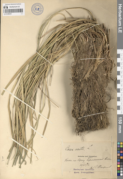
LE 01289235
Carex acuta L. det. Panfiljev G. at 21.07.1892
Collectors: Panfiljev G. Collection date: 21.07.1892. Administrative regions: RU - Nenetskiy Avtonomnyy Okrug - Zapolyarny Rayon. Subregion: межселенные территории Заполярного района. Топоним: Борматская виска (река Бормат, впадает в озеро Бормат). Place of collection: на берегу Борматской виски.Groups of specimens: Образцы сектора Восточной Европы; Соглашение Минобрнауки №075-15-2021-1056; Herbarium Arcticum Horti Petropolitani; Herbarium horti PetropolitaniOriginal label text:Кочки на берегу Борматской виски.
Landscape in location of collection: лесотундраHabitat / plant community in location of collecting: кочкиRecord creation: 2024-06-06, PhotoScan D2.Citation: Specimen LE 01289235 // Virtual herbarium of Komarov Botanical Institute RAS — http://re.herbariumle.ru/01289235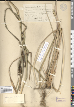
LE 01289234
Additional identifications: Carex acuta L. det. Andreev, Vladimir Nikolaevich at 24.07.1908; Carex aquatilis Wahlenb. det. Andreev, Vladimir Nikolaevich at 24.07.1908 Collectors: Andreev, Vladimir Nikolaevich Collection date: 24.07.1908. Administrative regions: RU - Komi - Kortkerosskiy Rayon. Subregion: муниципальное образование Нившера. Топоним: река Лопью. Place of collection: около села Грива.Groups of specimens: Образцы сектора Восточной Европы; Соглашение Минобрнауки №075-15-2021-1056; Herbarium Academiae Scientiarum Petropol.Original label text:
Усть-Сысолье. Койгородскаяя волость, староречье на берегу реки Лопью около села Гривы Койгородская волость
Landscape in location of collection: средняя тайгаHabitat / plant community in location of collecting: староречьеRecord creation: 2024-06-06, PhotoScan D2.Citation: Specimen LE 01289234 // Virtual herbarium of Komarov Botanical Institute RAS — http://re.herbariumle.ru/01289234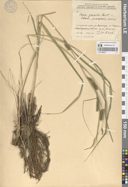
LE 01289233
Carex gracilis Curt. ⟨Осока режущая (резак)⟩ det. illegible at 23.07.1930
Collectors: illegible Collection date: 23.07.1930. Administrative regions: RU - Komi - Ust'-Vymskiy Rayon. Subregion: муниципальное образование Айкино. Топоним: Вычегда, река среднее течение. Place of collection: село Вездинская (деревня Вёздино), у озера Виччиаты.Expedition: Геоботаническая экспедиция Областного земельного управления, под руководством А. П. Шенникова ()Groups of specimens: Образцы сектора Восточной Европы; Соглашение Минобрнауки №075-15-2021-1056; Флора области Коми.Original label text:Устьвымский район, река Вычегда, село Вездинская Левобережная пойма у озера "Виччиаты"
Landscape in location of collection: средняя тайгаHabitat / plant community in location of collecting: левобережная поймаRecord creation: 2024-06-06, PhotoScan D2.. Processing status: label contains unreadable dataCitation: Specimen LE 01289233 // Virtual herbarium of Komarov Botanical Institute RAS — http://re.herbariumle.ru/01289233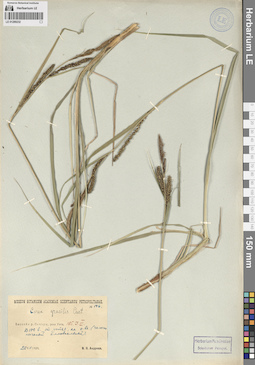
LE 01289232
Carex gracilis Curt. det. Andreev, Vladimir Nikolaevich at 22.07.1929
Collectors: Andreev, Vladimir Nikolaevich Field collecting number: 146. Collection date: 22.07.1929. Administrative regions: RU - Komi - Ukhta (gorodskoj okrug). Топоним: Ухта (река в Республике Коми, левый приток реки Ижмы (бассейн Печоры)). Place of collection: в 100 верстах от устья реки Ухта.Groups of specimens: Образцы сектора Восточной Европы; Соглашение Минобрнауки №075-15-2021-1056; Herbarium Academiae Scientiarum Petropol.; Museum Botanicum Academiae Scientiarum PetropolitanaeOriginal label text:Бассейн реки Печоры, река Ухта. 105.J.3. В 100 верстах от устья, на острове (галечно песчаный аллювиальный).
Landscape in location of collection: северная тайгаHabitat / plant community in location of collecting: на острове, галечно-песчаный аллювиальныйSubstrate in collecting location: pebble-sandy alluviumRecord creation: 2024-06-06, PhotoScan D2.Citation: Specimen LE 01289232 // Virtual herbarium of Komarov Botanical Institute RAS — http://re.herbariumle.ru/01289232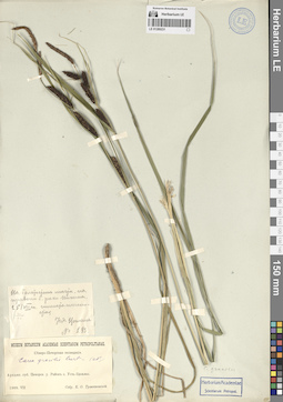
LE 01289231
Carex gracilis Curt. ⟮s. str.⟯ det. Trzheskovsky, K.O. at 25.07.1909
Collectors: Trzheskovsky, K.O. Field collecting number: 233. Collection date: 25.07.1909. Administrative regions: RU - Komi - Ust'-Tsilemskiy Rayon. Subregion: муниципальное образование Коровий Ручей. Топоним: Печорская Пижма (река) - нижнее течение. Place of collection: район села Усть-Цильма.Expedition: Северо-Печорская экспедиция 1909 г. (1909)Groups of specimens: Образцы сектора Восточной Европы; Соглашение Минобрнауки №075-15-2021-1056; Herbarium Academiae Scientiarum Petropol.; Museum Botanicum Academiae Scientiarum PetropolitanaeOriginal label text:Архангельская губерния, Печорский уезд Район села Усть-Цильмы. На болотистом месте, на правом берегу реки Пижмы глинисто-песчанистая Усть-Цыльма
Landscape in location of collection: северная тайгаHabitat / plant community in location of collecting: на болотистом месте, глинисто-песчанаяSubstrate in collecting location: sandy-argillaceousRecord creation: 2024-06-06, PhotoScan D2.Citation: Specimen LE 01289231 // Virtual herbarium of Komarov Botanical Institute RAS — http://re.herbariumle.ru/01289231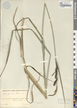
LE 01289230
Carex gracilis Curt. ⟮s. str.⟯ det. Durov, I. M. at 18.08.1911
Collectors: Durov, I. M. Collection date: 18.08.1911. Administrative regions: RU - Respublika Kareliya - Belomorskiy Rayon. Subregion: Беломорский муниципальный округ. Топоним: село Сумский Посад, Карелия. Place of collection: берег реки Сума.Groups of specimens: Образцы сектора Восточной Европы; Соглашение Минобрнауки №075-15-2021-1056; Herbarium Academiae Scientiarum Petropol.; Museum Botanicum Academiae Scientiarum PetropolitanaeOriginal label text:Архангельская губерния, Кемский уезд Сумской Посад Берег реки Сумы.
Landscape in location of collection: лесотундраRecord creation: 2024-06-06, PhotoScan D2.Citation: Specimen LE 01289230 // Virtual herbarium of Komarov Botanical Institute RAS — http://re.herbariumle.ru/01289230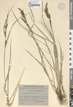
LE 01289229
Carex gracilis Curt. det. Dilis, Nikolai Vladislavovich at 07.07.1934
Collectors: Dilis, Nikolai Vladislavovich Field collecting number: 91/9. Collection date: 07.07.1934. Administrative regions: RU - Komi - Knyazhpogostskiy Rayon. Subregion: Княжпогостский муниципальный округ. Топоним: Ёлва — река в Республике Коми. (Елва Вымская).. Place of collection: Елвинские луга.Expedition: Печорская геоботаническая экспедиция Ботан. Института Академии Наук СССР под руковод. проф. А. П. Шенникова ()Groups of specimens: Образцы сектора Восточной Европы; Соглашение Минобрнауки №075-15-2021-1056; Herbarium Instituti Botanici Acad. Sc. URSSOriginal label text:Область Коми. Бассейн реки Выми. Елвинские луга. Основание склонов поймы реки Елвы, занятые осочником.
Landscape in location of collection: северная тайгаHabitat / plant community in location of collecting: основание склонов поймы, занятые осочникомRecord creation: 2024-06-06, PhotoScan D2.Citation: Specimen LE 01289229 // Virtual herbarium of Komarov Botanical Institute RAS — http://re.herbariumle.ru/01289229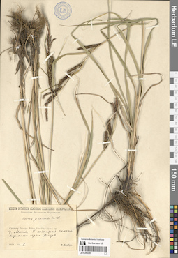
LE 01289228
Carex gracilis Curt. det. Sambuk, Feodosij Viktorovich at 08.08.1928
Collectors: Sambuk, Feodosij Viktorovich Collection date: 08.08.1928. Administrative regions: RU - Komi - Usinsk (gorodskoj okrug). Топоним: река Миня-Вож, приток реки Лыжа, бассейн реки Печора. Place of collection: деревня Миня (на карте отсутствует).Expedition: Печорская Экспедиция Наркомзема (1927)Groups of specimens: Образцы сектора Восточной Европы; Соглашение Минобрнауки №075-15-2021-1056; Museum Botanicum Academiae Scientiarum PetropolitanaeOriginal label text:Средняя Печора. Район Усть-Уса - Щелья юр. деревня Миня. У подножья склона коренного берега Печоры
Landscape in location of collection: северная тайгаHabitat / plant community in location of collecting: у подножья склона коренного берегаRecord creation: 2024-06-06, PhotoScan D2.Citation: Specimen LE 01289228 // Virtual herbarium of Komarov Botanical Institute RAS — http://re.herbariumle.ru/01289228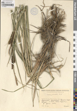
LE 01289227
Carex gracilis Curt. det. Sambuk, Feodosij Viktorovich at 10.08.1928
Collectors: Sambuk, Feodosij Viktorovich Collection date: 10.08.1928. Administrative regions: RU - Komi - Usinsk (gorodskoj okrug). Топоним: Мутный Материк, село в Городском округе Усинск Республики Коми.. Place of collection: правый берег реки Печора в 10 километрах от села Мутный Материк.Expedition: Печорская Экспедиция Наркомзема (1927)Groups of specimens: Образцы сектора Восточной Европы; Соглашение Минобрнауки №075-15-2021-1056; Museum Botanicum Academiae Scientiarum PetropolitanaeOriginal label text:Средняя Печора. Район Усть-Уса - Щелья юр. Мутный материк. Правый берег Печоры в 10 километрах выше деревни. У уреза воды.
Landscape in location of collection: граница лесотундры и северной тайгиHabitat / plant community in location of collecting: у уреза водыRecord creation: 2024-06-06, PhotoScan D2.Citation: Specimen LE 01289227 // Virtual herbarium of Komarov Botanical Institute RAS — http://re.herbariumle.ru/01289227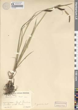
LE 01289226
Carex gracilis Curt. ⟮s. str.⟯ det. Zhuravskij, Andrej Vladimirovich at 19.07.1908
Collectors: Zhuravskij, Andrej Vladimirovich Collection date: 19.07.1908. Administrative regions: RU - Komi - Ust'-Tsilemskiy Rayon. Subregion: муниципальное образование Усть-Цильма. Топоним: Усть-Цильма, село в Республике Коми, Усть-Цилемский район. Groups of specimens: Образцы сектора Восточной Европы; Соглашение Минобрнауки №075-15-2021-1056; Herbarium Academiae Scientiarum Petropol.; Museum Botanicum Academiae Scientiarum PetropolitanaeOriginal label text:Архангельская губерния, Печорский уезд Усть-Цильма Еловый лес. Пески
Landscape in location of collection: северная тайгаHabitat / plant community in location of collecting: еловый лес, пескиSubstrate in collecting location: sandRecord creation: 2024-06-06, PhotoScan D2.Citation: Specimen LE 01289226 // Virtual herbarium of Komarov Botanical Institute RAS — http://re.herbariumle.ru/01289226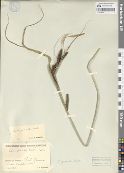
LE 01289225
Carex gracilis Curt. ⟮s. str.⟯ det. Zhuravskij, Andrej Vladimirovich at 15.07.1908
Collectors: Zhuravskij, Andrej Vladimirovich Collection date: 15.07.1908. Administrative regions: RU - Komi - Ust'-Tsilemskiy Rayon. Subregion: муниципальное образование Усть-Цильма. Топоним: Усть-Цильма, село в Республике Коми, Усть-Цилемский район. Groups of specimens: Образцы сектора Восточной Европы; Соглашение Минобрнауки №075-15-2021-1056; Herbarium Academiae Scientiarum Petropol.; Museum Botanicum Academiae Scientiarum PetropolitanaeOriginal label text:Архангельская губерния, Печорский уезд Усть-Цильма Пески. Еловый лес.
Landscape in location of collection: северная тайгаHabitat / plant community in location of collecting: пески, еловый лесSubstrate in collecting location: sandRecord creation: 2024-06-06, PhotoScan D2.Citation: Specimen LE 01289225 // Virtual herbarium of Komarov Botanical Institute RAS — http://re.herbariumle.ru/01289225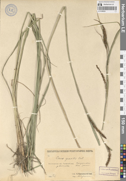
LE 01289224
Carex gracilis Curt. det. Korczagin, Alexander Aleksandrovich at 02.07.1926
Collectors: Korczagin, Alexander Aleksandrovich; Gaze, O. Field collecting number: 74. Collection date: 02.07.1926. Administrative regions: RU - Vologodskaya Oblast' - Totemskiy Rayon. Subregion: Тотемский муниципальный округ. Топоним: река Коченьга, приток реки Сухона. Expedition: Геоботаническая экспедиция Русского ботанического общества (1926)Groups of specimens: Образцы сектора Восточной Европы; Соглашение Минобрнауки №075-15-2021-1056; Herbarium Academiae Scientiarum Petropol.Original label text:Вологодская губерния, Тотемский уезд. река Коченьга Прирусловая зона реки
Landscape in location of collection: средняя тайгаHabitat / plant community in location of collecting: прирусловая зона рекиRecord creation: 2024-06-06, PhotoScan D2.Citation: Specimen LE 01289224 // Virtual herbarium of Komarov Botanical Institute RAS — http://re.herbariumle.ru/01289224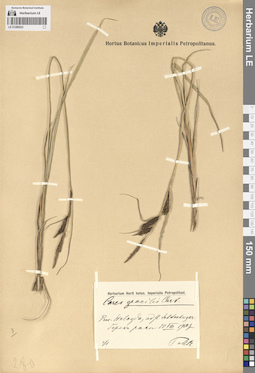
LE 01289223
Carex gracilis Curt. det. Pohle, Christian Nikolai Richard at 10.08.1907
Collectors: Pohle, Christian Nikolai Richard Collection date: 10.08.1907. Administrative regions: RU - Vologodskaya Oblast' - gorodskoy okrug Vologda; RU - Vologodskaya Oblast' - Vologodskiy Rayon. Топоним: река Шограш, приток реки Вологда. Place of collection: берег реки Шограш.Groups of specimens: Образцы сектора Восточной Европы; Соглашение Минобрнауки №075-15-2021-1056; Hortus Botanicus Imperialis Petropolitanus.; Herbarium Horti botan. Imperialis PetropolitaniOriginal label text:Provincium Wologda, ad flum. Schtukugor берег реки
Landscape in location of collection: южная тайгаRecord creation: 2024-06-06, PhotoScan D2.Citation: Specimen LE 01289223 // Virtual herbarium of Komarov Botanical Institute RAS — http://re.herbariumle.ru/01289223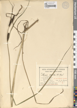
LE 01289222
Carex acuta L. det. Nyman, R. F. at 19.07.1903
Collectors: Nyman, R. F. Collection date: 19.07.1903. Administrative regions: RU - Arkhangel'skaya Oblast' - Primorskiy Rayon. Subregion: Приморский муниципальный округ. Топоним: Северная Двина, река (устье, дельта). Place of collection: остров Кегостров.Groups of specimens: Образцы сектора Восточной Европы; Соглашение Минобрнауки №075-15-2021-1056; Флора Архангельской губернии. Соловецкие острова и Кольский полуостров.Original label text:Кегостров при устье Северной Двины на заливных лугах
Landscape in location of collection: северная тайгаHabitat / plant community in location of collecting: на заливных лугахRecord creation: 2024-06-06, PhotoScan D2.Citation: Specimen LE 01289222 // Virtual herbarium of Komarov Botanical Institute RAS — http://re.herbariumle.ru/01289222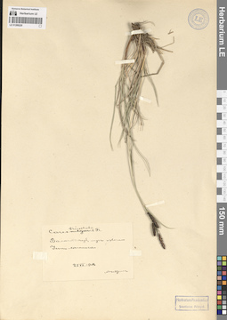
LE 01289220
Carex tricostata Fr. det. Andreev, Vladimir Nikolaevich at 25.06.1908
Collectors: Andreev, Vladimir Nikolaevich Collection date: 25.06.1908. Administrative regions: RU - Arkhangel'skaya Oblast' - Plesetskiy Rayon. Subregion: Плесецкий муниципальный округ. Топоним: река Соло, приток реки Пукса. Groups of specimens: Образцы сектора Восточной Европы; Соглашение Минобрнауки №075-15-2021-1056; Herbarium Academiae Scientiarum Petropol.Original label text:Вологодская губерния, луг от Соло Усть-Сысольски
Landscape in location of collection: средняя тайгаHabitat / plant community in location of collecting: лугRecord creation: 2024-06-06, PhotoScan D2.Citation: Specimen LE 01289220 // Virtual herbarium of Komarov Botanical Institute RAS — http://re.herbariumle.ru/01289220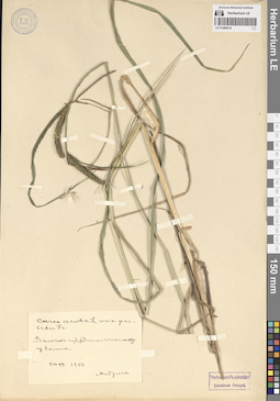
LE 01289219
Carex acuta L. var. prolixa det. Andreev, Vladimir Nikolaevich at 24.06.1908
Collectors: Andreev, Vladimir Nikolaevich Collection date: 24.06.1908. Administrative regions: RU - Komi. Groups of specimens: Образцы сектора Восточной Европы; Соглашение Минобрнауки №075-15-2021-1056; Herbarium Academiae Scientiarum Petropol.Original label text:Вологодская губерния, Усть-Сысольский уезд у болота
Landscape in location of collection: средняя тайгаHabitat / plant community in location of collecting: у болотаRecord creation: 2024-06-06, PhotoScan D2.Citation: Specimen LE 01289219 // Virtual herbarium of Komarov Botanical Institute RAS — http://re.herbariumle.ru/01289219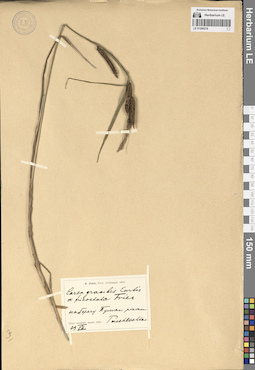
LE 01289218
Carex gracilis Curt. β tricostata Asch. det. Pohle, Christian Nikolai Richard at 23.07.1904
Collectors: Pohle, Christian Nikolai Richard Collection date: 23.07.1904. Administrative regions: RU - Arkhangel'skaya Oblast' - Primorskiy Rayon. Subregion: Приморский муниципальный округ. Топоним: Пушлахта — деревня Архангельской области.. Place of collection: на берегу реки Пушка.Groups of specimens: Образцы сектора Восточной Европы; Соглашение Минобрнауки №075-15-2021-1056; R. Pohle, Prov. Archangel, 1904Original label text:Litus orientale maris Albi: на берегу Пушки реки Puschlachta
Landscape in location of collection: северная тайгаRecord creation: 2024-06-06, PhotoScan D2.Citation: Specimen LE 01289218 // Virtual herbarium of Komarov Botanical Institute RAS — http://re.herbariumle.ru/01289218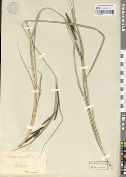
LE 01289217
Carex acuta L. det. Ivanitzky (Iwanizky), Nikolaj (Nikolai) Aleksandrovich
Collectors: Ivanitzky (Iwanizky), Nikolaj (Nikolai) Aleksandrovich Administrative regions: RU - Vologodskaya Oblast'; RU - Komi. Groups of specimens: Образцы сектора Восточной Европы; Соглашение Минобрнауки №075-15-2021-1056; Herbarium Academiae Scientiarum Petropol.Original label text:Wologda
Landscape in location of collection: средняя тайгаRecord creation: 2024-06-06, PhotoScan D2.Citation: Specimen LE 01289217 // Virtual herbarium of Komarov Botanical Institute RAS — http://re.herbariumle.ru/01289217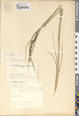
LE 01289216
Additional identifications: Carex acuta L. det. Korshinsky, Sergei Ivanovitsch at 18.06.1887; Carex gracilis Curt. det. Suchowa, Ju. D. at 1932 Collectors: Kusnezow, Nicolai Ivanovitch Field collecting number: 25. Collection date: 18.06.1887. Administrative regions: RU - Sverdlovskaya Oblast' - Ivdel'skiy gorodskoy okrug. Топоним: поселок Ушма, Ивдельский городской округ. Place of collection: по берегу реки Лозьва, выше поселка Ушма на 1,5 суток езды (по меркам 1887).Expedition: N. I. Kusnezow: Iter boreali-uralense. ()Groups of specimens: Образцы сектора Восточной Европы; Соглашение Минобрнауки №075-15-2021-1056; Н. И. Кузнецов. Растения Северного Урала 1887 г.Original label text:
Пермская губерния Верхотурский уезд Северный Урал. По берегу реки Лозьвы выше Ушмы на 1,5 суток езды. На лугах.
Landscape in location of collection: граница северной и средней тайгиHabitat / plant community in location of collecting: на лугахRecord creation: 2024-06-06, PhotoScan D2.Citation: Specimen LE 01289216 // Virtual herbarium of Komarov Botanical Institute RAS — http://re.herbariumle.ru/01289216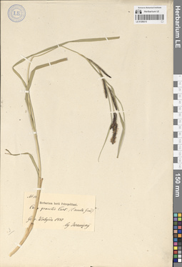
LE 01289215
Additional identifications: Carex gracilis Curt. det. Juanitzky, Juanizkij at 1880; Carex acuta L. det. Juanitzky, Juanizkij at 1880 Collectors: Juanitzky, Juanizkij Field collecting number: 12. Collection date: 1880. Administrative regions: RU - Vologodskaya Oblast'; RU - Komi. Groups of specimens: Образцы сектора Восточной Европы; Соглашение Минобрнауки №075-15-2021-1056; Herbarium horti PetropolitaniOriginal label text:
Gouvernement Wologda
Landscape in location of collection: средняя тайгаRecord creation: 2024-06-06, PhotoScan D2.Citation: Specimen LE 01289215 // Virtual herbarium of Komarov Botanical Institute RAS — http://re.herbariumle.ru/01289215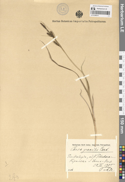
LE 01289214
Carex gracilis Curt. det. Pohle, Christian Nikolai Richard at 28.06.1905
Collectors: Pohle, Christian Nikolai Richard Collection date: 28.06.1905. Administrative regions: RU - Komi - Pechora (munitsipal'nyy rayon); RU - Komi - Vuktyl (gorodskoj okrug). Топоним: бассейн Печоры (Печора, Печӧра (коми-язык), река в Республике Коми и Ненецком автономном округе). Place of collection: между урочищем Корольки (Королек) и деревней Усть-Воя.Groups of specimens: Образцы сектора Восточной Европы; Соглашение Минобрнауки №075-15-2021-1056; Hortus Botanicus Imperialis Petropolitanus.; Herbarium Horti botan. Imperialis PetropolitaniOriginal label text:Provincium Wologda, ad flum. Petschoram Королек - Усть-Воя
Landscape in location of collection: северная тайгаRecord creation: 2024-06-06, PhotoScan D2.Citation: Specimen LE 01289214 // Virtual herbarium of Komarov Botanical Institute RAS — http://re.herbariumle.ru/01289214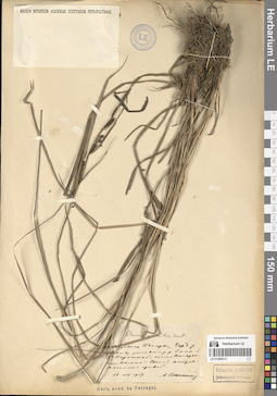
LE 01289213
Carex gracilis Curt. det. Schennikov, Alexander Petrovich at 16.08.1917
Collectors: Schennikov, Alexander Petrovich Collection date: 16.08.1917. Administrative regions: RU - Komi - Troitsko-Pechorskiy Rayon. Subregion: межселенные территории Троицко-Печорского муниципального района. Топоним: Унья (река, приток р. Печоры, Северный Урал, Республика Коми). Place of collection: между устьями рек Елма и Большая Порожная.Groups of specimens: Образцы сектора Восточной Европы; Соглашение Минобрнауки №075-15-2021-1056; Herbarium Academiae Scientiarum Petropol.; Museum Botanicum Academiae Scientiarum PetropolitanaeOriginal label text:В верховьях Печоры, Чердынский уезд Между устьями рек Елмы и Большой Порожной Речной остров Песчаный гравий.
Landscape in location of collection: средняя тайгаHabitat / plant community in location of collecting: речной остров, песчаный гравийSubstrate in collecting location: sandy gravelRecord creation: 2024-06-06, PhotoScan D2.Citation: Specimen LE 01289213 // Virtual herbarium of Komarov Botanical Institute RAS — http://re.herbariumle.ru/01289213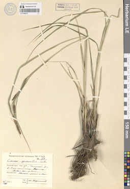
LE 01289212
Carex gracilis Curt. det. Kirpicznikov, Moisey Elevich at 02.07.1940
Collectors: Kirpicznikov, Moisey Elevich Field collecting number: 54. Collection date: 02.07.1940. Administrative regions: RU - Komi - Sosnogorskiy Rayon. Subregion: муниципальное образование Сосногорск. Топоним: Ижма река верхнее течение. Place of collection: правый берег реки Ижма, в 4 километрах ниже станции Подем-юр (Пожня).Expedition: Большеземельская экспедиция НКЗ РСФСР (1940)Groups of specimens: Образцы сектора Восточной Европы; Соглашение Минобрнауки №075-15-2021-1056; Herbarium Instituti Botanici Academiae Scientiarum URSS. Leningrad.Original label text:Печорский округ, Коми АССР Ухтинский район, в 4 километрах ниже станции Подем-юр Правый берег реки Ижмы. Местообитание Обильные заросли у воды.
Landscape in location of collection: средняя тайгаHabitat / plant community in location of collecting: обильные заросли у водыRecord creation: 2024-06-06, PhotoScan D2.Citation: Specimen LE 01289212 // Virtual herbarium of Komarov Botanical Institute RAS — http://re.herbariumle.ru/01289212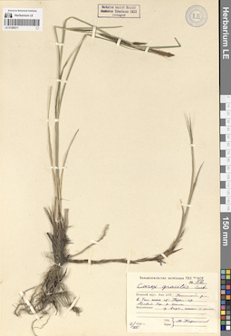
LE 01289211
Carex gracilis Curt. det. Kirpicznikov, Moisey Elevich at 02.07.1940
Collectors: Kirpicznikov, Moisey Elevich Field collecting number: 52. Collection date: 02.07.1940. Administrative regions: RU - Komi - Sosnogorskiy Rayon. Subregion: муниципальное образование Сосногорск. Топоним: Ижма река верхнее течение. Place of collection: правый берег реки Ижма, в 4 километрах ниже станции Подем-юр (Пожня).Expedition: Большеземельская экспедиция НКЗ РСФСР (1940)Groups of specimens: Образцы сектора Восточной Европы; Соглашение Минобрнауки №075-15-2021-1056; Herbarium Instituti Botanici Academiae Scientiarum URSS. Leningrad.Object features: часто и многоOriginal label text:Печорский округ, Коми АССР Ухтинский район, в 4 километрах ниже станции Подем-юр Правый берег реки Ижмы. Местообитание у воды, часто и много.
Landscape in location of collection: средняя тайгаHabitat / plant community in location of collecting: у водыRecord creation: 2024-06-06, PhotoScan D2.Citation: Specimen LE 01289211 // Virtual herbarium of Komarov Botanical Institute RAS — http://re.herbariumle.ru/01289211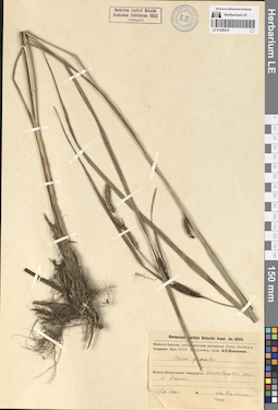
LE 01289210
Carex gracilis Curt. det. illegible at 01.09.1934
Collectors: illegible Collection date: 01.09.1934. Administrative regions: RU - Vologodskaya Oblast' - Cherepovetskiy Rayon. Subregion: сельское поселение Уломское. Топоним: озеро Язино, Череповецкий район. Place of collection: Молого-Шекснинское междуречье.Expedition: Волжско-Камская геоботаническая экспедиция Ботанического Института Академии Наук СССР под руководством проф. А.П. Шенникова (1939)Groups of specimens: Образцы сектора Восточной Европы; Соглашение Минобрнауки №075-15-2021-1056; Herbarium Instituti Botanici Academiae Scientiarum URSS. Leningrad.; Herbarium Instituti Botanici Acad. Sc. URSSOriginal label text:Молого-Шекснинское междуречье по сплавинам на озере Язино
Landscape in location of collection: южная тайгаHabitat / plant community in location of collecting: по сплавинам на озереRecord creation: 2024-06-06, PhotoScan D2.. Processing status: data is not fully enteredCitation: Specimen LE 01289210 // Virtual herbarium of Komarov Botanical Institute RAS — http://re.herbariumle.ru/01289210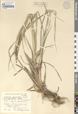
LE 01289209
Additional identifications: Carex gracilis Curt. det. Kirpicznikov, Moisey Elevich at 16.07.1940; Carex aquatilis Wahlenb. det. Kirpicznikov, Moisey Elevich at 16.07.1940 Collectors: Zemtsova, N. Field collecting number: 152. Collection date: 16.07.1940. Administrative regions: RU - Komi - Ust'-Tsilemskiy Rayon. Subregion: муниципальное образование Усть-Цильма. Топоним: река Валса, приток реки Мыла, бассейн реки Цильма. Place of collection: окрестности деревни Савинская.Expedition: Большеземельская экспедиция НКЗ РСФСР (1940)Groups of specimens: Образцы сектора Восточной Европы; Соглашение Минобрнауки №075-15-2021-1056; Herbarium Instituti Botanici Academiae Scientiarum URSS. Leningrad.Original label text:
Печорский округ, Коми АССР Усть-Цилемский район. Окрестности деревни Савинской Местообитание По каменистому берегу реки Валса около воды.
Landscape in location of collection: северная тайгаHabitat / plant community in location of collecting: по каменистому берегу реки, около водыSubstrate in collecting location: stoneRecord creation: 2024-06-06, PhotoScan D2.Citation: Specimen LE 01289209 // Virtual herbarium of Komarov Botanical Institute RAS — http://re.herbariumle.ru/01289209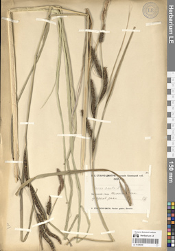
LE 01289208
Carex acuta L. det. Stantscho-Dmitri, V. S. at 01.07.1908
Collectors: Stantscho-Dmitri, V. S. Field collecting number: 529. Collection date: 01.07.1908. Administrative regions: RU - Vologodskaya Oblast' - Vytegorskiy Rayon. Subregion: сельское поселение Анненское. Топоним: село Анненский Мост (Шлюз святой Анны) (в месте слияния реки Ковжа с Мариинским каналом). Place of collection: у берегов реки Ковжа.Groups of specimens: Образцы сектора Восточной Европы; Соглашение Минобрнауки №075-15-2021-1056; В. С. Станчо-Дмитри: Растения Олонецкой губ. 1908 г.Original label text:Вытегорский уезд Шлюз святой Анны у берегов реки
Landscape in location of collection: средняя тайгаRecord creation: 2024-06-06, PhotoScan D2.Citation: Specimen LE 01289208 // Virtual herbarium of Komarov Botanical Institute RAS — http://re.herbariumle.ru/01289208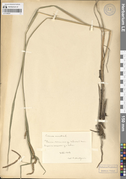
LE 01289207
Carex acuta L. det. Andreev, Vladimir Nikolaevich at 08.07.1908
Collectors: Andreev, Vladimir Nikolaevich Collection date: 08.07.1908. Administrative regions: RU - Komi - Syktyvdinskiy Rayon. Subregion: муниципальное образование Ыб. Топоним: Ыб — село в Сыктывдинском районе Республики Коми. Place of collection: у села Ыб.Groups of specimens: Образцы сектора Восточной Европы; Соглашение Минобрнауки №075-15-2021-1056; Herbarium Academiae Scientiarum Petropol.Original label text:Усть-Сысольского уезда Ибской волости берег озерка у села Иба
Landscape in location of collection: средняя тайгаHabitat / plant community in location of collecting: берег озеркаRecord creation: 2024-06-06, PhotoScan D2.Citation: Specimen LE 01289207 // Virtual herbarium of Komarov Botanical Institute RAS — http://re.herbariumle.ru/01289207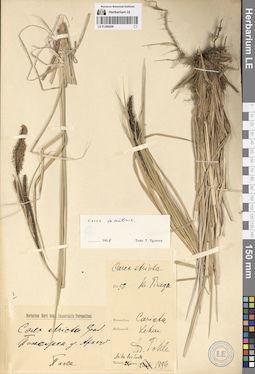
LE 01289206
Carex stricta Lam. det. Pohle, Christian Nikolai Richard at 21.06.1899
Collectors: Pohle, Christian Nikolai Richard Field collecting number: 50. Collection date: 21.06.1899. Administrative regions: RU - Arkhangel'skaya Oblast' - Pinezhskiy Rayon. Subregion: Пинежский муниципальный округ. Топоним: Пинега (река в Архангельской области России, правый приток Северной Двины). Groups of specimens: Образцы сектора Восточной Европы; Соглашение Минобрнауки №075-15-2021-1056; Herbarium Horti botan. Imperialis PetropolitaniOriginal label text:Пинежский уезд Архангельской губернии R. Pinega Formation Cariceta
Landscape in location of collection: тайгаHabitat / plant community in location of collecting: осоковое сообществоRecord creation: 2024-06-06, PhotoScan D2.Citation: Specimen LE 01289206 // Virtual herbarium of Komarov Botanical Institute RAS — http://re.herbariumle.ru/01289206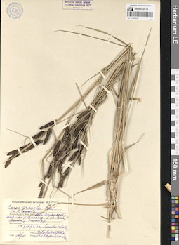
LE 01289205
Additional identifications: Carex gracilis Curt. det. Kirpicznikov, Moisey Elevich at 10.07.1940; Carex acuta L. det. Kirpicznikov, Moisey Elevich at 10.07.1940 Collectors: Lavrentyeva, M. Collection date: 10.07.1940. Administrative regions: RU - Komi - Ust'-Tsilemskiy Rayon. Subregion: муниципальное образование Трусово. Топоним: река Цильма, приток реки Печора, среднее течение. Place of collection: левый берег реки Цильма в 10-12 километрах выше деревни Нонбур (Нонбург).Expedition: Большеземельская экспедиция НКЗ РСФСР (1940)Groups of specimens: Образцы сектора Восточной Европы; Соглашение Минобрнауки №075-15-2021-1056; Ленинград. Ботанический институт Академии Наук СССР. Гербарий.Original label text:
Печорский округ, Коми АССР Усть-Цилемский район левый берег реки Цильмы в 10-12 километрах выше деревни Нонбур Местообитание 1 терраса, близко к воде
Landscape in location of collection: северная тайгаHabitat / plant community in location of collecting: 1 терраса, близко к водеRecord creation: 2024-06-06, PhotoScan D2.Citation: Specimen LE 01289205 // Virtual herbarium of Komarov Botanical Institute RAS — http://re.herbariumle.ru/01289205
LE 01289204
Carex acuta L. det. Pobedimova, Evgeniia Georgievna at 09.08.1958
Collectors: Pobedimova, Evgeniia Georgievna; Mordak, Elena Vladimirovna Field collecting number: 324. Collection date: 09.08.1958. Administrative regions: RU - Arkhangel'skaya Oblast' - Mezenskiy Rayon. Subregion: Мезенский муниципальный округ. Топоним: Сёмжа - деревня в Архангельской области. Place of collection: левый берег реки Сёмжа, за поселком Сёмжа.Groups of specimens: Образцы сектора Восточной Европы; Соглашение Минобрнауки №075-15-2021-1056; Ботанический институт им. В. Л. Комарова Академии наук СССРOriginal label text:Побережье Белого моря: Мезенская губа, левый берег реки Сёмжи, за посёлком Сёмжа, в лесу
Landscape in location of collection: лесотундраHabitat / plant community in location of collecting: в лесуRecord creation: 2024-06-06, PhotoScan D2.Citation: Specimen LE 01289204 // Virtual herbarium of Komarov Botanical Institute RAS — http://re.herbariumle.ru/01289204
LE 01289203
Carex acuta L. det. Lavrenko A. N., Ulle, Zinaida Georgievna at 10.07.1986
Collectors: Lavrenko A. N.; Ulle, Zinaida Georgievna Field collecting number: 431. Collection date: 10.07.1986. Administrative regions: RU - Komi - Troitsko-Pechorskiy Rayon. Subregion: межселенные территории Троицко-Печорского муниципального района. Топоним: река Кисунья, приток реки Унья, бассейн реки Печора. Place of collection: левый берег реки Кисунья, 12 километров к юго-восток-востоку от её впадения в реку Унья.Groups of specimens: Образцы сектора Восточной Европы; Соглашение Минобрнауки №075-15-2021-1056; Ленинград. Ботанический институт Академии Наук СССР. Гербарий.; Herbarium Filiae Komi Acad. Sci. URSS (SYKO)Original label text:Komi ASSR, Троицко-Печорский район, левый берег реки Кисуньи, 12 километров к юго-восток-востоку от её впадения в реку Унью, прибрежные осоковые заросли по песчано-галечниковым наносам.
Landscape in location of collection: граница северной и средней тайгиHabitat / plant community in location of collecting: прибрежные осоковые заросли по песчано-галечниковым наносамSubstrate in collecting location: sandy-pebble alluviumRecord creation: 2024-06-06, PhotoScan D2.Citation: Specimen LE 01289203 // Virtual herbarium of Komarov Botanical Institute RAS — http://re.herbariumle.ru/01289203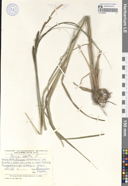
LE 01289202
Carex acuta L. det. Egorova, Tatiana Vladimirovna at 03.07.1973
Collectors: Vasilevich, Vladislav Ivanovich Collection date: 03.07.1973. Administrative regions: RU - Komi - Troitsko-Pechorskiy Rayon. Subregion: межселенные территории Троицко-Печорского муниципального района. Топоним: Илыч, река, верхнее течение. Place of collection: на берегу реки Илыч, близ устья реки Яран-Пасаёль.Groups of specimens: Образцы сектора Восточной Европы; Соглашение Минобрнауки №075-15-2021-1056; Гербарий Ботанического Института Академии наук СССРOriginal label text:Коми АССР, Троицко-Печорский район, верховья реки Илыч, близ устья реки Яран-Пасаёль. Разнотравный луг на берегу реки Илыч
Landscape in location of collection: граница северной и средней тайгиHabitat / plant community in location of collecting: разнотравный лугRecord creation: 2024-06-06, PhotoScan D2.Citation: Specimen LE 01289202 // Virtual herbarium of Komarov Botanical Institute RAS — http://re.herbariumle.ru/01289202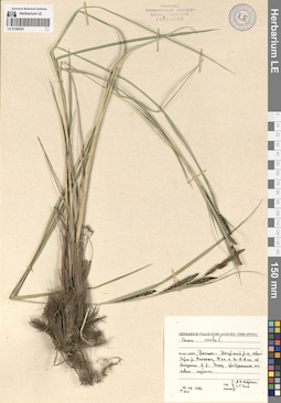
LE 01289201
Carex acuta L. det. Lavrenko A. N., Ulle, Zinaida Georgievna at 10.07.1986
Collectors: Lavrenko A. N.; Ulle, Zinaida Georgievna Field collecting number: 445. Collection date: 10.07.1986. Administrative regions: RU - Komi - Troitsko-Pechorskiy Rayon. Subregion: межселенные территории Троицко-Печорского муниципального района. Топоним: река Кисунья, приток реки Унья, бассейн реки Печора. Place of collection: левый берег реки Кисунья, 12 километров к юго-восток-востоку от её впадения в реку Унья.Groups of specimens: Образцы сектора Восточной Европы; Соглашение Минобрнауки №075-15-2021-1056; Ленинград. Ботанический институт Академии Наук СССР. Гербарий.; Herbarium Filiae Komi Acad. Sci. URSS (SYKO)Original label text:Komi ASSR, Троицко-Печорский район, левый берег реки Кисуньи, 12 километров к юго-восток-востоку от её впадения в реку Унью, прибрежные осоковые заросли.
Landscape in location of collection: средняя тайгаHabitat / plant community in location of collecting: прибрежные осоковые зарослиRecord creation: 2024-06-06, PhotoScan D2.Citation: Specimen LE 01289201 // Virtual herbarium of Komarov Botanical Institute RAS — http://re.herbariumle.ru/01289201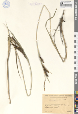
LE 01289200
Carex gracilis Curt. det. Sambuk, Feodosij Viktorovich at 10.08.1928
Collectors: Sambuk, Feodosij Viktorovich Collection date: 10.08.1928. Administrative regions: RU - Komi - Usinsk (gorodskoj okrug). Топоним: Мутный Материк, село в Городском округе Усинск Республики Коми.. Place of collection: берег реки Печора.Expedition: Печорская Экспедиция Наркомзема (1927)Groups of specimens: Образцы сектора Восточной Европы; Соглашение Минобрнауки №075-15-2021-1056; Ленинград. Ботанический институт Академии Наук СССР. Гербарий.; Museum Botanicum Academiae Scientiarum PetropolitanaeOriginal label text:Средняя Печора. Район Усть-Уса - Щелья юр. Мутный материк. У основания коренного берега.
Landscape in location of collection: граница лесотундры и северной тайгиHabitat / plant community in location of collecting: у основания коренного берегаRecord creation: 2024-06-06, PhotoScan D2.Citation: Specimen LE 01289200 // Virtual herbarium of Komarov Botanical Institute RAS — http://re.herbariumle.ru/01289200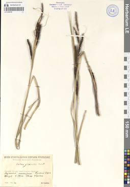
LE 01289199
Carex gracilis Curt. det. Sambuk, Feodosij Viktorovich at 10.08.1928
Collectors: Sambuk, Feodosij Viktorovich Collection date: 10.08.1928. Administrative regions: RU - Komi - Usinsk (gorodskoj okrug). Топоним: Мутный Материк, село в Городском округе Усинск Республики Коми.. Place of collection: правый берег реки Печора в 10 километрах от села Мутный Материк.Expedition: Печорская Экспедиция Наркомзема (1927)Groups of specimens: Образцы сектора Восточной Европы; Соглашение Минобрнауки №075-15-2021-1056; Ленинград. Ботанический институт Академии Наук СССР. Гербарий.; Museum Botanicum Academiae Scientiarum PetropolitanaeOriginal label text:Средняя Печора. Район Усть-Уса - Щелья юр. Мутный материк. Правый берег Печоры в 10 километрах выше деревни
Landscape in location of collection: граница лесотундры и северной тайгиRecord creation: 2024-06-06, PhotoScan D2.Citation: Specimen LE 01289199 // Virtual herbarium of Komarov Botanical Institute RAS — http://re.herbariumle.ru/01289199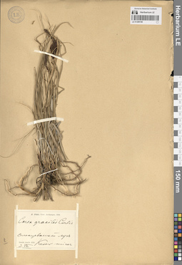
LE 01289198
Carex gracilis Curt. det. Pohle, Christian Nikolai Richard at 02.07.1904
Collectors: Pohle, Christian Nikolai Richard Collection date: 02.07.1904. Administrative regions: RU - Respublika Kareliya - Kemskiy Rayon. Subregion: Рабочеостровское сельское поселение. Топоним: остров Малый Кузов (Немецкий Кузов), Белое море. Groups of specimens: Образцы сектора Восточной Европы; Соглашение Минобрнауки №075-15-2021-1056; R. Pohle, Prov. Archangel, 1904Original label text:Insula maris Albi: Солонцеватый луг Kusow minor
Landscape in location of collection: островная тундра и лесотундраHabitat / plant community in location of collecting: солонцеватый лугRecord creation: 2024-06-06, PhotoScan D2.Citation: Specimen LE 01289198 // Virtual herbarium of Komarov Botanical Institute RAS — http://re.herbariumle.ru/01289198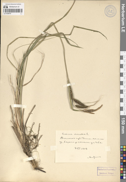
LE 01289197
Carex acuta L. det. Andreev, Vladimir Nikolaevich at 08.07.1908
Collectors: Andreev, Vladimir Nikolaevich Collection date: 08.07.1908. Administrative regions: RU - Komi - Syktyvdinskiy Rayon. Subregion: муниципальное образование Ыб. Топоним: Ыб — село в Сыктывдинском районе Республики Коми. Place of collection: берег реки Сысола у села Ыб.Groups of specimens: Образцы сектора Восточной Европы; Соглашение Минобрнауки №075-15-2021-1056; Herbarium Academiae Scientiarum Petropol.Original label text:Вологодская губерния Усть-Сысольский уезд берег реки Сысолы у села Иба
Landscape in location of collection: средняя тайгаRecord creation: 2024-06-06, PhotoScan D2.Citation: Specimen LE 01289197 // Virtual herbarium of Komarov Botanical Institute RAS — http://re.herbariumle.ru/01289197