View
Add
Copy
Edit
Delete
LE 01283633
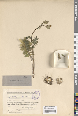
Specimen authenticum of Cephalorrhynchus kirpicznikovii Grossh. det. illegible at 08.1948
Collectors: Grossheim, Alexander Alfonsovich; Iljinskaja, Irina Alekseevna; Kirpicznikov, Moisey Elevich Collection date: 11.05.1947. Administrative regions: AZ - Nakhchivan Autonomous Republic. Топоним: гора Тандеры. Place of collection: отроги горы Тандеры, близ Арпачая.Expedition: Нахичеванская флористическая экспедиция-1947 ()Groups of specimens: Образцы сектора Кавказа; Соглашение Минобрнауки №075-15-2021-1056; Stephen Sommier - Plantae in Caucaso LectaeOriginal label text:Азербайджан, Нахичеванская АССР, Норашенский район, отроги горы Тандеры близ Арпа-чая. Около 900 метров Каменистые лужайки у скал.
Landscape in location of collection: горыHabitat / plant community in location of collecting: на каменистых лужайках у скалRecord creation: 2024-05-30, PhotoScan D2.Citation: Specimen LE 01283633 // Virtual herbarium of Komarov Botanical Institute RAS — http://re.herbariumle.ru/01283633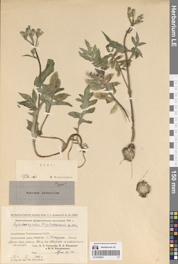
LE 01283632
Additional identifications: Specimen authenticum of Cephalorrhynchus kirpicznikovii Grossh. det. illegible at 08.1948; Type of Cephalorrhynchus kirpicznikovii Grossh. det. Kirpicznikov, Moisey Elevich at 27.04.1961 Collectors: Grossheim, Alexander Alfonsovich; Iljinskaja, Irina Alekseevna; Kirpicznikov, Moisey Elevich Collection date: 11.05.1947. Administrative regions: AZ - Nakhchivan Autonomous Republic. Топоним: гора Тандеры. Place of collection: отроги горы Тандеры, близ Арпачая.Expedition: Нахичеванская флористическая экспедиция-1947 ()Groups of specimens: Образцы сектора Кавказа; Соглашение Минобрнауки №075-15-2021-1056; Herbarium Instituti Botanici nomine V. L. Komarovii Academiae Sc. URSSOriginal label text:
Азербайджан, Нахичеванская АССР, Норашенский район, отроги горы Тандеры близ Арпа-чая, около 900 метров, на северных каменистых склонах.
Landscape in location of collection: горыHabitat / plant community in location of collecting: на северных каменистых склонахCoordinates (geographic position): 0° 0′ 0″ N, 0° 0′ 0″ E 900 m a.s.l.Record creation: 2024-05-30, PhotoScan D2.Citation: Specimen LE 01283632 // Virtual herbarium of Komarov Botanical Institute RAS — http://re.herbariumle.ru/01283632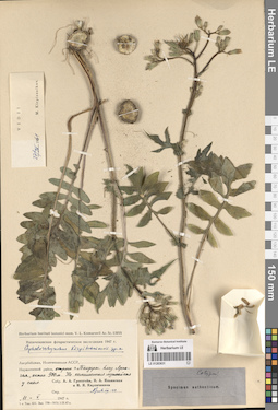
LE 01283631
Additional identifications: Specimen authenticum of Cephalorrhynchus kirpicznikovii Grossh. det. illegible at 08.1948; Type of Cephalorrhynchus kirpicznikovii Grossh. det. Kirpicznikov, Moisey Elevich at 27.04.1961 Collectors: Grossheim, Alexander Alfonsovich; Iljinskaja, Irina Alekseevna; Kirpicznikov, Moisey Elevich Collection date: 11.05.1947. Administrative regions: AZ - Nakhchivan Autonomous Republic. Топоним: гора Тандеры. Place of collection: отроги горы Тандеры, близ Арпачая.Expedition: Нахичеванская флористическая экспедиция-1947 ()Groups of specimens: Образцы сектора Кавказа; Соглашение Минобрнауки №075-15-2021-1056; Herbarium Instituti Botanici nomine V. L. Komarovii Academiae Sc. URSSOriginal label text:
Азербайджан, Нахичеванская АССР, Норашенский район, отроги горы Тандеры близ Арпа-чая, около 900 метров На каменистых лужайках у скал.
Landscape in location of collection: горыHabitat / plant community in location of collecting: на каменистых лужайках у скалCoordinates (geographic position): 900 m a.s.l.Record creation: 2024-05-30, PhotoScan D2.. Processing status: data is not fully enteredCitation: Specimen LE 01283631 // Virtual herbarium of Komarov Botanical Institute RAS — http://re.herbariumle.ru/01283631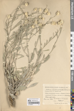
LE 01283630
Centaurea xanthocephaloides Tzvelev det. Tzvelev, Nikolai Nikolaievich at 08.07.1957
Collectors: Tzvelev, Nikolai Nikolaievich; Czerepanov, Sergei Kirillovich Field collecting number: 775. Collection date: 08.07.1957. Administrative regions: AM - Armenia. Топоним: село Ортакенд (современное название не известно). Place of collection: в 3-4 километрах к северо-западу от села Ортакенд.Groups of specimens: Образцы сектора Кавказа; Соглашение Минобрнауки №075-15-2021-1056; Herbarium Instituti Botanici Academiae Sc. URSSOriginal label text:Армянская ССР. Район Микояновский Осыпь гипсоносной глины с выходами соленых источников в 3-4 километрах к северо-западу от села Ортакенд. Нижний горный пояс
Landscape in location of collection: нижний горный поясHabitat / plant community in location of collecting: осыпь гипсоносной глины с выходами соленых источниковRecord creation: 2024-05-30, PhotoScan D2.Citation: Specimen LE 01283630 // Virtual herbarium of Komarov Botanical Institute RAS — http://re.herbariumle.ru/01283630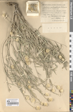
LE 01283629
Type of Centaurea xanthocephaloides Tzvelev det. Tzvelev, Nikolai Nikolaievich at 08.07.1957
Collectors: Tzvelev, Nikolai Nikolaievich; Czerepanov, Sergei Kirillovich Field collecting number: 775. Collection date: 08.07.1957. Administrative regions: AM - Armenia. Топоним: село Ортакенд (современное название не известно). Place of collection: в 3-4 километрах к северо-западу от села Ортакенд.Groups of specimens: Образцы сектора Кавказа; Соглашение Минобрнауки №075-15-2021-1056; Herbarium Instituti Botanici Academiae Sc. URSSOriginal label text:Армянская ССР. Район Микояновский Осыпь гипсоносной глины с выходами соленых источников в 3-4 километрах к северо-западу от села Ортакенд. Нижний горный пояс
Landscape in location of collection: нижний горный поясHabitat / plant community in location of collecting: осыпь гипсоносной глины с выходами соленых источниковRecord creation: 2024-05-30, PhotoScan D2.Citation: Specimen LE 01283629 // Virtual herbarium of Komarov Botanical Institute RAS — http://re.herbariumle.ru/01283629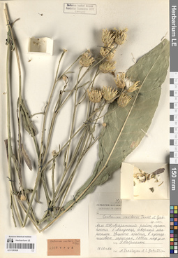
LE 01283628
Isotype of Centaurea vavilovii Takht. & Gabrieljan det. Gabrieljan, Elenora Tzolakovna, Takhtajan, Armen Leonovich at 18.08.1986
Collectors: Gabrieljan, Elenora Tzolakovna Collection date: 18.08.1986. Administrative regions: AM - Ararati Marz - Ararat K'aghak. Топоним: село Ланджар. Place of collection: окрестности села Ланджар, северный макросклон Урцского хребта.Groups of specimens: Образцы сектора Кавказа; Соглашение Минобрнауки №075-15-2021-1056; Гербарий Ботанического института Академии наук Армянской ССРOriginal label text:Армянская ССР, Араратский район, окрестности села Ланджер, северный макросклон Урцского хребта, в кустарниковых зарослях, 1850 метров над уровнем моря
Landscape in location of collection: горыHabitat / plant community in location of collecting: в кустарниковых заросляхRecord creation: 2024-05-30, PhotoScan D2.Citation: Specimen LE 01283628 // Virtual herbarium of Komarov Botanical Institute RAS — http://re.herbariumle.ru/01283628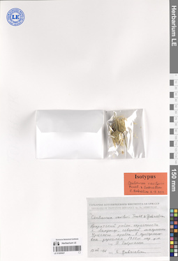
LE 01283627
Additional identifications: Centaurea vavilovii Takht. & Gabrieljan det. Gabrieljan, Elenora Tzolakovna at 18.08.1986; Isotype of Centaurea vavilovii Takht. & Gabrieljan det. Gabrieljan, Elenora Tzolakovna at 16.12.2014 Collectors: Gabrieljan, Elenora Tzolakovna Collection date: 18.08.1986. Administrative regions: AM - Ararati Marz - Ararat K'aghak. Топоним: село Ланджар. Place of collection: окрестности села Ланджар, северный макросклон Урцского хребта.Groups of specimens: Образцы сектора Кавказа; Соглашение Минобрнауки №075-15-2021-1056; Гербарий Ботанического института Академии наук Армянской ССРOriginal label text:
Араратский район, окрестности села Ланджер, северный макросклон Урцского хребта, в кустарниковых зарослях, 1850 метров над уровнем моря
Landscape in location of collection: горыHabitat / plant community in location of collecting: в кустарниковых заросляхRecord creation: 2024-05-30, PhotoScan D2.Citation: Specimen LE 01283627 // Virtual herbarium of Komarov Botanical Institute RAS — http://re.herbariumle.ru/01283627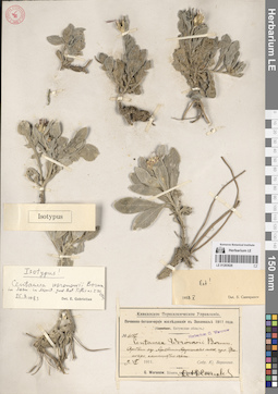
LE 01283626
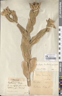
Additional identifications: Centaurea woronovii Bornm. ex Sosn. det. Woronov, Jurij (Georg) Nikolaewich at 09.07.1911; Centaurea woronovii Bornm. ex Sosn. det. Czerepanov, Sergei Kirillovich at 05.1958; Isotype of Centaurea woronovii Bornm. ex Sosn. det. Gabrieljan, Elenora Tzolakovna at 25.08.1983 Collectors: Woronov, Jurij (Georg) Nikolaewich Field collecting number: 6187. Collection date: 09.07.1911. Administrative regions: GE - Ajaria; TR - Turkey. Топоним: урочище Цхалокро. Place of collection: Артвинские окрестности, Артвино-Ардагонское шоссе.Expedition: Кавказское переселенческое управление. Почвенно-ботанические исследования в Закавказье-1911. Батумская область. ()Groups of specimens: Образцы сектора Кавказа; Соглашение Минобрнауки №075-15-2021-1056; Herbarium G. WoronowOriginal label text:
Артвинские окрестности Артвино-Ардагонское шоссе, урочище Цхалокро, каменистые осыпи.
Landscape in location of collection: теплоумеренные смешанные (влажные) лесаHabitat / plant community in location of collecting: каменистые осыпиRecord creation: 2024-05-30, PhotoScan D2.Citation: Specimen LE 01283626 // Virtual herbarium of Komarov Botanical Institute RAS — http://re.herbariumle.ru/01283626
LE 01283625
Additional identifications: Centaurea fischeri Schltdl. var. purpurea (DC.) Sosnowsky det. Busch, Elizaveta Aleksandrovna, Busch, Nikolai Adolfovich (Nikolaj Adolfowitsch) at 07.08.1931; Type of Centaurea willdenowii Czerep. det. Czerepanov, Sergei Kirillovich at 06.1958 Collectors: Busch, Elizaveta Aleksandrovna; Busch, Nikolai Adolfovich (Nikolaj Adolfowitsch) Collection date: 07.08.1931. Administrative regions: RU - Kabardino-Balkarskaya Respublika. Топоним: река Туяла, Кабардино-Балкария. Place of collection: Хызны, близ устья реки Туяла.Expedition: Балкарская экспедиция Академии наук СССР ()Groups of specimens: Образцы сектора Кавказа; Соглашение Минобрнауки №075-15-2021-1056Original label text:
Хызны, дно долины. близ устья Туяла 200 метров
Landscape in location of collection: горыHabitat / plant community in location of collecting: дно долиныCoordinates (geographic position): 2000 m a.s.l.Record creation: 2024-05-30, PhotoScan D2.Citation: Specimen LE 01283625 // Virtual herbarium of Komarov Botanical Institute RAS — http://re.herbariumle.ru/01283625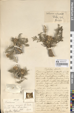
LE 01283624
Additional identifications: Psephellus restulatus det. Szovits (Szowitz, Szovitz), Johann Nepomuk at 12.04.1828; Centaurea sp. det. Szovits (Szowitz, Szovitz), Johann Nepomuk at 12.04.1828; Type of Centaurea restulata DC. det. Sosnowsky, Dmitry Ivanovich at 1948 Collectors: Szovits (Szowitz, Szovitz), Johann Nepomuk Field collecting number: 93. Collection date: 12.04.1828. Groups of specimens: Образцы сектора Кавказа; Соглашение Минобрнауки №075-15-2021-1056Record creation: 2024-05-30, PhotoScan D2.Citation: Specimen LE 01283624 // Virtual herbarium of Komarov Botanical Institute RAS — http://re.herbariumle.ru/01283624
LE 01283623
Additional identifications: Psephellus restulatus det. Szovits (Szowitz, Szovitz), Johann Nepomuk; Type of Centaurea restulata DC. det. Sosnowsky, Dmitry Ivanovich at 1948 Collectors: Szovits (Szowitz, Szovitz), Johann Nepomuk Field collecting number: 9. Administrative regions: AZ - Azerbaijan. Топоним: город Ормях (современное название не известно). Place of collection: вокруг города Ормях.Groups of specimens: Образцы сектора Кавказа; Соглашение Минобрнауки №075-15-2021-1056; Herb. LedebourOriginal label text:
In collibus calcareis circa urbem Ormiah prov. Aderbaidschan
Landscape in location of collection: горыHabitat / plant community in location of collecting: на известняковых холмахSubstrate in collecting location: limestoneRecord creation: 2024-05-30, PhotoScan D2.Citation: Specimen LE 01283623 // Virtual herbarium of Komarov Botanical Institute RAS — http://re.herbariumle.ru/01283623
LE 01283622
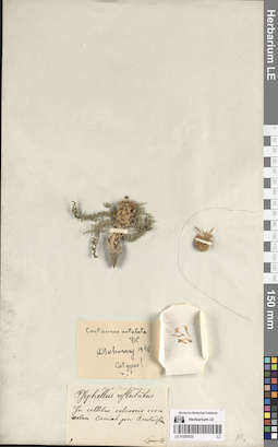
Type of Centaurea tuba S. S. det. Sommier, Carlo Pietro Stefano(Stephen) at 01.08.1890
Collectors: Sommier, Carlo Pietro Stefano(Stephen) Field collecting number: 785. Collection date: 01.08.1890. Administrative regions: GE - Racha-Lechkhumi and Kvemo Svaneti. Groups of specimens: Образцы сектора Кавказа; Соглашение Минобрнауки №075-15-2021-1056; Stephen Sommier - Plantae in Caucaso LectaeOriginal label text:Svanetia ..., prope arborum limites, 2100 m.
Landscape in location of collection: горыHabitat / plant community in location of collecting: у края лесаCoordinates (geographic position): 2100 m a.s.l.Record creation: 2024-05-30, PhotoScan D2.. Processing status: label contains unreadable dataCitation: Specimen LE 01283622 // Virtual herbarium of Komarov Botanical Institute RAS — http://re.herbariumle.ru/01283622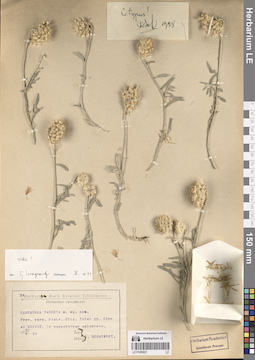
LE 01283621
Additional identifications: Centaurea taochia (Sosn.) Sosn. det. Sosnowsky, Dmitry Ivanovich at 20.05.1912; Centaurea taochia (Sosn.) Sosn. det. Wogeniz, G. at 03.1971 Collectors: Sosnowsky, Dmitry Ivanovich Collection date: 20.05.1912. Administrative regions: TR - Turkey. Subregion: провинция (ил) Эрзурум. Топоним: город Олту. Place of collection: между селами Олор и Норпет.Groups of specimens: Образцы сектора Кавказа; Соглашение Минобрнауки №075-15-2021-1056; Herbarium Horti Botanici Tiflisiensis. Herbarium caucasicum.Original label text:
Provincium Kars. Districtum Olty. Inter pag. Olor et NORPET, in rupestribus calcareis.
Landscape in location of collection: горыHabitat / plant community in location of collecting: на известняковых скалахSubstrate in collecting location: limestoneRecord creation: 2024-05-30, PhotoScan D2.Citation: Specimen LE 01283621 // Virtual herbarium of Komarov Botanical Institute RAS — http://re.herbariumle.ru/01283621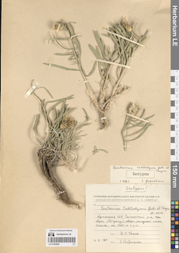
LE 01283620
Additional identifications: Centaurea takhtajanii Gabrieljan & Tonjan det. Gabrieljan, Elenora Tzolakovna at 10.08.1969; Isotype of Centaurea takhtajanii Gabrieljan & Tonjan det. Gabrieljan, Elenora Tzolakovna at 01.04.1984 Collectors: Tonjan, Zogik Rubenovna Collection date: 10.08.1969. Administrative regions: AM - Aragatsotni Marz - T'alini Shrjan. Топоним: гора Арег. Place of collection: северо-западный склон горы Арег (Богутлу).Groups of specimens: Образцы сектора Кавказа; Соглашение Минобрнауки №075-15-2021-1056Original label text:
Армянская ССР, Талинский район, гора Арег (Богутлу), северо-западный склон, скалы, около 1800 метров над уровнем моря
Landscape in location of collection: горыHabitat / plant community in location of collecting: скалыCoordinates (geographic position): 1800 m a.s.l.Record creation: 2024-05-30, PhotoScan D2.Citation: Specimen LE 01283620 // Virtual herbarium of Komarov Botanical Institute RAS — http://re.herbariumle.ru/01283620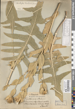
LE 01283619
Additional identifications: Centaurea behen L. det. Szovits (Szowitz, Szovitz), Johann Nepomuk at 01.07.1829; Type of Microlophus szovitsianus (Boiss.) Takht. det. Takhtajan, Armen Leonovich Collectors: Szovits (Szowitz, Szovitz), Johann Nepomuk Collection date: 01.07.1829. Groups of specimens: Образцы сектора Кавказа; Соглашение Минобрнауки №075-15-2021-1056; Ex herbario horti Petropolitani; Herbarium Academiae Scientiarum Petropol.Original label text:
In siccis lapidosis vallis Koschadara provincium Karadagh
Record creation: 2024-05-30, PhotoScan D2.Citation: Specimen LE 01283619 // Virtual herbarium of Komarov Botanical Institute RAS — http://re.herbariumle.ru/01283619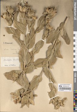
LE 01283618
Additional identifications: Centaurea szovitsiana Boiss. det. Lipsky, Vladimir Ippolitovich; Type of Microlophus szovitsianus (Boiss.) Takht. det. Takhtajan, Armen Leonovich Collectors: Busch Groups of specimens: Образцы сектора Кавказа; Соглашение Минобрнауки №075-15-2021-1056Record creation: 2024-05-30, PhotoScan D2.Citation: Specimen LE 01283618 // Virtual herbarium of Komarov Botanical Institute RAS — http://re.herbariumle.ru/01283618
LE 01283617
Additional identifications: Centaurea behen L. det. Szovits (Szowitz, Szovitz), Johann Nepomuk; Centaurea szovitsiana Boiss. det. Szovits (Szowitz, Szovitz), Johann Nepomuk; Centaurea behen L. det. Ledebour, Carl (Karl) Friedrich von [Ledebour]; Centaurea szovitsiana Boiss. det. Lipsky, Vladimir Ippolitovich; Type of Microlophus szovitsianus (Boiss.) Takht. det. Takhtajan, Armen Leonovich at 1949 Collectors: Szovits (Szowitz, Szovitz), Johann Nepomuk Administrative regions: AZ - Azerbaijan. Топоним: долина Кошадара. Place of collection: Карабах.Groups of specimens: Образцы сектора Кавказа; Соглашение Минобрнауки №075-15-2021-1056; Herb. LedebourOriginal label text:
In locis lapidosis siccis vallis Koschadara provincium Karabagh
Landscape in location of collection: горыRecord creation: 2024-05-30, PhotoScan D2.Citation: Specimen LE 01283617 // Virtual herbarium of Komarov Botanical Institute RAS — http://re.herbariumle.ru/01283617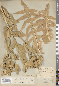
LE 01283616
Additional identifications: Centaurea behen L. det. Szovits (Szowitz, Szovitz), Johann Nepomuk; Type of Microlophus szovitsianus (Boiss.) Takht. det. Takhtajan, Armen Leonovich at 1949 Collectors: Szovits (Szowitz, Szovitz), Johann Nepomuk Administrative regions: AZ - Azerbaijan. Топоним: долина Кошадара. Place of collection: Карабах.Groups of specimens: Образцы сектора Кавказа; Соглашение Минобрнауки №075-15-2021-1056; Herbarium Academiae Scientiarum Petropol.; Herbarium of MeyerOriginal label text:
In locis lapidosis siccis vallis Koschadara provincium Karabagh
Landscape in location of collection: горыRecord creation: 2024-05-30, PhotoScan D2.Citation: Specimen LE 01283616 // Virtual herbarium of Komarov Botanical Institute RAS — http://re.herbariumle.ru/01283616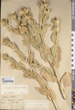
LE 01283615
Additional identifications: Centaurea behen L. det. Szovits (Szowitz, Szovitz), Johann Nepomuk; Type of Microlophus szovitsianus (Boiss.) Takht. det. Takhtajan, Armen Leonovich at 1949 Collectors: Szovits (Szowitz, Szovitz), Johann Nepomuk Administrative regions: AZ - Azerbaijan. Топоним: долина Кошадара. Place of collection: Карабах.Groups of specimens: Образцы сектора Кавказа; Соглашение Минобрнауки №075-15-2021-1056Original label text:
In locis lapidosis siccis vallis Koschadara provincium Karabagh
Landscape in location of collection: горыRecord creation: 2024-05-30, PhotoScan D2.Citation: Specimen LE 01283615 // Virtual herbarium of Komarov Botanical Institute RAS — http://re.herbariumle.ru/01283615
LE 01283614
Additional identifications: Centaurea sp. det. Wiedemann, Ferdinand Johann; Centaurea szovitsiana Boiss. det. Busch; Specimen authenticum of Microlophus szovitsianus (Boiss.) Takht. det. Takhtajan, Armen Leonovich at 1949 Collectors: Wiedemann, Ferdinand Johann Collection date: 12.07.1835. Administrative regions: TR - Turkey. Subregion: провинция (ил) Токат. Топоним: город Токат. Groups of specimens: Образцы сектора Кавказа; Соглашение Минобрнауки №075-15-2021-1056Original label text:
Tokat
Record creation: 2024-05-30, PhotoScan D2.Citation: Specimen LE 01283614 // Virtual herbarium of Komarov Botanical Institute RAS — http://re.herbariumle.ru/01283614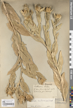
LE 01283613
Additional identifications: Centaurea behen L. det. Szovits (Szowitz, Szovitz), Johann Nepomuk; Type of Microlophus szovitsianus (Boiss.) Takht. det. Takhtajan, Armen Leonovich at 1949 Collectors: Szovits (Szowitz, Szovitz), Johann Nepomuk Administrative regions: AZ - Azerbaijan. Топоним: долина Кошадара. Place of collection: Карабах.Groups of specimens: Образцы сектора Кавказа; Соглашение Минобрнауки №075-15-2021-1056; Herbarium Academiae Scientiarum Petropol.Original label text:
In locis siccis lapidosis vallis Koschadara provincium Karabagh
Landscape in location of collection: горыRecord creation: 2024-05-30, PhotoScan D2.Citation: Specimen LE 01283613 // Virtual herbarium of Komarov Botanical Institute RAS — http://re.herbariumle.ru/01283613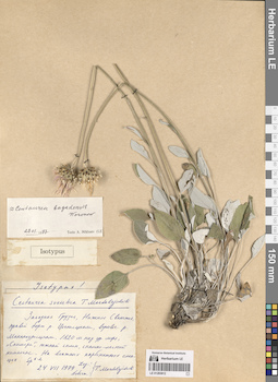
LE 01283612
Additional identifications: Isotype of Centaurea svanetica Mardal. det. Mardalejschvili, T.K. at 24.08.1979; Centaurea bagadensis Woronow ⟮prelim. ID⟯ det. Mikheev, Anatolij Dmitrievich at 29.01.1997 Collectors: Mardalejschvili, T.K. Collection date: 24.08.1979. Administrative regions: GE - Racha-Lechkhumi and Kvemo Svaneti. Топоним: река Мананаурисцнали. Place of collection: правый борт реки Цхенисцнали, верховье реки Мананаурисцнали, "Скимери", южный склон.Groups of specimens: Образцы сектора Кавказа; Соглашение Минобрнауки №075-15-2021-1056Original label text:
Западная Грузия, Нижняя Сванетия, правый борт реки Цхенисцнали, верховье реки Мананаурисцнали, 1820 метров над уровнем моря, "Скимери", южный склон, скально-лесной комплекс. На влажных карбонатных сланцах. Sp 1-2
Landscape in location of collection: горыHabitat / plant community in location of collecting: скально-лесной комплекс, на влажных карбонатных сланцахSubstrate in collecting location: carbonates, shaleCoordinates (geographic position): 1820 m a.s.l.Record creation: 2024-05-30, PhotoScan D2.Citation: Specimen LE 01283612 // Virtual herbarium of Komarov Botanical Institute RAS — http://re.herbariumle.ru/01283612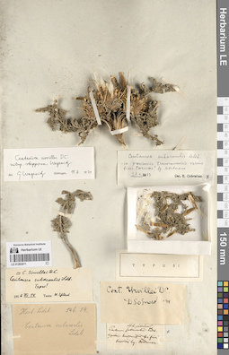
LE 01283611
Additional identifications: Centaurea subacaulis Ledeb. det. Ledebour, Carl (Karl) Friedrich von [Ledebour]; Centaurea urvillei DC. det. Sosnowsky, Dmitry Ivanovich at 1941; Centaurea urvillei DC. det. Tzvelev, Nikolai Nikolaievich at 14.12.1956; Centaurea subacaulis Ledeb. det. Tzvelev, Nikolai Nikolaievich at 14.12.1956; Centaurea urvillei DC. subsp. stepposa Wogeniz det. Wogeniz, G. at 19.03.1971; Type of Centaurea subacaulis Ledeb. det. Gabrieljan, Elenora Tzolakovna at 27.04.1987 Collectors: Nordmann, Alexander (Davidovič) von Field collecting number: 546.54. Groups of specimens: Образцы сектора Кавказа; Соглашение Минобрнауки №075-15-2021-1056; Herb. LedebourOriginal label text:
in provinciis transcaucasicis versus fines turcicas
Record creation: 2024-05-30, PhotoScan D2.Citation: Specimen LE 01283611 // Virtual herbarium of Komarov Botanical Institute RAS — http://re.herbariumle.ru/01283611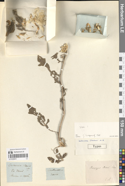
LE 01283610
Additional identifications: Centaurea stevenii Bieb. det. Steven, Christian von at 1806; Type of Centaurea stevenii Bieb. det. Wogeniz, G. at 1968 Collectors: Steven, Christian von Collection date: 1806. Groups of specimens: Образцы сектора Кавказа; Соглашение Минобрнауки №075-15-2021-1056Record creation: 2024-05-30, PhotoScan D2.Citation: Specimen LE 01283610 // Virtual herbarium of Komarov Botanical Institute RAS — http://re.herbariumle.ru/01283610
LE 01283609
Additional identifications: Centaurea stevenii Bieb. det. Busch; Specimen authenticum of Centaurea stevenii Bieb. det. Gabrieljan, Elenora Tzolakovna at 1987 Collectors: Busch Groups of specimens: Образцы сектора Кавказа; Соглашение Минобрнауки №075-15-2021-1056Comment:
Specimen authenticum
Record creation: 2024-05-30, PhotoScan D2.Citation: Specimen LE 01283609 // Virtual herbarium of Komarov Botanical Institute RAS — http://re.herbariumle.ru/01283609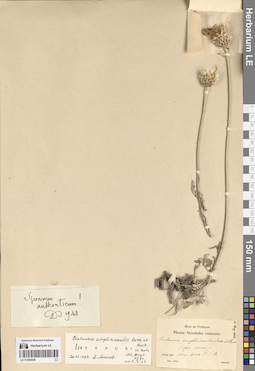
LE 01283608
Additional identifications: Specimen authenticum of Centaurea simplicicaulis Boiss. & Huet det. Huet du Pavillion at 06.1853; Type of Centaurea simplicicaulis Boiss. & Huet det. Mikheev, Anatolij Dmitrievich at 20.03.1997 Collectors: Huet du Pavillion Collection date: 06.1853. Administrative regions: AM - Armenia. Groups of specimens: Образцы сектора Кавказа; Соглашение Минобрнауки №075-15-2021-1056; Huet du Pavillon. Plantae Orientales exiccatae.Original label text:
Armenia
Record creation: 2024-05-30, PhotoScan D2.Citation: Specimen LE 01283608 // Virtual herbarium of Komarov Botanical Institute RAS — http://re.herbariumle.ru/01283608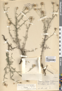
LE 01283607
Type of Centaurea sczipczinskyi Mikheev det. Mikheev, Anatolij Dmitrievich at 25.02.1997
Collectors: Galushko, Anatoli Ivanovich Collection date: 15.08.1964. Administrative regions: RU - Stavropol'skiy Kray. Subregion: городской округ город-курорт Кисловодск. Топоним: гора Кольцо. Place of collection: окрестности (окраина) города Кисловодск.Groups of specimens: Образцы сектора Кавказа; Соглашение Минобрнауки №075-15-2021-1056Original label text:Северный Кавказ, Ставропольский край, окрестности города Кисловодск, гора Кольцо
Landscape in location of collection: горыRecord creation: 2024-05-30, PhotoScan D2.Citation: Specimen LE 01283607 // Virtual herbarium of Komarov Botanical Institute RAS — http://re.herbariumle.ru/01283607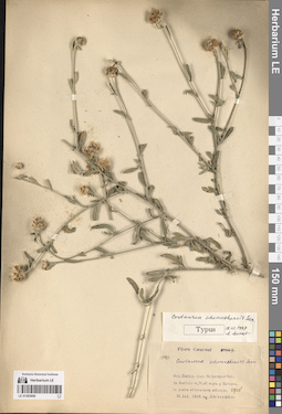
LE 01283606
Additional identifications: Centaurea schemakhensis Sosn. det. Busch; Type of Centaurea schemakhensis Sosn. det. Mikheev, Anatolij Dmitrievich at 18.02.1997 Collectors: Alexeenko, Fyodor Nikitich Collection date: 31.07.1900. Administrative regions: AZ - Quba Rayon. Топоним: Зарнова (Заргова). Place of collection: гора Ниджаль (Ниджал?) над селом Заргова.Groups of specimens: Образцы сектора Кавказа; Соглашение Минобрнауки №075-15-2021-1056; Flora CaucasicaOriginal label text:
Gubernium Baku. Districtum Schemacha. In decliviis m. Nijal supra pag. Zarnova. In pratis ad terminem arborum.
Landscape in location of collection: теплоумеренный пояс, граница предгорных степей и смешанных (влажных) лесовHabitat / plant community in location of collecting: луг на краю лесаRecord creation: 2024-05-30, PhotoScan D2.Citation: Specimen LE 01283606 // Virtual herbarium of Komarov Botanical Institute RAS — http://re.herbariumle.ru/01283606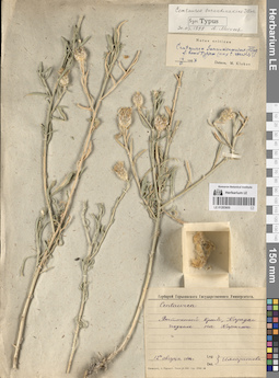
LE 01283605
Additional identifications: Centaurea sp. det. Illarionova, Nadezhda Borisovna at 12.08.1946; Centaurea sarandinakiae N.B. Illar. f. houdtypica ⟮prelim. ID⟯ det. Klokov, Michail Vasilijevich at 14.06.1957; Syntype of Centaurea sarandinakiae N.B. Illar. det. Mikheev, Anatolij Dmitrievich at 30.03.1998 Collectors: Illarionova, Nadezhda Borisovna Collection date: 12.08.1946. Administrative regions: RU - Republic of Crimea. Subregion: городской округ Феодосия. Топоним: Карадаг (Кара-Даг). Place of collection: подъем на гору Карагач.Groups of specimens: Образцы сектора Кавказа; Соглашение Минобрнауки №075-15-2021-1056; Гербарий Горьковского Государственного УниверситетаOriginal label text:
Восточный Крым, Карадаг подъем на Карагач
Landscape in location of collection: теплоумеренный пояс, граница предгорных степей и смешанных (субсредиземноморских) лесовRecord creation: 2024-05-30, PhotoScan D2.Citation: Specimen LE 01283605 // Virtual herbarium of Komarov Botanical Institute RAS — http://re.herbariumle.ru/01283605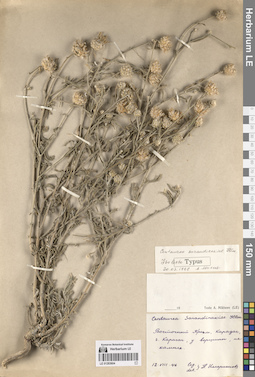
LE 01283604
Additional identifications: Centaurea sarandinakiae N.B. Illar. det. Illarionova, Nadezhda Borisovna at 12.08.1946; Isolectotype of Centaurea sarandinakiae N.B. Illar. det. Mikheev, Anatolij Dmitrievich at 30.03.1998 Collectors: Illarionova, Nadezhda Borisovna Collection date: 12.08.1946. Administrative regions: RU - Republic of Crimea. Subregion: городской округ Феодосия. Топоним: Карадаг (Кара-Даг). Place of collection: гора Карагач, у вершины.Groups of specimens: Образцы сектора Кавказа; Соглашение Минобрнауки №075-15-2021-1056Original label text:
Восточный Крым, Карадаг, гора Карагач, у вершины, на камнях.
Landscape in location of collection: теплоумеренный пояс, граница предгорных степей и смешанных (субсредиземноморских) лесовHabitat / plant community in location of collecting: на камняхRecord creation: 2024-05-30, PhotoScan D2.Citation: Specimen LE 01283604 // Virtual herbarium of Komarov Botanical Institute RAS — http://re.herbariumle.ru/01283604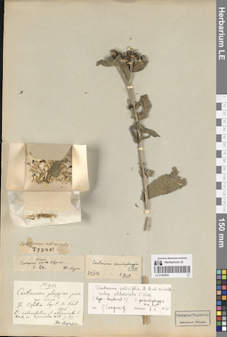
LE 01283603
Additional identifications: Centaurea phrygia L. ⟮prelim. ID⟯ det. Dr. Kosch at 1836; Type of Centaurea abbreviata (K. Koch) Hand.-Mazz. det. Busch; Centaurea pseudophrygia C.A. Mey. det. Busch, Nikolai Adolfovich (Nikolaj Adolfowitsch) at 29.04.1936; Centaurea salicifolia M. Bieb. subsp. abbreviata C. Koch det. Wogeniz, G. at 08.07.1975 Collectors: Dr. Kosch Field collecting number: 938. Collection date: 1836. Administrative regions: RU - North Ossetia. Groups of specimens: Образцы сектора Кавказа; Соглашение Минобрнауки №075-15-2021-1056; Herbarium of Meyer; Herbarium Academiae Scientiarum Petropol.Original label text:
In Ossetia
Record creation: 2024-05-30, PhotoScan D2.Citation: Specimen LE 01283603 // Virtual herbarium of Komarov Botanical Institute RAS — http://re.herbariumle.ru/01283603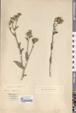
LE 01283602
Additional identifications: Centaurea salicifolia M. Bieb. det. Busch; Centaurea salicifolia M. Bieb. det. Czerepanov, Sergei Kirillovich at 11.1959 Collectors: Busch Groups of specimens: Образцы сектора Кавказа; Соглашение Минобрнауки №075-15-2021-1056Original label text:
Caucasus
Comment: Specimen authenticum
Record creation: 2024-05-30, PhotoScan D2.Citation: Specimen LE 01283602 // Virtual herbarium of Komarov Botanical Institute RAS — http://re.herbariumle.ru/01283602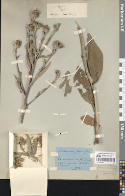
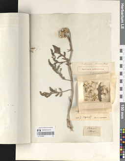
LE 01283601
Additional identifications: Centaurea salicifolia M. Bieb. det. Busch at 1802; Type of Centaurea salicifolia M. Bieb. det. Czerepanov, Sergei Kirillovich at 11.1959 Collectors: Busch Collection date: 1802. Administrative regions: RU - North Ossetia. Subregion: городской округ Владикавказ. Топоним: город Владикавказ. Place of collection: вокруг города Владикавкказ, на реке Терек.Groups of specimens: Образцы сектора Кавказа; Соглашение Минобрнауки №075-15-2021-1056; Herbarium Academiae Scientiarum Petropol.Original label text:
Ex campis ad fl. Terek, circa arcim Wladicaucas.
Landscape in location of collection: теплоумеренный пояс, граница предгорных степей и смешанных (влажных) лесовHabitat / plant community in location of collecting: на лугу у рекиRecord creation: 2024-05-30, PhotoScan D2.Citation: Specimen LE 01283601 // Virtual herbarium of Komarov Botanical Institute RAS — http://re.herbariumle.ru/01283601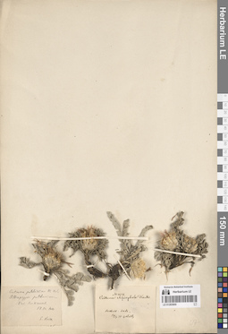
LE 01283600
Additional identifications: Centaurea rhizocephala Trautv. det. Trautvetter, Ernst Rudolf von at 29.07.1871; Centaurea pulcherrima Willd. det. Brin Collectors: illegible Field collecting number: 454. Collection date: 29.07.1871. Groups of specimens: Образцы сектора Кавказа; Соглашение Минобрнауки №075-15-2021-1056Original label text:
Aschich-dade
Record creation: 2024-05-30, PhotoScan D2.. Processing status: data is not fully enteredCitation: Specimen LE 01283600 // Virtual herbarium of Komarov Botanical Institute RAS — http://re.herbariumle.ru/01283600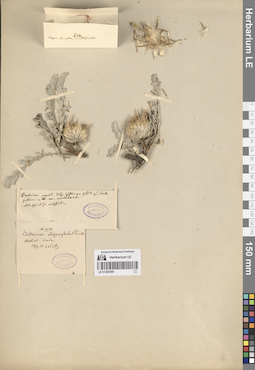
LE 01283599
Centaurea rhizocephala Trautv. det. Trautvetter, Ernst Rudolf von at 29.07.1871
Collectors: Radde, Gustav Ferdinand Richard Johannes von Field collecting number: 454. Collection date: 29.07.1871. Groups of specimens: Образцы сектора Кавказа; Соглашение Минобрнауки №075-15-2021-1056; Herbarium TrautvetterOriginal label text:Aschich-dade
Record creation: 2024-05-30, PhotoScan D2.. Processing status: data is not fully enteredCitation: Specimen LE 01283599 // Virtual herbarium of Komarov Botanical Institute RAS — http://re.herbariumle.ru/01283599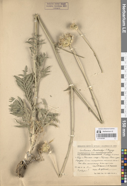
LE 01283598
Centaurea razdorskyi Karjag. ⟨Topotypus!⟩ det. Tzvelev, Nikolai Nikolaievich at 12.06.1957
Collectors: Tzvelev, Nikolai Nikolaievich; Czerepanov, Sergei Kirillovich Field collecting number: 1. Collection date: 12.06.1957. Administrative regions: AZ - Absheron Rayon. Subregion: Пирекешкюльский административно-территориальный округ. Place of collection: между селом Пирекешкюль и урочищем Агриджа, гора Шах-Даг.Groups of specimens: Образцы сектора Кавказа; Соглашение Минобрнауки №075-15-2021-1056; Herbarium Instituti Botanici Acad. Sc. URSSOriginal label text:Азербайджанская ССР. К северу от шоссе город Баку - город Шемаха между селом Перрикеш-Кюль и урочищем Агриджа. Слегка солонцеватый каменистый склон горы Шах-Даг южной экспозиции ...
Landscape in location of collection: теплоумеренные предгорные степиHabitat / plant community in location of collecting: слегка солонцеватый каменистый склон южной экспозицииRecord creation: 2024-05-30, PhotoScan D2.. Processing status: label contains unreadable dataCitation: Specimen LE 01283598 // Virtual herbarium of Komarov Botanical Institute RAS — http://re.herbariumle.ru/01283598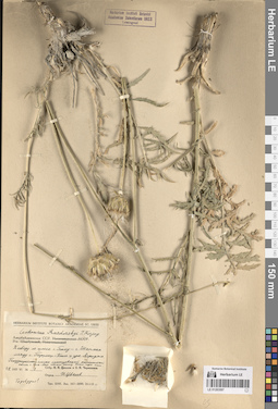
LE 01283597
Centaurea razdorskyi Karjag. ⟨Topotypus!⟩ det. Tzvelev, Nikolai Nikolaievich at 12.06.1957
Collectors: Tzvelev, Nikolai Nikolaievich; Czerepanov, Sergei Kirillovich Field collecting number: 1. Collection date: 12.06.1957. Administrative regions: AZ - Absheron Rayon. Subregion: Пирекешкюльский административно-территориальный округ. Place of collection: между селом Пирекешкюль и урочищем Агриджа, гора Шах-Даг.Groups of specimens: Образцы сектора Кавказа; Соглашение Минобрнауки №075-15-2021-1056; Herbarium Instituti Botanici Acad. Sc. URSSOriginal label text:Азербайджанская ССР. К северу от шоссе город Баку - город Шемаха между селом Перрикеш-Кюль и урочищем Агриджа. Полузакрепленный слегка солонцеватый каменистый склон горы Шах-Даг южной экспозиции ...
Landscape in location of collection: теплоумеренные предгорные степиHabitat / plant community in location of collecting: слегка солонцеватый каменистый склон южной экспозицииRecord creation: 2024-05-30, PhotoScan D2.. Processing status: label contains unreadable dataCitation: Specimen LE 01283597 // Virtual herbarium of Komarov Botanical Institute RAS — http://re.herbariumle.ru/01283597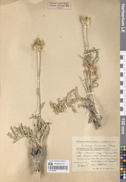
LE 01283596
Centaurea razdorskyi Karjag. ⟨Topotypus!⟩ det. Tzvelev, Nikolai Nikolaievich at 12.06.1957
Collectors: Tzvelev, Nikolai Nikolaievich; Czerepanov, Sergei Kirillovich Field collecting number: 1. Collection date: 12.06.1957. Administrative regions: AZ - Absheron Rayon. Subregion: Пирекешкюльский административно-территориальный округ. Place of collection: между селом Пирекешкюль и урочищем Агриджа, гора Шах-Даг.Groups of specimens: Образцы сектора Кавказа; Соглашение Минобрнауки №075-15-2021-1056; Herbarium Instituti Botanici Acad. Sc. URSSOriginal label text:Азербайджанская ССР. К северу от шоссе город Баку - город Шемаха между селом Перрикеш-Кюль и урочищем Агриджа. Слегка солонцеватый каменистый склон горы Шах-Даг южной экспозиции ...
Landscape in location of collection: теплоумеренные предгорные степиHabitat / plant community in location of collecting: слегка солонцеватый каменистый склон южной экспозицииRecord creation: 2024-05-30, PhotoScan D2.. Processing status: label contains unreadable dataCitation: Specimen LE 01283596 // Virtual herbarium of Komarov Botanical Institute RAS — http://re.herbariumle.ru/01283596
LE 01283794
Groups of specimens: Образцы сектора Восточной Европы; Соглашение Минобрнауки №075-15-2021-1056Record creation: 2024-05-31, Artyom Borodushkin, PhotoScan D2.Citation: Specimen LE 01283794 // Virtual herbarium of Komarov Botanical Institute RAS — http://re.herbariumle.ru/01283794
LE 01283793
Groups of specimens: Образцы сектора Восточной Европы; Соглашение Минобрнауки №075-15-2021-1056Record creation: 2024-05-31, Artyom Borodushkin, PhotoScan D2.Citation: Specimen LE 01283793 // Virtual herbarium of Komarov Botanical Institute RAS — http://re.herbariumle.ru/01283793
LE 01283792
Groups of specimens: Образцы сектора Восточной Европы; Соглашение Минобрнауки №075-15-2021-1056Record creation: 2024-05-31, Artyom Borodushkin, PhotoScan D2.Citation: Specimen LE 01283792 // Virtual herbarium of Komarov Botanical Institute RAS — http://re.herbariumle.ru/01283792
LE 01283791
Groups of specimens: Образцы сектора Восточной Европы; Соглашение Минобрнауки №075-15-2021-1056Record creation: 2024-05-31, Artyom Borodushkin, PhotoScan D2.Citation: Specimen LE 01283791 // Virtual herbarium of Komarov Botanical Institute RAS — http://re.herbariumle.ru/01283791
LE 01283790
Groups of specimens: Образцы сектора Восточной Европы; Соглашение Минобрнауки №075-15-2021-1056Record creation: 2024-05-31, Artyom Borodushkin, PhotoScan D2.Citation: Specimen LE 01283790 // Virtual herbarium of Komarov Botanical Institute RAS — http://re.herbariumle.ru/01283790
LE 01283789
Groups of specimens: Образцы сектора Восточной Европы; Соглашение Минобрнауки №075-15-2021-1056Record creation: 2024-05-31, Artyom Borodushkin, PhotoScan D2.Citation: Specimen LE 01283789 // Virtual herbarium of Komarov Botanical Institute RAS — http://re.herbariumle.ru/01283789
LE 01283788
Groups of specimens: Образцы сектора Восточной Европы; Соглашение Минобрнауки №075-15-2021-1056Record creation: 2024-05-31, Artyom Borodushkin, PhotoScan D2.Citation: Specimen LE 01283788 // Virtual herbarium of Komarov Botanical Institute RAS — http://re.herbariumle.ru/01283788
LE 01283787
Groups of specimens: Образцы сектора Восточной Европы; Соглашение Минобрнауки №075-15-2021-1056Record creation: 2024-05-31, Artyom Borodushkin, PhotoScan D2.Citation: Specimen LE 01283787 // Virtual herbarium of Komarov Botanical Institute RAS — http://re.herbariumle.ru/01283787
LE 01283786
Groups of specimens: Образцы сектора Восточной Европы; Соглашение Минобрнауки №075-15-2021-1056Record creation: 2024-05-31, Artyom Borodushkin, PhotoScan D2.Citation: Specimen LE 01283786 // Virtual herbarium of Komarov Botanical Institute RAS — http://re.herbariumle.ru/01283786
LE 01283785
Groups of specimens: Образцы сектора Восточной Европы; Соглашение Минобрнауки №075-15-2021-1056Record creation: 2024-05-31, Artyom Borodushkin, PhotoScan D2.Citation: Specimen LE 01283785 // Virtual herbarium of Komarov Botanical Institute RAS — http://re.herbariumle.ru/01283785
LE 01283784
Groups of specimens: Образцы сектора Восточной Европы; Соглашение Минобрнауки №075-15-2021-1056Record creation: 2024-05-31, Artyom Borodushkin, PhotoScan D2.Citation: Specimen LE 01283784 // Virtual herbarium of Komarov Botanical Institute RAS — http://re.herbariumle.ru/01283784
LE 01283783
Groups of specimens: Образцы сектора Восточной Европы; Соглашение Минобрнауки №075-15-2021-1056Record creation: 2024-05-31, Artyom Borodushkin, PhotoScan D2.Citation: Specimen LE 01283783 // Virtual herbarium of Komarov Botanical Institute RAS — http://re.herbariumle.ru/01283783