View
Add
Copy
Edit
Delete
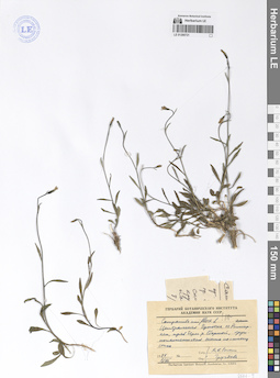
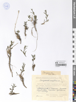
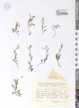
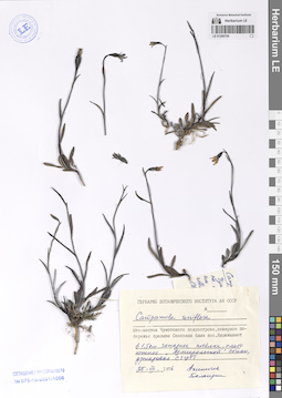
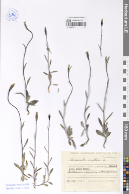
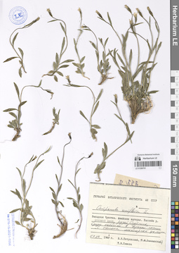
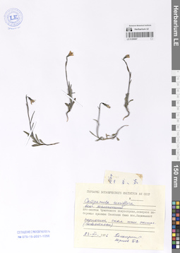
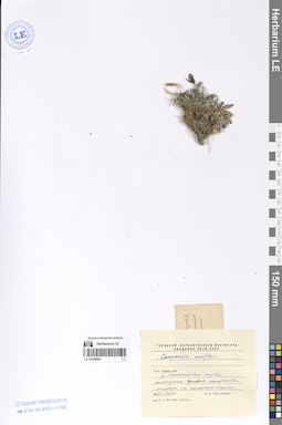
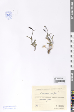
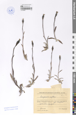
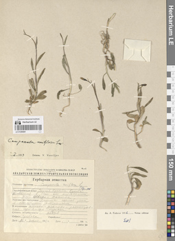
LE 01290721
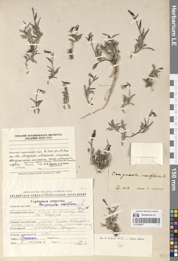
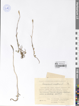
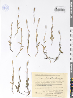
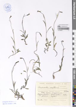
Campanula uniflora L.
Collectors: Sytin, Andrej Kirillovich; Gruzdeva, Nina Vassiljevna Collection date: 08.07.1974. Administrative regions: RU - Chukotskiy Avtonomnyy Okrug. Groups of specimens: Образцы сектора Сибири и Дальнего Востока РоссииOriginal label text:Центральная Чукотка, озеро Рымыркен, правый берег реки Сборной, крупнокаменистая осыпь по склону сопки.
Comment: 8.VII.1974
А. К. Сытин, Груздева
Central Chukotka, Lake Rymyrken, right bank of the Sbornaya River, large-stone scree on the slope of a hill.
Record creation: 2024-08-04, Daria Yudova, PhotoScan D2.Citation: Specimen LE 01290721 // Virtual herbarium of Komarov Botanical Institute RAS — http://re.herbariumle.ru/012907218.07.1974
Coll. A. K. Sytin, N. V. Gruzdeva
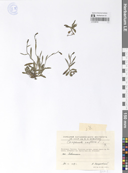
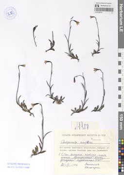
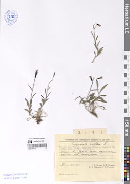
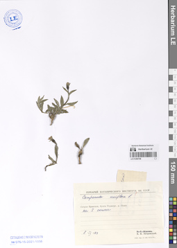
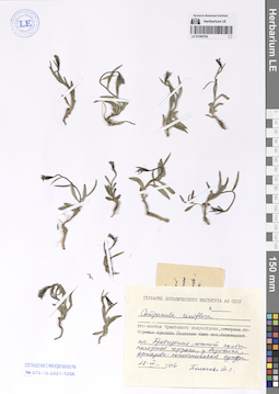
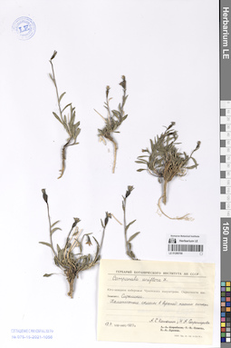
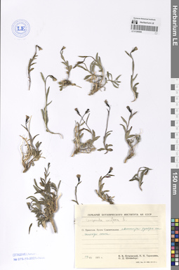
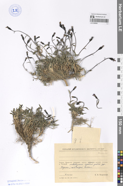
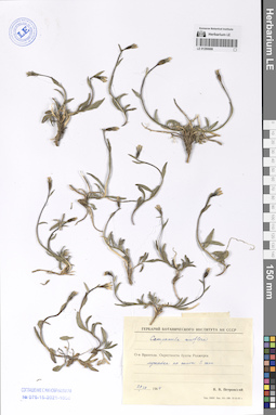
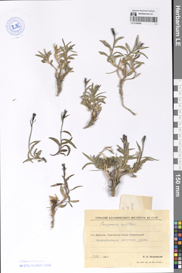
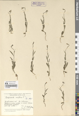
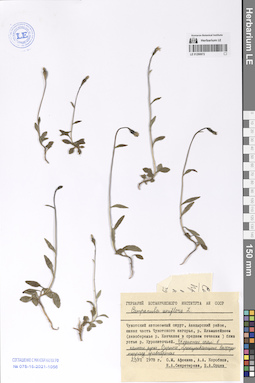
LE 01290720
Campanula uniflora L.
Collectors: Petrovsky, Vladislav Vladimirovich Collection date: 30.06.1967. Administrative regions: RU - Chukotskiy Avtonomnyy Okrug. Groups of specimens: Образцы сектора Сибири и Дальнего Востока РоссииOriginal label text:Восточная Чукотка. Чукотское нагорье, южные отроги хребта Искатень, побережье залива Креста близ поселка Эгвекинот. Поселок Эгвекинот.
Coordinates (geographic position): 66° 19′ 26.06″ N, 179° 7′ 39.09″ WComment: 30.VI.1967
В. Петровский
Eastern Chukotka. Chukotka Highlands, southern spurs of the Iskaten' Ridge, coast of Kresta Bay near the village of Egvekinot.
Record creation: 2024-08-04, Daria Yudova, PhotoScan D2.Citation: Specimen LE 01290720 // Virtual herbarium of Komarov Botanical Institute RAS — http://re.herbariumle.ru/0129072030.06.1967
Coll. V. Petrovsky
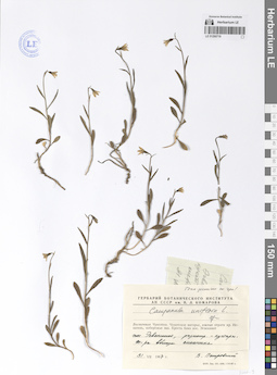
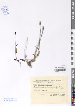
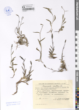
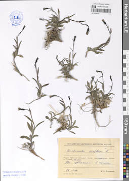
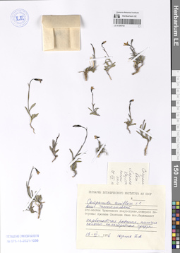
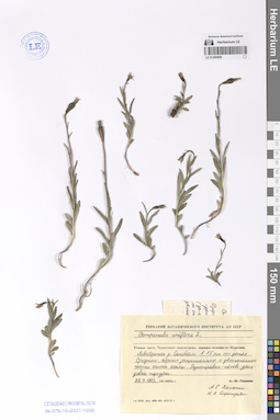
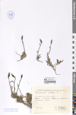
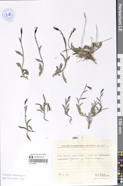
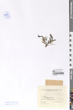
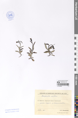
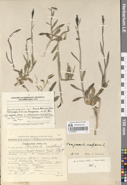
LE 01290719
Campanula uniflora L.
Collectors: Petrovsky, Vladislav Vladimirovich Collection date: 31.07.1967. Administrative regions: RU - Chukotskiy Avtonomnyy Okrug. Groups of specimens: Образцы сектора Сибири и Дальнего Востока РоссииOriginal label text:Восточная Чукотка. Чукотское нагорье, южные отроги хребта Искатень, побережье залива Креста близ поселка Эгвекинот. Поселок Эгвекинот, разнотравно-кустарниковая тундра вблизи снежника.
Coordinates (geographic position): 66° 18′ 46.92″ N, 179° 8′ 33.35″ WComment: 31.VII.1967
В. Петровский
Eastern Chukotka. Chukotka Highlands, southern spurs of the Iskateni Ridge, coast of Kresta Bay near the village of Egvekinot. The village of Egvekinot, forb-shrub tundra near a snowfield.
Record creation: 2024-08-04, Daria Yudova, PhotoScan D2.Citation: Specimen LE 01290719 // Virtual herbarium of Komarov Botanical Institute RAS — http://re.herbariumle.ru/0129071931.07.1967
Coll. V. Petrovsky
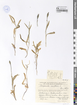
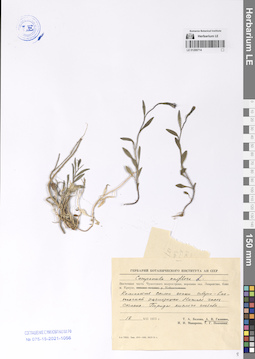
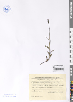
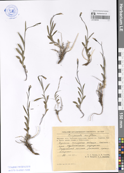
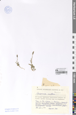
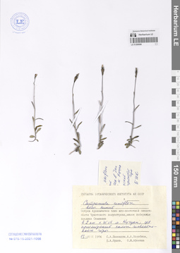
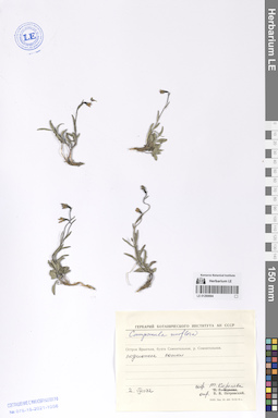
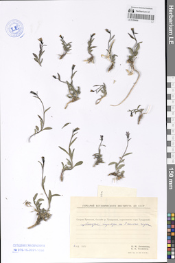
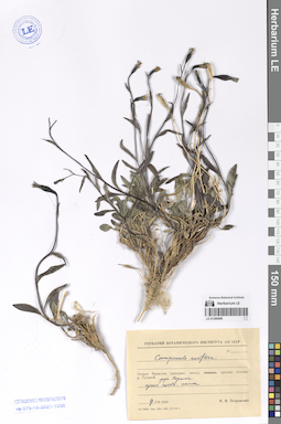
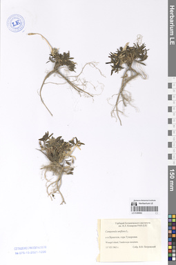
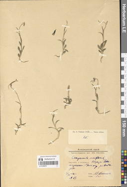
LE 01290718
Campanula uniflora L.
Collectors: Korobkov, Aleksandr Aleksandrovich Collection date: 27.08.1967. Administrative regions: RU - Chukotskiy Avtonomnyy Okrug. Groups of specimens: Образцы сектора Сибири и Дальнего Востока РоссииOriginal label text:Восточная Чукотка. Чукотское нагорье, южные отроги хребта Искатень, побережье залива Креста близ поселка Эгвекинот. Правобережье реки Нырвакинотвеем [= Эрвыкыннотвеем], 13 км трассы, верхняя половина восточного склона в расселине высоких андезитовых скал.
Coordinates (geographic position): 66° 27′ 0.03″ N, 179° 11′ 56.04″ WComment: 27.VIII.1967
А. А. Коробков
Eastern Chukotka. Chukotka Highlands, southern spurs of the Iskaten' Ridge, coast of Kresta Bay near the village of Egvekinot. Right bank of the Nyrvakinotveem [= Ervykynnotveem] River, 13 km of the highway, upper half of the eastern slope in a crevice of high andesite cliffs.
27.08.1967
Coll. A. A. Korobkov
LE 01290717
Campanula uniflora L.
Collectors: Balandin, Sergey Aleksandrovich; Gruzdeva, Nina Vassiljevna; Sytin, Andrej Kirillovich; Jurtzev, Boris Alexandrovich Collection date: 07.07.1974. Administrative regions: RU - Chukotskiy Avtonomnyy Okrug. Groups of specimens: Образцы сектора Сибири и Дальнего Востока РоссииOriginal label text:Чукотский национальный округ. Центральная часть Чукотского нагорья, левобережье реки Пегтымель в среднем течении близ озера Рымаркен. Левобережье реки Сборной, дриадово-кассиоповая горная тундра по СЗ склону.
Comment: 7.VII.1974
С. А. Баландин, Н. В. Груздева, А. К. Сытин, Б. А. Юрцев
Chukotka National Okrug. Central part of the Chukotka Highlands, left bank of the Tsegtymel River in the middle reaches near Lake Rymarken. Left bank of the Sbornaya River, dryad-cassiope mountain tundra along the northwest slope.
Record creation: 2024-08-04, Daria Yudova, PhotoScan D2.Citation: Specimen LE 01290717 // Virtual herbarium of Komarov Botanical Institute RAS — http://re.herbariumle.ru/012907177.07.1974
Coll. S. A. Balandin, N. V. Gruzdeva, A. K. Sytin, B. A. Jurtzev
LE 01290716
Campanula uniflora L.
Collection date: 25.07.1976. Administrative regions: RU - Chukotskiy Avtonomnyy Okrug. Groups of specimens: Образцы сектора Сибири и Дальнего Востока РоссииOriginal label text:Юго-восток Чукотского полуострова, северное побережье пролива Сенявина близ поселка Янракыннот. В 1,5 км западнее поселка, плато южнее "Адмиральской" сопки, дриадовая СГУТТ.
Coordinates (geographic position): 64° 55′ 7.83″ N, 172° 38′ 33.13″ WComment: 25.VII.1976
Акиничев, Баландин
South-east of the Chukotka Peninsula, northern coast of the Senyavin Strait near the village of Yanrakynnot. 1.5 km west of the village, plateau south of the "Admiral'skaya" hill.
Record creation: 2024-08-04, Daria Yudova, PhotoScan D2.Citation: Specimen LE 01290716 // Virtual herbarium of Komarov Botanical Institute RAS — http://re.herbariumle.ru/0129071625.07.1976
Coll. Akinichev, Balandin
LE 01290715
Campanula uniflora L.
Collectors: Galanin, Alexander Vladimirovich Collection date: 02.08.1973. Administrative regions: RU - Chukotskiy Avtonomnyy Okrug. Groups of specimens: Образцы сектора Сибири и Дальнего Востока РоссииOriginal label text:Восточная часть Чукотского полуострова, вершина залива Лаврентия, близ мыса Краузе. Злаково-ивнячковая сухая луговина на пологом склоне, сложенном породами кислого состава.
Coordinates (geographic position): 65° 49′ 26.27″ N, 171° 29′ 27.25″ WComment: 2.VIII.1973
А. В. Галанин
Eastern part of the Chukotka Peninsula, the head of the Saint Lawrence Bay, near Cape Krause. Dry grass-willow meadow on a gentle slope composed of acidic rocks.
Record creation: 2024-08-04, Daria Yudova, PhotoScan D2.Citation: Specimen LE 01290715 // Virtual herbarium of Komarov Botanical Institute RAS — http://re.herbariumle.ru/012907152.08.1973
Coll. A. V. Galanin
LE 01290714
Campanula uniflora L.
Collectors: Galanin, Alexander Vladimirovich Collection date: 12.07.1973. Administrative regions: RU - Chukotskiy Avtonomnyy Okrug. Groups of specimens: Образцы сектора Сибири и Дальнего Востока РоссииOriginal label text:Восточная часть Чукотского полуострова, вершина залива Лаврентия, близ мыса Краузе. Каменистый склон сопки северо-восточной экспозиции. Нижняя часть склона. Породы кислого состава.
Coordinates (geographic position): 65° 49′ 9.02″ N, 171° 29′ 8.69″ WComment: 12.VII.1973
А. В. Галанин
Eastern part of the Chukotka Peninsula, the top of the Saint Lawrence Bay, near Cape Krause. Rocky slope of a hill with northeastern exposure. Lower part of the slope. Rocks of acidic composition.
12.07.1973
Coll. A. V. Galanin
LE 01290713
Campanula uniflora L.
Collectors: Kozhevnikov, Yury Pavlovich; Nechaev, Anatoly Andreevich; Jurtzev, Boris Alexandrovich Collection date: 10.07.1970. Administrative regions: RU - Chukotskiy Avtonomnyy Okrug. Groups of specimens: Образцы сектора Сибири и Дальнего Востока РоссииOriginal label text:Восточная часть Чукотского полуострова, озеро Коолень, 5 км к ЗЮЗ от северной оконечности, сухая луговинная тундра у подножья S склона сопки.
Coordinates (geographic position): 65° 58′ 32.78″ N, 171° 6′ 42.5″ WComment: 10.VII.1970
Ю. П. Кожевников, А. А. Нечаев, Б. А. Юрцев
Eastern part of the Chukotka Peninsula, Lake Koolen, 5 km WSW from the northern end, dry meadow tundra at the foot of the S slope of the hill.
10.07.1970
Coll. Yu. P. Kozhevnikov, A. A. Nechaev, B. A.Jurtzev
LE 01290712
Campanula uniflora L.
Collectors: Galanin, Alexander Vladimirovich Collection date: 25.07.1973. Administrative regions: RU - Chukotskiy Avtonomnyy Okrug. Groups of specimens: Образцы сектора Сибири и Дальнего Востока РоссииOriginal label text:Восточная часть Чукотского полуострова, вершина залива Лаврентия, близ мыса Краузе. Скалы в верхней части карбонатного склона северной экспозиции.
Coordinates (geographic position): 65° 48′ 59.77″ N, 171° 27′ 24.36″ WComment: 25.VII.1973
А. В. Галанин
Eastern part of the Chukotka Peninsula, the head of the Gulf of Lavrentiya, near Cape Krause. Rocks in the upper part of the carbonate slope of the northern exposure.
25.VII.1973
Coll. A. V. Galanin
LE 01290711
Campanula uniflora L.
Collectors: Galanin, Alexander Vladimirovich Collection date: 28.07.1973. Administrative regions: RU - Chukotskiy Avtonomnyy Okrug. Groups of specimens: Образцы сектора Сибири и Дальнего Востока РоссииOriginal label text:Восточная часть Чукотского полуострова, вершина залива Лаврентия, близ мыса Краузе. Сухие щебнистые карбонатные тундры у подножия скалистых останцов на берегу залива, южная экспозиция.
Coordinates (geographic position): 65° 48′ 25.91″ N, 171° 25′ 43.84″ WComment: 28.VII.1973
А. В. Галанин
Eastern part of the Chukotka Peninsula, the head of the Gulf of Lavrentiya, near Cape Krause. Dry, gravelly carbonate tundra at the foot of rocky outcrops on the shore of the gulf, southern exposure.
Record creation: 2024-08-04, Daria Yudova, PhotoScan D2.Citation: Specimen LE 01290711 // Virtual herbarium of Komarov Botanical Institute RAS — http://re.herbariumle.ru/0129071128.07.1973
Coll. A. V. Galanin
LE 01290710
Campanula uniflora L.
Collectors: Galanin, Alexander Vladimirovich; Polozova, Tamara Georgievna Collection date: 02.08.1973. Administrative regions: RU - Chukotskiy Avtonomnyy Okrug. Groups of specimens: Образцы сектора Сибири и Дальнего Востока РоссииOriginal label text:Восточная часть Чукотского полуострова, вершина залива Лаврентия, близ мыса Краузе, река Шумная. Нижняя часть горного склона долины левого притока, Ю-В экспозиция. Щебнистая редкотравная тундра.
Coordinates (geographic position): 65° 46′ 49.53″ N, 171° 28′ 22.07″ WComment: 2.VIII.1973
А. В. Галанин, Т. Г. Полозова
Eastern part of the Chukotka Peninsula, the head of the Lavrentiya Gulf, near the Krause Cape, the Shumnaya River. Lower part of the mountain slope of the left tributary valley, south-east exposure. Stony sparse-grass tundra.
Record creation: 2024-08-04, Daria Yudova, PhotoScan D2.Citation: Specimen LE 01290710 // Virtual herbarium of Komarov Botanical Institute RAS — http://re.herbariumle.ru/012907102.08.1973
Coll. A. V. Galanin, T. G. Polozova
LE 01290709
Campanula uniflora L.
Collection date: 25.07.1976. Administrative regions: RU - Chukotskiy Avtonomnyy Okrug - Providenskiy Rayon. Groups of specimens: Образцы сектора Сибири и Дальнего Востока РоссииOriginal label text:Юго-восток Чукотского полуострова, северное побережье пролива Сенявина близ поселка Янракыннот. В 1,5 км западнее поселка, плато южнее "Адмиральской" сопки, дриадовая СГУТТ.
Coordinates (geographic position): 64° 55′ 7.83″ N, 172° 38′ 33.13″ WComment: 25.VII.1976
Акиничев, Баландин
South-east of the Chukotka Peninsula, northern coast of the Senyavin Strait near the village of Yanrakynnot. 1.5 km west of the village, plateau south of the "Admiral'skaya" hill.
Record creation: 2024-08-04, Daria Yudova, PhotoScan D2.Citation: Specimen LE 01290709 // Virtual herbarium of Komarov Botanical Institute RAS — http://re.herbariumle.ru/0129070925.07.1976
Coll. Akinichev, Balandin
LE 01290708
Campanula uniflora L.
Collectors: Petrovsky, Vladislav Vladimirovich Collection date: 08.07.1979. Administrative regions: RU - Chukotskiy Avtonomnyy Okrug. Groups of specimens: Образцы сектора Сибири и Дальнего Востока РоссииOriginal label text:Остров Врангеля, бухта Роджерс, река Наша. На S склоне.
Coordinates (geographic position): 71° 0′ 37.22″ N, 178° 24′ 13.83″ WComment: 8.VII.1979
В. В. Петровский
Wrangel Island, Rogers Bay, Nasha River. On the S slope.
Record creation: 2024-08-04, Daria Yudova, PhotoScan D2.Citation: Specimen LE 01290708 // Virtual herbarium of Komarov Botanical Institute RAS — http://re.herbariumle.ru/012907088.07.1979
Coll. V. V. Petrovsky
LE 01290707
Campanula uniflora L.
Collectors: Petrovsky, Vladislav Vladimirovich Collection date: 14.07.1979. Administrative regions: RU - Chukotskiy Avtonomnyy Okrug. Groups of specimens: Образцы сектора Сибири и Дальнего Востока РоссииOriginal label text:Остров Врангеля (западная часть), среднее течение реки Гусиной, балок. На щебнистом S склоне.
Coordinates (geographic position): 71° 6′ 20.67″ N, 179° 29′ 39.21″ EComment: 14.VII.1979
В. В. Петровский
Wrangel Island (western part), middle reaches of the Gusinaya River. On a gravelly S slope.
Record creation: 2024-08-04, Daria Yudova, PhotoScan D2.Citation: Specimen LE 01290707 // Virtual herbarium of Komarov Botanical Institute RAS — http://re.herbariumle.ru/0129070714.07.1979
Coll. V. V. Petrovsky
LE 01290706
Campanula uniflora L.
Collectors: Polozova, Tamara Georgievna Collection date: 28.07.1973. Administrative regions: RU - Chukotskiy Avtonomnyy Okrug. Groups of specimens: Образцы сектора Сибири и Дальнего Востока РоссииOriginal label text:Восточная часть Чукотского полуострова, вершина зал. Лаврентия, близ мыса Краузе, нижнее течение реки Койматкеваам. Вершина скалистого останца, сложенного карбонатными породами. Торфянистый холмик зоогенного происхождения.
Coordinates (geographic position): 65° 50′ 31.5″ N, 171° 27′ 48.9″ WComment: 28.VII.1973
Т. Г. Полозова
Eastern part of the Chukotka Peninsula, the top of the Gulf of Lawrence, near the Krause Cape, the lower reaches of the Koimatkevaam River. The top of a rocky outlier composed of carbonate rocks.
Record creation: 2024-08-04, Daria Yudova, PhotoScan D2.Citation: Specimen LE 01290706 // Virtual herbarium of Komarov Botanical Institute RAS — http://re.herbariumle.ru/0129070628.07.1973
Coll. T. G. Polozova
LE 01290705
Campanula uniflora L.
Collectors: Petrovsky, Vladislav Vladimirovich; Plieva, T.V. Collection date: 03.08.1981. Administrative regions: RU - Chukotskiy Avtonomnyy Okrug. Groups of specimens: Образцы сектора Сибири и Дальнего Востока РоссииOriginal label text:Западная Чукотка. Бассейн реки Большой Анюй, ручей Лисий. Галечник притока каскадный.
Coordinates (geographic position): 67° 3′ 5.48″ N, 162° 19′ 29.35″ EComment: 03.08.1981
В. В. Петровский, Т. В. Плиева
Western Chukotka. Basin of the Bolshoi Anyui River, Lisiy stream.
3.08.1981
Coll. V. V. Petrovsky, T. V. Plieva
LE 01290704
Campanula uniflora L.
Collectors: Polozova, Tamara Georgievna Collection date: 12.07.1976. Administrative regions: RU - Chukotskiy Avtonomnyy Okrug. Groups of specimens: Образцы сектора Сибири и Дальнего Востока РоссииOriginal label text:Юго-восток Чукотского полуострова, поселок Провидения, южный склон нагорной террасы, у водотока, дриадово-копеечниковая тундра.
Coordinates (geographic position): 64° 23′ 39.04″ N, 173° 10′ 35.03″ WComment: 12.VII.1976
Пологова Т. Г.
South-east of the Chukotka Peninsula, Provideniya village, southern slope of the mountain terrace.
Record creation: 2024-08-04, Daria Yudova, PhotoScan D2.Citation: Specimen LE 01290704 // Virtual herbarium of Komarov Botanical Institute RAS — http://re.herbariumle.ru/0129070412.07.1976
Coll. T. G. Polozova
LE 01290703
Campanula uniflora L.
Collectors: Jurtzev, Boris Alexandrovich Collection date: 18.07.1976. Administrative regions: RU - Chukotskiy Avtonomnyy Okrug - Providenskiy Rayon. Groups of specimens: Образцы сектора Сибири и Дальнего Востока РоссииOriginal label text:Юго-восток Чукотского полуострова, северное побережье пролива Сенявина близ поселка Янракыннот. Карбонатная равнина, пологие склоны, кальцеритная тундра.
Coordinates (geographic position): 64° 55′ 14.75″ N, 172° 32′ 24.72″ WComment: 18.VII.1976
Юрцев Б. А.
South-east of the Chukotka Peninsula, northern coast of the Senyavin Strait near the village of Yanrakynnot. Carbonate plain, gentle slopes, calcerite tundra.
Record creation: 2024-08-04, Daria Yudova, PhotoScan D2.Citation: Specimen LE 01290703 // Virtual herbarium of Komarov Botanical Institute RAS — http://re.herbariumle.ru/0129070318.07.1976
Coll. B. A. Jurtzev
LE 01290702
Campanula uniflora L.
Collectors: Jurtzev, Boris Alexandrovich Collection date: 28.07.1976. Administrative regions: RU - Chukotskiy Avtonomnyy Okrug - Providenskiy Rayon. Groups of specimens: Образцы сектора Сибири и Дальнего Востока РоссииOriginal label text:Юго-восток Чукотского полуострова, северное побережье пролива Сенявина близ поселка Янракыннот. 4 км к СВ, отроги горы Рээччен, некарбонатный делговит (средний эффузив), с-в склон, скопления мелкозема среди камменых колец.
Coordinates (geographic position): 64° 55′ 44.62″ N, 172° 24′ 43.71″ WComment: 28.VII.1976
Юрцев Б. А.
South-east of the Chukotka Peninsula, northern coast of the Senyavin Strait near the village of Yanrakynnot. 4 km to the NE, spurs of Mount Reechchen.
28.07.1976
Coll. B. A. Jurtzev
LE 01290701
Campanula uniflora L.
Collectors: Petrovsky, Vladislav Vladimirovich; Plieva, T.V. Collection date: 07.07.1981. Administrative regions: RU - Chukotskiy Avtonomnyy Okrug. Groups of specimens: Образцы сектора Сибири и Дальнего Востока РоссииOriginal label text:Западная Чукотка. Анюйское нагорье. Бассейн реки Большой Анюй, ручей Спутник, среди камней в верхнейчасти S склона межгорной долины.
Comment: 7.07.1981
В. В. Петровский, Т. В. Плиева
Western Chukotka. Anyui Highland. Bolshoy Anyui River basin, Sputnik Creek, among rocks in the upper part of the S slope of the intermountain valley.
Record creation: 2024-08-04, Daria Yudova, PhotoScan D2.Citation: Specimen LE 01290701 // Virtual herbarium of Komarov Botanical Institute RAS — http://re.herbariumle.ru/012907017.07.1981
Coll. V. V. Petrovsky, T. V. Plieva
LE 01290700
Campanula uniflora L.
Collectors: Katenin, Adrian Evgenevich; Sekretareva, Nadezhda Alexandrovna Collection date: 12.07.1983. Administrative regions: RU - Chukotskiy Avtonomnyy Okrug. Groups of specimens: Образцы сектора Сибири и Дальнего Востока РоссииOriginal label text:Юго-западное побережье Чукотского полуострова. Окрестности поселка Сиреники. Каменистые склоны в верхней части сопки.
Coordinates (geographic position): 64° 25′ 18.94″ N, 173° 57′ 53.06″ WComment: 12.07.1983
А. Е. Катенин, Н. А. Секретарева
Southwest coast of the Chukotka Peninsula. The vicinity of the village of Sireniki. Rocky slopes in the upper part of the hill.
Record creation: 2024-08-04, Daria Yudova, PhotoScan D2.Citation: Specimen LE 01290700 // Virtual herbarium of Komarov Botanical Institute RAS — http://re.herbariumle.ru/0129070012.07.1983
Coll. A. E. Katenin, N. A. Sekretareva
LE 01290699
Campanula uniflora L.
Collectors: Sekretareva, Nadezhda Alexandrovna; Katenin, Adrian Evgenevich Collection date: 22.07.1983. Administrative regions: RU - Chukotskiy Avtonomnyy Okrug. Groups of specimens: Образцы сектора Сибири и Дальнего Востока РоссииOriginal label text:Южная часть Чукотского полуострова. Левобережье реки Синевеем в 15 км от устья Среднии, хорошо защищенные и увлажненные части склона сопки. Разнотравно-ивнево-дриадовые тундры.
Coordinates (geographic position): 64° 37′ 34.51″ N, 173° 42′ 30.28″ WComment: 22.7.1983
А. Е. Катенин, Н. А. Секретарева
Southern part of the Chukotka Peninsula. Left bank of the Sineveyem River 15 km from the mouth of the Srednyaya, well-protected and moistened parts of the slope of the hill. Forb-willow-dryad tundra.
Record creation: 2024-08-04, Daria Yudova, PhotoScan D2.Citation: Specimen LE 01290699 // Virtual herbarium of Komarov Botanical Institute RAS — http://re.herbariumle.ru/0129069922.07.1983
Coll. A. E. Katenin, N. A. Sekretareva
LE 01290698
Campanula uniflora L.
Collectors: Balandin, Sergey Aleksandrovich; Korobkov, Aleksandr Aleksandrovich; Jurtzev, Boris Alexandrovich; Afonina, Olga Mikhailovna Collection date: 13.08.1976. Administrative regions: RU - Chukotskiy Avtonomnyy Okrug. Groups of specimens: Образцы сектора Сибири и Дальнего Востока РоссииOriginal label text:(венчик синий)
Coordinates (geographic position): 64° 49′ 41.66″ N, 172° 21′ 50.45″ WComment: Остров Аракамчечен близ юго-восточной оконечности Чукотского полуострова, южное побережье пролива Сенявина. В 2 км к W от м. Кугуан [Кугуван], северный приморский склон известняковой горы.
13.VIII.1976
С. А. Баландин, А. А. Коробков, Б. А. Юрцев, О. М. Афонина
(blue corolla)
Record creation: 2024-08-04, Daria Yudova, PhotoScan D2.Citation: Specimen LE 01290698 // Virtual herbarium of Komarov Botanical Institute RAS — http://re.herbariumle.ru/01290698Arakamchechen Island near the southeastern tip of the Chukotka Peninsula, southern coast of the Senyavin Strait. 2 km to the W of Cape Kuguan [Kuguvan], northern seaside slope of a limestone mountain.
13.08.1976
Coll. S. A. Balandin, A. A. Korobkov, B. A. Jurtzev, O. M. Afonina
LE 01290697
Campanula uniflora L.
Collectors: Balandin, Sergey Aleksandrovich; Jurtzev, Boris Alexandrovich Collection date: 23.07.1976. Administrative regions: RU - Chukotskiy Avtonomnyy Okrug. Groups of specimens: Образцы сектора Сибири и Дальнего Востока РоссииOriginal label text:(венчик темно-синий)
Coordinates (geographic position): 64° 55′ 38.54″ N, 172° 35′ 35.03″ WComment: Юго-восток Чукотского полуострова, северное побережье пролива Сенявина близ поселка Янракыннот. Подножье скал южной экспозиции (известняки).
23.VII.1976
Баландин С., Юрцев Б. А.
(dark blue corolla)
Record creation: 2024-08-04, Daria Yudova, PhotoScan D2.Citation: Specimen LE 01290697 // Virtual herbarium of Komarov Botanical Institute RAS — http://re.herbariumle.ru/01290697Southeast of the Chukotka Peninsula, northern coast of the Senyavin Strait near the village of Yanrakynnot. Foothills of the southern exposure cliffs (limestones).
23.07.1976
Coll. S. Balandin, B. A. Jurtzev
LE 01290696
Campanula uniflora L.
Collectors: Petrovsky, Vladislav Vladimirovich; Taraskina, N.; Steinberg, O. D. Collection date: 14.07.1971. Administrative regions: RU - Chukotskiy Avtonomnyy Okrug. Groups of specimens: Образцы сектора Сибири и Дальнего Востока РоссииOriginal label text:Остров Врангеля. Бухта Сомнительная. Пятнистая тундра на [...] сопки.
Coordinates (geographic position): 70° 54′ 27.67″ N, 179° 27′ 17.39″ WComment: 14.VII.1971
В. В. Петровский, Н. Н. Тараскина, О. Д. Штейнберг
Wrangel Island. Somnitel'naya Bay. Spotted tundra on [...] hills.
Record creation: 2024-08-04, Daria Yudova, PhotoScan D2.Citation: Specimen LE 01290696 // Virtual herbarium of Komarov Botanical Institute RAS — http://re.herbariumle.ru/0129069614.07.1971
Coll. V. V. Petrovsky, N. N. Taraskina, O. D. Steinberg
LE 01290695
Campanula uniflora L. det. Petrovsky, Vladislav Vladimirovich
Collectors: Koroleva (Zaslavskaya), Tatiana Collection date: 11.08.1972. Administrative regions: RU - Chukotskiy Avtonomnyy Okrug. Groups of specimens: Образцы сектора Сибири и Дальнего Востока РоссииOriginal label text:Остров Врангеля, бухта Роджерс. Сухая полынная тундра у подножия S склона сопки.
Coordinates (geographic position): 70° 59′ 30.09″ N, 178° 23′ 48.25″ WComment: 11.VIII.1972
Т. Королева
Wrangel Island, Rogers Bay. Dry wormwood tundra at the foot of the S slope of the hill.
Record creation: 2024-08-04, Daria Yudova, PhotoScan D2.Citation: Specimen LE 01290695 // Virtual herbarium of Komarov Botanical Institute RAS — http://re.herbariumle.ru/0129069511.08.1972
Coll. Т. Koroleva
LE 01290694
Campanula uniflora L. det. Petrovsky, Vladislav Vladimirovich
Collectors: Koroleva (Zaslavskaya), Tatiana Collection date: 02.08.1972. Administrative regions: RU - Chukotskiy Avtonomnyy Okrug. Groups of specimens: Образцы сектора Сибири и Дальнего Востока РоссииOriginal label text:Остров Врангеля, бухта Сомнительная, река Сомнительная. Подножье сопки.
Coordinates (geographic position): 70° 57′ 9.34″ N, 179° 35′ 39.17″ WComment: 2.VIII.1972
Т. Королева
Wrangel Island, Somnitelnaya Bay, Somnitelnaya River. Foot of the hill.
Record creation: 2024-08-04, Daria Yudova, PhotoScan D2.Citation: Specimen LE 01290694 // Virtual herbarium of Komarov Botanical Institute RAS — http://re.herbariumle.ru/012906942.08.1972
Coll. T. Koroleva
LE 01290693
Campanula uniflora L.
Collectors: Petrovsky, Vladislav Vladimirovich Collection date: 26.07.1964. Administrative regions: RU - Chukotskiy Avtonomnyy Okrug. Groups of specimens: Образцы сектора Сибири и Дальнего Востока РоссииOriginal label text:Остров Врангеля. Река Мамонтовая - низовья. Разнотравно-дриадово-лишайниковая тундра на пойменной террасе.
Coordinates (geographic position): 70° 54′ 16.98″ N, 179° 33′ 15.05″ EComment: 1964 - 26.VII
В. В. Петровский
Wrangel Island. Mamontovaya River - lower reaches. Forb-dryad-lichen tundra on a floodplain terrace.
Record creation: 2024-08-04, Daria Yudova, PhotoScan D2.Citation: Specimen LE 01290693 // Virtual herbarium of Komarov Botanical Institute RAS — http://re.herbariumle.ru/0129069326.07.1964
Coll. V. V. Petrovsky
LE 01290692
Campanula uniflora L.
Collectors: Petrovsky, Vladislav Vladimirovich Collection date: 01.07.1969. Groups of specimens: Образцы сектора Сибири и Дальнего Востока РоссииOriginal label text:Остров Врангеля (западная часть), среднее течение реки Гусиной. Левобережье против устья ручья Корали; щебнистый склон.
Comment: 1.VII.1969
В. В. Петровский
Wrangel Island (western part), middle reaches of the Gusinaya river. The Corali stream. Gravelly slope.
Record creation: 2024-08-04, Daria Yudova, PhotoScan D2.Citation: Specimen LE 01290692 // Virtual herbarium of Komarov Botanical Institute RAS — http://re.herbariumle.ru/012906921.07.1969
Coll. V. V. Petrovsky
LE 01290691
Campanula uniflora L.
Collectors: Zhukova, P. G.; Petrovsky, Vladislav Vladimirovich Collection date: 02.07.1970. Administrative regions: RU - Chukotskiy Avtonomnyy Okrug. Groups of specimens: Образцы сектора Сибири и Дальнего Востока РоссииOriginal label text:Остров Врангеля, среднее течение реки Гусиной, руч. Корали - у бывшего лагеря.
Comment: 2.VII.1970
П. Г. Жукова
В. В. Петровский
Wrangel Island, middle reaches of the Gusinaya river, the Corali stream.
Record creation: 2024-08-04, Daria Yudova, PhotoScan D2.Citation: Specimen LE 01290691 // Virtual herbarium of Komarov Botanical Institute RAS — http://re.herbariumle.ru/012906912.07.1970
Coll. P. G. Zhukova, V. V. Petrovsky
LE 01290690
Campanula uniflora L.
Collectors: Litvinova, N. M.; Tikhmenev, E. A. Collection date: 04.07.1970. Administrative regions: RU - Chukotskiy Avtonomnyy Okrug. Groups of specimens: Образцы сектора Сибири и Дальнего Востока РоссииOriginal label text:Остров Врангеля, бассейн реки Тундровой, окрестности горы Тундровой. Щебнистая тундра на S склоне горы.
Coordinates (geographic position): 71° 14′ 18.49″ N, 179° 57′ 15.75″ EComment: 4.VII.1970
Н. М. Литвинова
Е. А. Тихменев
Wrangel Island, the Tundrovaya River basin, surroundings of the Tundrovaya Mount. Rubble tundra on the S slope of the mountain.
4.07.1970Coll. N. M. Litvinova, E. A. Tikhmenev.
LE 01290689
Campanula uniflora L.
Collectors: Schamurin (Shamurin) V.Ph.; L. I. Shepelenko Collection date: 22.07.1966. Administrative regions: RU - Chukotskiy Avtonomnyy Okrug. Groups of specimens: Образцы сектора Сибири и Дальнего Востока РоссииOriginal label text:Чукотский национальный округ. Остров Врангеля, район бухты Сомнительной.
Coordinates (geographic position): 70° 56′ 54.68″ N, 179° 39′ 24.82″ WComment: Галечник реки.
22.VII.1966
В. Ф. Шамурин, Л. И. Шепеленко
Chukotka National District. Wrangel Island, vicinity of the Somnitelnaya Bay.
22.07.1966Coll. V. Ph. Schamurin, L. I. Shamurin
LE 01290688
Campanula uniflora L.
Collectors: Petrovsky, Vladislav Vladimirovich Collection date: 29.07.1964. Administrative regions: RU - Chukotskiy Avtonomnyy Okrug. Groups of specimens: Образцы сектора Сибири и Дальнего Востока РоссииOriginal label text:Остров Врангеля. Окрестности бухты Роджерса. Лужайка на склоне S экспозиции.
Coordinates (geographic position): 70° 59′ 4″ N, 178° 23′ 58″ EComment: 29.VII.1964
В. В. Петровский
Wrangel Island. Vicinity of the Rogers Bay. Lawn on a slope of the southern exposure.
29.07.1964Coll. V. V. Petrovsky
LE 01290687
Campanula uniflora L.
Collectors: Petrovsky, Vladislav Vladimirovich Collection date: 14.07.1964. Administrative regions: RU - Chukotskiy Avtonomnyy Okrug. Groups of specimens: Образцы сектора Сибири и Дальнего Востока РоссииOriginal label text:Остров Врангеля. Г. Тундровая. Щебнистая вершина.
Coordinates (geographic position): 71° 14′ 18.49″ N, 179° 57′ 15.75″ EComment: 1964.14.07
В. В. Петровский
Wrangel island, Tundrovaya mountain.
Record creation: 2024-08-04, Daria Yudova, PhotoScan D2.Citation: Specimen LE 01290687 // Virtual herbarium of Komarov Botanical Institute RAS — http://re.herbariumle.ru/01290687А rubble peak.
14.07.1964
Coll. V. V. Petrovsky
LE 01290686
Campanula uniflora L.
Collectors: Petrovsky, Vladislav Vladimirovich Collection date: 17.07.1969. Administrative regions: RU - Chukotskiy Avtonomnyy Okrug. Groups of specimens: Образцы сектора Сибири и Дальнего Востока РоссииOriginal label text:Остров Врангеля (западная часть), среднее течение р. Гусиной. Руч. Корали. Сухой щебнистый склон.
Coordinates (geographic position): 71° 6′ 48.01″ N, 179° 25′ 30.37″ EComment: Wrangel Island (western part), middle reaches of the Gusinaya river. The Corali stream. Dry gravelly slope.
Record creation: 2024-08-04, Daria Yudova, PhotoScan D2.Citation: Specimen LE 01290686 // Virtual herbarium of Komarov Botanical Institute RAS — http://re.herbariumle.ru/0129068617.07.1969
Coll. V. V. Petrovsky
LE 01290685
Campanula uniflora L.
Collectors: Petrovsky, Vladislav Vladimirovich Collection date: 07.08.1969. Administrative regions: RU - Chukotskiy Avtonomnyy Okrug. Groups of specimens: Образцы сектора Сибири и Дальнего Востока РоссииOriginal label text:Остров Врангеля (центральная часть), окрестности горы Советской, бассейн р. Хищников - верховья. Ручей Лагерный. Щебнистая тундра.
Coordinates (geographic position): 71° 4′ 13.79″ N, 179° 21′ 6.47″ WComment: 7.VIII.1969
В. В. Петровский
Wrangel Island (central part), surroundings of Sovetskaya Mountain, the Chischnaya river basin - upper reaches. The Lagerny stream. Rubble tundra.
Record creation: 2024-08-04, Daria Yudova, PhotoScan D2.Citation: Specimen LE 01290685 // Virtual herbarium of Komarov Botanical Institute RAS — http://re.herbariumle.ru/012906857.08.1969
Coll. V. V. Petrovsky
LE 01290684
Campanula uniflora L.
Collectors: Petrovsky, Vladislav Vladimirovich Collection date: 03.08.1964. Administrative regions: RU - Chukotskiy Avtonomnyy Okrug. Groups of specimens: Образцы сектора Сибири и Дальнего Востока РоссииOriginal label text:Остров Врангеля. Окрестности бухты Сомнительной. Зарастающий галечник ручья.
Coordinates (geographic position): 70° 56′ 54.68″ N, 179° 39′ 24.82″ WComment: 3.VIII.1964
В. В. Петровский
Wrangel Island. The vicinity of Somnitelnaya Bay. Overgrown pebbles of a stream.
Record creation: 2024-08-04, Daria Yudova, PhotoScan D2.Citation: Specimen LE 01290684 // Virtual herbarium of Komarov Botanical Institute RAS — http://re.herbariumle.ru/012906843.08.1964
V. V. Petrovsky
LE 01290683
Campanula uniflora L.
Collectors: Petrovsky, Vladislav Vladimirovich Collection date: 04.08.1964. Administrative regions: RU - Chukotskiy Avtonomnyy Okrug. Groups of specimens: Образцы сектора Сибири и Дальнего Востока РоссииOriginal label text:Остров Врангеля. Окрестности бухты Сомнительной. Речная терраса у метеоплощадки.
Coordinates (geographic position): 70° 53′ 29.45″ N, 179° 28′ 36.19″ WComment: 4.VIII.1964
В. В. Петровский
Wrangel Island. The environs of Somnitelnaya Bay. River terrace near the meteorological site.
Record creation: 2024-08-04, Daria Yudova, PhotoScan D2.Citation: Specimen LE 01290683 // Virtual herbarium of Komarov Botanical Institute RAS — http://re.herbariumle.ru/012906834.08.1964
Coll. V. V. Petrovsky
LE 01290682
Campanula uniflora L.
Collectors: Petrovsky, Vladislav Vladimirovich Collection date: 15.07.1965. Administrative regions: RU - Chukotskiy Avtonomnyy Okrug. Groups of specimens: Образцы сектора Сибири и Дальнего Востока РоссииOriginal label text:остров Врангеля, гора Тундровая.
Coordinates (geographic position): 71° 14′ 18.49″ N, 179° 57′ 15.75″ EComment: Wrangel island, Tundrovaya mountain.
15.VII.1965
Coбр. В. В. Петровский
Wrangel island, Tundrovaya mountain.
15.07.1965
Coll. V. V. Petrovsky
LE 01290681
Campanula uniflora L.
Collection date: 30.07.1951. Administrative regions: RU - Chukotskiy Avtonomnyy Okrug. Groups of specimens: Образцы сектора Сибири и Дальнего Востока РоссииOriginal label text:Залив Креста. Бухта Оловянная в 1 км от аэродрома на северо-восток. Долина горной реки с песчаными отмелями. Злаково-разнотравная луговинная тундра. Редко.
Coordinates (geographic position): 66° 12′ 36.31″ N, 179° 0′ 32.39″ WComment: 30 июля 1951 г.
Грибова
Kresta Bay. Olovyannaya Bay 1 km from the airfield to the northeast. Mountain river valley with sandbanks. Grass-forb meadow tundra. Rare.
Record creation: 2024-08-04, Daria Yudova, PhotoScan D2.Citation: Specimen LE 01290681 // Virtual herbarium of Komarov Botanical Institute RAS — http://re.herbariumle.ru/0129068130.07.1951
Coll. Gribova
LE 01290680
Campanula uniflora L.
Collectors: Derviz-Sokolova, Tatiana Georgievna Field collecting number: 802. Collection date: 17.07.1964. Administrative regions: RU - Chukotskiy Avtonomnyy Okrug - Iul'tinskiy Rayon. Groups of specimens: Образцы сектора Сибири и Дальнего Востока РоссииOriginal label text:Магаданская обл. Пос. Эгвекинот. Кустарничковая тундра на конусе выноса. Каменистый субстрат.
Coordinates (geographic position): 66° 19′ 41.82″ N, 179° 7′ 51.56″ WComment: № 802
17.VII.1964
Т. Дервиз-Соколова
Magadan Region. The Egvekinot village. Shrub tundra on an alluvial fan. Rocky substrate.
Record creation: 2024-08-04, Daria Yudova, PhotoScan D2.Citation: Specimen LE 01290680 // Virtual herbarium of Komarov Botanical Institute RAS — http://re.herbariumle.ru/01290680№ 802
17.07.1964
Coll. T. Derviz-Sokolova
LE 01290679
Campanula uniflora L.
Collectors: Reutt, A.T. Field collecting number: 189. Collection date: 30.07.1956. Administrative regions: RU - Chukotskiy Avtonomnyy Okrug. Groups of specimens: Образцы сектора Сибири и Дальнего Востока РоссииOriginal label text:Чукотский национальный округ. Залив Креста, бухта Эвекинот [Эгвекинот] в 1 км от аэродрома на СВ. Долина горной реки с песчаными отмелями. Злаково-разнотравная луговинная тундра. Редко.
Coordinates (geographic position): 66° 22′ 7″ N, 179° 5′ 38.4″ WComment: № 189
30.VII.1956
А. Т. Реутт.
Chukotka National District. Kresta Gulf, Evekinot Bay [Egvekinot] 1 km from the airfield on the NE. Valley of a mountain river with sandbanks.
30.07.1956Coll. A.T. Reutt
LE 01290678
Campanula uniflora L.
Collectors: Vassiljev, Viktor Nikolayevich Field collecting number: 63. Collection date: 31.07.1932. Administrative regions: RU - Chukotskiy Avtonomnyy Okrug. Expedition: Чукотско-Анадырская экспедиция НКЗ (1932 -1933)Groups of specimens: Образцы сектора Сибири и Дальнего Востока РоссииOriginal label text:Бассейн р. Анадыря. Окрестности Ново-Мариинска. [Утес ...] р. Анадырем.
Coordinates (geographic position): 64° 44′ 15.4″ N, 177° 27′ 46.16″ EComment: № 63.
31/VII.1932
В. Васильев
Basin of the Anadyr River. Vicinity of the city of Novo-Mariinsk [= Anadyr].
№ 63
31.07.1932
Coll. V. N. Vassiljev
LE 01290677
Campanula uniflora L.
Collectors: Berezina Field collecting number: 269. Collection date: 08.07.1951. Administrative regions: RU - Chukotskiy Avtonomnyy Okrug. Groups of specimens: Образцы сектора Сибири и Дальнего Востока РоссииOriginal label text:Чукотский национальный округ, в 1 км на Ю-Зап. от пос. Анадырь. Морская терраса Анадырского лимана. Склон небольшого холма вост. экпоз. Щебнистая тундра. Часто.
Coordinates (geographic position): 64° 43′ 25.87″ N, 177° 31′ 44.98″ EComment: 1951 8.VII.
Березина
Chukotka National District, 1 km to the South-West from the Anadyr village. Marine terrace of the Anadyr Estuary. East facing slope of a small hill. Rubble tundra. Often.
Record creation: 2024-08-04, Daria Yudova, PhotoScan D2.Citation: Specimen LE 01290677 // Virtual herbarium of Komarov Botanical Institute RAS — http://re.herbariumle.ru/012906778.07.1951
Coll. Berezina
LE 01290676
Campanula uniflora L.
Collectors: Gruzdeva, Nina Vassiljevna; Sytin, Andrej Kirillovich Collection date: 14.08.1974. Administrative regions: RU - Chukotskiy Avtonomnyy Okrug. Groups of specimens: Образцы сектора Сибири и Дальнего Востока РоссииOriginal label text:Чукотский нац. округ, северное побережье Анадырского лимана близ пос. Угольный Комбинат, Шахтерский-3. Южные отроги Золотого хребта. Восточный склон сопки, обращенный к лиману, щебень.
Coordinates (geographic position): 64° 44′ 42.82″ N, 177° 39′ 23.16″ EComment: 14.VIII.1974
Н. В. Груздева, А. К. Сытин
Chukotka national okrug, northern coast of the Anadyr estuary near the village Coal Combine, Shakhtersky-3. Southern spurs of the Golden Ridge. The eastern slope of the hill, facing the estuary. Crushed stone.
18.08.1974Coll. N. V. Gruzdeva, A. K. Sytin
LE 01290675
Campanula uniflora L.
Collectors: Gruzdeva, Nina Vassiljevna; Sytin, Andrej Kirillovich Collection date: 18.08.1974. Administrative regions: RU - Chukotskiy Avtonomnyy Okrug. Groups of specimens: Образцы сектора Сибири и Дальнего Востока РоссииOriginal label text:Чукотский нац. округ, северное побережье Анадырского лимана близ пос. Угольный Комбинат, Шахтерский-3. Южные отроги Золотого хребта. Нивальная тундра.
Coordinates (geographic position): 64° 44′ 42.82″ N, 177° 39′ 23.16″ EComment: 18.VIII.1974
Н. В. Груздева, А. К. Сытин
Chukotka national okrug, northern coast of the Anadyr estuary near the village Coal Combine, Shakhtersky-3. Southern spurs of the Golden Ridge. Nival tundra.
18.08.1974Coll. N. V. Gruzdeva, A. K. Sytin
LE 01290674
Campanula uniflora L.
Collectors: Petrovsky, Vladislav Vladimirovich; Plieva, T.V. Collection date: 03.07.1981. Administrative regions: RU - Chukotskiy Avtonomnyy Okrug. Groups of specimens: Образцы сектора Сибири и Дальнего Востока РоссииOriginal label text:Западная Чукотка. Бассейн реки Анадырь. Большой Анюй, ручей Спутник. Разнотравно-ерничковая тундра в долине ручья.
Comment: 3.07.1981
В. В. Петровский, Т. В. Плиева
Western Chukotka. Basin of the Anadyr River. Bolshoy Anyui, the Sputnik stream. Forb-bush tundra in a stream valley.
3.07.1981
Coll. V. V. Petrovsky, T. V. Plieva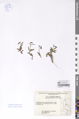
LE 01290673
Campanula uniflora L.
Collectors: Kharkevich, Sigismund Semenovich; Gorshkov, Michail Collection date: 29.07.1975. Administrative regions: RU - Kamtchatski Kray. Groups of specimens: Образцы сектора Сибири и Дальнего Востока РоссииOriginal label text:Kamchatskiy region, Olyoutorskiy district, island Vyerchoutourov, cobbled alpine tundra in S part of the island, rare.
Coordinates (geographic position): 59° 37′ 36.54″ N, 164° 39′ 42.06″ ERecord creation: 2024-08-04, Daria Yudova, PhotoScan D2.Citation: Specimen LE 01290673 // Virtual herbarium of Komarov Botanical Institute RAS — http://re.herbariumle.ru/01290673Leg. S. Kharkevich, M. Gorshkov
1975 VII 29
LE 01290672
Campanula uniflora L.
Collectors: Sekretareva, Nadezhda Alexandrovna; Jurtzev, Boris Alexandrovich Collection date: 29.07.1978. Administrative regions: RU - Chukotskiy Avtonomnyy Okrug. Groups of specimens: Образцы сектора Сибири и Дальнего Востока РоссииOriginal label text:Чукотский автономный округ, Анадырский район, южная часть Чукотского нагорья, р. Ильмынейвеем (левобережье р. Канчалан в среднем течении) близ устья р. Куропаточьей. Подножье скал в каньоне ручья "Озерного", пронизывающего высокую террасу правобережья.
Coordinates (geographic position): 66° 13′ 33.33″ N, 177° 19′ 10.49″ EComment: 29.VII.1978
Н. А. Секретарева, Б. А. Юрцев
Chukotka Autonomous Okrug, Anadyrsky district, southern part of the Chukotka Highlands, the Ilmyneyveem river (left bank of the Kanchalan river in the middle reaches) near the mouth of the Kuropatochiya river. The foot of the rocks in the canyon of the Ozerny stream.
29.07.1978Coll. N. A. Sekretareva, B. A. Jurtzev