View
Add
Copy
Edit
Delete
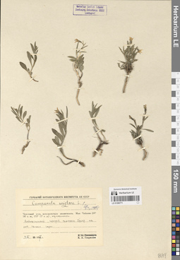
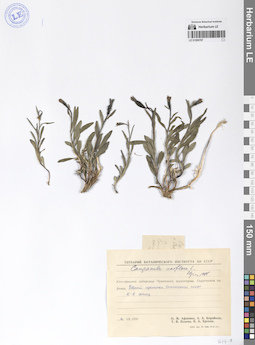
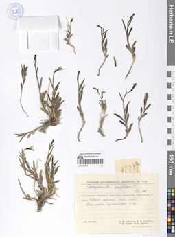
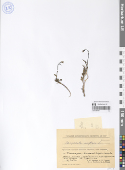
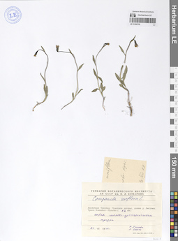
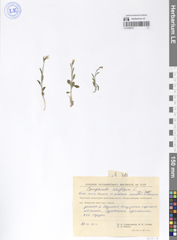
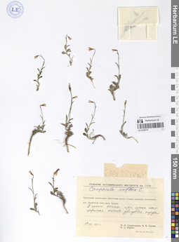
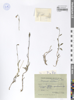
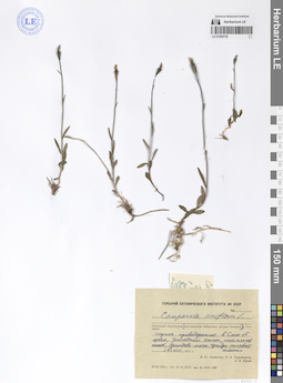
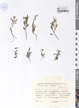
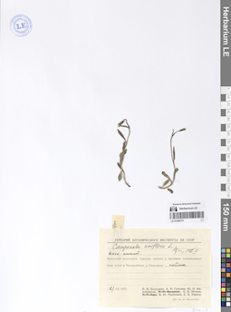
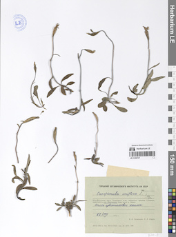
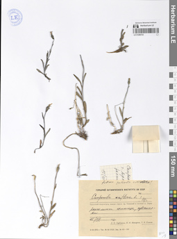
LE 01290771
Campanula uniflora L.
Collectors: Gavrilyuk, Victor Antonovich Collection date: 04.07.1957. Administrative regions: RU - Chukotskiy Avtonomnyy Okrug. Groups of specimens: Образцы сектора Сибири и Дальнего Востока РоссииOriginal label text:Чукотский полуостров, юго-восточная оконечность. Мыс Чаплина (64° 24' с. ш., 172° 12' з. д.), окрестности. Возвышенный, нагреваемый солнцем бугор на ЮВ склоне горы.
Coordinates (geographic position): 64° 24′ 30.99″ N, 172° 15′ 3.99″ WComment: 4.VII.1957
В. А. Гаврилюк
Chukotka Peninsula, southeastern end. Cape Chaplin (64° 24' N, 172° 12' W), environs. An elevated, sun-heated mound on the southeastern slope of the mountain.
Record creation: 2024-08-04, Daria Yudova, PhotoScan D2.Citation: Specimen LE 01290771 // Virtual herbarium of Komarov Botanical Institute RAS — http://re.herbariumle.ru/012907714.07.1957
Coll. V. A. Gavrilyuk
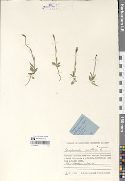
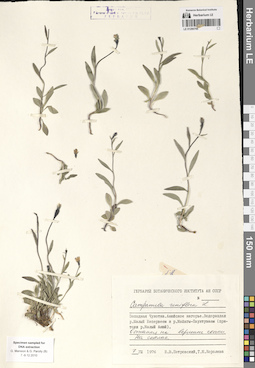
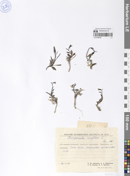
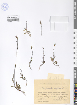
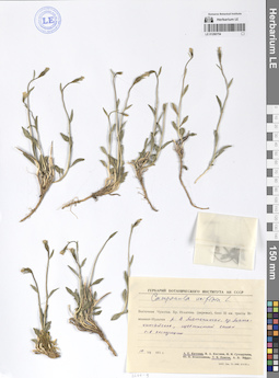
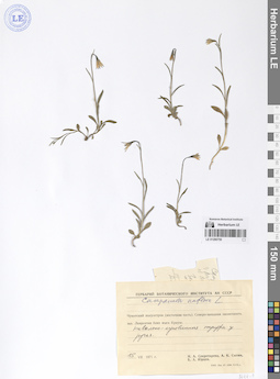
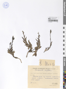
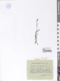
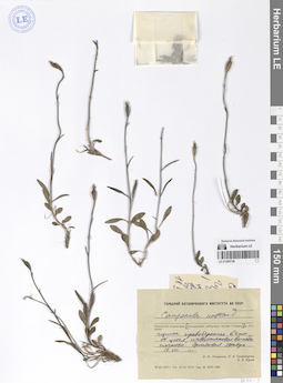
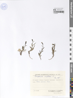
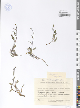
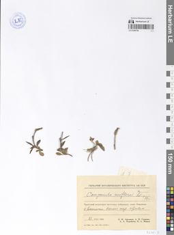
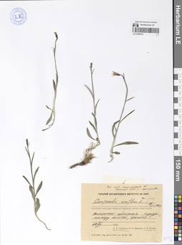
LE 01290770
Campanula uniflora L.
Collectors: Petrovsky, Vladislav Vladimirovich; Koroleva (Zaslavskaya), Tatiana Collection date: 04.08.1976. Administrative regions: RU - Chukotskiy Avtonomnyy Okrug. Groups of specimens: Образцы сектора Сибири и Дальнего Востока РоссииOriginal label text:Западная Чукотка. Анюйское нагорье. Водораздел реки Малый Кепервеем и реки Майнгы-Пауктуваам (притоки реки Малый Анюй). На останце - осыпь.
Coordinates (geographic position): 67° 55′ 17.98″ N, 166° 51′ 25.32″ EComment: 4.VIII.1976
В. В. Петровский, Т. М. Королева
Western Chukotka. Anyui Highland. Watershed of the Maly Keperveem River and the Maingy-Pauktuvaam River (tributaries of the Maly Anyui River).
Record creation: 2024-08-04, Daria Yudova, PhotoScan D2.Citation: Specimen LE 01290770 // Virtual herbarium of Komarov Botanical Institute RAS — http://re.herbariumle.ru/012907704.08.1976
Coll. V. V. Petrovsky, T. M. Koroleva
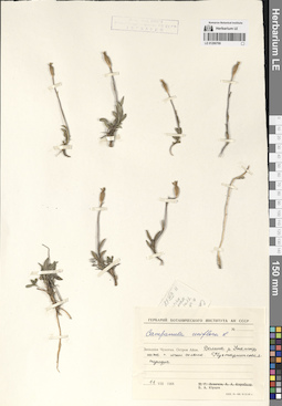
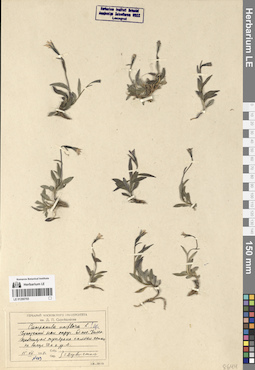
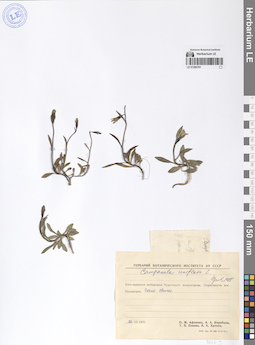
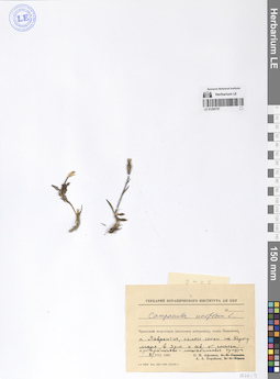
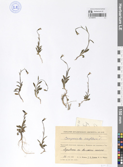
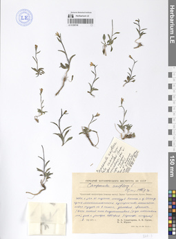
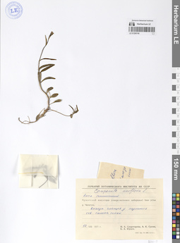
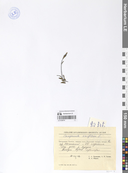
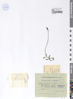
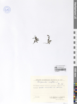
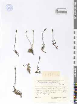
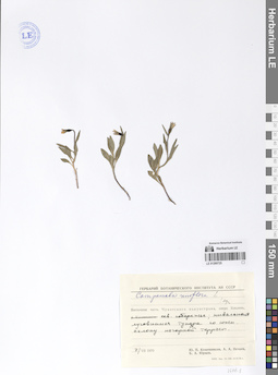
LE 01290769
Campanula uniflora L.
Collectors: Jurtzev, Boris Alexandrovich Collection date: 11.08.1968. Administrative regions: RU - Chukotskiy Avtonomnyy Okrug. Groups of specimens: Образцы сектора Сибири и Дальнего Востока РоссииOriginal label text:Западная Чукотка. Остров Айон. Долина реки Утатгыр ниже п. южного склона. Кустарничковая тундра.
Coordinates (geographic position): 69° 53′ 42.77″ N, 168° 0′ 1.45″ EComment: 11.VIII.1968
Б. А. Юрцев
Western Chukotka. Ayon Island. Valley of the Utatgyr River. Shrub tundra.
Record creation: 2024-08-04, Daria Yudova, PhotoScan D2.Citation: Specimen LE 01290769 // Virtual herbarium of Komarov Botanical Institute RAS — http://re.herbariumle.ru/0129076911.08.1968
Coll. B. A. Jurtzev
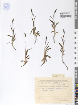
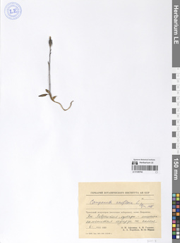
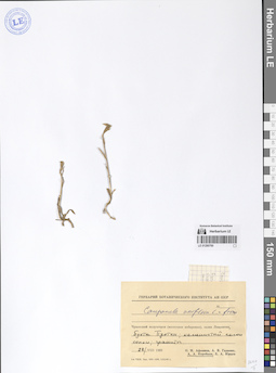
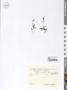
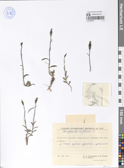
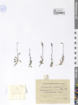
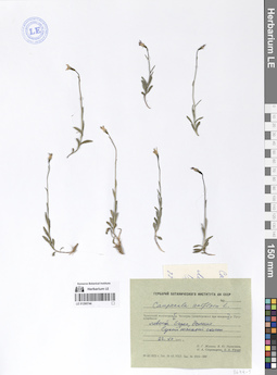
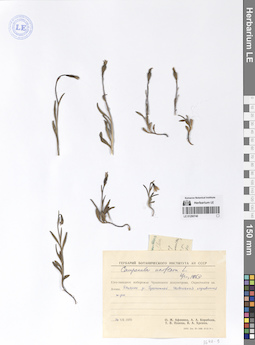
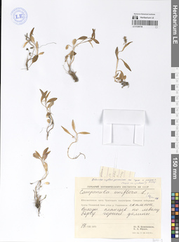
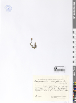
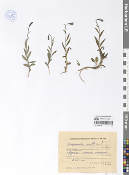
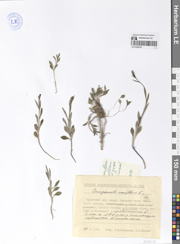
LE 01290768
Campanula uniflora L.
Collectors: Afonina, Olga Mikhailovna; Korobkov, Aleksandr Aleksandrovich; Plieva, T.V.; Khrenov, V. A. Collection date: 12.07.1970. Administrative regions: RU - Chukotskiy Avtonomnyy Okrug. Groups of specimens: Образцы сектора Сибири и Дальнего Востока РоссииOriginal label text:Юго-западное побережье Чукотского полуострова. Окрестности озера Аччен. Устье реки Гранитной, луговинная тундра у подножья склона.
Coordinates (geographic position): 64° 52′ 44.63″ N, 174° 56′ 6.79″ WComment: 12.VII.1970
О. М. Афонина, А. А. Коробков, Т.В. Плиева, В. А. Хренов
Southwest coast of the Chukotka Peninsula. The vicinity of Lake Achchen. The mouth of the Granitnaya River, meadow tundra at the foot of the slope.
Record creation: 2024-08-04, Daria Yudova, PhotoScan D2.Citation: Specimen LE 01290768 // Virtual herbarium of Komarov Botanical Institute RAS — http://re.herbariumle.ru/0129076812.07.1970
Coll. O. M. Afonina, A. A. Korobkov, T.V. Plieva, V. A. Khrenov
LE 01290767
Campanula uniflora L.
Collectors: Afonina, Olga Mikhailovna; Korobkov, Aleksandr Aleksandrovich; Plieva, T.V.; Khrenov, V. A. Collection date: 16.07.1970. Administrative regions: RU - Chukotskiy Avtonomnyy Okrug. Groups of specimens: Образцы сектора Сибири и Дальнего Востока РоссииOriginal label text:Юго-западное побережье Чукотского полуострова. Окрестности озера Аччен. Рыбный промысел. Остепненный склон Ю-В экспозиции.
Coordinates (geographic position): 64° 48′ 57.27″ N, 174° 45′ 0.15″ WComment: 16.VII.1970
О. М. Афонина, А. А. Коробков, Т. В. Плиева, В. А. Хренов
Southwest coast of the Chukotka Peninsula. Vicinity of Lake Achchen. Fishing industry. Steppe slope of south-east exposure.
Record creation: 2024-08-04, Daria Yudova, PhotoScan D2.Citation: Specimen LE 01290767 // Virtual herbarium of Komarov Botanical Institute RAS — http://re.herbariumle.ru/0129076716.07.1970
Coll. O. M. Afonina, A. A. Korobkov, T.V. Plieva, V. A. Khrenov
LE 01290766
Campanula uniflora L.
Collectors: Petrovsky, Vladislav Vladimirovich; Koroleva (Zaslavskaya), Tatiana Collection date: 07.08.1976. Administrative regions: RU - Chukotskiy Avtonomnyy Okrug. Groups of specimens: Образцы сектора Сибири и Дальнего Востока РоссииOriginal label text:Западная Чукотка. Анюйское нагорье. Водораздел реки Малый Кепервеем и реки Майнгы-Пауктуваам (притоки реки Малый Анюй). Останец на вершине сопки. На скалах.
Coordinates (geographic position): 67° 55′ 17.98″ N, 166° 51′ 25.32″ EComment: 7.VIII.1976
В. В. Петровский, Т. М. Королева
Western Chukotka. Anyui Highland. Watershed of the Maly Keperveem River and the Maingy-Pauktuvaam River (tributaries of the Maly Anyui River). On the rocks.
Record creation: 2024-08-04, Daria Yudova, PhotoScan D2.Citation: Specimen LE 01290766 // Virtual herbarium of Komarov Botanical Institute RAS — http://re.herbariumle.ru/012907667.08.1976
Coll. V. V. Petrovsky, T. M. Koroleva
LE 01290765
Campanula uniflora L.
Collectors: Derviz-Sokolova, Tatiana Georgievna Field collecting number: 403. Collection date: 15.07.1958. Administrative regions: RU - Chukotskiy Avtonomnyy Okrug. Groups of specimens: Образцы сектора Сибири и Дальнего Востока РоссииOriginal label text:Чукотский национальный округ. Близ поселка Уэлен. Щебнистая тундра на склоне сопки на высоте 50 м н. ур. м.
Coordinates (geographic position): 66° 9′ 20.61″ N, 169° 46′ 37.5″ WComment: № 403
15.VII.1958
Т. Дервиз-Соколова
Chukotka National District. Near the village of Uelen. Rubbly tundra on the slope of a hill at an altitude of 50 m above sea level.
Record creation: 2024-08-04, Daria Yudova, PhotoScan D2.Citation: Specimen LE 01290765 // Virtual herbarium of Komarov Botanical Institute RAS — http://re.herbariumle.ru/01290765№ 403
15.07.1958
Coll. T. Derviz-Sokolova
LE 01290764
Campanula uniflora L.
Collectors: Afonina, Olga Mikhailovna; Galanin, Alexander Vladimirovich; Korobkov, Aleksandr Aleksandrovich Collection date: 06.08.1969. Administrative regions: RU - Chukotskiy Avtonomnyy Okrug. Groups of specimens: Образцы сектора Сибири и Дальнего Востока РоссииOriginal label text:Чукотский полуостров (восточное побережье), залив Лаврентия. Поселок Лаврентия, кустарниково-лишайниковая каменистая тундра на склоне.
Coordinates (geographic position): 65° 35′ 57.14″ N, 171° 2′ 29.8″ WComment: 8.VIII.1969
О. М. Афонина, А. В. Галанин, А. А. Коробков
Chukotka Peninsula (east coast), Lavrentiya Bay. Lavrentiya village, shrub-lichen rocky tundra on the slope.
Record creation: 2024-08-04, Daria Yudova, PhotoScan D2.Citation: Specimen LE 01290764 // Virtual herbarium of Komarov Botanical Institute RAS — http://re.herbariumle.ru/012907646.08.1969
Coll. O. M. Afonina, A. V. Galanin, A. A. Korobkov
LE 01290763
Campanula uniflora L.
Collectors: Afonina, Olga Mikhailovna; Korobkov, Aleksandr Aleksandrovich; Plieva, T.V.; Khrenov, V. A. Collection date: 07.07.1970. Administrative regions: RU - Chukotskiy Avtonomnyy Okrug. Groups of specimens: Образцы сектора Сибири и Дальнего Востока РоссииOriginal label text:Юго-западное побережье Чукотского полуострова. Окрестности озера Аччен. Рыбный промысел. Склон сопки. Разнотравно-кустарничковая тундра.
Coordinates (geographic position): 64° 49′ 57.6″ N, 174° 42′ 48.34″ WComment: 7.VII.1970
О. М. Афонина, А. А. Коробков, Т. В. Плиева, В. А. Хренов
Southwest coast of the Chukotka Peninsula. Lake Achchen area. Fishing industry. Hill slope. Forb-shrub tundra.
Record creation: 2024-08-04, Daria Yudova, PhotoScan D2.Citation: Specimen LE 01290763 // Virtual herbarium of Komarov Botanical Institute RAS — http://re.herbariumle.ru/012907637.07.1970
Coll. O. M. Afonina, A. A. Korobkov, T. V. Plieva, V. A. Khrenov
LE 01290762
Campanula uniflora L.
Collectors: Afonina, Olga Mikhailovna; Korobkov, Aleksandr Aleksandrovich; Plieva, T.V.; Khrenov, V. A. Collection date: 28.06.1970. Administrative regions: RU - Chukotskiy Avtonomnyy Okrug. Groups of specimens: Образцы сектора Сибири и Дальнего Востока РоссииOriginal label text:Юго-западное побережье Чукотского полуострова. Окрестности поселка Нунлигран. Склон сопки, разнотравно-кустарниковая тундра.
Coordinates (geographic position): 64° 47′ 35.8″ N, 175° 20′ 10.32″ WComment: 29.VI.1970
О. М. Афонина, А. А. Коробков, Т. В. Плиева, В. А. Хренов
Southwest coast of the Chukotka Peninsula. The outskirts of the village of Nunligran. Hillside, grass-shrub tundra.
Record creation: 2024-08-04, Daria Yudova, PhotoScan D2.Citation: Specimen LE 01290762 // Virtual herbarium of Komarov Botanical Institute RAS — http://re.herbariumle.ru/0129076228.06.1970
Coll. O. M. Afonina, A. A. Korobkov, T. V. Plieva, V. A. Khrenov
LE 01290761
Campanula uniflora L.
Collectors: Afonina, Olga Mikhailovna; Korobkov, Aleksandr Aleksandrovich; Plieva, T.V.; Khrenov, V. A. Collection date: 29.06.1970. Administrative regions: RU - Chukotskiy Avtonomnyy Okrug. Groups of specimens: Образцы сектора Сибири и Дальнего Востока РоссииOriginal label text:Юго-западное побережье Чукотского полуострова. Окрестности поселка Нунлигран. Около свалки.
Coordinates (geographic position): 64° 48′ 21.1″ N, 175° 23′ 38.08″ WComment: 29.VI.1970
О. М. Афонина, А. А. Коробков, Т. В. Плиева, В. А. Хренов
Southwest coast of the Chukotka Peninsula. The outskirts of the village of Nunligran.
Record creation: 2024-08-04, Daria Yudova, PhotoScan D2.Citation: Specimen LE 01290761 // Virtual herbarium of Komarov Botanical Institute RAS — http://re.herbariumle.ru/0129076129.06.1970
Coll. O. M. Afonina, A. A. Korobkov, T. V. Plieva, V. A. Khrenov
LE 01290760
Campanula uniflora L.
Collection date: 28.08.1969. Administrative regions: RU - Chukotskiy Avtonomnyy Okrug. Groups of specimens: Образцы сектора Сибири и Дальнего Востока РоссииOriginal label text:Чукотский полуостров (восточное побережье), залив Лаврентия, бухта Пуотен; каменистый склон сопки; граниты.
Coordinates (geographic position): 65° 51′ 58.06″ N, 170° 32′ 9.14″ WComment: 28.VIII.1969
А. А. Коробков
Chukotka Peninsula (east coast), Lavrentiya Gulf, Puoten Bay; rocky slope of a hill; granites.
Record creation: 2024-08-04, Daria Yudova, PhotoScan D2.Citation: Specimen LE 01290760 // Virtual herbarium of Komarov Botanical Institute RAS — http://re.herbariumle.ru/0129076028.08.1969
Coll. A. A. Korobkov
LE 01290759
Campanula uniflora L.
Collectors: Jurtzev, Boris Alexandrovich Collection date: 14.07.1969. Administrative regions: RU - Chukotskiy Avtonomnyy Okrug. Groups of specimens: Образцы сектора Сибири и Дальнего Востока РоссииOriginal label text:Чукотский полуостров (восточное побережье), залив Лаврентия, поселок Пинакуль, высокий берег залива, южный склон; травянисто-кустарничковая тундра на известняке.
Coordinates (geographic position): 65° 37′ 22.47″ N, 170° 50′ 2.59″ WComment: 13.VIII.1969
Б. А. Юрцев
Chukotka Peninsula (eastern coast), Lavrentiya Gulf, Pinakul settlement, high bank of the gulf, southern slope; grassy-shrub tundra on limestone.
Record creation: 2024-08-04, Daria Yudova, PhotoScan D2.Citation: Specimen LE 01290759 // Virtual herbarium of Komarov Botanical Institute RAS — http://re.herbariumle.ru/0129075914.07.1969
Coll. B. A. Jurtzev
LE 01290758
Campanula uniflora L.
Collectors: Afonina, Olga Mikhailovna; Galanin, Alexander Vladimirovich; Korobkov, Aleksandr Aleksandrovich Collection date: 13.08.1969. Administrative regions: RU - Chukotskiy Avtonomnyy Okrug. Groups of specimens: Образцы сектора Сибири и Дальнего Востока РоссииOriginal label text:Чукотский полуостров (восточное побережье), залив Лаврентия, поселок Пинакуль, склон южной экспозиции; кустарниково-разнотравная тундра.
Coordinates (geographic position): 65° 37′ 22.47″ N, 170° 50′ 2.59″ WComment: 13.VIII.1969
О. М. Афонина, А. В. Галанин, А. А. Коробков
Chukotka Peninsula (eastern coast), Lavrentiya Gulf, Pinakul village, southern slope; shrub-forb tundra.
Record creation: 2024-08-04, Daria Yudova, PhotoScan D2.Citation: Specimen LE 01290758 // Virtual herbarium of Komarov Botanical Institute RAS — http://re.herbariumle.ru/0129075813.08.1969
Coll. O. M. Afonina, A. V. Galanin, A. A. Korobkov
LE 01290757
Campanula uniflora L.
Collectors: Afonina, Olga Mikhailovna; Korobkov, Aleksandr Aleksandrovich Collection date: 08.08.1969. Administrative regions: RU - Chukotskiy Avtonomnyy Okrug. Groups of specimens: Образцы сектора Сибири и Дальнего Востока РоссииOriginal label text:Чукотский полуостров (восточное побережье), залив Лаврентия, поселок Лаврентия, склон сопки на берегу моря, в 3 км к северу от поселка; кустарниково-лишайниковая тундра.
Coordinates (geographic position): 65° 36′ 42.39″ N, 171° 2′ 30.99″ WComment: 8.VIII.1969
О. М. Афонина, А. А. Коробков
Chukotka Peninsula (eastern coast), Lavrentiya Bay, Lavrentiya village, slope of a hill on the seashore, 3 km north of the village; shrub-lichen tundra.
Record creation: 2024-08-04, Daria Yudova, PhotoScan D2.Citation: Specimen LE 01290757 // Virtual herbarium of Komarov Botanical Institute RAS — http://re.herbariumle.ru/012907578.08.1969
Coll. O. M. Afonina, A. A. Korobkov
LE 01290756
Campanula uniflora L.
Collectors: Afonina, Olga Mikhailovna; Korobkov, Aleksandr Aleksandrovich; Plieva, T.V. Collection date: 02.07.1970. Administrative regions: RU - Chukotskiy Avtonomnyy Okrug. Groups of specimens: Образцы сектора Сибири и Дальнего Востока РоссииOriginal label text:Юго-западное побережье Чукотского полуострова. Поселок Нунлигран.
Coordinates (geographic position): 64° 48′ 21.1″ N, 175° 23′ 38.08″ WComment: 2.VII.1970
О. М. Афонина, А. А. Коробков, Т. В. Плиева
Southwest coast of the Chukotka Peninsula. The village of Nunligran.
2.07.1970
Coll. O. M. Afonina, A. A. Korobkov, T. V. Plieva
LE 01290755
Campanula uniflora L.
Collectors: Plieva, T.V.; Efros, A. L. Collection date: 20.07.1971. Administrative regions: RU - Chukotskiy Avtonomnyy Okrug. Groups of specimens: Образцы сектора Сибири и Дальнего Востока РоссииOriginal label text:Восточная Чукотка. Чукотское нагорье, долина реки Амгуема. Трасса Эгвекинот - Иультин (52 км). Сырая мохово-кустарничковая тундра.
Coordinates (geographic position): 66° 43′ 57.45″ N, 179° 0′ 33.65″ WComment: 20.VII.1971
Т. Плиева, А. Эфрос
Eastern Chukotka. Chukotka Highlands, Amguema River Valley. Egvekinot - Iultin Highway (52 km). Damp moss-shrub tundra.
Record creation: 2024-08-04, Daria Yudova, PhotoScan D2.Citation: Specimen LE 01290755 // Virtual herbarium of Komarov Botanical Institute RAS — http://re.herbariumle.ru/0129075520.07.1971
Coll. T. V. Plieva, A. Efros
LE 01290754
Campanula uniflora L.
Collectors: Katenin, Adrian Evgenevich; Plieva, T.V. Collection date: 10.07.1971. Administrative regions: RU - Chukotskiy Avtonomnyy Okrug. Groups of specimens: Образцы сектора Сибири и Дальнего Востока РоссииOriginal label text:Восточная Чукотка. Хребет Искантень (перевал), близ 32 км трассы Эгвекинот - Иультин. Река В. Матачингай, озеро Матачингайское, щебнистый склон СВ экспозиции.
Coordinates (geographic position): 66° 37′ 49.81″ N, 179° 17′ 46.88″ WComment: 10.VII.1971
А. Е. Катенин, Т. В. Плиева
Eastern Chukotka. Iskant'en Ridge (pass), near 32 km of the Egvekinot-Iultin highway. Matachingay River, Matachingay Lake, gravelly slope of NE exposure.
Record creation: 2024-08-04, Daria Yudova, PhotoScan D2.Citation: Specimen LE 01290754 // Virtual herbarium of Komarov Botanical Institute RAS — http://re.herbariumle.ru/0129075410.07.1971
Coll. A. E. Katenin, T. V. Plieva
LE 01290753
Campanula uniflora L.
Collectors: Plieva, T.V. Collection date: 10.07.1969. Administrative regions: RU - Chukotskiy Avtonomnyy Okrug. Groups of specimens: Образцы сектора Сибири и Дальнего Востока РоссииOriginal label text:Чукотский полуостров, верховья реки Ионивеем при впадении реки Теркэмкын. Луговина на высокой пойме.
Coordinates (geographic position): 65° 10′ 58.37″ N, 173° 46′ 28.19″ WComment: 10.VII.1969
Т. В. Плиева
Chukotka Peninsula, upper reaches of the Ioniveem River at the confluence with the Terkemkyn River. Meadow on a high floodplain.
Record creation: 2024-08-04, Daria Yudova, PhotoScan D2.Citation: Specimen LE 01290753 // Virtual herbarium of Komarov Botanical Institute RAS — http://re.herbariumle.ru/0129075310.07.1969
Coll. T. V. Plieva
LE 01290752
Campanula uniflora L.
Collectors: Sekretareva, Nadezhda Alexandrovna; Sytin, Andrej Kirillovich; Jurtzev, Boris Alexandrovich Collection date: 02.08.1971. Administrative regions: RU - Chukotskiy Avtonomnyy Okrug. Groups of specimens: Образцы сектора Сибири и Дальнего Востока РоссииOriginal label text:Чукотский полуостров (северо-восточное побережье) близ устья реки Чегитунь. Западный склон, сухая луговина, известняк.
Coordinates (geographic position): 66° 31′ 26.8″ N, 171° 8′ 56.87″ WComment: 2.VIII.1971
Н. А. Секретарева, А. К. Сытин, Б. А. Юрцев
Chukotka Peninsula (northeastern coast) near the mouth of the Chegitun River. Western slope, dry meadow, limestone.
Record creation: 2024-08-04, Daria Yudova, PhotoScan D2.Citation: Specimen LE 01290752 // Virtual herbarium of Komarov Botanical Institute RAS — http://re.herbariumle.ru/012907522.08.1971
Coll. N. A. Sekretareva, A. K. Sytin, B. A. Jurtzev
LE 01290751
Campanula uniflora L.
Collectors: Sekretareva, Nadezhda Alexandrovna; Sytin, Andrej Kirillovich; Jurtzev, Boris Alexandrovich Collection date: 20.07.1971. Administrative regions: RU - Chukotskiy Avtonomnyy Okrug. Groups of specimens: Образцы сектора Сибири и Дальнего Востока РоссииOriginal label text:(венчик почти белый со слабым лиловатым оттенком)
Coordinates (geographic position): 65° 47′ 11.5″ N, 171° 26′ 17.33″ WComment: Чукотский полуостров (восточная часть). Северо-западная оконечность залива Лаврентия близ мыса Краузе. Долина реки Шумной близ устья, подножье ЮВ склона, луговинная кустарничковая тундра.
20.VII.1971
Н. А. Секретарева, А. К. Сытин, Б. А. Юрцев
(the corolla is almost white with a slight lilac tint)
Record creation: 2024-08-04, Daria Yudova, PhotoScan D2.Citation: Specimen LE 01290751 // Virtual herbarium of Komarov Botanical Institute RAS — http://re.herbariumle.ru/01290751Chukotka Peninsula (eastern part). The northwestern end of the Gulf of Lavrentiya near Cape Krause. The valley of the Shumnaya River near its mouth, the foot of the southeastern slope, meadow shrub tundra.
20.07.1971
Coll. N. A. Sekretareva, A. K. Sytin, B. A. Jurtzev
LE 01290750
Campanula uniflora L.
Collectors: Sekretareva, Nadezhda Alexandrovna; Sytin, Andrej Kirillovich; Jurtzev, Boris Alexandrovich Collection date: 15.07.1971. Administrative regions: RU - Chukotskiy Avtonomnyy Okrug. Groups of specimens: Образцы сектора Сибири и Дальнего Востока РоссииOriginal label text:Чукотский полуостров (восточная часть). Северо-западная оконечность залива Лаврентия близ мыса Краузе. Нивально-луговинная тундра у ручья.
Coordinates (geographic position): 65° 48′ 10.99″ N, 171° 26′ 57.19″ WComment: 15.VII.1971
Н. А. Секретарева, А. К. Сытин, Б. А. Юрцев
Chukotka Peninsula (eastern part). Northwestern end of the Gulf of Lavrentiya near Cape Krause. Nival-meadow tundra near a stream.
Record creation: 2024-08-04, Daria Yudova, PhotoScan D2.Citation: Specimen LE 01290750 // Virtual herbarium of Komarov Botanical Institute RAS — http://re.herbariumle.ru/0129075015.07.1971
Coll. N. A. Sekretareva, A. K. Sytin, B. A. Jurtzev
LE 01290749
Campanula uniflora L.
Collectors: Sekretareva, Nadezhda Alexandrovna; Sytin, Andrej Kirillovich; Jurtzev, Boris Alexandrovich Collection date: 08.07.1971. Administrative regions: RU - Chukotskiy Avtonomnyy Okrug. Groups of specimens: Образцы сектора Сибири и Дальнего Востока РоссииOriginal label text:Чукотский полуостров (южная часть). Залив Провидения, бухта Эммы. Горы к западу от низины между бухтой Эммы и озером Истихед, сухая мелкокаменистая кустарничкого-лишайниковая тундра на восточном склоне, делювий гранита. (венчик синий или бледно-лиловый (разница интенсивности; уже к закладке гербария разница исчезла).
Coordinates (geographic position): 64° 22′ 49.4″ N, 173° 14′ 56.7″ WComment: 8.VII.1971
Н. А. Секретарева, А. К. Сытин, Б. А. Юрцев
Chukotka Peninsula (southern part). Providence Gulf, Emma Bay. Mountains to the west of the lowland between Emma Bay and Lake Istikhed, dry fine-stony shrub-lichen tundra on the eastern slope, granite deluvium. (corolla blue or pale purple (difference in intensity; by the time the herbarium was laid out the difference had disappeared).
Record creation: 2024-08-04, Daria Yudova, PhotoScan D2.Citation: Specimen LE 01290749 // Virtual herbarium of Komarov Botanical Institute RAS — http://re.herbariumle.ru/012907498.07.1971
Coll. N. A. Sekretareva, A. K. Sytin, B. A. Jurtzev
LE 01290748
Campanula uniflora L.
Collectors: Razzhivin, Vladimir Yurievich; Sekretareva, Nadezhda Alexandrovna; Jurtzev, Boris Alexandrovich Collection date: 06.08.1972. Administrative regions: RU - Chukotskiy Avtonomnyy Okrug. Groups of specimens: Образцы сектора Сибири и Дальнего Востока РоссииOriginal label text:Остров Итыгран (восточная часть) у юго-восточного побережья Чукотского полуострова. Известняковое плато.
Coordinates (geographic position): 64° 37′ 16.07″ N, 172° 27′ 48.54″ WComment: 6.VIII.1972
В. Ю. Разживин, Н. А. Секретарева, Б. А. Юрцев
Itygran Island (eastern part) off the southeastern coast of the Chukotka Peninsula. Limestone plateau.
6.08.1972
Coll. V. Yu. Razzhivin, N. A. Sekretareva, B. A. Jurtzev
LE 01290747
Campanula uniflora L.
Collectors: Sekretareva, Nadezhda Alexandrovna; Sytin, Andrej Kirillovich; Jurtzev, Boris Alexandrovich Collection date: 17.07.1971. Administrative regions: RU - Chukotskiy Avtonomnyy Okrug. Groups of specimens: Образцы сектора Сибири и Дальнего Востока РоссииOriginal label text:Чукотский полуостров (восточная часть). Северо-западная оконечность залива Лаврентия близ мыса Краузе. S склон останца - горная, сухая кальцефитная осочково-дриадовая тундра.
Coordinates (geographic position): 65° 48′ 12.27″ N, 171° 27′ 25.85″ WComment: 17.VII.1971
Н. А. Секретарева, А. К. Сытин, Б. А. Юрцев
Chukotka Peninsula (eastern part). Northwestern end of the St. Lawrence Gulf near Cape Krause. S slope of the remnant - mountainous, dry calciphyte sedge-dryad tundra.
17.07.1971
Coll. N. A. Sekretareva, A. K. Sytin, B. A. Jurtzev
LE 01290746
Campanula uniflora L.
Collectors: Sytin, Andrej Kirillovich; Jurtzev, Boris Alexandrovich Collection date: 25.08.1971. Administrative regions: RU - Chukotskiy Avtonomnyy Okrug. Groups of specimens: Образцы сектора Сибири и Дальнего Востока РоссииOriginal label text:Чукотский полуостров (восточная оконечность), окрестности поселка Уэлен. Верхняя часть СЗ склона карбонатной горной террасы, нивальная щебнистая тундра.
Coordinates (geographic position): 66° 8′ 53.27″ N, 169° 45′ 53.61″ WComment: 25.VIII.1971
А. К. Сытин, Б. А. Юрцев
Chukotka Peninsula (eastern end), vicinity of the village of Uelen. Upper part of the northwest slope of the carbonate mountain terrace, nival gravelly tundra.
Record creation: 2024-08-04, Daria Yudova, PhotoScan D2.Citation: Specimen LE 01290746 // Virtual herbarium of Komarov Botanical Institute RAS — http://re.herbariumle.ru/0129074625.08.1971
Coll. A. K. Sytin, B. A. Jurtzev
LE 01290745
Campanula uniflora L.
Collectors: Sekretareva, Nadezhda Alexandrovna; Sytin, Andrej Kirillovich; Jurtzev, Boris Alexandrovich Collection date: 10.08.1971. Administrative regions: RU - Chukotskiy Avtonomnyy Okrug. Groups of specimens: Образцы сектора Сибири и Дальнего Востока РоссииOriginal label text:(венчик темно-синий)
Coordinates (geographic position): 66° 33′ 8.11″ N, 171° 4′ 5.85″ WComment: Чукотский полуостров (северо-восточное побережье) близ устья реки Чегитунь. Выходы сланцев у подножья северного склона сопки.
10.VIII.1971
Н. А. Секретарева, А. К. Сытин, Б. А. Юрцев
(dark blue corolla)
Record creation: 2024-08-04, Daria Yudova, PhotoScan D2.Citation: Specimen LE 01290745 // Virtual herbarium of Komarov Botanical Institute RAS — http://re.herbariumle.ru/01290745Chukotka Peninsula (northeastern coast) near the mouth of the Chegitun River. Shale outcrops at the foot of the northern slope of the hill.
10.08.1971
Coll. N. A. Sekretareva, A. K. Sytin, B. A. Jurtzev
LE 01290744
Campanula uniflora L.
Collectors: Jurtzev, Boris Alexandrovich Collection date: 22.07.1972. Administrative regions: RU - Chukotskiy Avtonomnyy Okrug. Groups of specimens: Образцы сектора Сибири и Дальнего Востока РоссииOriginal label text:Чукотский полуостров, река Путукунейвеем, левый берег, долина. Сухой южный склон.
Coordinates (geographic position): 66° 28′ 40.2″ N, 171° 32′ 28.54″ WComment: 22.VII.1972
Б. А. Юрцев
Chukotka Peninsula, Putukuneiveem River, left bank, valley. Dry southern slope.
22.07.1972
Coll. B. A. Jurtzev
LE 01290743
Campanula uniflora L.
Collectors: Zhukova, P. G. Field collecting number: 231. Collection date: 24.07.1972. Administrative regions: RU - Chukotskiy Avtonomnyy Okrug. Groups of specimens: Образцы сектора Сибири и Дальнего Востока РоссииOriginal label text:Чукотский полуостров, река Путукунейвеем, песчаная [...], луговинная дриадовая тундра.
Coordinates (geographic position): 66° 28′ 41.18″ N, 171° 27′ 54.17″ WComment: 24.VII.1972
П. Г. Жукова
Chukotka Peninsula, Putukuneiveem River, meadow dryad tundra.
24.07.1972
Coll. P. G. Zhukova
LE 01290742
Campanula uniflora L.
Collectors: Sekretareva, Nadezhda Alexandrovna Collection date: 13.07.1972. Administrative regions: RU - Chukotskiy Avtonomnyy Okrug. Groups of specimens: Образцы сектора Сибири и Дальнего Востока РоссииOriginal label text:Чукотский полуостров, река Гильмимливеем, правый борт долины выше горячих ключей; щебнистая горная тундра по северному склону (делювий, андезиты).
Coordinates (geographic position): 65° 48′ 10.41″ N, 173° 19′ 52.4″ WComment: 13.VII.1972
Н. А. Секретарева
Chukotka Peninsula, Gilmimliveyem River, right side of the valley above the hot springs; rocky mountain tundra on the northern slope (deluvium, andesites).
Record creation: 2024-08-04, Daria Yudova, PhotoScan D2.Citation: Specimen LE 01290742 // Virtual herbarium of Komarov Botanical Institute RAS — http://re.herbariumle.ru/0129074213.07.1972
Coll. N. A. Sekretareva
LE 01290741
Campanula uniflora L.
Collectors: Balandin, Sergey Aleksandrovich; Sytin, Andrej Kirillovich; Jurtzev, Boris Alexandrovich Collection date: 17.07.1972. Administrative regions: RU - Chukotskiy Avtonomnyy Okrug. Groups of specimens: Образцы сектора Сибири и Дальнего Востока РоссииOriginal label text:Центральная Чукотка, северная часть Чукотского нагорья, посадка 2. Хребет Тенианый - SO подножье. Близ устья реки Кукунь. Выходы серого мрамора.
Coordinates (geographic position): 65° 32′ 16.08″ N, 171° 32′ 20.63″ WComment: 17.VII.1972
С. А. Баландин, А. К. Сытин, Б. А. Юрцев
Central Chukotka, northern part of the Chukotka Plateau. Teniany Ridge - SO foothills. Near the mouth of the Kukun River. Outcrops of gray marble.
Record creation: 2024-08-04, Daria Yudova, PhotoScan D2.Citation: Specimen LE 01290741 // Virtual herbarium of Komarov Botanical Institute RAS — http://re.herbariumle.ru/0129074117.07.1972
Coll. S. A. Balandin, A. K. Sytin, B. A. Jurtzev
LE 01290740
Campanula uniflora L.
Collectors: Afonina, Olga Mikhailovna; Korobkov, Aleksandr Aleksandrovich; Plieva, T.V.; Khrenov, V. A. Collection date: 14.07.1970. Administrative regions: RU - Chukotskiy Avtonomnyy Okrug. Groups of specimens: Образцы сектора Сибири и Дальнего Востока РоссииOriginal label text:Юго-западное побережье Чукотского полуострова. Окрестности озера Аччен. Долина реки Гранитной. Нивальная луговинная тундра.
Coordinates (geographic position): 64° 54′ 35.05″ N, 174° 56′ 36.38″ WComment: 14.VII.1970
О. М. Афонина, А. А. Коробков, Т.В. Плиева, В. А. Хренов
Southwest coast of the Chukotka Peninsula. Lake Achchen area. Granitnaya River valley. Nival meadow tundra.
Record creation: 2024-08-04, Daria Yudova, PhotoScan D2.Citation: Specimen LE 01290740 // Virtual herbarium of Komarov Botanical Institute RAS — http://re.herbariumle.ru/0129074014.07.1970
Coll. O. M. Afonina, A. A. Korobkov, T.V. Plieva, V. A. Khrenov
LE 01290739
Campanula uniflora L.
Collectors: Razzhivin, Vladimir Yurievich; Sekretareva, Nadezhda Alexandrovna; Jurtzev, Boris Alexandrovich Collection date: 10.08.1972. Administrative regions: RU - Chukotskiy Avtonomnyy Okrug. Groups of specimens: Образцы сектора Сибири и Дальнего Востока РоссииOriginal label text:Чукотский полуостров, река Гетлянен. Горное правобережье в 5 км от устья, западный склон, пояс ольховников, дриадово-осочковая тундра на известняках.
Coordinates (geographic position): 65° 9′ 48.51″ N, 172° 44′ 9.17″ WComment: 10.VIII.1972
В. Ю. Разживин, Н. А. Секретарева, Б. А. Юрцев
Chukotka Peninsula, Getlyanen River. Mountainous right bank 5 km from the mouth, western slope, alder belt, dryad-sedge tundra on limestone.
Record creation: 2024-08-04, Daria Yudova, PhotoScan D2.Citation: Specimen LE 01290739 // Virtual herbarium of Komarov Botanical Institute RAS — http://re.herbariumle.ru/0129073910.08.1972
Coll. V. Yu. Razzhivin, N. A. Sekretareva, B. A. Jurtzev
LE 01290738
Campanula uniflora L.
Collectors: Razzhivin, Vladimir Yurievich; Sekretareva, Nadezhda Alexandrovna; Jurtzev, Boris Alexandrovich Collection date: 18.08.1972. Administrative regions: RU - Chukotskiy Avtonomnyy Okrug. Groups of specimens: Образцы сектора Сибири и Дальнего Востока РоссииOriginal label text:Чукотский полуостров, река Гетлянен. Горное правобережье в 6 км от устья, известняковые выходы осочково-дриадовая тундра.
Coordinates (geographic position): 65° 8′ 49.19″ N, 172° 48′ 41.08″ WComment: 18.VIII.1972
В. Ю. Разживин, Н. А. Секретарева, Б. А. Юрцев
Chukotka Peninsula, Getlyanen River. Mountainous right bank 6 km from the mouth, limestone outcrops, sedge-dryad tundra.
Record creation: 2024-08-04, Daria Yudova, PhotoScan D2.Citation: Specimen LE 01290738 // Virtual herbarium of Komarov Botanical Institute RAS — http://re.herbariumle.ru/0129073818.08.1972
Coll. V. Yu. Razzhivin, N. A. Sekretareva, B. A. Jurtzev
LE 01290737
Campanula uniflora L.
Collectors: Razzhivin, Vladimir Yurievich; Jurtzev, Boris Alexandrovich Collection date: 22.08.1972. Administrative regions: RU - Chukotskiy Avtonomnyy Okrug. Groups of specimens: Образцы сектора Сибири и Дальнего Востока РоссииOriginal label text:Юго-восточная часть Чукотского полуострова, побережье пролива Сенявина, окрестности поселка Янракыннот близ устья реки Марич. Луговина близ зверофермы на карбонатном субстрате.
Coordinates (geographic position): 64° 54′ 55.36″ N, 172° 30′ 31.73″ WComment: 22.VIII.1972
В. В. Разживин, Б. А. Юрцев
South-eastern part of the Chukotka Peninsula, coast of the Senyavin Strait, environs of the village of Yanrakynnot near the mouth of the Marich River. Lugovina near a fur farm on a carbonate substrate.
Record creation: 2024-08-04, Daria Yudova, PhotoScan D2.Citation: Specimen LE 01290737 // Virtual herbarium of Komarov Botanical Institute RAS — http://re.herbariumle.ru/0129073722.08.1972
Coll. V. V. Razzhivin, B. A. Jurtzev
LE 01290736
Campanula uniflora L.
Collectors: Kozhevnikov, Yury Pavlovich; Jurtzev, Boris Alexandrovich Collection date: 17.08.1970. Administrative regions: RU - Chukotskiy Avtonomnyy Okrug. Groups of specimens: Образцы сектора Сибири и Дальнего Востока РоссииOriginal label text:Юго-восточная часть Чукотского полуострова. Северное побережье бухты Пенкигней близ устья реки Уккенивеем. Скальные выходы сланцев по левому борту горной долины.
Coordinates (geographic position): 64° 51′ 48.34″ N, 172° 55′ 13.62″ WComment: 17.VIII.1970
Ю. П. Кожевников, Б. А. Юрцев
South-eastern part of the Chukotka Peninsula. Northern coast of Penkigney Bay near the mouth of the Ukkeniveem River. Rocky outcrops of shale on the left side of the mountain valley.
Record creation: 2024-08-04, Daria Yudova, PhotoScan D2.Citation: Specimen LE 01290736 // Virtual herbarium of Komarov Botanical Institute RAS — http://re.herbariumle.ru/0129073617.08.1970
Coll. Yu. P. Kozhevnikov, B. A. Jurtzev
LE 01290735
Campanula uniflora L.
Collectors: Kozhevnikov, Yury Pavlovich; Nechaev, A. A.; Jurtzev, Boris Alexandrovich Collection date: 09.07.1970. Administrative regions: RU - Chukotskiy Avtonomnyy Okrug. Groups of specimens: Образцы сектора Сибири и Дальнего Востока РоссииOriginal label text:Восточная часть Чукотского полуострова, озеро Коолень, северное побережье, сырая ложбина стока СЗ склона сопки, пятнистая осочковая тундра с кальцефитами.
Coordinates (geographic position): 65° 57′ 59.89″ N, 171° 6′ 21.91″ WComment: 9.VII.1970
Ю. П. Кожевников, А. А. Нечаев, Б. А. Юрцев
Eastern part of the Chukotka Peninsula, Lake Koolen, northern coast, damp drainage trough of the north-west slope of a hill, spotted sedge tundra with calciphytes.
Record creation: 2024-08-04, Daria Yudova, PhotoScan D2.Citation: Specimen LE 01290735 // Virtual herbarium of Komarov Botanical Institute RAS — http://re.herbariumle.ru/012907359.07.1970
Coll. Yu. P. Kozhevnikov, A. A. Nechaev, B. A. Jurtzev
LE 01290734
Campanula uniflora L.
Collectors: Afonina, Olga Mikhailovna; Korobkov, Aleksandr Aleksandrovich; Plieva, T.V.; Khrenov, V. A. Collection date: 09.07.1970. Administrative regions: RU - Chukotskiy Avtonomnyy Okrug. Groups of specimens: Образцы сектора Сибири и Дальнего Востока РоссииOriginal label text:Юго-западное побережье Чукотского полуострова. Окрестности озера Аччен. Рыбный промысел. Скалы.
Coordinates (geographic position): 64° 50′ 2.9″ N, 174° 43′ 44.7″ WComment: 9.VII.1970
О. М. Афонина, А. А. Коробков, Т. В. Плиева, В. А. Хренов
Southwest coast of the Chukotka Peninsula. Lake Achchen area. Fishing industry. Rocks.
Record creation: 2024-08-04, Daria Yudova, PhotoScan D2.Citation: Specimen LE 01290734 // Virtual herbarium of Komarov Botanical Institute RAS — http://re.herbariumle.ru/012907349.07.1970
Coll. O. M. Afonina, A. A. Korobkov, T.V. Plieva, V. A. Khrenov
LE 01290733
Campanula uniflora L.
Collectors: Afonina, Olga Mikhailovna; Korobkov, Aleksandr Aleksandrovich; Plieva, T.V.; Khrenov, V. A. Collection date: 01.07.1970. Administrative regions: RU - Chukotskiy Avtonomnyy Okrug. Groups of specimens: Образцы сектора Сибири и Дальнего Востока РоссииOriginal label text:Юго-западное побережье Чукотского полуострова. Окрестности поселка Нунлигран. Дриадово-лишайниковая тундра. Известняки.
Coordinates (geographic position): 64° 48′ 7.64″ N, 175° 22′ 45.29″ WComment: 1.VII.1970
О. М. Афонина, А. А. Коробков, Т. В. Плиева, В. А. Хренов
Southwest coast of the Chukotka Peninsula. The vicinity of the village of Nunligran. Dryad-lichen tundra. Limestones.
Record creation: 2024-08-04, Daria Yudova, PhotoScan D2.Citation: Specimen LE 01290733 // Virtual herbarium of Komarov Botanical Institute RAS — http://re.herbariumle.ru/012907331.07.1970
Coll. O. M. Afonina, A. A. Korobkov, T. V. Plieva, V. A. Khrenov
LE 01290732
Campanula uniflora L.
Collectors: Kozhevnikov, Yury Pavlovich; Nechaev, A. A.; Jurtzev, Boris Alexandrovich Collection date: 02.08.1970. Administrative regions: RU - Chukotskiy Avtonomnyy Okrug. Groups of specimens: Образцы сектора Сибири и Дальнего Востока РоссииOriginal label text:Восточная часть Чукотского полуострова, среднее течение реки Утавеем (левобережье), междуречье реки Энмеунейвеем и ручья Ветвистого, щебнисто-глинистый склон.
Coordinates (geographic position): 66° 16′ 18.59″ N, 171° 17′ 2.16″ WComment: 2.VIII.1970
Ю. П. Кожевников, А. А. Нечаев, Б. А. Юрцев
Eastern part of the Chukotka Peninsula, middle reaches of the Utaveem River (left bank), interfluve of the Enmeuneiveem River and the Vetvisty Stream, gravelly-clayey slope.
Record creation: 2024-08-04, Daria Yudova, PhotoScan D2.Citation: Specimen LE 01290732 // Virtual herbarium of Komarov Botanical Institute RAS — http://re.herbariumle.ru/012907322.08.1970
Coll. Yu. P. Kozhevnikov, A. A. Nechaev, B. A. Jurtzev
LE 01290731
Campanula uniflora L.
Collectors: Boldyrev, N. I.; Galanin, Alexander Vladimirovich; Kozhevnikov, Yury Pavlovich; Nechaev, A. A.; Razzhivin, Vladimir Yurievich; Jurtzev, Boris Alexandrovich Collection date: 01.07.1970. Administrative regions: RU - Chukotskiy Avtonomnyy Okrug. Groups of specimens: Образцы сектора Сибири и Дальнего Востока РоссииOriginal label text:(венчик синий)
Coordinates (geographic position): 65° 49′ 37.02″ N, 175° 33′ 55.77″ WComment: Чукотский полуостров. Среднее течение реки Эргувеем (левобережье) близ устья реки Ватамкайваам, река Пепенвеем, пойма.
1.VII.1970
Н. И. Болдырев, А. В. Галанин, Ю. П. Кожевников, А. А. Нечаев, В. Ю. Разживин, Б. А. Юрцев
(blue corolla)
Record creation: 2024-08-04, Daria Yudova, PhotoScan D2.Citation: Specimen LE 01290731 // Virtual herbarium of Komarov Botanical Institute RAS — http://re.herbariumle.ru/01290731Chukotka Peninsula. Middle reaches of the Erguveem River (left bank) near the mouth of the Vatamkaivaam River, the Peppenveem River, floodplain.
1.07.1970
Coll. N. I. Boldyrev, A. V. Galanin, Yu. P. Kozhevnikov, A. A. Nechaev, V. Yu. Razzhivin, B. A. Jurtzev
LE 01290730
Campanula uniflora L.
Collection date: 18.07.1970. Administrative regions: RU - Chukotskiy Avtonomnyy Okrug. Groups of specimens: Образцы сектора Сибири и Дальнего Востока РоссииOriginal label text:Чукотский национальный округ. Среднее течение реки Амгуемы, окрестности 115 км трассы Эгвекинот-Иультин. Средняя часть южного склона горы Малый Науэсон, разнотравно-злаковый участок.
Coordinates (geographic position): 67° 15′ 23.77″ N, 178° 38′ 21.66″ WComment: 18.VII.1970
Т. А. Козлова, А. Д. Тихонова
Chukotka National Okrug. Middle reaches of the Amguema River, vicinity of 115 km of the Egvekinot-Iultin highway. Middle part of the southern slope of Maly Naueson Mountain, forb-grass area.
18.07.1970
Coll. T. A. Kozlova, A. D. Tikhonova
LE 01290729
Campanula uniflora L.
Collectors: Kozhevnikov, Yury Pavlovich; Nechaev, A. A.; Jurtzev, Boris Alexandrovich Collection date: 25.07.1970. Administrative regions: RU - Chukotskiy Avtonomnyy Okrug. Groups of specimens: Образцы сектора Сибири и Дальнего Востока РоссииOriginal label text:Восточная часть Чукотского полуострова, среднее течение реки Утавеем (левобережье), близ устья реки Энмеунейвеем. Нижняя часть склона сопки, осочково-дриадовая тундра на щебне серого мрамора.
Coordinates (geographic position): 66° 14′ 10.21″ N, 171° 14′ 35.45″ WComment: 25.VII.1970
Ю. П. Кожевников, А. А. Нечаев, Б. А. Юрцев
Eastern part of the Chukotka Peninsula, middle reaches of the Utaveem River (left bank), near the mouth of the Enmeuneiveem River. Lower part of the slope of the hill, sedge-dryad tundra on crushed gray marble.
Record creation: 2024-08-04, Daria Yudova, PhotoScan D2.Citation: Specimen LE 01290729 // Virtual herbarium of Komarov Botanical Institute RAS — http://re.herbariumle.ru/0129072925.07.1970
Coll. Yu. P. Kozhevnikov, A. A. Nechaev, B. A. Jurtzev
LE 01290728
Campanula uniflora L.
Collectors: Gorbunova, L. P.; Makarova, I. I.; Plieva, T.V. Collection date: 02.07.1972. Administrative regions: RU - Chukotskiy Avtonomnyy Okrug. Groups of specimens: Образцы сектора Сибири и Дальнего Востока РоссииOriginal label text:Северное побережье Чукотского полуострова, окрестности поселка Энурмино близ мыса Сердце-Камень. Крутой склон каньона.
Coordinates (geographic position): 66° 55′ 3.05″ N, 171° 39′ 47.8″ WComment: 2.07.1972
Л. П. Горбунова, И. И. Макарова, Т. В. Плиева
The northern coast of the Chukotka Peninsula, the vicinity of the village of Enurmino near the cape Serdtse-Kamen. Steep slope of the canyon.
Record creation: 2024-08-04, Daria Yudova, PhotoScan D2.Citation: Specimen LE 01290728 // Virtual herbarium of Komarov Botanical Institute RAS — http://re.herbariumle.ru/012907282.07.1972
Coll. L. P. Gorbunova, I. I. Makarova, T. V. Plieva
LE 01290727
Campanula uniflora L.
Collectors: Razzhivin, Vladimir Yurievich; Jurtzev, Boris Alexandrovich Collection date: 22.08.1972. Administrative regions: RU - Chukotskiy Avtonomnyy Okrug. Groups of specimens: Образцы сектора Сибири и Дальнего Востока РоссииOriginal label text:Юго-Восточная часть Чукотского полуострова, побережье пролива Сенявина, окрестности поселка Янракыннот близ устья реки Марич. Склон известнякового холма.
Coordinates (geographic position): 64° 55′ 41.42″ N, 172° 33′ 0.58″ WComment: 22.VIII.1972
В. В. Разживин, Б. А. Юрцев
South-eastern part of the Chukotka Peninsula, coast of the Senyavin Strait, vicinity of the village of Yanrakynnot near the mouth of the Marich River. Slope of a limestone hill.
22.08.1972
Coll. V. V. Razzhivin, B. A. Jurtzev
LE 01290726
Campanula uniflora L.
Collectors: Afonina, Olga Mikhailovna; Galanin, Alexander Vladimirovich; Korobkov, Aleksandr Aleksandrovich; Jurtzev, Boris Alexandrovich Collection date: 21.08.1969. Administrative regions: RU - Chukotskiy Avtonomnyy Okrug. Groups of specimens: Образцы сектора Сибири и Дальнего Востока РоссииOriginal label text:Чукотский полуостров (восточное побережье), залив Лаврентия. Остров Беннети. Склон над обрывом.
Coordinates (geographic position): 65° 45′ 1.75″ N, 171° 17′ 10.85″ WComment: 21.VIII.1969
О. М. Афонина, А. В. Галанин, А. А. Коробков, Б. А. Юрцев
Chukotka Peninsula (east coast), Gulf of Laurentia. Bennety Island. Slope above the cliff.
21.08.1969
Coll. O. M. Afonina, A. B. Galanin, A. A. Korobkov, B. A. Jurtzev
LE 01290725
Campanula uniflora L.
Collectors: Kozhevnikov, Yury Pavlovich; Nechaev, Anatoly Andreevich; Jurtzev, Boris Alexandrovich Collection date: 07.07.1970. Administrative regions: RU - Chukotskiy Avtonomnyy Okrug. Groups of specimens: Образцы сектора Сибири и Дальнего Востока РоссииOriginal label text:Восточная часть Чукотского полуострова, озеро Коолень, северное побережье; нивальная луговинная тундра по южному склону нагорной террасы.
Coordinates (geographic position): 65° 58′ 58.65″ N, 171° 0′ 14.22″ WComment: 7.VII.1970
Ю. П. Кожевников, А. А. Нечаев, Б. А. Юрцев
Eastern part of the Chukotka Peninsula, Lake Koolen, northern coast; nival meadow tundra on the southern slope of the mountain terrace.
Record creation: 2024-08-04, Daria Yudova, PhotoScan D2.Citation: Specimen LE 01290725 // Virtual herbarium of Komarov Botanical Institute RAS — http://re.herbariumle.ru/012907257.07.1970
Coll. Yu. P. Kozhevnikov, A. A. Nechaev, B. A. Jurtzev
LE 01290724
Campanula uniflora L.
Collectors: Razzhivin, Vladimir Yurievich; Petrov, P. V. Collection date: 30.06.1974. Administrative regions: RU - Chukotskiy Avtonomnyy Okrug. Groups of specimens: Образцы сектора Сибири и Дальнего Востока РоссииOriginal label text:Чукотский национальный округ. Северная часть Чукотского нагорья. Среднее течение реки Кусьвеем (правого притока реки Пегтымель) - правобережье в 2 км к NW от устья от реки Эмилькауран. Щебнистый Ю склон сопки.
Coordinates (geographic position): 69° 30′ 42.61″ N, 176° 17′ 21.18″ EComment: 30.VI.1974
В. Ю. Разживин, П. В. Петров
Chukotka National Okrug. Northern part of the Chukotka Highlands. Middle reaches of the Kusveem River (right tributary of the Pegtymel River) - right bank 2 km to the NW from the mouth of the Emilkauran River. Gravelly southern slope of the hill.
Record creation: 2024-08-04, Daria Yudova, PhotoScan D2.Citation: Specimen LE 01290724 // Virtual herbarium of Komarov Botanical Institute RAS — http://re.herbariumle.ru/0129072430.06.1974
Coll. V. Yu. Razzhivin, P. V. Petrov
LE 01290723
Campanula uniflora L.
Collectors: Gorbunova, L. P.; Plieva, T.V. Collection date: 15.08.1972. Administrative regions: RU - Chukotskiy Avtonomnyy Okrug. Groups of specimens: Образцы сектора Сибири и Дальнего Востока РоссииOriginal label text:Чукотский полуостров, южные отроги хребта Тенианый в истоках реки Лорэн, расселины останца, известняки.
Coordinates (geographic position): 65° 43′ 0.18″ N, 172° 2′ 3.29″ WComment: 15.VIII.1972
Л. П. Горбунова, Т. В. Плиева
Chukotka Peninsula, southern spurs of the Tenianyi Ridge at the source of the Loren River, crevices of the outlier, limestones.
Record creation: 2024-08-04, Daria Yudova, PhotoScan D2.Citation: Specimen LE 01290723 // Virtual herbarium of Komarov Botanical Institute RAS — http://re.herbariumle.ru/0129072315.08.1972
Coll. L. P. Gorbunova, T. V. Plieva
LE 01290722
Campanula uniflora L.
Collectors: Gorbunova, L. P.; Plieva, T.V. Collection date: 18.07.1972. Administrative regions: RU - Chukotskiy Avtonomnyy Okrug. Groups of specimens: Образцы сектора Сибири и Дальнего Востока РоссииOriginal label text:Чукотский полуостров, побережье Берингова пролива, бухта Пуотен, каменисто-щебнистая тундра, между камней; граниты.
Coordinates (geographic position): 65° 51′ 15.93″ N, 170° 33′ 21.88″ WComment: 18.VII.1972
Л. П. Горбунова, Т. В. Плиева
Chukotka Peninsula, coast of the Bering Strait, Puoten Bay, stony-gravelly tundra, between rocks; granites.
Record creation: 2024-08-04, Daria Yudova, PhotoScan D2.Citation: Specimen LE 01290722 // Virtual herbarium of Komarov Botanical Institute RAS — http://re.herbariumle.ru/0129072218.07.1972
Coll. L. P. Gorbunova, T. V. Plieva