View
Add
Copy
Edit
Delete
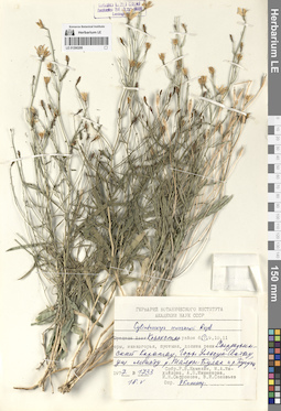
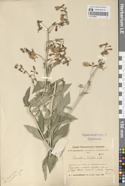
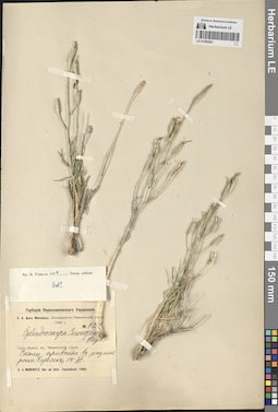
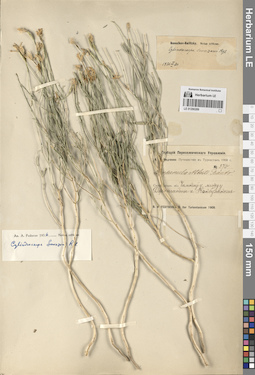
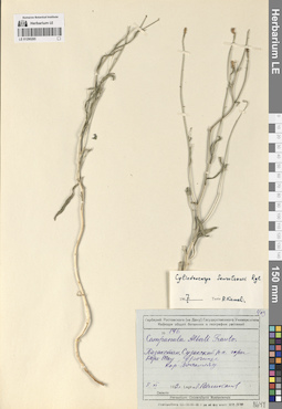
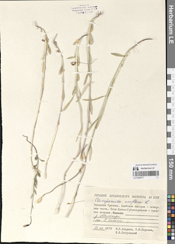
LE 01290299
Cylindrocarpa sewerzowii (Regel) Regel det. Kamelin, Rudolph Vladimirovich
Collectors: Kamelin, Rudolph Vladimirovich; Mikhajlova, Marina Аntonovna; Mishenkova, Antonina Petrovna; Safronova, Irina Nikolayevna; Soloviev, V.I. Field collecting number: 1733. Collection date: 18.05.1977. Administrative regions: KZ - Zhambyl Oblysy. Groups of specimens: Образцы сектора Средней АзииOriginal label text:Казахстан, Сырдарьинский Каратау. Горы Улькун-Актау, ущелье между рекой Талды-Булак и рекой Бугунь.
Coordinates (geographic position): 43° 22′ 47.06″ N, 69° 59′ 37.01″ EComment: № 1733
18.V.1977
Р. В. Камелин, М. А. Михайлова, А. П. Мишенкова, И. Н. Сафронова, В. И. Соловьев.
Kazakhstan, Syr Darya Karatau. Ulkun-Aktau Mountains, gorge between the Taldy-Bulak River and the Bugun River.
Record creation: 2024-08-04, Daria Yudova, PhotoScan D2.Citation: Specimen LE 01290299 // Virtual herbarium of Komarov Botanical Institute RAS — http://re.herbariumle.ru/01290299№ 1733
18.05.1977
Coll. R. V. Kamelin, M. A. Mikhajlova, A. P. Mishenkova, I. N. Safronova, V. I. Soloviov.
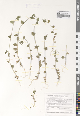
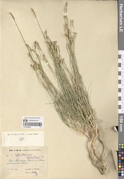
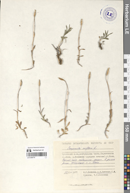
LE 01290426
Legousia falcata (Ten.) Fritsch
Collection date: 16.05.1979. Administrative regions: AM - Armenia. Groups of specimens: Образцы сектора Кавказа; Соглашение Минобрнауки №075-15-2021-1056Original label text:Армянская ССР, Мегринский район. Ущелье реки Шванидзор. Урочище Эхнакидзор. Арчевник.
Comment: 16.V.1979
Сагателян
Armenia. Meghri district. Shvanidzor River Gorge. Ehnakidzor.
Record creation: 2024-08-04, Daria Yudova, PhotoScan D2.Citation: Specimen LE 01290426 // Virtual herbarium of Komarov Botanical Institute RAS — http://re.herbariumle.ru/0129042616.05.1979
Coll. Sagatelyan
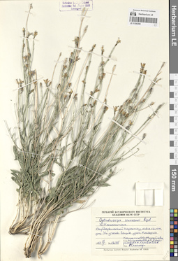
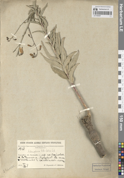
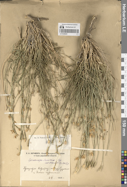
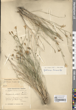
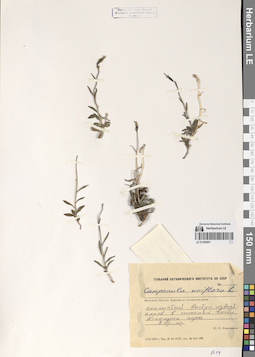
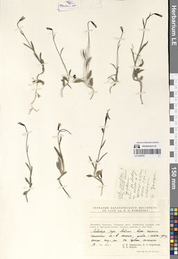
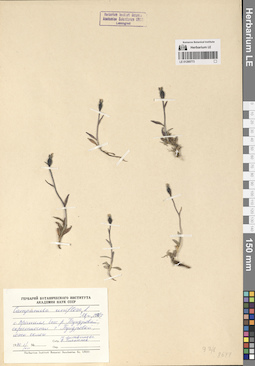
LE 01290298
Cylindrocarpa sewerzowii (Regel) Regel det. Kamelin, Rudolph Vladimirovich
Collectors: Kamelin, Rudolph Vladimirovich; Mikhajlova, Marina Аntonovna; Mishenkova, Antonina Petrovna; Safronova, Irina Nikolayevna; Soloviev, V.I. Field collecting number: 1235. Collection date: 11.05.1977. Administrative regions: KZ - South Kazakhstan - Tuerkistan Qalasy. Groups of specimens: Образцы сектора Средней АзииOriginal label text:Южный Казахстан. Сырдарьинский Каратау, южный склон, ущелье Уч-узень выше урочища Когашик.
Coordinates (geographic position): 43° 47′ 4.35″ N, 68° 4′ 58.38″ EComment: № 1235
11.V.1977
Камелин Р. В., Михайлова М. А., Мишенкова А. П., Сафронова И. Н, Соловьев В. И.
Southern Kazakhstan. Syr Darya Karatau, southern slope, Uch-Uzen gorge above Kogashik.
Record creation: 2024-08-04, Daria Yudova, PhotoScan D2.Citation: Specimen LE 01290298 // Virtual herbarium of Komarov Botanical Institute RAS — http://re.herbariumle.ru/01290298№ 1235
11.05.1977
Coll. Kamelin R.V., Mikhajlova M.A., Mishenkova A.P., Safronova I.N., Soloviov V.I.
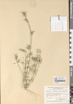
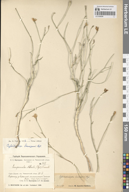
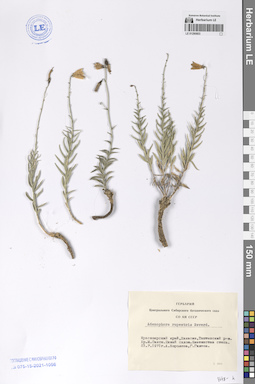
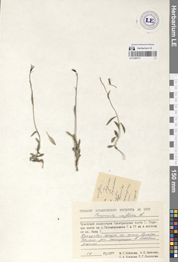
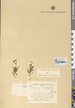
LE 01290425
Legousia falcata (Ten.) Fritsch det. Melnikov, Denis Germanovich
Collectors: Melnikov, Denis Germanovich Field collecting number: 35. Collection date: 12.06.2013. Administrative regions: GE - Abkhazia. Groups of specimens: Образцы сектора Кавказа; Соглашение Минобрнауки №075-15-2021-1056Original label text:Республика Абхазия, Гагрский район, северо-восточные окрестности поселка Цандрыпш, склон горы, луг у дороги. Высота примерно 150-200 м н.у.м.
Coordinates (geographic position): 43° 23′ 32.49″ N, 40° 3′ 49.37″ EComment: № 35
12.06.2013
Мельников Д. Г.
Republic of Abkhazia, Gagra district, north-eastern outskirts of the village of Tsandrypsh, mountain slope, meadow near the road. Height is approximately 150-200 m above sea level.
Record creation: 2024-08-04, Daria Yudova, PhotoScan D2.Citation: Specimen LE 01290425 // Virtual herbarium of Komarov Botanical Institute RAS — http://re.herbariumle.ru/01290425№ 35
12.06.2013
Coll. D. G. Melnikov
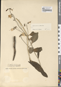
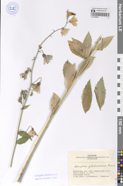
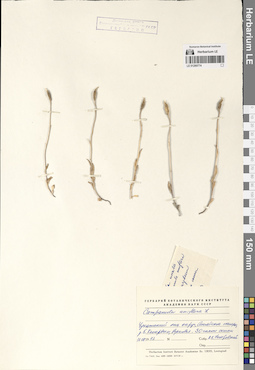
LE 01290297
Adenophora taurica (Sukaczev) Juz.
Additional identifications: Adenophora liliifolia (L.) A. DC. Collectors: Korotky, Mikhail Fedorovich; Lebedeva, Z. Field collecting number: 163. Collection date: 04.08.1913. Administrative regions: KZ - Qostanay Oblysy - Kustanayskiy Rayon. Groups of specimens: Образцы сектора Средней АзииOriginal label text:№ 163
Coordinates (geographic position): 52° 5′ 9.89″ N, 62° 41′ 18.56″ EComment: Тургайская область. Кустанайский уезд, окрестности поселка Смайловского. В долине озера Мукукуль. На солончаковатых и кочковатых местах.
4.VIII.1913
М. Короткий, З. Лебедева
№ 163
Record creation: 2024-08-04, Daria Yudova, PhotoScan D2.Citation: Specimen LE 01290297 // Virtual herbarium of Komarov Botanical Institute RAS — http://re.herbariumle.ru/01290297Turgay region. Kustanai district, vicinity of the village of Smailovsky. In the valley of Lake Mukukul. In saline and hummocky places.
4.08.1913
Coll. M. Korotky, Z. Lebedeva
LE 01290296
Adenophora taurica (Sukaczev) Juz.
Additional identifications: Adenophora liliifolia (L.) A. DC. Collectors: Krascheninnikov, Ippolit (Hippolit) Mikhailovich Field collecting number: 841. Collection date: 30.07.1908. Expedition: И. М. Крашенинников: Экспедиция в Тургайский уезд (1908) (1908)Groups of specimens: Образцы сектора Средней АзииOriginal label text:И. М. Крашенинников: Экспедиция в Тургайский уезд 1908 г.
Coordinates (geographic position): 51° 42′ 56.7″ N, 65° 6′ 18.44″ EComment: № 841
Тургайская область и уезд, 2-я Наурзумская волость.
Березовый лесок правого берега реки Кара-Теке около горы [Шок-Тумсук].
30.VII.
I. M. Krasheninnikov: Expedition to Turgai district 1908
Record creation: 2024-08-04, Daria Yudova, PhotoScan D2.Citation: Specimen LE 01290296 // Virtual herbarium of Komarov Botanical Institute RAS — http://re.herbariumle.ru/01290296№ 841
Turgay region and district, 2nd Naurzum volost. Birch forest on the right bank of the Kara-Teke River near the mountain [Shok-Tumsuk].
30.07.1908
Coll. I. M. Krasheninnikov
LE 01290295
Adenophora taurica (Sukaczev) Juz.
Additional identifications: Adenophora liliifolia (L.) A. DC. Collectors: Schipczinski, Nikolaj Valerianovich Field collecting number: 1206. Collection date: 02.07.1914. Administrative regions: KZ - Kazakhstan. Expedition: Шипчинский Н.В. Экспедиция в Семипалатинский уезд (1914 -1914)Groups of specimens: Образцы сектора Средней АзииOriginal label text:Н.В. Шипчинский: Экспедиция в Семипалатинский уезд 1914 г.
Coordinates (geographic position): 50° 2′ 38.47″ N, 81° 46′ 58.73″ EComment: № 1206
Семипалатинская область. Южная часть Семипалатинского уезда. Горы Дунгалы. В березняке в сыром ущелье.
2.VII.1914
N.V. Shipchinsky: Expedition to Semipalatinsk district 1914
Record creation: 2024-08-04, Daria Yudova, PhotoScan D2.Citation: Specimen LE 01290295 // Virtual herbarium of Komarov Botanical Institute RAS — http://re.herbariumle.ru/01290295№ 1206
Semipalatinsk region. Southern part of Semipalatinsk district. Dungaly mountains. In a birch forest in a damp gorge.
2.07.1914
Coll. N.V. Shipchinsky
LE 01290294
Adenophora sublata Kom. det. Fedorov, Andrey Aleksandrovich at 1954
Groups of specimens: Образцы сектора Средней АзииOriginal label text:Adenophora denticulata
Record creation: 2024-08-04, Daria Yudova, PhotoScan D2.Citation: Specimen LE 01290294 // Virtual herbarium of Komarov Botanical Institute RAS — http://re.herbariumle.ru/01290294Davuria.
LE 01290293
Cylindrocarpa sewerzowii (Regel) Regel
Collectors: Abramov, Vladimir Alekseevich Абрамов, Владимир Алексеевич Collection date: 04.06.1905. Administrative regions: KG - Jalal-Abad oblast - Suzak. Expedition: В.А. Абрамов: Флора Западного Тянь-Шаня и Сыр-дарьинской области ()Groups of specimens: Образцы сектора Средней АзииOriginal label text:В.А. Абрамов: Флора Западного Тянь-Шаня и Сыр-дарьинской области
Coordinates (geographic position): 43° 57′ 14.25″ N, 68° 49′ 21.17″ EComment: Предгорье Каратау - между Сузаком и Челак-курганом.
4.VI.1905
V.A. Abramov: Flora of the Western Tien Shan and Syr Darya region
Record creation: 2024-08-04, Daria Yudova, PhotoScan D2.Citation: Specimen LE 01290293 // Virtual herbarium of Komarov Botanical Institute RAS — http://re.herbariumle.ru/01290293Karatau foothills - between Suzak and Chelak-kurgan.
4.06.1905
Coll. V. A. Abramov
LE 01290292
Cylindrocarpa sewerzowii (Regel) Regel
Field collecting number: 23. Collection date: 08.08.1934. Groups of specimens: Образцы сектора Средней АзииOriginal label text:Горы Каратау. Ущелье реки Джилаганата. Скалы.
Comment: 8.VIII.1934
M. M. et E. M. Iljin
Karatau Mountains. Jilaganat River Gorge. Rocks.
Record creation: 2024-08-04, Daria Yudova, PhotoScan D2.Citation: Specimen LE 01290292 // Virtual herbarium of Komarov Botanical Institute RAS — http://re.herbariumle.ru/012902928.08.1934
Coll. M. M. and E. M. Iljin
LE 01290291
Cylindrocarpa sewerzowii (Regel) Regel
Collectors: Minkwitz, Zinaida Alexandrovna Field collecting number: 734. Collection date: 14.06.1908. Administrative regions: KZ - South Kazakhstan - Tuerkistan Qalasy. Expedition: З. А. фон Минквиц: Экспедиция в Чимкентский уезд // Z. a Minkwitz: Iter ad distr. Tschimkent (1908)Groups of specimens: Образцы сектора Средней АзииOriginal label text:Сыр-Дарьинская область. Чимкентский уезд. Скалы при входе в ущелье реки Бересек
Coordinates (geographic position): 43° 38′ 51.03″ N, 68° 38′ 1.21″ EComment: 14.VI.1908
З. А. фон Минквиц
Syr-Darya region. Chimkent district. Rocks at the entrance to the Beresek river gorge.
Record creation: 2024-08-04, Daria Yudova, PhotoScan D2.Citation: Specimen LE 01290291 // Virtual herbarium of Komarov Botanical Institute RAS — http://re.herbariumle.ru/0129029114.06.1908
Coll. Z. A. Minkwitz
LE 01290290
Cylindrocarpa sewerzowii (Regel) Regel det. Fedorov, Andrey Aleksandrovich at 1956
Collectors: Neustruev, Sergey Semyonovich; Dolenko, G. I. Field collecting number: 145. Collection date: 20.06.1908. Groups of specimens: Образцы сектора Средней АзииOriginal label text:Сыр-Дарьинская область, Чимкентский уезд. Каратау, у вершины каменистой сопки Кара-чеку (Черная гора).
Comment: 20.VI.1908
С. С. Неуструев, Г. И. Доленко
Syr-Darya region, Chimkent district. Karatau, at the top of the rocky hill Kara-cheku (Black Mountain).
Record creation: 2024-08-04, Daria Yudova, PhotoScan D2.Citation: Specimen LE 01290290 // Virtual herbarium of Komarov Botanical Institute RAS — http://re.herbariumle.ru/0129029020.06.1908
Coll. S. S. Neustruev, G. I. Dolenko
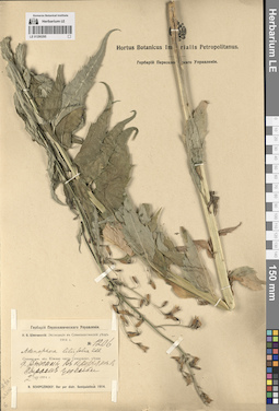
LE 01290289
Cylindrocarpa sewerzowii (Regel) Regel det. Fedorov, Andrey Aleksandrovich at 1956
Collectors: Fedtschenko, Boris Alexeevich Field collecting number: 370. Collection date: 1908. Administrative regions: KZ - Kazakhstan. Expedition: Федченко Б. А. Путешествие в Туркестан // B. A. Fedtschenko. Iter Turkestanicum (1908)Groups of specimens: Образцы сектора Средней АзииOriginal label text:Федченко Б. А. Путешествие в Туркестан 1908 г.
Comment: Сыр-Дарьинская область. Чимкентский уезд, между Джингакты и Какбулаком
№ 370
Fedchenko B. A. Journey to Turkestan 1908
Record creation: 2024-08-04, Daria Yudova, PhotoScan D2.Citation: Specimen LE 01290289 // Virtual herbarium of Komarov Botanical Institute RAS — http://re.herbariumle.ru/01290289Syr-Darya region. Chimkent district, between Dzhingakty and Kakbulak
№ 370
1908
Coll. B. A. Fedchenko
LE 01290288
Cylindrocarpa sewerzowii (Regel) Regel det. Fedorov, Andrey Aleksandrovich at 1956
Collectors: Fedtschenko, Boris Alexeevich Field collecting number: 396. Collection date: 15.06.1908. Administrative regions: KZ - Kazakhstan. Expedition: Федченко Б. А. Путешествие в Туркестан // B. A. Fedtschenko. Iter Turkestanicum (1908)Groups of specimens: Образцы сектора Средней АзииOriginal label text:Федченко Б. А. Путешествие в Туркестан 1908 г.
Comment: Сыр-Дарьинская область. Чимкентский уезд. От Как-булака до Биш-саз.
15 июня
Fedchenko B. A. Journey to Turkestan 1908
Record creation: 2024-08-04, Daria Yudova, PhotoScan D2.Citation: Specimen LE 01290288 // Virtual herbarium of Komarov Botanical Institute RAS — http://re.herbariumle.ru/01290288Syr-Darya region. Chimkent district. From Kak-bulak to Bish-saz.
15.06.1908
Coll. B. A. Fedtschenko
LE 01290287
Cylindrocarpa sewerzowii (Regel) Regel det. Kamelin, Rudolph Vladimirovich at 1974
Collectors: Goloskokov, Vitalii Petrovich Collection date: 23.05.1963. Administrative regions: KZ - Zhambyl Oblysy. Groups of specimens: Образцы сектора Средней АзииOriginal label text:Сырдарьинский Каратау. Ущелье реки Беркара (бассейн озера Бийликуль). На скалах, в трещинах.
Coordinates (geographic position): 42° 55′ 5.81″ N, 70° 38′ 5.88″ EComment: 23.V.1963
В. П. Голоскоков
Syrdarya Karatau. Gorge of the Berkara River (basin of Lake Biylikul). On rocks, in cracks.
Record creation: 2024-08-04, Daria Yudova, PhotoScan D2.Citation: Specimen LE 01290287 // Virtual herbarium of Komarov Botanical Institute RAS — http://re.herbariumle.ru/0129028723.05.1963
Coll. V. P. Goloskokov
LE 01290286
Cylindrocarpa sewerzowii (Regel) Regel det. Kamelin, Rudolph Vladimirovich at 1974
Collectors: Goloskokov, Vitalii Petrovich Collection date: 23.05.1963. Administrative regions: KZ - Zhambyl Oblysy. Groups of specimens: Образцы сектора Средней АзииOriginal label text:Сырдарьинский Каратау. Ущелье реки Беркара (бассейн озера Бийликуль). На скалах, в трещинах.
Coordinates (geographic position): 42° 55′ 5.81″ N, 70° 38′ 5.88″ EComment: 23.V.1963
В. П. Голоскоков
Syrdarya Karatau. Gorge of the Berkara River (basin of Lake Biylikul). On rocks, in cracks.
Record creation: 2024-08-04, Daria Yudova, PhotoScan D2.Citation: Specimen LE 01290286 // Virtual herbarium of Komarov Botanical Institute RAS — http://re.herbariumle.ru/0129028623.05.1963
Coll. V. P. Goloskokov
LE 01290285
Cylindrocarpa sewerzowii (Regel) Regel det. Kamelin, Rudolph Vladimirovich at 1967
Collectors: Velikanova Field collecting number: 146. Collection date: 08.06.1932. Administrative regions: KZ - Kazakhstan. Groups of specimens: Образцы сектора Средней АзииOriginal label text:№ 146
Comment: Казахстан, Сузакский район, горы Каратау, урочище Кор-Джайляу.
8.VI.1932
Л. Великанова
№ 146
Record creation: 2024-08-04, Daria Yudova, PhotoScan D2.Citation: Specimen LE 01290285 // Virtual herbarium of Komarov Botanical Institute RAS — http://re.herbariumle.ru/01290285Kazakhstan, Suzak district, Karatau mountains, Kor-Dzhailyau tract.
8.06.1932
Coll. Velikanova
LE 01290804
Adenophora golubinzevaeana Reverd.
Collectors: Neyfeld, I.; Vlassova, G. Collection date: 09.08.1968. Administrative regions: RU - Respublika Khakasiya - Shirinskiy Rayon. Groups of specimens: Образцы сектора Сибири и Дальнего Востока РоссииOriginal label text:Хакасская автономная область, Ширинский район, окрестности села Ключи, озеро Белё. Березовый лесок.
Coordinates (geographic position): 54° 43′ 19.32″ N, 90° 4′ 8.18″ EComment: 9.VIII.1968
И. Нейфельд, Г. Власова
Khakassia, Shirinsky District, the outskirts of the Klyuchi village, Lake Bele. Birch forest.
9.08.1968
Coll. I. Neyfeld, G. Vlassova
LE 01290803
Adenophora rupestris Reverd.
Collection date: 23.07.1971. Administrative regions: RU - Respublika Khakasiya. Groups of specimens: Образцы сектора Сибири и Дальнего Востока РоссииOriginal label text:Красноярский край, Хакасия, Таштыпский район. Хребет Малый Саксы[р]. Южный склон. Каменистая степь.
Coordinates (geographic position): 53° 30′ 44.32″ N, 90° 35′ 49.91″ EComment: 23.7.1971
А. Королева, Г. Гилева
Khakassia, Tashtypsky District. Maly Saksy[r] Ridge. Southern slope. Rocky steppe.
23.07.1971
Coll. A. Koroleva, G. Gileva
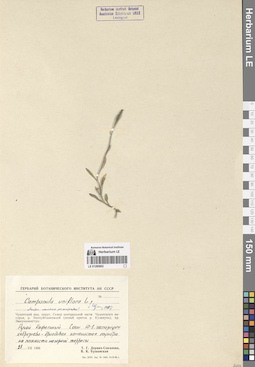
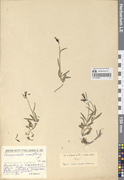
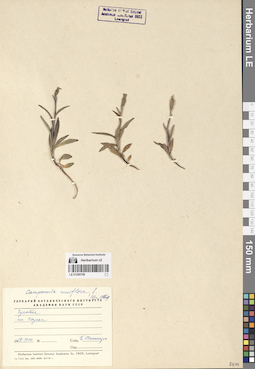
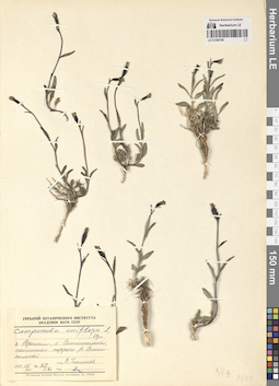
LE 01290802
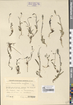
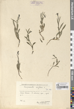
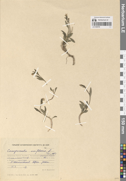
Campanula uniflora L.
Collectors: Derviz-Sokolova, Tatiana Georgievna; Bushanskaya, V.K. Collection date: 28.07.1966. Administrative regions: RU - Chukotskiy Avtonomnyy Okrug. Groups of specimens: Образцы сектора Сибири и Дальнего Востока РоссииOriginal label text:(Листья обильно реснитчатые)
Coordinates (geographic position): 69° 4′ 53.1″ N, 178° 28′ 12.96″ EComment: Чукотский национальный округ. Север центральной части Чукотского нагорья, река Экичуйгывеемкай (левый приток реки Куэквунь), хребет Эмнункэнигтун. Ручей Кафельный. Склон Ю-З экспозиции, кобрезиево-дриадовая каменистая тундра на плоскости нагорной террасы.
28.VII.1966
Т. Г. Дервиз-Соколова, В. К. Бушанская
(The leaves are abundantly ciliated) Chukotka National Okrug. North of the central part of the Chukotka Plateau, the Ekichuygyveemkay River (left tributary of the Kuekvun River), the Emnunkenigtun Ridge. Kafelny Creek. Slope of south-west exposure, kobresia-dryad rocky tundra on the plane of the mountain terrace.
28.07.1966
Coll. T. G. Derviz-Sokolova, V. K. Bushanskaya
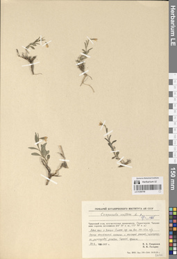
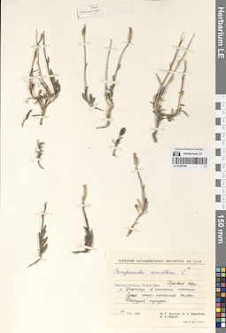
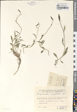
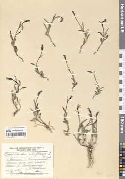
LE 01290801
Campanula uniflora L.
Collectors: Kozhevnikov, Yury Pavlovich Collection date: 08.08.1972. Administrative regions: RU - Chukotskiy Avtonomnyy Okrug. Groups of specimens: Образцы сектора Сибири и Дальнего Востока РоссииOriginal label text:Восточная Чукотка. Верховья реки Гытхытхвэоуваам.
Coordinates (geographic position): 67° 9′ 11.67″ N, 178° 5′ 3.13″ WComment: Скалистый выступ известняков в нижней части N склона горы.
8.VIII.1972
Ю. П. Кожевников
Eastern Chukotka. Upper reaches of the Gytkhytkhveouvaam River. A rocky limestone outcrop at the bottom of the N slope of the mountain.
Record creation: 2024-08-04, Daria Yudova, PhotoScan D2.Citation: Specimen LE 01290801 // Virtual herbarium of Komarov Botanical Institute RAS — http://re.herbariumle.ru/012908018.08.1972
Coll. Yu. P. Kozhevnikov
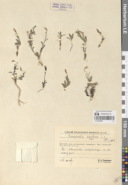
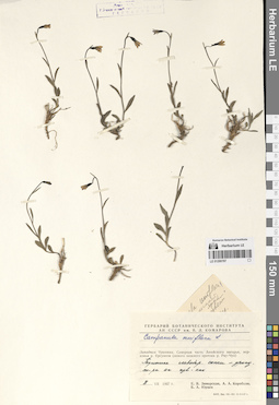
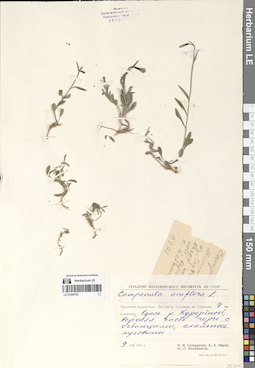
LE 01290800
Campanula uniflora L.
Collectors: Gorodkov, Boris Nikolaevich Collection date: 20.08.1938. Administrative regions: RU - Chukotskiy Avtonomnyy Okrug. Groups of specimens: Образцы сектора Сибири и Дальнего Востока РоссииOriginal label text:Дальний Восток. Остров Врангеля. Верховья реки Красный Флаг. Сухая лишайниково-моховая терраса в долине речки.
Coordinates (geographic position): 71° 17′ 14.73″ N, 178° 49′ 24.99″ WComment: 20.VIII.1938
Б. Н. Городков
Far East. Wrangel Island. Upper reaches of the Krasny Flag River. Dry lichen-moss terrace in the river valley.
Record creation: 2024-08-04, Daria Yudova, PhotoScan D2.Citation: Specimen LE 01290800 // Virtual herbarium of Komarov Botanical Institute RAS — http://re.herbariumle.ru/0129080020.08.1938
Coll. B. N. Gorodkov
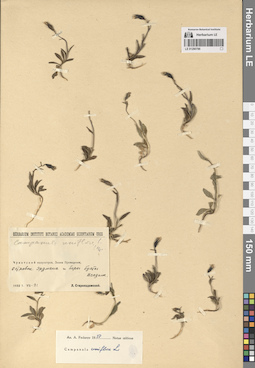
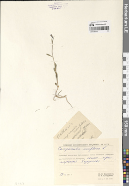
LE 01290799
Campanula uniflora L.
Collectors: Gavrilyuk, Victor Antonovich; Gagarin, P.K. Collection date: 30.06.1957. Administrative regions: RU - Chukotskiy Avtonomnyy Okrug. Groups of specimens: Образцы сектора Сибири и Дальнего Востока РоссииOriginal label text:Чукотский полуостров, юго-восточная оконечность. Окрестности Чаплинских горячих источников (64° 25' с. ш., 172° 30' з. д.). Левый берег реки Ульхум. Склоны гор на высоте 100-150 м н.у.м. Хорошо обогреваемый солнцем и заросший растительностью (кустарнички, разнотравье) участок. Хороший дренаж.
Coordinates (geographic position): 64° 26′ 9.16″ N, 172° 30′ 47.07″ WComment: 30.06.1957
В. А. Гаврилюк, П. К. Гагарин
Chukotka Peninsula, southeastern end. The area around the Chaplinsky hot springs (64° 25' N, 172° 30' W). Left bank of the Ulkhum River. Mountain slopes at an altitude of 100-150 m above sea level. An area well heated by the sun and overgrown with vegetation (shrubs, herbs). Good drainage.
Record creation: 2024-08-04, Daria Yudova, PhotoScan D2.Citation: Specimen LE 01290799 // Virtual herbarium of Komarov Botanical Institute RAS — http://re.herbariumle.ru/0129079930.06.1957
Coll. V. A. Gavrilyuk, P. K. Gagarin
LE 01290798
Campanula uniflora L.
Collectors: Tikhomirov, Boris Anatolievich Collection date: 17.08.1958. Administrative regions: RU - Chukotskiy Avtonomnyy Okrug. Groups of specimens: Образцы сектора Сибири и Дальнего Востока РоссииOriginal label text:Чукотка. Поселок Наукан.
Coordinates (geographic position): 66° 1′ 31.44″ N, 169° 42′ 27.69″ WComment: 17.VIII.1958
Б. Тихомиров
Chukotka. Naukan village.
Record creation: 2024-08-04, Daria Yudova, PhotoScan D2.Citation: Specimen LE 01290798 // Virtual herbarium of Komarov Botanical Institute RAS — http://re.herbariumle.ru/0129079817.08.1958
Coll. B. Tikhomirov
LE 01290797
Campanula uniflora L.
Collectors: Gavrilyuk, Victor Antonovich Collection date: 25.07.1957. Administrative regions: RU - Chukotskiy Avtonomnyy Okrug. Groups of specimens: Образцы сектора Сибири и Дальнего Востока РоссииOriginal label text:Чукотский полуостров, юго-восточная оконечность. Мыс Чаплина (64° 24' с. ш., 172° 12' з. д.), окрестности. На склонах горы к Чаплинскому озеру, 1,5-2 км от последнего.
Coordinates (geographic position): 64° 26′ 11.48″ N, 172° 26′ 50.86″ WComment: 25.VII.1957
В. А. Гаврилюк
Chukotka Peninsula, southeastern end. Cape Chaplin (64° 24' N, 172° 12' W), surroundings. On the slopes of the mountain to Lake Chaplinskoye, 1.5-2 km from the latter.
Record creation: 2024-08-04, Daria Yudova, PhotoScan D2.Citation: Specimen LE 01290797 // Virtual herbarium of Komarov Botanical Institute RAS — http://re.herbariumle.ru/0129079725.07.1957
Coll. V. A. Gavrilyuk
LE 01290796
Campanula uniflora L.
Collectors: Gavrilyuk, Victor Antonovich Collection date: 06.07.1957. Administrative regions: RU - Chukotskiy Avtonomnyy Okrug. Groups of specimens: Образцы сектора Сибири и Дальнего Востока РоссииOriginal label text:Чукотский полуостров, юго-восточная оконечность. Мыс Чаплина (64° 24' с. ш., 172° 12' з. д.). На повышениях микрорельефа по ЮВ склону горы.
Coordinates (geographic position): 64° 24′ 19.01″ N, 172° 33′ 26.84″ WComment: 6.VII.1957
В. А. Гаврилюк
Chukotka Peninsula, southeastern end. Mys Chaplin (64° 24' N, 172° 12' W). On the elevations of the microrelief along the southeastern slope of the mountain.
Record creation: 2024-08-04, Daria Yudova, PhotoScan D2.Citation: Specimen LE 01290796 // Virtual herbarium of Komarov Botanical Institute RAS — http://re.herbariumle.ru/012907966.07.1957
Coll. V. A. Gavrilyuk
LE 01290795
Campanula uniflora L.
Collectors: Gavrilyuk, Victor Antonovich Collection date: 25.08.1957. Administrative regions: RU - Chukotskiy Avtonomnyy Okrug. Groups of specimens: Образцы сектора Сибири и Дальнего Востока РоссииOriginal label text:Чукотский полуостров, юго-восточная оконечность. Мыс Чаплина (64° 24' с. ш., 172° 12' з. д.). На галечнике в устье реки, близ берега моря.
Coordinates (geographic position): 64° 22′ 55.75″ N, 172° 33′ 24.03″ WComment: 25.VIII.1957
В. А. Гаврилюк
Chukotka Peninsula, southeastern end. Mys Chaplin (64° 24' N, 172° 12' W). On the gravel at the mouth of the river, near the seashore.
Record creation: 2024-08-04, Daria Yudova, PhotoScan D2.Citation: Specimen LE 01290795 // Virtual herbarium of Komarov Botanical Institute RAS — http://re.herbariumle.ru/0129079525.08.1957
Coll. V. A. Gavrilyuk
LE 01290794
Campanula uniflora L.
Collectors: Gavrilyuk, Victor Antonovich Collection date: 06.07.1957. Administrative regions: RU - Chukotskiy Avtonomnyy Okrug. Groups of specimens: Образцы сектора Сибири и Дальнего Востока РоссииOriginal label text:Чукотский полуостров, юго-восточная оконечность. Мыс Чаплина (64° 24' с. ш., 172° 12' з. д.). На склоне горы, возле норы евражки.
Coordinates (geographic position): 64° 26′ 24.26″ N, 172° 27′ 31.37″ WComment: 6.VII.1957
В. А. Гаврилюк
Chukotka Peninsula, southeastern end. Cape Chaplin (64° 24' N, 172° 12' W). On the mountainside, near a squirrel's burrow.
Record creation: 2024-08-04, Daria Yudova, PhotoScan D2.Citation: Specimen LE 01290794 // Virtual herbarium of Komarov Botanical Institute RAS — http://re.herbariumle.ru/012907946.07.1957
Coll. V. A. Gavrilyuk
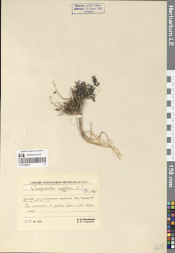
LE 01290793
Campanula uniflora L.
Field collecting number: 43. Collection date: 18.07.1954. Administrative regions: RU - Chukotskiy Avtonomnyy Okrug. Groups of specimens: Образцы сектора Сибири и Дальнего Востока РоссииOriginal label text:Остров Врангеля, мыс Флоренс, 16 км к N, терраса реки.
Coordinates (geographic position): 71° 18′ 16.13″ N, 179° 15′ 56.06″ EComment: № 43
18.VII.1954
[...]
Wrangel Island, Cape Florence, 16 km to the N, river terrace.
Record creation: 2024-08-04, Daria Yudova, PhotoScan D2.Citation: Specimen LE 01290793 // Virtual herbarium of Komarov Botanical Institute RAS — http://re.herbariumle.ru/01290793№ 43
18.07.1954
Coll. [...]
LE 01290792
Campanula uniflora L.
Collectors: Gavrilyuk, Victor Antonovich Collection date: 15.07.1962. Administrative regions: RU - Chukotskiy Avtonomnyy Okrug. Groups of specimens: Образцы сектора Сибири и Дальнего Востока РоссииOriginal label text:Чукотский национальный округ, город Анадырь, в В от аэропорта (в 2-3 км). На склоне щебнистого холма.
Coordinates (geographic position): 64° 42′ 51.34″ N, 177° 47′ 16.5″ EComment: 15.VII.1962
В. Гаврилюк
Chukotka National Okrug, the city of Anadyr, in the east from the airport (2-3 km). On the slope of a gravelly hill.
Record creation: 2024-08-04, Daria Yudova, PhotoScan D2.Citation: Specimen LE 01290792 // Virtual herbarium of Komarov Botanical Institute RAS — http://re.herbariumle.ru/0129079215.07.1962
Coll. V. Gavrilyuk
LE 01290791
Campanula uniflora L.
Administrative regions: RU - Chukotskiy Avtonomnyy Okrug. Groups of specimens: Образцы сектора Сибири и Дальнего Востока РоссииRecord creation: 2024-08-04, Daria Yudova, PhotoScan D2.Citation: Specimen LE 01290791 // Virtual herbarium of Komarov Botanical Institute RAS — http://re.herbariumle.ru/01290791
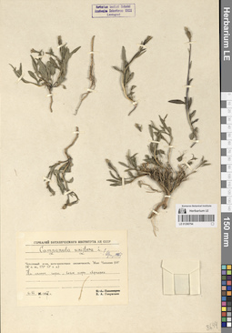
LE 01290790
Campanula uniflora L.
Field collecting number: 43. Collection date: 18.07.1954. Administrative regions: RU - Chukotskiy Avtonomnyy Okrug. Groups of specimens: Образцы сектора Сибири и Дальнего Востока РоссииOriginal label text:Остров Врангеля - западный берег к северу от мыса Флоренс (15-16 км). Прибрежная равнина. Надпойменная терраса в широкой долине речки.
Coordinates (geographic position): 71° 18′ 22.16″ N, 179° 15′ 58.27″ EComment: Растение № 43 (колокольчик)
цветы лиловые
18 июля 1954 г.
[...]
Wrangel Island - the western coast north of Cape Florence (15-16 km). Coastal plain. Floodplain terrace in a wide river valley.
Record creation: 2024-08-04, Daria Yudova, PhotoScan D2.Citation: Specimen LE 01290790 // Virtual herbarium of Komarov Botanical Institute RAS — http://re.herbariumle.ru/01290790lilac flowers
18.07.1954
Coll. [...]
LE 01290789
Campanula uniflora L.
Collectors: Tikhomirov, Boris Anatolievich Collection date: 09.07.1958. Administrative regions: RU - Chukotskiy Avtonomnyy Okrug. Groups of specimens: Образцы сектора Сибири и Дальнего Востока РоссииOriginal label text:Чукотский полуостров, бухта Эмма (64° 30' с. ш., 172° 30' з. д.). Ясная Поляна. У подножья горы, луговинный участок.
Coordinates (geographic position): 64° 26′ 35.85″ N, 173° 9′ 54.59″ WComment: 9.VII.1958
Б. А. Тихомиров
Chukotka Peninsula, Emma Bay (64° 30' N, 172° 30' W). Yasnaya Polyana. At the foot of the mountain, a meadow area.
Record creation: 2024-08-04, Daria Yudova, PhotoScan D2.Citation: Specimen LE 01290789 // Virtual herbarium of Komarov Botanical Institute RAS — http://re.herbariumle.ru/012907899.07.1958
Coll. B. A. Tikhomirov
LE 01290788
Campanula uniflora L.
Collectors: Levichev, Igor Germanovich; Korobkov, Aleksandr Aleksandrovich; Jurtzev, Boris Alexandrovich Collection date: 11.08.1968. Administrative regions: RU - Chukotskiy Avtonomnyy Okrug. Groups of specimens: Образцы сектора Сибири и Дальнего Востока РоссииOriginal label text:Западная Чукотка. Остров Айон. Правый берег реки Утатгыр в нижнем течении. Сухой южный песчаный склон. Кобрезиевая тундра.
Coordinates (geographic position): 69° 53′ 6.45″ N, 167° 54′ 55.9″ EComment: 11.VIII.1968
И. Г. Левичев, А. А. Коробков, Б. А. Юрцев
Western Chukotka. Ayon Island. Right bank of the Utatgyr River in the lower reaches. Dry southern sandy slope. Kobresia tundra.
Record creation: 2024-08-04, Daria Yudova, PhotoScan D2.Citation: Specimen LE 01290788 // Virtual herbarium of Komarov Botanical Institute RAS — http://re.herbariumle.ru/0129078811.08.1968
Coll. I. G. Levichev, A. A. Korobkov, B. A. Jurtzev
LE 01290787
Campanula uniflora L.
Collectors: Zimarskaya, Ekaterina V.; Korobkov, Aleksandr Aleksandrovich; Jurtzev, Boris Alexandrovich Collection date: 08.07.1967. Administrative regions: RU - Chukotskiy Avtonomnyy Okrug. Groups of specimens: Образцы сектора Сибири и Дальнего Востока РоссииOriginal label text:Западная Чукотка. Северная часть Анюйского нагорья, верховья реки Ергувеем (левого нижнего притока реки Рау-Чуа). Подножье левобережной сопки - дриадовая тундра на известняках.
Coordinates (geographic position): 69° 11′ 19.16″ N, 165° 37′ 6.27″ EComment: 8.VII.1967
Е. В. Зимарская, А. А. Коробков, Б. А. Юрцев
Western Chukotka. Northern part of the Anyui plateau, upper reaches of the Erguveem river (left lower tributary of the Rau-Chua river). The foot of the left-bank hill is dryad tundra on limestone.
Record creation: 2024-08-04, Daria Yudova, PhotoScan D2.Citation: Specimen LE 01290787 // Virtual herbarium of Komarov Botanical Institute RAS — http://re.herbariumle.ru/012907878.07.1967
Coll. E. V. Zimarskaya, A. A. Korobkov, B. A. Jurtzev.
LE 01290786
Campanula uniflora L. det. Fedorov, Andrey Aleksandrovich at 1953
Collectors: Starokadomsky, Leonid Mikhailovich Collection date: 21.07.1932. Administrative regions: RU - Chukotskiy Avtonomnyy Okrug. Groups of specimens: Образцы сектора Сибири и Дальнего Востока РоссииOriginal label text:Чукотский полуостров. Залив Провидения. Островок Эрдмана и берег бухты Всадник.
Coordinates (geographic position): 64° 33′ 24.43″ N, 173° 17′ 59.29″ WComment: 21.VII.1932
Л. Старокадомский
Chukotka Peninsula. Providence Bay. Erdman Island and the shore of Vsadnik Bay.
Record creation: 2024-08-04, Daria Yudova, PhotoScan D2.Citation: Specimen LE 01290786 // Virtual herbarium of Komarov Botanical Institute RAS — http://re.herbariumle.ru/0129078621.07.1932
Coll. L. Starokadomsky
LE 01290785
Campanula uniflora L.
Collectors: Kozhevnikov, Yury Pavlovich Collection date: 15.07.1972. Administrative regions: RU - Chukotskiy Avtonomnyy Okrug. Groups of specimens: Образцы сектора Сибири и Дальнего Востока РоссииOriginal label text:Центральная Чукотка. Бассейн реки Чантальвеергын. Река Чантальвеергын в 40 км от устья. N скалистый берег реки.
Coordinates (geographic position): 67° 56′ 2.28″ N, 179° 57′ 10.63″ WComment: 15.07.1972
Ю. П. Кожевников
Central Chukotka. Chantalveergyn River basin. Chantalveergyn River 40 km from its mouth. N rocky river bank.
Record creation: 2024-08-04, Daria Yudova, PhotoScan D2.Citation: Specimen LE 01290785 // Virtual herbarium of Komarov Botanical Institute RAS — http://re.herbariumle.ru/0129078515.07.1972
Coll. Yu. P. Kozhevnikov
LE 01290784
Campanula uniflora L.
Collectors: Kozhevnikov, Yury Pavlovich; Sukhorukova, N. I.; Efros, A. L. Collection date: 30.07.1971. Administrative regions: RU - Chukotskiy Avtonomnyy Okrug. Groups of specimens: Образцы сектора Сибири и Дальнего Востока РоссииOriginal label text:Восточная Чукотка. Чукотское нагорье, южные отроги хребта Искатень, побережье залива Креста близ поселка Эгвекинот. Скалы в долине речки близ аэропорта.
Coordinates (geographic position): 66° 22′ 14.11″ N, 179° 8′ 25.64″ WComment: 30.VII.1971
Ю. Кожевников, Н. Сухорукова, А. Эфрос
Eastern Chukotka. Chukotka Highlands, southern spurs of the Iskateni Ridge, the coast of Kresta Bay near the village of Egvekinot. Cliffs in the river valley near the airport.
30.07.1971
Coll. Yu. Kozhevnikov, N. Sukhorukova, A. Efros
LE 01290783
Campanula uniflora L.
Collectors: Sukhorukova, N. I.; Efros, A. L.; Kozhevnikov, Yury Pavlovich Collection date: 09.07.1971. Administrative regions: RU - Chukotskiy Avtonomnyy Okrug. Groups of specimens: Образцы сектора Сибири и Дальнего Востока РоссииOriginal label text:Чукотский полуостров. Бассейн реки Сеутакан, озеро Сеутакан, 7 км к востоку, вдоль реки Курортной, верхняя часть горы с останцами, скальные луговины.
Coordinates (geographic position): 65° 45′ 59.65″ N, 176° 37′ 23.61″ WComment: 9.VII.1971
Н. И. Сухорукова, А. Л. Эфрос, Ю. П. Кожевников
Chukotka Peninsula. Seutakan River basin, Seutakan Lake, 7 km to the east, along the Kurortnaya River, upper part of the mountain with outliers, rocky meadows.
Record creation: 2024-08-04, Daria Yudova, PhotoScan D2.Citation: Specimen LE 01290783 // Virtual herbarium of Komarov Botanical Institute RAS — http://re.herbariumle.ru/012907839.07.1971
Coll. N. I. Sukhorukova, A. L. Efros, Yu. P. Kozhevnikov
LE 01290782
Campanula uniflora L.
Collectors: Kozhevnikov, Yury Pavlovich; Sukhorukova, N. I. Collection date: 15.07.1971. Administrative regions: RU - Chukotskiy Avtonomnyy Okrug. Groups of specimens: Образцы сектора Сибири и Дальнего Востока РоссииOriginal label text:Чукотский полуостров (юго-западная часть). Восточное побережье залива Креста близ поселка Конергино, склон приморской террасы.
Coordinates (geographic position): 65° 53′ 21.97″ N, 178° 49′ 44.98″ WComment: 15.VII.1971
Ю. П. Кожевников, Н. И. Сухорукова
Chukotka Peninsula (southwestern part). The eastern coast of Kresta Bay near the village of Konergino, the slope of the seaside terrace.
Record creation: 2024-08-04, Daria Yudova, PhotoScan D2.Citation: Specimen LE 01290782 // Virtual herbarium of Komarov Botanical Institute RAS — http://re.herbariumle.ru/0129078215.07.1971
Coll. Yu. P. Kozhevnikov, N. I. Sukhorukova
LE 01290781
Campanula uniflora L.
Collectors: Zimarskaya, Ekaterina V.; Korobkov, Aleksandr Aleksandrovich; Jurtzev, Boris Alexandrovich Collection date: 09.07.1967. Administrative regions: RU - Chukotskiy Avtonomnyy Okrug. Groups of specimens: Образцы сектора Сибири и Дальнего Востока РоссииOriginal label text:Западная Чукотка. Северная часть Анюйского нагорья, верховья реки Ергувеем (левого нижнего притока реки Рау-Чуа). Левобережье ручья Ловкого, верхняя часть пологого Ю-В склона, щебн.-пятн.-дриад.-осочк. тундра на известняковых сланцах.
Comment: 9.VII.1967
Е. В. Зимарская, А. А. Коробков, Б. А. Юрцев
Western Chukotka. Northern part of the Anyui plateau, upper reaches of the Erguveem River (left lower tributary of the Rau-Chua River). Left bank of the Lovky Creek, upper part of the gentle SE slope, tundra on limestone shales.
Record creation: 2024-08-04, Daria Yudova, PhotoScan D2.Citation: Specimen LE 01290781 // Virtual herbarium of Komarov Botanical Institute RAS — http://re.herbariumle.ru/012907819.07.1967
Coll. E. V. Zimarskaya, A. A. Korobkov, B. A. Jurtzev
LE 01290780
Campanula uniflora L.
Collectors: Tikhmenev, E. A. Field collecting number: 32/170. Collection date: 13.07.1971. Administrative regions: RU - Chukotskiy Avtonomnyy Okrug. Groups of specimens: Образцы сектора Сибири и Дальнего Востока РоссииOriginal label text:Остров Врангеля, бухта Сомнительная, пойменная терраса реки Сомнительной.
Coordinates (geographic position): 70° 56′ 43.73″ N, 179° 36′ 27.59″ WComment: № 32/170
13.VII.1971
Е. Тихменев
Wrangel Island, Somnitelnaya Bay, floodplain terrace of the Somnitelnaya River.
Record creation: 2024-08-04, Daria Yudova, PhotoScan D2.Citation: Specimen LE 01290780 // Virtual herbarium of Komarov Botanical Institute RAS — http://re.herbariumle.ru/01290780№ 32/170
13.07.1971
Coll. E. Tikhmenev
LE 01290779
Campanula uniflora L.
Collectors: Tikhmenev, E. A.; Levkovsky, V. Field collecting number: 72/196. Collection date: 14.07.1971. Administrative regions: RU - Chukotskiy Avtonomnyy Okrug. Groups of specimens: Образцы сектора Сибири и Дальнего Востока РоссииOriginal label text:Остров Врангеля, бухта Сомнительная. Южный склон гор правобережья реки Сомнительной.
Coordinates (geographic position): 70° 58′ 51.6″ N, 179° 33′ 28.93″ WComment: № 72/196
14.VII.1971
Е. Тихменев, В. Левковский
Wrangel Island, Somnitelnaya Bay. Southern slope of the mountains on the right bank of the Somnitelnaya River.
Record creation: 2024-08-04, Daria Yudova, PhotoScan D2.Citation: Specimen LE 01290779 // Virtual herbarium of Komarov Botanical Institute RAS — http://re.herbariumle.ru/01290779№ 72/196
14.07.1971
Coll. E. Tikhmenev, V. Levkovsky
LE 01290778
Campanula uniflora L.
Collectors: Sekretareva, Nadezhda Alexandrovna; Sytin, Andrej Kirillovich; Jurtzev, Boris Alexandrovich Collection date: 15.07.1971. Administrative regions: RU - Chukotskiy Avtonomnyy Okrug. Groups of specimens: Образцы сектора Сибири и Дальнего Востока РоссииOriginal label text:Чукотский полуостров (восточная часть). Северо-западная оконечность залива Лаврентия близ мыса Краузе. 2 км к ЮВ от мыса Краузе, нивальная тундра над береговым снежником.
Coordinates (geographic position): 65° 47′ 16.01″ N, 171° 25′ 48.89″ WComment: 15.VII.1971
Н. А. Секретарева, А. К. Сытин, Б. А. Юрцев
Chukotka Peninsula (eastern part). Northwestern end of the Gulf of Lavrentiya near Cape Krause. 2 km SE of Cape Krause, nival tundra above coastal snowfield.
Record creation: 2024-08-04, Daria Yudova, PhotoScan D2.Citation: Specimen LE 01290778 // Virtual herbarium of Komarov Botanical Institute RAS — http://re.herbariumle.ru/0129077815.07.1971
Coll. N. A. Sekretareva, A. K. Sytin, B. A. Jurtzev
LE 01290777
Campanula uniflora L.
Collectors: Andreev, Mikhail Petrovich; Norkina, E. Yu.; Petrovsky, Vladislav Vladimirovich Collection date: 26.08.1977. Administrative regions: RU - Chukotskiy Avtonomnyy Okrug. Groups of specimens: Образцы сектора Сибири и Дальнего Востока РоссииOriginal label text:Западная Чукотка. Анюйское нагорье - северная часть. Река Кытеп-Гуйтеньрывеем - среднее течение. Река Милькера. На S склоне.
Coordinates (geographic position): 69° 17′ 37.51″ N, 165° 16′ 19.23″ EComment: 26.08.1977
М. П. Андреев, Е. Ю. Норкина, В. В. Петровский
Western Chukotka. Anyui Highland - northern part. Kytep-Guytenryveem River - middle course. Milkera River. On the S slope.
Record creation: 2024-08-04, Daria Yudova, PhotoScan D2.Citation: Specimen LE 01290777 // Virtual herbarium of Komarov Botanical Institute RAS — http://re.herbariumle.ru/0129077726.08.1977
Coll. M. P. Andreev, E. Yu. Norkina, V. V. Petrovsky
LE 01290776
Campanula uniflora L.
Collectors: Katenin, Adrian Evgenevich Collection date: 17.08.1977. Administrative regions: RU - Chukotskiy Avtonomnyy Okrug. Groups of specimens: Образцы сектора Сибири и Дальнего Востока РоссииOriginal label text:Чукотский полуостров, центральная часть. Окрестности озера Иони, река Ионивеем (среднее течение), гора Иони. Верхняя часть нивального уступа в долине речки, стекающей с горы Иони.
Coordinates (geographic position): 65° 56′ 11.65″ N, 173° 50′ 25.17″ WComment: 17.VIII.1977
А. Е. Катенин
Chukotka Peninsula, central part. Vicinity of Lake Ioni, Ioniveem River (middle reaches), Mount Ioni. Upper part of nival ledge in the valley of the river flowing down from Mount Ioni.
Record creation: 2024-08-04, Daria Yudova, PhotoScan D2.Citation: Specimen LE 01290776 // Virtual herbarium of Komarov Botanical Institute RAS — http://re.herbariumle.ru/0129077617.08.1977
Coll. A. E. Katenin
LE 01290775
Campanula uniflora L.
Collectors: Boitsova, M. S.; Katenin, Adrian Evgenevich; Krivova, S. A.; Polozova, Tamara Georgievna Collection date: 19.07.1977. Administrative regions: RU - Chukotskiy Avtonomnyy Okrug. Groups of specimens: Образцы сектора Сибири и Дальнего Востока РоссииOriginal label text:Чукотский полуостров (центральная часть). Горячие ключи на реке Гильмимливеем (в 15 км к востоку от озера Иони). Дриадовая тундра на сухом взлобке склона западной экспозиции в боковом ущелье.
Coordinates (geographic position): 65° 48′ 28.01″ N, 173° 21′ 26.36″ WComment: 19.VII.1977
М. С. Бойцова, А. Е. Катенин, С. А. Кривова, Т. Г. Полозова
Chukotka Peninsula (central part). Hot springs on the Gilmimliveyem River (15 km east of Lake Ioni). Dryad tundra on a dry hillside of a western exposure slope in a side gorge.
Record creation: 2024-08-04, Daria Yudova, PhotoScan D2.Citation: Specimen LE 01290775 // Virtual herbarium of Komarov Botanical Institute RAS — http://re.herbariumle.ru/0129077519.07.1977
Coll. M. S. Boitsova, A. E. Katenin, S. A. Krivova, T. G. Polozova
LE 01290774
Campanula uniflora L.
Collectors: Petrovsky, Vladislav Vladimirovich Collection date: 17.08.1973. Administrative regions: RU - Chukotskiy Avtonomnyy Okrug. Groups of specimens: Образцы сектора Сибири и Дальнего Востока РоссииOriginal label text:Чукотский национальный округ, Анюйское нагорье, река Большой Кепервеем, верховья. SO склон сопки.
Coordinates (geographic position): 68° 10′ 24.95″ N, 166° 39′ 23.87″ EComment: 17.08.1973
В. В. Петровский
Chukotka National Okrug, Anyui Highland, Bolshoy Keperveem River, upper reaches. SO slope of the hill.
Record creation: 2024-08-04, Daria Yudova, PhotoScan D2.Citation: Specimen LE 01290774 // Virtual herbarium of Komarov Botanical Institute RAS — http://re.herbariumle.ru/0129077417.08.1973
Coll. V. V. Petrovsky
LE 01290773
Campanula uniflora L.
Collectors: Litvinova, N.P.; Tikhmenev, E. A. Collection date: 01.08.1970. Administrative regions: RU - Chukotskiy Avtonomnyy Okrug. Groups of specimens: Образцы сектора Сибири и Дальнего Востока РоссииOriginal label text:Остров Врангеля, бассейн реки Тундровой, окрестности горы Тундровой, южный склон.
Coordinates (geographic position): 71° 18′ 20.64″ N, 179° 48′ 58.35″ WComment: 1.VIII.1970
Н. Литвинова, Е. Тихменев
Wrangel Island, Tundrovaya River basin, vicinity of Tundrovaya Mountain, southern slope.
Record creation: 2024-08-04, Daria Yudova, PhotoScan D2.Citation: Specimen LE 01290773 // Virtual herbarium of Komarov Botanical Institute RAS — http://re.herbariumle.ru/012907731.08.1970
Coll. N. Litvinova, E. Tikhmenev
LE 01290772
Campanula uniflora L.
Collectors: Borisow, G. A. Field collecting number: 156. Collection date: 04.07.1909. Administrative regions: RU - Chukotskiy Avtonomnyy Okrug. Groups of specimens: Образцы сектора Сибири и Дальнего Востока РоссииOriginal label text:Г. А. Борисов: Растения Чукотского полуострова 1909 г.
Coordinates (geographic position): 64° 25′ 41.12″ N, 173° 13′ 7.85″ WComment: Окрестности торговой станции Св. Владимира Северо-восточного Сибирского Общества, на берегу бухты Эммы в заливе Провидения 64° 45' N, 174° W (от Гринв.).
Склоны холмов по западному берегу бухты Эммы.
4.VII.
G. A. Borisov: Plants of the Chukotka Peninsula 1909
The environs of the trading station of St. Vladimir of the North-Eastern Siberian Society, on the shore of Emma Bay in Providence Bay 64° 45' N, 174° W (from Greenwich).
Slopes of hills along the western shore of Emma Bay.
4.07.1909
Coll. G. A. Borisov