View
Add
Copy
Edit
Delete
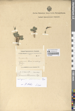
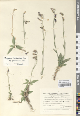
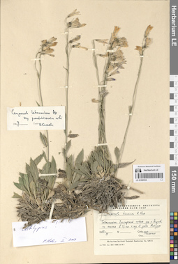
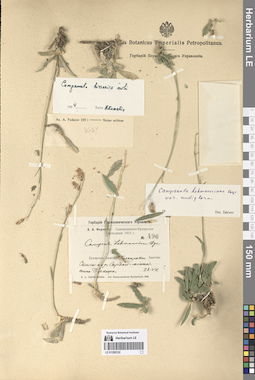
LE 01290349
Groups of specimens: Образцы сектора Средней АзииRecord creation: 2024-08-04, Daria Yudova, PhotoScan D2.Citation: Specimen LE 01290349 // Virtual herbarium of Komarov Botanical Institute RAS — http://re.herbariumle.ru/01290349
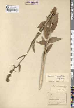
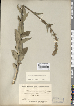
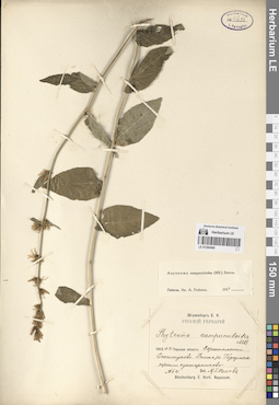
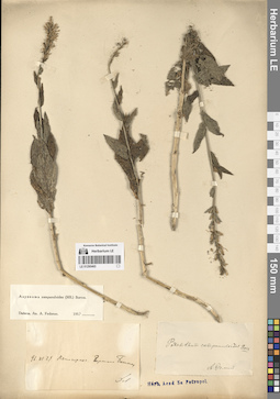
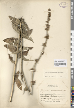
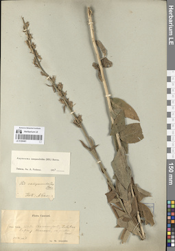
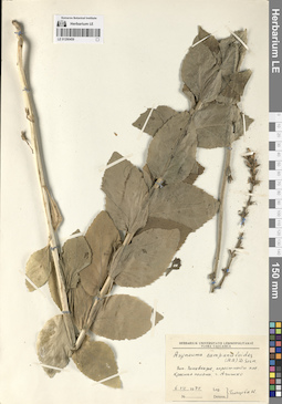
LE 01290477
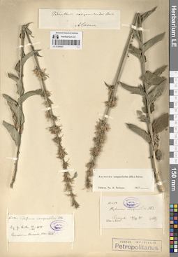
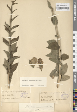
Asyneuma campanuloides (M. Bieb. ex Sims) Bornm. det. Fedorov, Andrey Aleksandrovich at 1963
Collectors: Sukaczev, Vladimir Nikolajevich; Sokolov, Sergey Yakovlevich Collection date: 23.08.1929. Administrative regions: RU - Krasnodarskiy Kray. Groups of specimens: Образцы сектора Кавказа; Соглашение Минобрнауки №075-15-2021-1056Original label text:Южная часть Черноморского Округа между Адлером и Туапсе.
Coordinates (geographic position): 43° 37′ 40.6″ N, 40° 17′ 13″ EComment: Адлерское лесничество, Муравьевская дача, гора Аибга. Северный склон. Субальпийская зона.
23.VIII.1929
В. Сукачев, С. Соколов
Krasnodarskiy Kray, Mount Aibga. Northern slope. Subalpine zone.
Record creation: 2024-08-04, Daria Yudova, PhotoScan D2.Citation: Specimen LE 01290477 // Virtual herbarium of Komarov Botanical Institute RAS — http://re.herbariumle.ru/0129047723.08.1929
Coll. V. Sukaczev, S. Sokolov
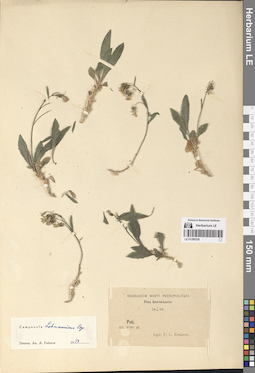
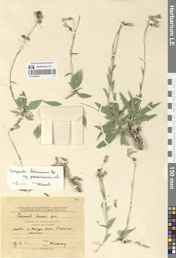
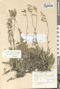
LE 01290348
Groups of specimens: Образцы сектора Средней АзииRecord creation: 2024-08-04, Daria Yudova, PhotoScan D2.Citation: Specimen LE 01290348 // Virtual herbarium of Komarov Botanical Institute RAS — http://re.herbariumle.ru/01290348
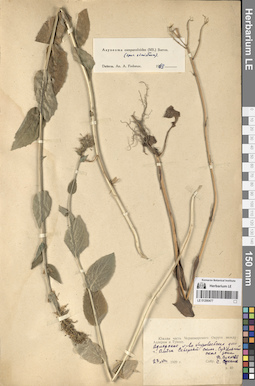
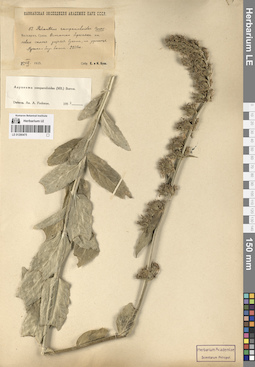
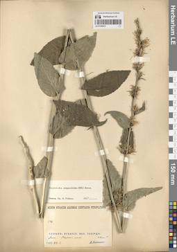
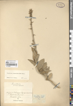
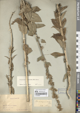
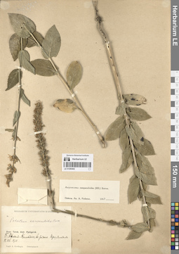
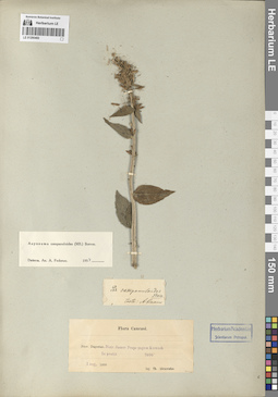
LE 01290476
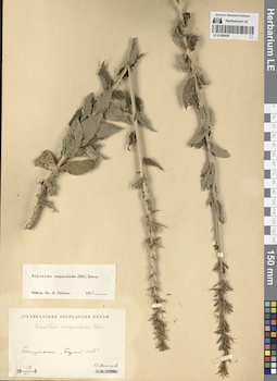
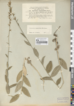
Asyneuma campanuloides (M. Bieb. ex Sims) Bornm. det. Fedorov, Andrey Aleksandrovich at 1964
Collectors: Marcowicz, Vasilii Vasilevicz Collection date: 10.07.1897. Administrative regions: RU - North Ossetia. Groups of specimens: Образцы сектора Кавказа; Соглашение Минобрнауки №075-15-2021-1056Original label text:Caucasus. Ossetia. In pratis agricis prope Mamison.
Coordinates (geographic position): 42° 39′ 37.93″ N, 43° 50′ 26.39″ ERecord creation: 2024-08-04, Daria Yudova, PhotoScan D2.Citation: Specimen LE 01290476 // Virtual herbarium of Komarov Botanical Institute RAS — http://re.herbariumle.ru/0129047610.VII.97
Marcowitch
LE 01290347
Groups of specimens: Образцы сектора Средней АзииRecord creation: 2024-08-04, Daria Yudova, PhotoScan D2.Citation: Specimen LE 01290347 // Virtual herbarium of Komarov Botanical Institute RAS — http://re.herbariumle.ru/01290347
LE 01290475
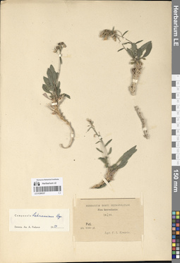
Asyneuma campanuloides (M. Bieb. ex Sims) Bornm. det. Fedorov, Andrey Aleksandrovich at 1954
Collectors: Busch, Elizaveta Aleksandrovna; Busch, Nikolai Adolfovich (Nikolaj Adolfowitsch) Collection date: 25.08.1925. Administrative regions: RU - Kabardino-Balkarskaya Respublika. Groups of specimens: Образцы сектора Кавказа; Соглашение Минобрнауки №075-15-2021-1056Original label text:Балкария, Сукан. Остатки березняка на левом склоне ущелья Сукана, на урочище Мусака-бау-баши. 2250 м.
Coordinates (geographic position): 2250 m a.s.l.Comment: 25.VIII.1925
Е. и Н. Буш
Balkaria, Sukan. Remains of a birch forest on the left slope of the Sukan gorge, on the Musaka-bau-bashi tract. 2250 m.
Record creation: 2024-08-04, Daria Yudova, PhotoScan D2.Citation: Specimen LE 01290475 // Virtual herbarium of Komarov Botanical Institute RAS — http://re.herbariumle.ru/0129047525.08.1925
Coll. E. Busch, N. Busch
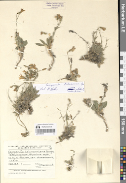
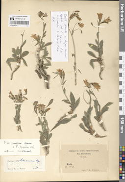
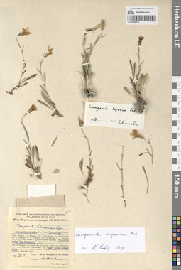
LE 01290346
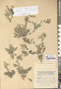
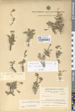
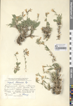
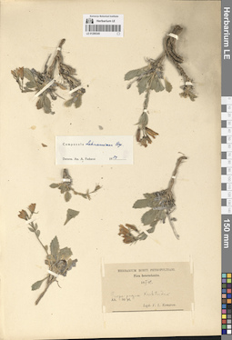
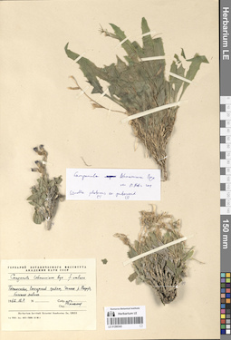
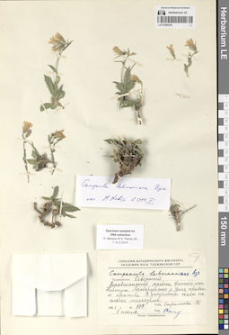
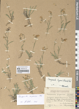
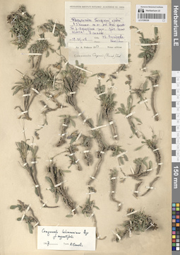
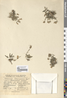
Campanula lehmanniana Bunge det. Kamelin, Rudolph Vladimirovich
Collectors: Kamelin, Rudolph Vladimirovich Collection date: 18.07.1965. Administrative regions: TJ - Tajikistan. Groups of specimens: Образцы сектора Средней АзииOriginal label text:Таджикистан, Фанские горы, озеро Кули-Калон, западная оконечность, скалы.
Coordinates (geographic position): 39° 15′ 13.24″ N, 68° 9′ 57.63″ EComment: 18.07.1965
Р. Камелин
Tajikistan, Fann Mountains, Kuli-Kalon Lake, western end, rocks.
Record creation: 2024-08-04, Daria Yudova, PhotoScan D2.Citation: Specimen LE 01290346 // Virtual herbarium of Komarov Botanical Institute RAS — http://re.herbariumle.ru/0129034618.07.1965
Coll. R. Kamelin
LE 01290474
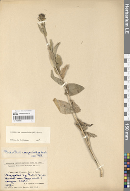
Asyneuma campanuloides (M. Bieb. ex Sims) Bornm. det. Fedorov, Andrey Aleksandrovich at 1954
Collectors: Busch, Elizaveta Aleksandrovna; Busch, Nikolai Adolfovich (Nikolaj Adolfowitsch) Field collecting number: 50. Collection date: 24.08.1925. Administrative regions: RU - Kabardino-Balkarskaya Respublika. Groups of specimens: Образцы сектора Кавказа; Соглашение Минобрнауки №075-15-2021-1056Original label text:Балкария, Сукан. Субальпийский луг на урочище Архы. 2250 м.
Coordinates (geographic position): 42° 58′ 24.42″ N, 43° 26′ 31.6″ E 2250 m a.s.l.Comment: 24.VIII.1925
Е. и Н. Буш
Balkaria, Sukan. Subalpine meadow on the Arkhy. 2250 m.
Record creation: 2024-08-04, Daria Yudova, PhotoScan D2.Citation: Specimen LE 01290474 // Virtual herbarium of Komarov Botanical Institute RAS — http://re.herbariumle.ru/0129047424.08.1925
Coll. E. Busch, N. Busch
LE 01290345
Groups of specimens: Образцы сектора Средней АзииRecord creation: 2024-08-04, Daria Yudova, PhotoScan D2.Citation: Specimen LE 01290345 // Virtual herbarium of Komarov Botanical Institute RAS — http://re.herbariumle.ru/01290345
LE 01290473
Asyneuma campanuloides (M. Bieb. ex Sims) Bornm. det. Fedorov, Andrey Aleksandrovich at 1954
Collectors: Litvinov, Dimitri Ivanovich Field collecting number: 146. Collection date: 02.07.1905. Groups of specimens: Образцы сектора Кавказа; Соглашение Минобрнауки №075-15-2021-1056Original label text:146.
Comment: Кавказ. Кубанская область. Теберда.
[Даш].Опушки леса.
1905.VII.2
Д. Литвинов
146. Caucasus. Kuban region. Teberda. [Dash]. Forest edges.
Record creation: 2024-08-04, Daria Yudova, PhotoScan D2.Citation: Specimen LE 01290473 // Virtual herbarium of Komarov Botanical Institute RAS — http://re.herbariumle.ru/012904732.07.1905
Coll. D. Litvinov
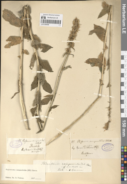
LE 01290344
Groups of specimens: Образцы сектора Средней АзииRecord creation: 2024-08-04, Daria Yudova, PhotoScan D2.Citation: Specimen LE 01290344 // Virtual herbarium of Komarov Botanical Institute RAS — http://re.herbariumle.ru/01290344
LE 01290472
Asyneuma campanuloides (M. Bieb. ex Sims) Bornm. det. Fedorov, Andrey Aleksandrovich at 1954
Collectors: Busch, Elizaveta Aleksandrovna; Busch, Nikolai Adolfovich (Nikolaj Adolfowitsch) Collection date: 20.07.1911. Administrative regions: RU - North Ossetia. Groups of specimens: Образцы сектора Кавказа; Соглашение Минобрнауки №075-15-2021-1056Original label text:Субальпийский луг на Терской. 8000' - 8200'.
Coordinates (geographic position): 43° 43′ 2.26″ N, 44° 42′ 52.87″ EComment: 20.VII.1911
Е. А. и Н. А. Буш
Subalpine meadow on Terskaya. 8000' - 8200'.
Record creation: 2024-08-04, Daria Yudova, PhotoScan D2.Citation: Specimen LE 01290472 // Virtual herbarium of Komarov Botanical Institute RAS — http://re.herbariumle.ru/0129047220.07.1911
Coll. E. Busch, N. Busch
LE 01290343
Groups of specimens: Образцы сектора Средней АзииRecord creation: 2024-08-04, Daria Yudova, PhotoScan D2.Citation: Specimen LE 01290343 // Virtual herbarium of Komarov Botanical Institute RAS — http://re.herbariumle.ru/01290343
LE 01290471
Asyneuma campanuloides (M. Bieb. ex Sims) Bornm. det. Fedorov, Andrey Aleksandrovich at 1954
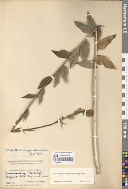
Collectors: Busch, Elizaveta Aleksandrovna; Busch, Nikolai Adolfovich (Nikolaj Adolfowitsch) Collection date: 20.07.1913. Administrative regions: RU - Kabardino-Balkarskaya Respublika. Groups of specimens: Образцы сектора Кавказа; Соглашение Минобрнауки №075-15-2021-1056Original label text:Терская область. Среди Betula raddeana на Башиль-ауз близ верхней границы березы, верховья Чегема. 6500' - 6800'.
Coordinates (geographic position): 43° 12′ 47.52″ N, 43° 0′ 52.08″ EComment: Kabardino-Balkaria.Among Betula raddeana on the Bashil-auz river, near the upper border of the birch, upper reaches of the Chegem river. 6500' - 6800'.
Record creation: 2024-08-04, Daria Yudova, PhotoScan D2.Citation: Specimen LE 01290471 // Virtual herbarium of Komarov Botanical Institute RAS — http://re.herbariumle.ru/0129047120.07.1913
Coll. E. Busch, N. Busch
LE 01290341
Groups of specimens: Образцы сектора Средней АзииRecord creation: 2024-08-04, Daria Yudova, PhotoScan D2.Citation: Specimen LE 01290341 // Virtual herbarium of Komarov Botanical Institute RAS — http://re.herbariumle.ru/01290341
LE 01290470
Asyneuma campanuloides (M. Bieb. ex Sims) Bornm. det. Fedorov, Andrey Aleksandrovich at 1954
Collectors: Busch, Elizaveta Aleksandrovna; Busch, Nikolai Adolfovich (Nikolaj Adolfowitsch) Collection date: 21.07.1930. Subregion: South Ossetia. Expedition: Юго-Осетинская экспедиция АН СССР ()Groups of specimens: Образцы сектора Кавказа; Соглашение Минобрнауки №075-15-2021-1056Original label text:Чапарухское ущелье. Сенокосный субальпийский луг близ Нижнего Чапаруха. 2100 м.
Coordinates (geographic position): 42° 23′ 31.71″ N, 44° 15′ 3.55″ E 2100 m a.s.l.Comment: 21.VII.1930
Е. и Н. Буш
South Ossetia. Chaparukh Gorge. Subalpine meadow near Nizhny Chaparukh. 2100 m.
Record creation: 2024-08-04, Daria Yudova, PhotoScan D2.Citation: Specimen LE 01290470 // Virtual herbarium of Komarov Botanical Institute RAS — http://re.herbariumle.ru/0129047021.07.1930
Coll. E. Busch, N. Busch
LE 01290340
Groups of specimens: Образцы сектора Средней АзииRecord creation: 2024-08-04, Daria Yudova, PhotoScan D2.Citation: Specimen LE 01290340 // Virtual herbarium of Komarov Botanical Institute RAS — http://re.herbariumle.ru/01290340
LE 01290469
Asyneuma campanuloides (M. Bieb. ex Sims) Bornm. det. Fedorov, Andrey Aleksandrovich at 1954
Collectors: Stuckenberg, Elisabeth Karlovna Field collecting number: 64. Collection date: 21.06.1912. Administrative regions: RU - Stavropol'skiy Kray. Groups of specimens: Образцы сектора Кавказа; Соглашение Минобрнауки №075-15-2021-1056Original label text:Терская область. Окрестности Ессентуков. Долина реки Подкумка. Заросли кустарников.
Coordinates (geographic position): 43° 59′ 45.51″ N, 42° 48′ 1.72″ EComment: № 64.
1912.VI.21
E. Штукенберг
Stavropol'skiy Kray, vicinity of the Yessentuki, valley of the Podkumok river.
Record creation: 2024-08-04, Daria Yudova, PhotoScan D2.Citation: Specimen LE 01290469 // Virtual herbarium of Komarov Botanical Institute RAS — http://re.herbariumle.ru/0129046922.07.1912
Coll. E. Stuckenberg
LE 01290339
Groups of specimens: Образцы сектора Средней АзииRecord creation: 2024-08-04, Daria Yudova, PhotoScan D2.Citation: Specimen LE 01290339 // Virtual herbarium of Komarov Botanical Institute RAS — http://re.herbariumle.ru/01290339
LE 01290468
Asyneuma campanuloides (M. Bieb. ex Sims) Bornm. det. Fedorov, Andrey Aleksandrovich at 1954
Collectors: Gomerov, K.E. Collection date: 25.07.1915. Administrative regions: GE - Abkhazia. Groups of specimens: Образцы сектора Кавказа; Соглашение Минобрнауки №075-15-2021-1056Original label text:Село Ажары [= Ажара] Сухумского округа. Гора Большая Футия [= Большая Хутыа]. Нижний луг.
Coordinates (geographic position): 43° 10′ 30.94″ N, 41° 48′ 47.03″ EComment: 25.VII.1915
Гомеров К. Е.
Abkhazia, the Azhara village, the Bolshaya Khutya mount.
Record creation: 2024-08-04, Daria Yudova, PhotoScan D2.Citation: Specimen LE 01290468 // Virtual herbarium of Komarov Botanical Institute RAS — http://re.herbariumle.ru/0129046825.07.1915
Coll. K. E. Gomerov
LE 01290338
Groups of specimens: Образцы сектора Средней АзииRecord creation: 2024-08-04, Daria Yudova, PhotoScan D2.Citation: Specimen LE 01290338 // Virtual herbarium of Komarov Botanical Institute RAS — http://re.herbariumle.ru/01290338
LE 01290467
Asyneuma campanuloides (M. Bieb. ex Sims) Bornm. det. Fedorov, Andrey Aleksandrovich at 1954
Collectors: Grubov, Valery Ivanovich; Ivanina, Lyudmila Ivanovna Collection date: 24.07.1945. Expedition: Кавказская комплексная экспедиция АН СССР (1945 -1946)Groups of specimens: Образцы сектора Кавказа; Соглашение Минобрнауки №075-15-2021-1056Original label text:Северный Кавказ. Бассейн реки Уруп.
Coordinates (geographic position): 1538 m a.s.l.Comment: Скалистый хребет. Граматуха. Вершина 1538. Луг на северном склоне.
24.VIII.1945
В. И. Грубов и Л. И. Иванина
North Caucasus. Basin of the Urup River. Skalisty ridge. Gramatukha. h = 1538 m.
Record creation: 2024-08-04, Daria Yudova, PhotoScan D2.Citation: Specimen LE 01290467 // Virtual herbarium of Komarov Botanical Institute RAS — http://re.herbariumle.ru/0129046724.08.1945
Coll. V. I. Grubov, L. I. Ivanina
LE 01290337
Groups of specimens: Образцы сектора Средней АзииRecord creation: 2024-08-04, Daria Yudova, PhotoScan D2.Citation: Specimen LE 01290337 // Virtual herbarium of Komarov Botanical Institute RAS — http://re.herbariumle.ru/01290337
LE 01290466
Asyneuma campanuloides (M. Bieb. ex Sims) Bornm. det. Fedorov, Andrey Aleksandrovich at 1954
Collectors: Grubov, Valery Ivanovich; Ivanina, Lyudmila Ivanovna Collection date: 23.08.1945. Expedition: Кавказская комплексная экспедиция АН СССР (1945 -1946)Groups of specimens: Образцы сектора Кавказа; Соглашение Минобрнауки №075-15-2021-1056Original label text:Северный Кавказ. Бассейн реки Уруп.
Coordinates (geographic position): 43° 42′ 40.97″ N, 41° 6′ 50.87″ E 2400 m a.s.l.Comment: Передовой хребет. Чилик-скала. Южный склон. Среди камней в западне. 2400 м.
23.VIII.1945
В. И. Грубов и Л. И. Иванина
North Caucasus. Basin of the Urup River. Front Range. Chilik rock. Southern slope. Among the stones in a trap. 2400 m.
Record creation: 2024-08-04, Daria Yudova, PhotoScan D2.Citation: Specimen LE 01290466 // Virtual herbarium of Komarov Botanical Institute RAS — http://re.herbariumle.ru/0129046623.08.1945
Coll. V. I. Grubov, L. I. Ivanina
LE 01290336
Groups of specimens: Образцы сектора Средней АзииRecord creation: 2024-08-04, Daria Yudova, PhotoScan D2.Citation: Specimen LE 01290336 // Virtual herbarium of Komarov Botanical Institute RAS — http://re.herbariumle.ru/01290336
LE 01290465
Asyneuma campanuloides (M. Bieb. ex Sims) Bornm. det. Fedorov, Andrey Aleksandrovich at 1954
Collection date: 29.06.1896. Administrative regions: RU - Stavropol'skiy Kray. Groups of specimens: Образцы сектора Кавказа; Соглашение Минобрнауки №075-15-2021-1056Original label text:96. VI.29 Пятигорск. Вершина Бештау.
Coordinates (geographic position): 44° 5′ 50.92″ N, 43° 1′ 25.63″ EComment: Stavropol'skiy Kray. Pyatigorsk. The Beshtau mount.
Record creation: 2024-08-04, Daria Yudova, PhotoScan D2.Citation: Specimen LE 01290465 // Virtual herbarium of Komarov Botanical Institute RAS — http://re.herbariumle.ru/0129046529.06.1896
LE 01290335
Groups of specimens: Образцы сектора Средней АзииRecord creation: 2024-08-04, Daria Yudova, PhotoScan D2.Citation: Specimen LE 01290335 // Virtual herbarium of Komarov Botanical Institute RAS — http://re.herbariumle.ru/01290335
LE 01290464
Asyneuma campanuloides (M. Bieb. ex Sims) Bornm. det. Fedorov, Andrey Aleksandrovich at 1954
Collectors: Alexeenko, Fyodor Nikitich Collection date: 17.07.1896. Administrative regions: RU - Kabardino-Balkarskaya Respublika. Groups of specimens: Образцы сектора Кавказа; Соглашение Минобрнауки №075-15-2021-1056Original label text:Prov. Terek. Ad fl. Baksan. prope Terskol. 7000'
Coordinates (geographic position): 43° 15′ 22.87″ N, 42° 31′ 16.32″ ERecord creation: 2024-08-04, Daria Yudova, PhotoScan D2.Citation: Specimen LE 01290464 // Virtual herbarium of Komarov Botanical Institute RAS — http://re.herbariumle.ru/0129046417 jul. 96
leg. Th. Alexeenko
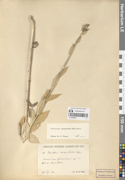
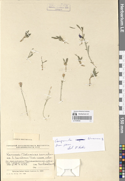
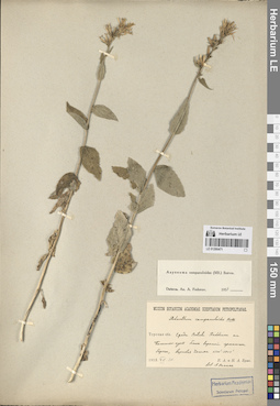
LE 01290334
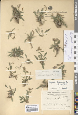
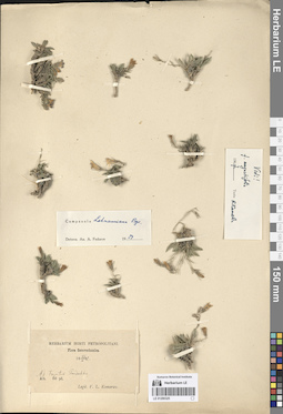
Campanula lehmanniana Bunge det. Kamelin, Rudolph Vladimirovich at 1967
Collectors: Kamelin, Rudolph Vladimirovich Collection date: 07.1965. Administrative regions: TJ - Tajikistan. Groups of specimens: Образцы сектора Средней АзииOriginal label text:Таджикистан, Гиссарский хребет, ущелье реки Варзоб, по скалам в 1 1/2 км к югу от устья Майхуры.
Coordinates (geographic position): 39° 0′ 41.64″ N, 68° 46′ 35.01″ EComment: VII.1965
Р. Камелин
Tajikistan, Gissar Range, Varzob River Gorge, along the rocks 1,5 km south of the mouth of the Maykhura.
Record creation: 2024-08-04, Daria Yudova, PhotoScan D2.Citation: Specimen LE 01290334 // Virtual herbarium of Komarov Botanical Institute RAS — http://re.herbariumle.ru/0129033407.1965
Coll. R. Kamelin
LE 01290463
Asyneuma campanuloides (M. Bieb. ex Sims) Bornm. det. Fedorov, Andrey Aleksandrovich at 1954
Collectors: Stuckenberg, Elisabeth Karlovna Collection date: 22.07.1912. Administrative regions: RU - Stavropol'skiy Kray. Groups of specimens: Образцы сектора Кавказа; Соглашение Минобрнауки №075-15-2021-1056Original label text:Терская область. Окрестности Кисловодска. На Седло-гору, склоны, луга.
Coordinates (geographic position): 43° 53′ 12.96″ N, 42° 47′ 18.1″ EComment: 1912.VII.22
E. Штукенберг
Stavropol'skiy Kray, vicinity of the Kislovodsk, the Sedlo mount.
Record creation: 2024-08-04, Daria Yudova, PhotoScan D2.Citation: Specimen LE 01290463 // Virtual herbarium of Komarov Botanical Institute RAS — http://re.herbariumle.ru/0129046322.07.1912
Coll. E. Stuckenberg
LE 01290333
Groups of specimens: Образцы сектора Средней АзииRecord creation: 2024-08-04, Daria Yudova, PhotoScan D2.Citation: Specimen LE 01290333 // Virtual herbarium of Komarov Botanical Institute RAS — http://re.herbariumle.ru/01290333
LE 01290462
Asyneuma campanuloides (M. Bieb. ex Sims) Bornm. det. Fedorov, Andrey Aleksandrovich at 1954
Collectors: Gordiagin (Gordyagin), Andrei Yakovlevich Collection date: 11.07.1911. Administrative regions: RU - Stavropol'skiy Kray. Groups of specimens: Образцы сектора Кавказа; Соглашение Минобрнауки №075-15-2021-1056; Herbarium universitatis KazanensisOriginal label text:Prov. Terek, distr. Pjatigorsk
Coordinates (geographic position): 43° 50′ 45.13″ N, 42° 51′ 46.29″ EComment: Б. Джинал - Кисловодск, в районе Треугольника.
11.VII.1911
A. Gordiagin
Stavropol'skiy Kray, Kislovodsk, the Dzhinal ridge.
Record creation: 2024-08-04, Daria Yudova, PhotoScan D2.Citation: Specimen LE 01290462 // Virtual herbarium of Komarov Botanical Institute RAS — http://re.herbariumle.ru/0129046211.07.1911
Coll. A. Gordiagin
LE 01290332
Groups of specimens: Образцы сектора Средней АзииRecord creation: 2024-08-04, Daria Yudova, PhotoScan D2.Citation: Specimen LE 01290332 // Virtual herbarium of Komarov Botanical Institute RAS — http://re.herbariumle.ru/01290332
LE 01290461
Asyneuma campanuloides (M. Bieb. ex Sims) Bornm. det. Fedorov, Andrey Aleksandrovich at 1954
Collectors: Alexeenko, Fyodor Nikitich Collection date: 28.06.1897. Administrative regions: RU - Dagestan - Buynakskiy Rayon. Groups of specimens: Образцы сектора Кавказа; Соглашение Минобрнауки №075-15-2021-1056Original label text:Prov. Terek. Distr. Chassaw-jurt, Salatau. Supra p. Honzagoi [= Honzahoi, Хонзахой], in pratis. 5000'.
Coordinates (geographic position): 42° 53′ 3.44″ N, 46° 47′ 58.21″ ERecord creation: 2024-08-04, Daria Yudova, PhotoScan D2.Citation: Specimen LE 01290461 // Virtual herbarium of Komarov Botanical Institute RAS — http://re.herbariumle.ru/0129046128.VI.1897
leg. Th. Alexeenko
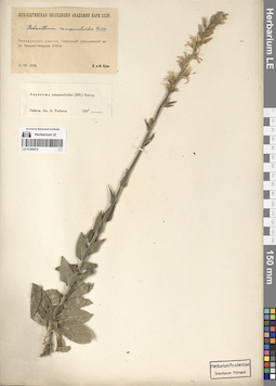
LE 01290460
Asyneuma campanuloides (M. Bieb. ex Sims) Bornm. det. Fedorov, Andrey Aleksandrovich at 1954
Collectors: Alexeenko, Fyodor Nikitich Collection date: 01.08.1898. Administrative regions: RU - Dagestan. Groups of specimens: Образцы сектора Кавказа; Соглашение Минобрнауки №075-15-2021-1056Original label text:Prov. Dagestan. Distr. Samur. Prope pagum Kurusch. In pratis. 7600'.
Coordinates (geographic position): 41° 17′ 14.26″ N, 47° 49′ 59.22″ ERecord creation: 2024-08-04, Daria Yudova, PhotoScan D2.Citation: Specimen LE 01290460 // Virtual herbarium of Komarov Botanical Institute RAS — http://re.herbariumle.ru/012904601 aug. 1898
leg. Th. Alexeenko
LE 01290331
Groups of specimens: Образцы сектора Средней АзииRecord creation: 2024-08-04, Daria Yudova, PhotoScan D2.Citation: Specimen LE 01290331 // Virtual herbarium of Komarov Botanical Institute RAS — http://re.herbariumle.ru/01290331
LE 01290459
Asyneuma campanuloides (M. Bieb. ex Sims) Bornm. det. Goltsova N. N.
Collectors: Goltsova N. N. Collection date: 06.07.1975. Administrative regions: RU - Krasnodarskiy Kray. Groups of specimens: Образцы сектора Кавказа; Соглашение Минобрнауки №075-15-2021-1056Original label text:Западное Закавказье, окрестности поселка Красная поляна, г. Ачишхо.
Coordinates (geographic position): 43° 43′ 25.68″ N, 40° 7′ 45.8″ EComment: 6.VII.1975
Гольцова Н.
Western Transcaucasia, vicinity of the village of Krasnaya Polyana, the Achishkho mount.
Record creation: 2024-08-04, Daria Yudova, PhotoScan D2.Citation: Specimen LE 01290459 // Virtual herbarium of Komarov Botanical Institute RAS — http://re.herbariumle.ru/012904596.07.1975
Coll. N. Goltsova
LE 01290330
Groups of specimens: Образцы сектора Средней АзииRecord creation: 2024-08-04, Daria Yudova, PhotoScan D2.Citation: Specimen LE 01290330 // Virtual herbarium of Komarov Botanical Institute RAS — http://re.herbariumle.ru/01290330
LE 01290458
Asyneuma campanuloides (M. Bieb. ex Sims) Bornm. det. Fedorov, Andrey Aleksandrovich at 1954
Collectors: Becker, Alexander K. Field collecting number: 35. Collection date: 1867. Administrative regions: RU - Stavropol'skiy Kray. Groups of specimens: Образцы сектора Кавказа; Соглашение Минобрнауки №075-15-2021-1056Original label text:Beschtau.
Coordinates (geographic position): 44° 4′ 39.17″ N, 43° 0′ 52.87″ EComment: Leg. Becker 1867.
Stavropol'skiy Kray. Mount Beschtau.
Record creation: 2024-08-04, Daria Yudova, PhotoScan D2.Citation: Specimen LE 01290458 // Virtual herbarium of Komarov Botanical Institute RAS — http://re.herbariumle.ru/01290458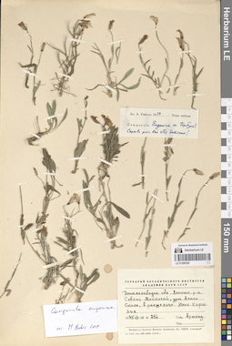
LE 01290329
Groups of specimens: Образцы сектора Средней АзииRecord creation: 2024-08-04, Daria Yudova, PhotoScan D2.Citation: Specimen LE 01290329 // Virtual herbarium of Komarov Botanical Institute RAS — http://re.herbariumle.ru/01290329
LE 01290457
Asyneuma campanuloides (M. Bieb. ex Sims) Bornm. det. Fedorov, Andrey Aleksandrovich at 1954
Collectors: Radde, Gustav Ferdinand Richard Johannes von Field collecting number: 250. Collection date: 29.07.1885. Administrative regions: RU - Dagestan. Groups of specimens: Образцы сектора Кавказа; Соглашение Минобрнауки №075-15-2021-1056Original label text:Leg. G. Radde 29.VII.1885
Coordinates (geographic position): 42° 32′ 42.61″ N, 46° 42′ 53.29″ ERecord creation: 2024-08-04, Daria Yudova, PhotoScan D2.Citation: Specimen LE 01290457 // Virtual herbarium of Komarov Botanical Institute RAS — http://re.herbariumle.ru/01290457Caucasus - Chunsach, 5500 - 6000'.
LE 01290328
Groups of specimens: Образцы сектора Средней АзииRecord creation: 2024-08-04, Daria Yudova, PhotoScan D2.Citation: Specimen LE 01290328 // Virtual herbarium of Komarov Botanical Institute RAS — http://re.herbariumle.ru/01290328
LE 01290456
Asyneuma campanuloides (M. Bieb. ex Sims) Bornm. det. Fedorov, Andrey Aleksandrovich at 1954
Collectors: Massagetov, Pitirim Sergeevich Collection date: 18.07.1903. Administrative regions: GE - Georgia. Groups of specimens: Образцы сектора Кавказа; Соглашение Минобрнауки №075-15-2021-1056Original label text:Бакуриани. ["..."]
18.VII.1903П. С. Массагетов
Georgia, Bakuriani.
Record creation: 2024-08-04, Daria Yudova, PhotoScan D2.Citation: Specimen LE 01290456 // Virtual herbarium of Komarov Botanical Institute RAS — http://re.herbariumle.ru/0129045618.07.1903
Coll. P. S. Massagetov
LE 01290327
Groups of specimens: Образцы сектора Средней АзииRecord creation: 2024-08-04, Daria Yudova, PhotoScan D2.Citation: Specimen LE 01290327 // Virtual herbarium of Komarov Botanical Institute RAS — http://re.herbariumle.ru/01290327
LE 01290455
Asyneuma campanuloides (M. Bieb. ex Sims) Bornm. det. Fedorov, Andrey Aleksandrovich at 1954
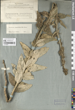
Collectors: Bordzilowski, Eugen Iwanowitsch Collection date: 04.07.1907. Administrative regions: GE - Georgia. Groups of specimens: Образцы сектора Кавказа; Соглашение Минобрнауки №075-15-2021-1056Original label text:Transcaucasia. Armenia Rossica.
Coordinates (geographic position): 41° 25′ 17.31″ N, 43° 34′ 1.54″ ERecord creation: 2024-08-04, Daria Yudova, PhotoScan D2.Citation: Specimen LE 01290455 // Virtual herbarium of Komarov Botanical Institute RAS — http://re.herbariumle.ru/01290455Distr. Akhalkalaki. In prato in decliviis angustiarum Busawetensium in via ex Akhalkalaki versus pagum Busawet [= Buzaveti].
4.VII.1907
Eug. Bordzilowski
LE 01290326
Groups of specimens: Образцы сектора Средней АзииRecord creation: 2024-08-04, Daria Yudova, PhotoScan D2.Citation: Specimen LE 01290326 // Virtual herbarium of Komarov Botanical Institute RAS — http://re.herbariumle.ru/01290326
LE 01290454
Asyneuma campanuloides (M. Bieb. ex Sims) Bornm. det. Fedorov, Andrey Aleksandrovich at 1954
Collectors: Busch, Elizaveta Aleksandrovna Collection date: 24.06.1908. Administrative regions: RU - Karachayevo-Cherkesiya. Groups of specimens: Образцы сектора Кавказа; Соглашение Минобрнауки №075-15-2021-1056Original label text:Prov. Kuban. In sylva frondosa ad ripam sinistram fluminid Teberda. 4200'.
Record creation: 2024-08-04, Daria Yudova, PhotoScan D2.Citation: Specimen LE 01290454 // Virtual herbarium of Komarov Botanical Institute RAS — http://re.herbariumle.ru/0129045424.VI. (7.VII). 1908
Leg. et determ. Elis. Busch
LE 01290325
Groups of specimens: Образцы сектора Средней АзииRecord creation: 2024-08-04, Daria Yudova, PhotoScan D2.Citation: Specimen LE 01290325 // Virtual herbarium of Komarov Botanical Institute RAS — http://re.herbariumle.ru/01290325
LE 01290453
Asyneuma campanuloides (M. Bieb. ex Sims) Bornm. det. Fedorov, Andrey Aleksandrovich at 1954
Field collecting number: 114. Collection date: 1872. Administrative regions: RU - Dagestan. Groups of specimens: Образцы сектора Кавказа; Соглашение Минобрнауки №075-15-2021-1056Original label text:Leg. J. Faust 1872
Coordinates (geographic position): 41° 17′ 26.37″ N, 47° 49′ 24.83″ ERecord creation: 2024-08-04, Daria Yudova, PhotoScan D2.Citation: Specimen LE 01290453 // Virtual herbarium of Komarov Botanical Institute RAS — http://re.herbariumle.ru/01290453Daghestan australis - Kurusch 8 - 12000'.
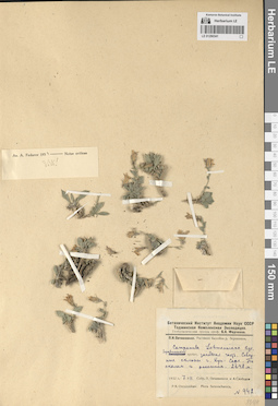
LE 01290324
Groups of specimens: Образцы сектора Средней АзииRecord creation: 2024-08-04, Daria Yudova, PhotoScan D2.Citation: Specimen LE 01290324 // Virtual herbarium of Komarov Botanical Institute RAS — http://re.herbariumle.ru/01290324