View
Add
Copy
Edit
Delete
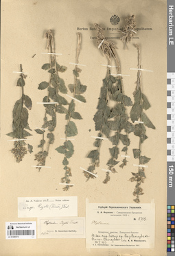
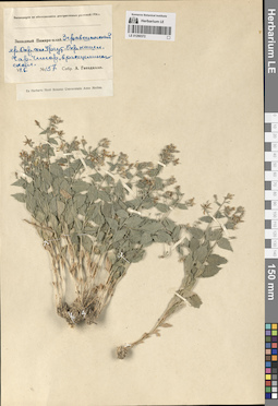
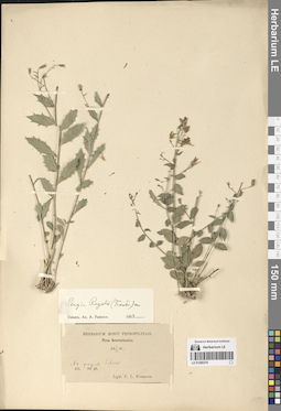
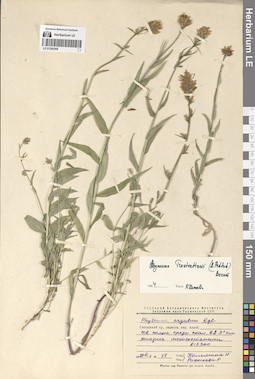
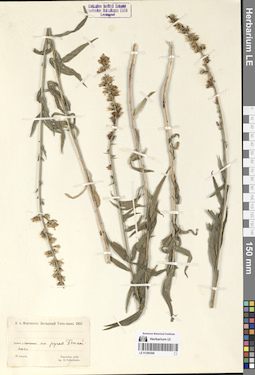
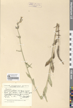
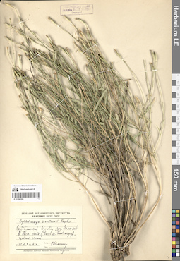
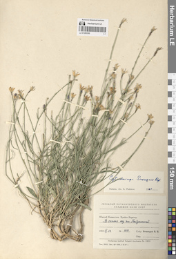
LE 01290374
Sergia regelii (Trautv.) Fed. det. Fedorov, Andrey Aleksandrovich at 1954
Collectors: Michelson, Alexander Ivanovich Field collecting number: 1755. Collection date: 22.05.1913. Administrative regions: UZ - Uzbekistan. Groups of specimens: Образцы сектора Средней АзииOriginal label text:Бухарское ханство, Денауское бекство. Юго-западный отрог Гиссарского хребта. Ущелье реки Сангардак. Нилю х Сангардак.
Coordinates (geographic position): 38° 30′ 39.45″ N, 67° 43′ 17.5″ EComment: 22.V.1913
А. И. Михельсон
№ 1755
Record creation: 2024-08-04, Daria Yudova, PhotoScan D2.Citation: Specimen LE 01290374 // Virtual herbarium of Komarov Botanical Institute RAS — http://re.herbariumle.ru/01290374Bukhara Khanate, Denau Beykdom. Southwestern spur of the Gissar Range. Sangardak River Gorge. Nilu x Sangardak.
22.05.1913
Coll. A. I. Michelson
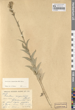
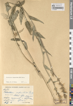
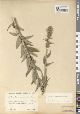
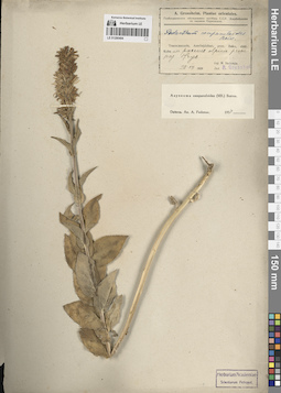
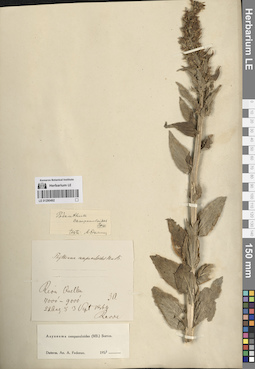
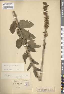
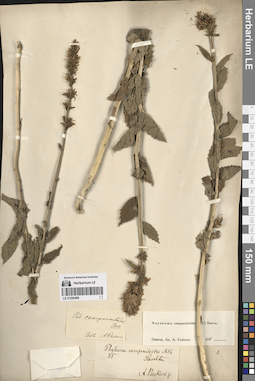
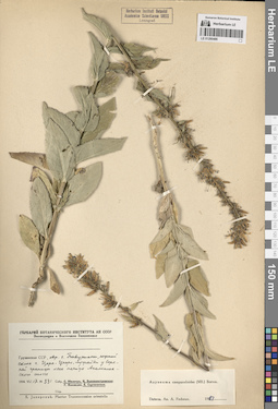
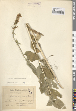
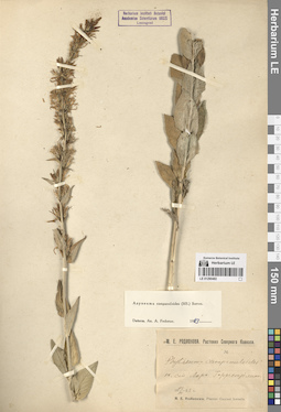
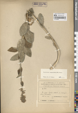
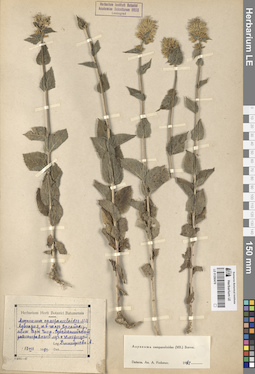
LE 01290502
Asyneuma campanuloides (M. Bieb. ex Sims) Bornm. det. Fedorov, Andrey Aleksandrovich at 1954
Collectors: Busch, Elizaveta Aleksandrovna; Busch, Nikolai Adolfovich (Nikolaj Adolfowitsch) Field collecting number: 67. Collection date: 20.08.1927. Administrative regions: RU - North Ossetia. Groups of specimens: Образцы сектора Кавказа; Соглашение Минобрнауки №075-15-2021-1056Original label text:Дигория. Чефанзар [= Чефандзар]. Субальпийский луг на левом борте ущелья реки Уруха, склон над болотом. 2300 м.
Coordinates (geographic position): 42° 55′ 23.06″ N, 43° 30′ 25.98″ E 2300 m a.s.l.Comment: 20.VIII.1927
Е. и Н. Буш
Digoria. Chefanzar [= Chefandzar]. Subalpine meadow on the left side of the Urukh River gorge, slope above the swamp. 2300 m.
Record creation: 2024-08-04, Daria Yudova, PhotoScan D2.Citation: Specimen LE 01290502 // Virtual herbarium of Komarov Botanical Institute RAS — http://re.herbariumle.ru/0129050220.08.1927
Coll. E. Busch, N. Busch
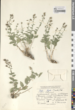
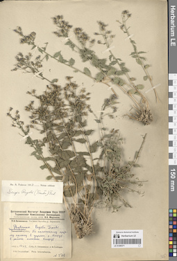
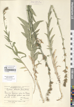
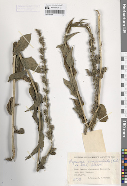
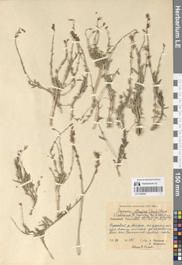
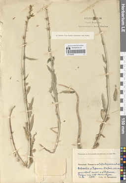
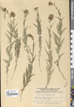
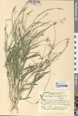
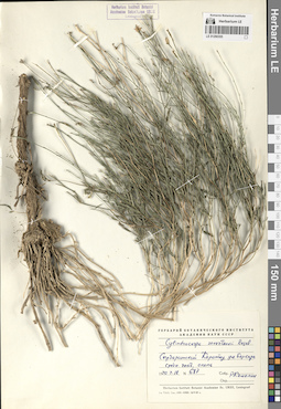
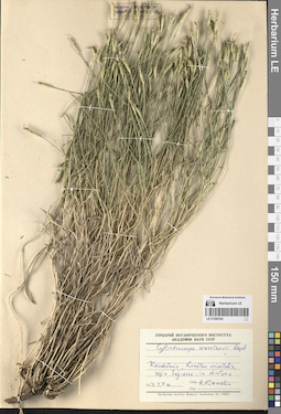
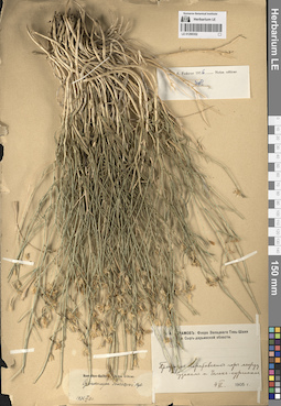
LE 01290373
Sergia regelii (Trautv.) Fed. det. Kamelin, Rudolph Vladimirovich
Collectors: Strizhova, Tamara Georgievna Field collecting number: 737. Collection date: 27.06.1961. Administrative regions: TJ - Viloyati Sughd. Groups of specimens: Образцы сектора Средней АзииOriginal label text:Таджикистан. Северный Зеравшанский хребет, правобережье реки Кштут, между кишлаками Кульяли и Шишкат. На щебнистом восточном склоне; h - 1450 м.
Coordinates (geographic position): 39° 22′ 42.14″ N, 68° 2′ 59.7″ EComment: № 737
27 июня 1961
Т. Стрижова
Tajikistan. Northern Zeravshan Range, right bank of the Kshtut River, between the villages of Kulyali and Shishkat. On the gravelly eastern slope; h - 1450 m.
Record creation: 2024-08-04, Daria Yudova, PhotoScan D2.Citation: Specimen LE 01290373 // Virtual herbarium of Komarov Botanical Institute RAS — http://re.herbariumle.ru/01290373№ 737
27.06.1961
Coll. T. Strizhova
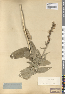
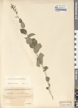
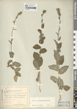
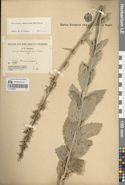
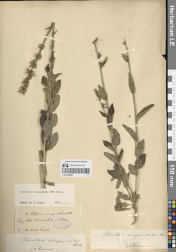
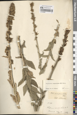
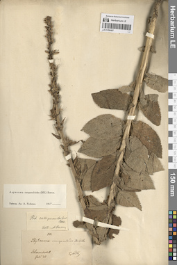
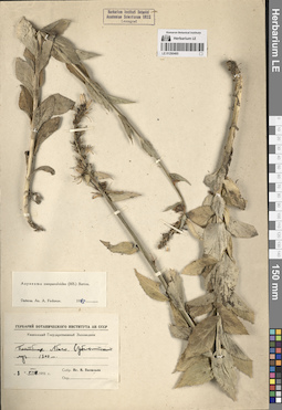
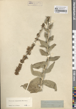
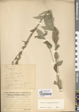
LE 01290501
Asyneuma campanuloides (M. Bieb. ex Sims) Bornm. det. Fedorov, Andrey Aleksandrovich at 1954
Collection date: 03.07.1896. Administrative regions: RU - Stavropol'skiy Kray. Groups of specimens: Образцы сектора Кавказа; Соглашение Минобрнауки №075-15-2021-1056Original label text:Пятигорск.
Coordinates (geographic position): 44° 3′ 48.87″ N, 43° 1′ 15.7″ EComment: 3.VII.96
Stavropol'skiy Kray. Pyatigorsk.
Record creation: 2024-08-04, Daria Yudova, PhotoScan D2.Citation: Specimen LE 01290501 // Virtual herbarium of Komarov Botanical Institute RAS — http://re.herbariumle.ru/0129050103.07.1896
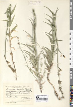
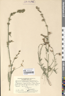
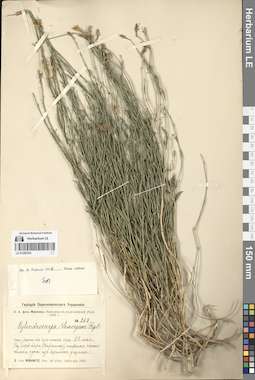
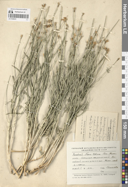
LE 01290372
Sergia regelii (Trautv.) Fed.
Collectors: Gnezdillo A. Field collecting number: 157. Collection date: 06.06. Administrative regions: UZ - Uzbekistan. Groups of specimens: Образцы сектора Средней АзииOriginal label text:Западный Памиро-алай. Зеравшанский хребет. Окрестности села Ургут. Окрестности кишлака Чар-Чинар, в расщелинах скал.
Coordinates (geographic position): 39° 23′ 11.05″ N, 67° 16′ 32.89″ EComment: 6.VI.
№ 157
А. Гнездилло
Western Pamir-Alai. Zeravshan Range. The outskirts of the Urgut village. The outskirts of the Char-Chinar village, in the crevices of the rocks.
6.06.
Coll. A. Gnezdillo
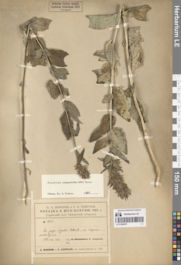
LE 01290500
Asyneuma campanuloides (M. Bieb. ex Sims) Bornm. det. Fedorov, Andrey Aleksandrovich at 1954
Collectors: Busch, Elizaveta Aleksandrovna; Busch, Nikolai Adolfovich (Nikolaj Adolfowitsch) Field collecting number: 43. Collection date: 19.07.1927. Administrative regions: RU - Kabardino-Balkarskaya Respublika. Groups of specimens: Образцы сектора Кавказа; Соглашение Минобрнауки №075-15-2021-1056Original label text:Балкария, Дых-су. Левый борт ущелья между [караулкой] и охотничьим мостиком. 1700 м.
Coordinates (geographic position): 42° 58′ 50.08″ N, 43° 17′ 18.74″ E 1700 m a.s.l.Comment: 19.VII.1927
Е. и Н. Буш
Balkaria, the Dykhsu river. Left side of the gorge. 1700 m.
Record creation: 2024-08-04, Daria Yudova, PhotoScan D2.Citation: Specimen LE 01290500 // Virtual herbarium of Komarov Botanical Institute RAS — http://re.herbariumle.ru/0129050019.07.1927
Coll. E. Busch, N. Busch
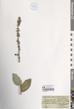
LE 01290371
Sergia regelii (Trautv.) Fed. det. Fedorov, Andrey Aleksandrovich at 1954
Collectors: Ovczinnikov, Pavel Nikolaevich; Slobodov, A.A. Field collecting number: 576. Collection date: 14.06.1932. Administrative regions: TJ - Viloyati Sughd. Groups of specimens: Образцы сектора Средней АзииOriginal label text:Зеравшанский хребет. По каменистому крутому склону в ущелье реки Кштут в районе кишлака Кштут.
Coordinates (geographic position): 39° 21′ 23.66″ N, 68° 2′ 51.35″ EComment: 14.VI.1932
П. Овчинников, А. Слободов
Zeravshan Range. Along the rocky steep slope in the gorge of the Kshtut River in the area of the Kshtut village.
Record creation: 2024-08-04, Daria Yudova, PhotoScan D2.Citation: Specimen LE 01290371 // Virtual herbarium of Komarov Botanical Institute RAS — http://re.herbariumle.ru/0129037114.06.1932
Coll. P. Ovczinnikov, A. Slobodov
LE 01290499
Asyneuma campanuloides (M. Bieb. ex Sims) Bornm. det. Fedorov, Andrey Aleksandrovich at 1954
Collectors: Busch, Elizaveta Aleksandrovna; Busch, Nikolai Adolfovich (Nikolaj Adolfowitsch) Collection date: 08.08.1930. Subregion: South Ossetia. Expedition: Юго-Осетинская экспедиция АН СССР ()Groups of specimens: Образцы сектора Кавказа; Соглашение Минобрнауки №075-15-2021-1056Original label text:Верховья Куптинского ущелья. Субальпийский луг на урочище Купта-угардан. 2100 м.
Comment: 8.VIII.1930
Е. и Н. Буш
Upper reaches of Kuptinsky gorge. Subalpine meadow in Kupta-ugardan. 2100 m.
Record creation: 2024-08-04, Daria Yudova, PhotoScan D2.Citation: Specimen LE 01290499 // Virtual herbarium of Komarov Botanical Institute RAS — http://re.herbariumle.ru/012904998.08.1930
Coll. E. Busch, N. Busch
LE 01290370
Sergia regelii (Trautv.) Fed. det. Fedorov, Andrey Aleksandrovich at 1954
Collectors: Komarov, Vladimir Leontjevich Collection date: 30.05.1892. Administrative regions: TJ - Viloyati Sughd. Groups of specimens: Образцы сектора Средней АзииOriginal label text:Flora Seravschanica
Coordinates (geographic position): 39° 16′ 24.59″ N, 67° 49′ 7.1″ ERecord creation: 2024-08-04, Daria Yudova, PhotoScan D2.Citation: Specimen LE 01290370 // Virtual herbarium of Komarov Botanical Institute RAS — http://re.herbariumle.ru/01290370Ad pagum Schink.
30.V.1892
V. L. Komarov
LE 01290498
Asyneuma campanuloides (M. Bieb. ex Sims) Bornm. det. Fedorov, Andrey Aleksandrovich at 1954
Collectors: Busch, Elizaveta Aleksandrovna; Busch, Nikolai Adolfovich (Nikolaj Adolfowitsch) Field collecting number: 42. Collection date: 14.08.1925. Administrative regions: RU - North Ossetia. Groups of specimens: Образцы сектора Кавказа; Соглашение Минобрнауки №075-15-2021-1056Original label text:Дигория. Субальпийский луг на [...] у нижнего конца Чефанзара. 2400 м.
Coordinates (geographic position): 42° 55′ 13.52″ N, 43° 30′ 32.12″ E 2400 m a.s.l.Comment: 14.VIII.1925
Е. и Н. Буш
Digoria. Chefanzar [= Chefandzar]. 2400 m.
14.08.1925Coll. E. Busch, N. Busch
LE 01290369
Groups of specimens: Образцы сектора Средней АзииRecord creation: 2024-08-04, Daria Yudova, PhotoScan D2.Citation: Specimen LE 01290369 // Virtual herbarium of Komarov Botanical Institute RAS — http://re.herbariumle.ru/01290369
LE 01290497
Asyneuma campanuloides (M. Bieb. ex Sims) Bornm. det. Fedorov, Andrey Aleksandrovich at 1954
Collectors: Marcowicz, Vasilii Vasilevicz Collection date: 03.07.1899. Administrative regions: RU - North Ossetia. Groups of specimens: Образцы сектора Кавказа; Соглашение Минобрнауки №075-15-2021-1056Original label text:Кавказ, Осетия, Владикавказский округ, Терская область. Горные луга.
Comment: 3.VII.99
В. В. Маркович
Caucasus, Ossetia, Vladikavkaz district.
03.07.1899
Coll. V. V. Marcowicz
LE 01290368
Groups of specimens: Образцы сектора Средней АзииRecord creation: 2024-08-04, Daria Yudova, PhotoScan D2.Citation: Specimen LE 01290368 // Virtual herbarium of Komarov Botanical Institute RAS — http://re.herbariumle.ru/01290368
LE 01290496
Asyneuma campanuloides (M. Bieb. ex Sims) Bornm.
Collectors: Menitsky, Yuri Leonardovich; Popova, Tamara Nikitichna Field collecting number: 59. Collection date: 23.07.1996. Administrative regions: RU - Kabardino-Balkarskaya Respublika. Groups of specimens: Образцы сектора Кавказа; Соглашение Минобрнауки №075-15-2021-1056Original label text:Северный Кавказ, Кабардино-Балкария, окрестности села Безенги.
Coordinates (geographic position): 43° 12′ 55.44″ N, 43° 16′ 49.3″ EComment: 23.07.1996
Ю. Меницкий, Т. Попова
Northern Caucasus, Kabardino-Balkaria, vicinity of the village of Bezengi.
Record creation: 2024-08-04, Daria Yudova, PhotoScan D2.Citation: Specimen LE 01290496 // Virtual herbarium of Komarov Botanical Institute RAS — http://re.herbariumle.ru/0129049623.07.1996
Coll. Yu. Menitsky, T. Popova
LE 01290367
Groups of specimens: Образцы сектора Средней АзииRecord creation: 2024-08-04, Daria Yudova, PhotoScan D2.Citation: Specimen LE 01290367 // Virtual herbarium of Komarov Botanical Institute RAS — http://re.herbariumle.ru/01290367
LE 01290495
Asyneuma campanuloides (M. Bieb. ex Sims) Bornm. det. Konechnaya, Galina Yurievna
Collectors: Konechnaya, Galina Yurievna; Haare, Ado Oskarovich Collection date: 19.08.1990. Administrative regions: GE - Abkhazia. Groups of specimens: Образцы сектора Кавказа; Соглашение Минобрнауки №075-15-2021-1056Original label text:Абхазская АССР, Кодорское ущелье, правый борт, хр. Хутиа 4 км на С от моста в с. Генцвиши; субальп., ю. склон, 2200 м н.у.м.
Coordinates (geographic position): 43° 6′ 38.98″ N, 41° 48′ 3.4″ E 2200 m a.s.l.Comment: 19.VIII.1990
Г. Ю. Конечная, А. О. Хааре
Abkhazia, right side of the Kodori Gorge, Khutia ridge 4 km to the north from the bridge in the village Gentsvishi; subalps, south slope, 2200 m above sea level.
Record creation: 2024-08-04, Daria Yudova, PhotoScan D2.Citation: Specimen LE 01290495 // Virtual herbarium of Komarov Botanical Institute RAS — http://re.herbariumle.ru/0129049519.08.1990
Coll. G. Yu. Konechnaya, A. O. Haare
LE 01290366
Groups of specimens: Образцы сектора Средней АзииRecord creation: 2024-08-04, Daria Yudova, PhotoScan D2.Citation: Specimen LE 01290366 // Virtual herbarium of Komarov Botanical Institute RAS — http://re.herbariumle.ru/01290366
LE 01290494
Asyneuma campanuloides (M. Bieb. ex Sims) Bornm. det. Fedorov, Andrey Aleksandrovich at 1954
Collectors: Sachokia, Michail Fedorovich Collection date: 28.07.1929. Administrative regions: AZ - Azerbaijan. Expedition: Геоботаническое обследование пастбищ ССР Азербайджана по заданию Наркомзема (1929)Groups of specimens: Образцы сектора Кавказа; Соглашение Минобрнауки №075-15-2021-1056Original label text:Transcaucasia, Azerbajdzhan, prov. Baku, distr. Kuba. In pascuis alpinis prope pag. Kryz [= Грыз, Гырыз].
Coordinates (geographic position): 41° 12′ 39.41″ N, 48° 14′ 33.67″ EComment: 28.VII.1929
M. Sachokjia
Azerbajdzhan, the Gryz village.
Record creation: 2024-08-04, Daria Yudova, PhotoScan D2.Citation: Specimen LE 01290494 // Virtual herbarium of Komarov Botanical Institute RAS — http://re.herbariumle.ru/0129049428.07.1929
Coll. M. Sachokia
LE 01290365
Groups of specimens: Образцы сектора Средней АзииRecord creation: 2024-08-04, Daria Yudova, PhotoScan D2.Citation: Specimen LE 01290365 // Virtual herbarium of Komarov Botanical Institute RAS — http://re.herbariumle.ru/01290365
LE 01290493
Asyneuma campanuloides (M. Bieb. ex Sims) Bornm. det. Fedorov, Andrey Aleksandrovich at 1954
Collectors: Palibin, Ivan Vladimirovich Field collecting number: 1971. Collection date: 08.08.1912. Administrative regions: GE - Abkhazia. Groups of specimens: Образцы сектора Кавказа; Соглашение Минобрнауки №075-15-2021-1056Original label text:№ 1971
Coordinates (geographic position): 43° 27′ 49.5″ N, 40° 29′ 26.36″ EComment: Гора Пшигишха [= Пшегишхва].
Бассейн Бзыби.
8.VIII.1912
И. В. Палибин
Abkhazia. Mount Pshigishkha [= Pshegishkhva]. Basin of the Bzyb River.
Record creation: 2024-08-04, Daria Yudova, PhotoScan D2.Citation: Specimen LE 01290493 // Virtual herbarium of Komarov Botanical Institute RAS — http://re.herbariumle.ru/012904938.08.1912
Coll. I. V. Palibin
LE 01290364
Groups of specimens: Образцы сектора Средней АзииRecord creation: 2024-08-04, Daria Yudova, PhotoScan D2.Citation: Specimen LE 01290364 // Virtual herbarium of Komarov Botanical Institute RAS — http://re.herbariumle.ru/01290364
LE 01290492
Asyneuma campanuloides (M. Bieb. ex Sims) Bornm. det. Fedorov, Andrey Aleksandrovich at 1954
Collectors: Radde, Gustav Ferdinand Richard Johannes von Administrative regions: GE - Georgia. Groups of specimens: Образцы сектора Кавказа; Соглашение Минобрнауки №075-15-2021-1056Original label text:30.
Coordinates (geographic position): 42° 52′ 27.36″ N, 43° 20′ 12.28″ EComment: Rion Quellen
7000' - 9000'
22 Aug. - 3 Sept. 1864
Radde
Georgia. The Rioni river.
Record creation: 2024-08-04, Daria Yudova, PhotoScan D2.Citation: Specimen LE 01290492 // Virtual herbarium of Komarov Botanical Institute RAS — http://re.herbariumle.ru/012904927000' - 9000'
22.08 - 3.09 1864
Coll. Radde
LE 01290363
Groups of specimens: Образцы сектора Средней АзииRecord creation: 2024-08-04, Daria Yudova, PhotoScan D2.Citation: Specimen LE 01290363 // Virtual herbarium of Komarov Botanical Institute RAS — http://re.herbariumle.ru/01290363
LE 01290491
Asyneuma campanuloides (M. Bieb. ex Sims) Bornm. det. Fedorov, Andrey Aleksandrovich at 1954
Collectors: Smirnow, Mikhail Nikolaevich Collection date: 1879. Groups of specimens: Образцы сектора Кавказа; Соглашение Минобрнауки №075-15-2021-1056Original label text:In monte [...] Caucasis
Record creation: 2024-08-04, Daria Yudova, PhotoScan D2.Citation: Specimen LE 01290491 // Virtual herbarium of Komarov Botanical Institute RAS — http://re.herbariumle.ru/01290491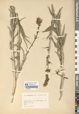
LE 01290362
Groups of specimens: Образцы сектора Средней АзииRecord creation: 2024-08-04, Daria Yudova, PhotoScan D2.Citation: Specimen LE 01290362 // Virtual herbarium of Komarov Botanical Institute RAS — http://re.herbariumle.ru/01290362
LE 01290490
Asyneuma campanuloides (M. Bieb. ex Sims) Bornm. det. Fedorov, Andrey Aleksandrovich at 1954
Collectors: Hoefft (Höfft), F.A. [Haefft] Groups of specimens: Образцы сектора Кавказа; Соглашение Минобрнауки №075-15-2021-1056Original label text:Ded. Dr. Hoefft 1838
Record creation: 2024-08-04, Daria Yudova, PhotoScan D2.Citation: Specimen LE 01290490 // Virtual herbarium of Komarov Botanical Institute RAS — http://re.herbariumle.ru/01290490Caucasus
LE 01290361
Groups of specimens: Образцы сектора Средней АзииRecord creation: 2024-08-04, Daria Yudova, PhotoScan D2.Citation: Specimen LE 01290361 // Virtual herbarium of Komarov Botanical Institute RAS — http://re.herbariumle.ru/01290361
LE 01290489
Asyneuma campanuloides (M. Bieb. ex Sims) Bornm. det. Fedorov, Andrey Aleksandrovich at 1954
Field collecting number: 250. Collection date: 29.07.1885. Groups of specimens: Образцы сектора Кавказа; Соглашение Минобрнауки №075-15-2021-1056Record creation: 2024-08-04, Daria Yudova, PhotoScan D2.Citation: Specimen LE 01290489 // Virtual herbarium of Komarov Botanical Institute RAS — http://re.herbariumle.ru/01290489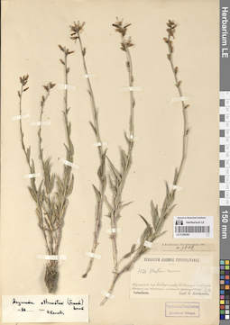
LE 01290360
Groups of specimens: Образцы сектора Средней АзииRecord creation: 2024-08-04, Daria Yudova, PhotoScan D2.Citation: Specimen LE 01290360 // Virtual herbarium of Komarov Botanical Institute RAS — http://re.herbariumle.ru/01290360
LE 01290488
Asyneuma campanuloides (M. Bieb. ex Sims) Bornm. det. Fedorov, Andrey Aleksandrovich at 1954
Collectors: Becker, Alexander K. Field collecting number: 35. Collection date: 1867. Administrative regions: RU - Stavropol'skiy Kray. Groups of specimens: Образцы сектора Кавказа; Соглашение Минобрнауки №075-15-2021-1056Original label text:35
Coordinates (geographic position): 44° 4′ 43.73″ N, 43° 0′ 53.96″ EComment: Beschtau
A. Becker 67
Stavropol'skiy Kray, the Beschtau mount.
Record creation: 2024-08-04, Daria Yudova, PhotoScan D2.Citation: Specimen LE 01290488 // Virtual herbarium of Komarov Botanical Institute RAS — http://re.herbariumle.ru/012904881867
Coll. A. Becker
LE 01290359
Additional identifications: Asyneuma attenuatum (Franch.) Bornm. det. Kamelin, Rudolph Vladimirovich; Asyneuma canescens (Waldst. & Kit.) Griseb. & Schenk Field collecting number: 564. Collection date: 01.08.1970. Groups of specimens: Образцы сектора Средней АзииOriginal label text:
Бадахшан, Андероб, долина Гарм-Чашма (левый берег) в 1 км над источником Гарм-Чашма. На поле. H = 2750 м.
Record creation: 2024-08-04, Daria Yudova, PhotoScan D2.Citation: Specimen LE 01290359 // Virtual herbarium of Komarov Botanical Institute RAS — http://re.herbariumle.ru/01290359№ 564
1.VIII.1970
Султанов С.
LE 01290487
Asyneuma campanuloides (M. Bieb. ex Sims) Bornm. det. Fedorov, Andrey Aleksandrovich at 1954
Field collecting number: 50. Collection date: 07.1875. Groups of specimens: Образцы сектора Кавказа; Соглашение Минобрнауки №075-15-2021-1056Record creation: 2024-08-04, Daria Yudova, PhotoScan D2.Citation: Specimen LE 01290487 // Virtual herbarium of Komarov Botanical Institute RAS — http://re.herbariumle.ru/01290487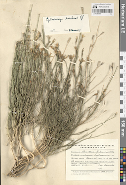
LE 01290358
Cylindrocarpa sewerzowii (Regel) Regel det. Kamelin, Rudolph Vladimirovich at 1964
Collectors: Pjataeva, A. D. Field collecting number: 12. Collection date: 17.06.1959. Administrative regions: KZ - South Kazakhstan - Tuerkistan Qalasy. Groups of specimens: Образцы сектора Средней АзииOriginal label text:Западный Тянь-Шань. По дороге между Орловкой и рудником Байджансаем, по долине реки Каттабугунь [Улькен-бугунь] и её западному притоку. На южном каменисто-щебенчатом склоне (дальше по долине).
Coordinates (geographic position): 43° 5′ 26.88″ N, 69° 55′ 9.27″ EComment: №12
17.VI.1959
Пятаева
Western Tien Shan. Along the road between Orlovka and the Baidzhansai mine, along the Kattabugun [= Ulken-Bugun] River valley and its western tributary. On the southern rocky-gravelly slope (further along the valley).
Record creation: 2024-08-04, Daria Yudova, PhotoScan D2.Citation: Specimen LE 01290358 // Virtual herbarium of Komarov Botanical Institute RAS — http://re.herbariumle.ru/01290358№12
17.06.1959
Coll. Pjataeva
LE 01290486
Asyneuma campanuloides (M. Bieb. ex Sims) Bornm. det. Fedorov, Andrey Aleksandrovich at 1963
Collectors: Juzepczuk, Sergei Vasilievich; Vysokoostrovskaja, I. B.; Sergievskaja, Yekaterina Vladimirovna Field collecting number: 331. Collection date: 17.07.1954. Administrative regions: GE - Georgia. Groups of specimens: Образцы сектора Кавказа; Соглашение Минобрнауки №075-15-2021-1056Original label text:Грузинская ССР, окрестности города Бакуриани, южный склон горы Цхра-Цхаро, лужайки у верхней границы леса пониже Ахалкалакского шоссе.
Coordinates (geographic position): 41° 41′ 43.98″ N, 43° 30′ 42.24″ EComment: № 331
17.VII.1954
С. Юзепчук, И. Высокоостровская, Е. Сергиевская
Georgia, the vicinity of the city of Bakuriani, the southern slope of Mount Tskhra-Tskharo, lawns at the upper border of the forest below the Akhalkalaki highway.№ 331
Record creation: 2024-08-04, Daria Yudova, PhotoScan D2.Citation: Specimen LE 01290486 // Virtual herbarium of Komarov Botanical Institute RAS — http://re.herbariumle.ru/0129048617.07.1954
Coll. S. Juzepczuk, I. Vysokoostrovskaja, E. Sergievskaja
LE 01290357
Cylindrocarpa sewerzowii (Regel) Regel det. Kamelin, Rudolph Vladimirovich
Collectors: Kamelin, Rudolph Vladimirovich Field collecting number: 1554. Collection date: 06.07.1974. Administrative regions: KZ - Kazakhstan. Groups of specimens: Образцы сектора Средней АзииOriginal label text:Казахстан, Сырдарьинский Каратау, центр, массив Мынджилке, ущелье Райс, скалы в выемке с Dryopteris.
Coordinates (geographic position): 43° 47′ 6.64″ N, 68° 42′ 41.74″ EComment: № 1554
6.VII.1974
Р. Камелин
Kazakhstan, The Syrdariyinskiy Karatau Range, the Central Karatau Mountains, Myndzhilke, Rays gorge, rocks in a depression with Dryopteris.
Record creation: 2024-08-04, Daria Yudova, PhotoScan D2.Citation: Specimen LE 01290357 // Virtual herbarium of Komarov Botanical Institute RAS — http://re.herbariumle.ru/01290357№ 1554
06.07.1974
Coll. R. Kamelin
LE 01290485
Asyneuma campanuloides (M. Bieb. ex Sims) Bornm. det. Fedorov, Andrey Aleksandrovich at 1963
Collectors: Vassiljev, Igor V. Collection date: 08.07.1951. Administrative regions: RU - Respublika Adygeya. Groups of specimens: Образцы сектора Кавказа; Соглашение Минобрнауки №075-15-2021-1056Original label text:Пастбище Абаго. Субальпийский луг. 1800 м.
Coordinates (geographic position): 44° 30′ 51.84″ N, 40° 15′ 33.12″ E 1800 m a.s.l.Comment: 8.VII.1951
Иг. В. Васильев
Adygeya, Abago pasture. Subalpine meadow. 1800 m.
8.07.1951
Сoll. Ig. V. Vassiljev
LE 01290356
Cylindrocarpa sewerzowii (Regel) Regel det. Kamelin, Rudolph Vladimirovich
Collectors: Kamelin, Rudolph Vladimirovich Field collecting number: 5-a. Collection date: 04.07.1973. Administrative regions: KZ - Kazakhstan. Groups of specimens: Образцы сектора Средней АзииOriginal label text:Сырдарьинский Каратау, ущелье Алма-сай в восточной части (бассейн озера Бийликуль), щебнистые скалы.
4.07.1973Р. Камелин
Syr Darya Karatau, Alma-sai gorge in the eastern part (Biylikul Lake basin), rubble rocks.
Record creation: 2024-08-04, Daria Yudova, PhotoScan D2.Citation: Specimen LE 01290356 // Virtual herbarium of Komarov Botanical Institute RAS — http://re.herbariumle.ru/012903564.07.1973
Coll. R. Kamelin
LE 01290484
Asyneuma campanuloides (M. Bieb. ex Sims) Bornm. det. Fedorov, Andrey Aleksandrovich at 1963
Collectors: Schelkownikow, Alexandr Bebutovicz; Kara-Murza, Evelina Nikitichna Collection date: 13.07.1927. Administrative regions: AM - Armenia. Groups of specimens: Образцы сектора Кавказа; Соглашение Минобрнауки №075-15-2021-1056Original label text:Лес в верховьях реки Марса-чай [= Тарса-чай, Гетик], за Чубухлинским перевалом.
Coordinates (geographic position): 40° 40′ 11.94″ N, 45° 14′ 45.91″ EComment: 13.VII.1927
A. Schelkovnikov et E. Kara-Murza
Armenia. Forest in the upper reaches of the Tarsa-chay [= Getik] river, beyond the Chubukhlinsky pass.
Record creation: 2024-08-04, Daria Yudova, PhotoScan D2.Citation: Specimen LE 01290484 // Virtual herbarium of Komarov Botanical Institute RAS — http://re.herbariumle.ru/0129048413.07.1927
Coll. A. Schelkovnikov, E. Kara-Murza
LE 01290355
Cylindrocarpa sewerzowii (Regel) Regel det. Kamelin, Rudolph Vladimirovich
Collectors: Kamelin, Rudolph Vladimirovich Field collecting number: 687. Collection date: 18.07.1970. Administrative regions: KZ - Zhambyl Oblysy. Groups of specimens: Образцы сектора Средней АзииOriginal label text:Сырдарьинский Каратау, ущелье Беркара, средняя часть, осыпь.
Coordinates (geographic position): 42° 54′ 11.64″ N, 70° 37′ 6.11″ EComment: № 687
18.07.1970
Р. Камелин
Syr Darya Karatau, Berkara gorge, middle part, scree.
Record creation: 2024-08-04, Daria Yudova, PhotoScan D2.Citation: Specimen LE 01290355 // Virtual herbarium of Komarov Botanical Institute RAS — http://re.herbariumle.ru/01290355№ 687
18.07.1970
Coll. R. Kamelin
LE 01290483
Asyneuma campanuloides (M. Bieb. ex Sims) Bornm. det. Fedorov, Andrey Aleksandrovich at 1963
Collection date: 03.07.1896. Administrative regions: RU - Stavropol'skiy Kray. Groups of specimens: Образцы сектора Кавказа; Соглашение Минобрнауки №075-15-2021-1056Original label text:96.VII.3 Пятигорск.
Coordinates (geographic position): 44° 4′ 18.06″ N, 43° 3′ 20.24″ EComment: Stavropol'skiy Kray, Pyatigorsk.
Record creation: 2024-08-04, Daria Yudova, PhotoScan D2.Citation: Specimen LE 01290483 // Virtual herbarium of Komarov Botanical Institute RAS — http://re.herbariumle.ru/0129048303.07.1896
LE 01290354
Cylindrocarpa sewerzowii (Regel) Regel det. Kamelin, Rudolph Vladimirovich
Collectors: Kamelin, Rudolph Vladimirovich Collection date: 07.07.1971. Administrative regions: KZ - Kazakhstan. Groups of specimens: Образцы сектора Средней АзииOriginal label text:Kasachstania, Karatau orientalis, regio Saj-assu, in shistosis.
Record creation: 2024-08-04, Daria Yudova, PhotoScan D2.Citation: Specimen LE 01290354 // Virtual herbarium of Komarov Botanical Institute RAS — http://re.herbariumle.ru/012903547.07.1971
R. Kamelin
LE 01290482
Asyneuma campanuloides (M. Bieb. ex Sims) Bornm. det. Fedorov, Andrey Aleksandrovich at 1963
Collectors: Rodionova, M. E. Collection date: 27.07.1923. Administrative regions: RU - North Ossetia. Groups of specimens: Образцы сектора Кавказа; Соглашение Минобрнауки №075-15-2021-1056Original label text:Окрестности станции Ларс. Горреспублика.
Coordinates (geographic position): 42° 46′ 12.29″ N, 44° 37′ 46.34″ EComment: 27.VII.1923
М. Е. Родионова
North Ossetia, Verkhniy Lars.
Record creation: 2024-08-04, Daria Yudova, PhotoScan D2.Citation: Specimen LE 01290482 // Virtual herbarium of Komarov Botanical Institute RAS — http://re.herbariumle.ru/0129048227.07.1923
Coll. M. E. Rodionova
LE 01290353
Cylindrocarpa sewerzowii (Regel) Regel
Collectors: Minkwitz, Zinaida Alexandrovna Field collecting number: 268. Collection date: 23.05.1909. Administrative regions: KZ - Zhambyl Oblysy. Groups of specimens: Образцы сектора Средней АзииOriginal label text:Сыр-Дарьинская область. Аулие-атинский уезд. Ущелье Берк-кара (Каратау), нижняя часть склона одной из вершин ущелья.
Coordinates (geographic position): 42° 54′ 53.59″ N, 70° 37′ 16.14″ EComment: 23 мая 1909 г.
З. А. фон Минквиц
Syr Darya region. Aulie-Ata district. Berk-kara (Karatau) gorge, lower part of the slope of one of the gorge peaks.
23.05.1909
Coll. Z. A. Minkwitz
LE 01290481
Asyneuma campanuloides (M. Bieb. ex Sims) Bornm. det. Fedorov, Andrey Aleksandrovich at 1963
Collectors: Komarov, Vladimir Leontjevich Collection date: 20.07.1939. Administrative regions: RU - Karachayevo-Cherkesiya. Groups of specimens: Образцы сектора Кавказа; Соглашение Минобрнауки №075-15-2021-1056Original label text:Река Тиберда [Теберда], санаторий КСУ, долина реки Мухи [Муху], березовый лес по крутому склону.
Coordinates (geographic position): 43° 28′ 5.41″ N, 41° 43′ 19.71″ EComment: 20.VII.1939
В. Комаров
Karachayevo-Cherkesiya, Teberda River, KSU sanatorium, valley of the Mukhu River, birch forest on a steep slope.
20.07.1939
Coll. V. L. Komarov
LE 01290352
Cylindrocarpa sewerzowii (Regel) Regel det. Ikonnikov-Galitzky, Nikolai Petrovic at 20.03.1936
Collectors: Abramov, Vladimir Alekseevich Абрамов, Владимир Алексеевич Collection date: 04.06.1905. Administrative regions: KG - Jalal-Abad oblast - Suzak. Expedition: В.А. Абрамов: Флора Западного Тянь-Шаня и Сыр-дарьинской области ()Groups of specimens: Образцы сектора Средней АзииOriginal label text:В.А. Абрамов: Флора Западного Тянь-Шаня и Сыр-дарьинской области
Coordinates (geographic position): 44° 0′ 51.47″ N, 68° 53′ 37″ EComment: Предгорье Каратавских гор между Сузаком и Челок-курганом.
4.VI.1905
V.A. Abramov: Flora of the Western Tien Shan and Syr Darya region
Record creation: 2024-08-04, Daria Yudova, PhotoScan D2.Citation: Specimen LE 01290352 // Virtual herbarium of Komarov Botanical Institute RAS — http://re.herbariumle.ru/01290352Foothills of the Karatau Mountains between Suzak and Chelok-kurgan.
4.06.1905
Coll. V. A. Abramov
LE 01290480
Asyneuma campanuloides (M. Bieb. ex Sims) Bornm. det. Fedorov, Andrey Aleksandrovich at 1963
Collectors: Juzepczuk, Sergei Vasilievich Field collecting number: 726. Collection date: 28.08.1923. Subregion: South Ossetia, Dzau district. Groups of specimens: Образцы сектора Кавказа; Соглашение Минобрнауки №075-15-2021-1056Original label text:№ 726
Coordinates (geographic position): 42° 27′ 34.37″ N, 43° 39′ 19.46″ EComment: In jugo Syrkh-leberte, in margine silvae frondosae.
28.VIII.1923
S. Juzepczuk
South Ossetia, Dzau district, the Syrkh-leberte mount.
Record creation: 2024-08-04, Daria Yudova, PhotoScan D2.Citation: Specimen LE 01290480 // Virtual herbarium of Komarov Botanical Institute RAS — http://re.herbariumle.ru/0129048028.08.1923
Coll. S. Juzepczuk
LE 01290351
Cylindrocarpa sewerzowii (Regel) Regel
Collectors: Pjataeva, A. D. Field collecting number: 314. Collection date: 03.06.1936. Administrative regions: KZ - Kazakhstan. Groups of specimens: Образцы сектора Средней АзииOriginal label text:Западный Тянь-Шань. Гора Каратау. Скалисто-каменистый западный склон урочища Кара-сай. h = 1100 м.
Comment: № 314
3.VI.1936
Пятаева
Western Tien Shan. Mount Karatau. The rocky western slope of the Kara-sai. h = 1100 m.
Record creation: 2024-08-04, Daria Yudova, PhotoScan D2.Citation: Specimen LE 01290351 // Virtual herbarium of Komarov Botanical Institute RAS — http://re.herbariumle.ru/01290351№ 314
3.06.1936
Coll. Pjataeva
LE 01290479
Asyneuma campanuloides (M. Bieb. ex Sims) Bornm. det. Fedorov, Andrey Aleksandrovich at 1963
Collectors: Juzepczuk, Sergei Vasilievich Field collecting number: 824. Collection date: 28.08.1923. Subregion: South Ossetia, Dzau district. Groups of specimens: Образцы сектора Кавказа; Соглашение Минобрнауки №075-15-2021-1056Original label text:№ 824
Coordinates (geographic position): 42° 27′ 34.37″ N, 43° 39′ 19.46″ EComment: In jugo Syrkh-leberte, in regione subalpina.
28.VIII.1923
S. Juzepczuk
South Ossetia, Dzau district, the Syrkh-leberte mount.
Record creation: 2024-08-04, Daria Yudova, PhotoScan D2.Citation: Specimen LE 01290479 // Virtual herbarium of Komarov Botanical Institute RAS — http://re.herbariumle.ru/0129047928.08.1923
Coll. S. Juzepczuk
LE 01290350
Cylindrocarpa sewerzowii (Regel) Regel det. Fedorov, Andrey Aleksandrovich at 1961
Collectors: Botschantzev, Victor Petrovič Field collecting number: 410. Collection date: 17.06.1959. Administrative regions: KZ - South Kazakhstan - Tuerkistan Qalasy. Groups of specimens: Образцы сектора Средней АзииOriginal label text:Южный Казахстан. Хребет Каратау. В скалах над поселком Байджонсай.
Coordinates (geographic position): 43° 9′ 16.65″ N, 69° 55′ 31.73″ EComment: № 410
17.VI.1959
Бочанцев В. П.
Southern Kazakhstan. Karatau Ridge. In the rocks above the village of Baidzhonsai.
Record creation: 2024-08-04, Daria Yudova, PhotoScan D2.Citation: Specimen LE 01290350 // Virtual herbarium of Komarov Botanical Institute RAS — http://re.herbariumle.ru/01290350№ 410
17.06.1959
Coll. V. P. Botschantzev
LE 01290478
Asyneuma campanuloides (M. Bieb. ex Sims) Bornm. det. Fedorov, Andrey Aleksandrovich at 1963
Collectors: Dmitrieva, Aleksandra Alekseevna Collection date: 13.07.1951. Administrative regions: GE - Georgia. Groups of specimens: Образцы сектора Кавказа; Соглашение Минобрнауки №075-15-2021-1056Original label text:Аджария, юго-восточная часть Хулойского района, яйлы [Соры Чоир, (Сарычай?)]. Субальпийский разнотравный луг с чемерицей.
Comment: 13.VII.1951
А. Дмитриева
Georgia. Adjara, south-eastern part of the Khuloi region, yayly [Sory Choir, (Sarychay?)]. Subalpine forb meadow with hellebore.
Record creation: 2024-08-04, Daria Yudova, PhotoScan D2.Citation: Specimen LE 01290478 // Virtual herbarium of Komarov Botanical Institute RAS — http://re.herbariumle.ru/0129047813.07.1951
Coll. A. Dmitrieva