View
Add
Copy
Edit
Delete
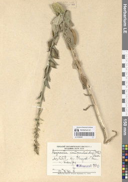
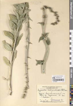
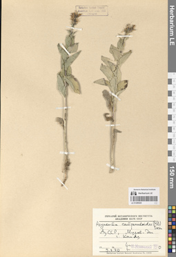
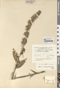
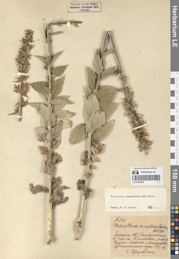
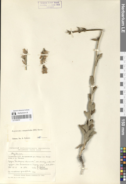
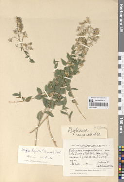
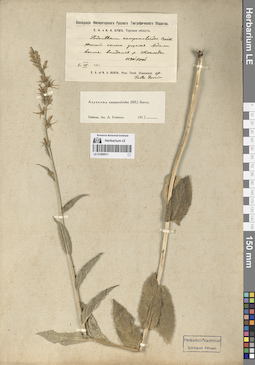
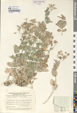
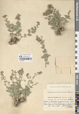
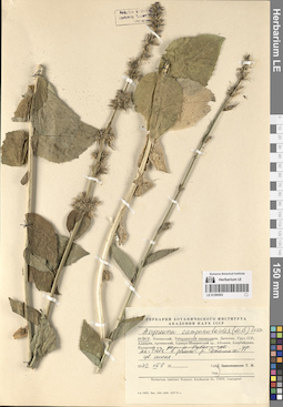
LE 01290529
Asyneuma campanuloides (M. Bieb. ex Sims) Bornm. det. Menitsky, Yuri Leonardovich at 1970
Collectors: Menitsky, Yuri Leonardovich Collection date: 10.07.1970. Administrative regions: AZ - Azerbaijan. Groups of specimens: Образцы сектора Кавказа; Соглашение Минобрнауки №075-15-2021-1056Original label text:АзССР, хребет Муров-даг, гора Капяз [= Кяпаз, Кяпас].
Coordinates (geographic position): 40° 18′ 13.86″ N, 46° 15′ 43.54″ EComment: 10.7.70
Ю. Меницкий
Azerbaijan, the Murovdağ ridge, the Mount Kapaz.
Record creation: 2024-08-04, Daria Yudova, PhotoScan D2.Citation: Specimen LE 01290529 // Virtual herbarium of Komarov Botanical Institute RAS — http://re.herbariumle.ru/0129052910.07.1970
Coll. Yu. Menitsky
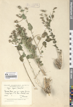
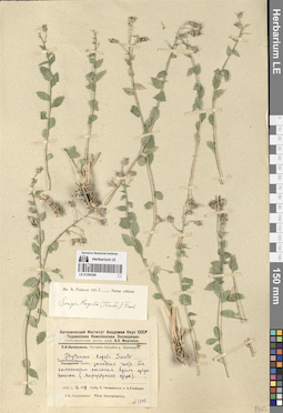
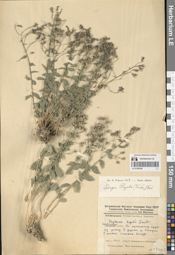
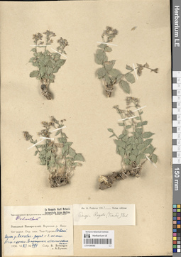
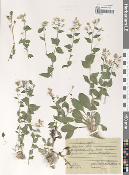
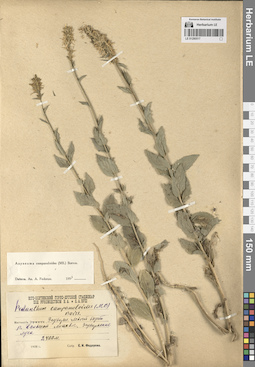
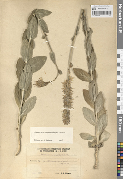
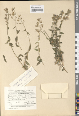
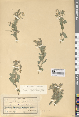
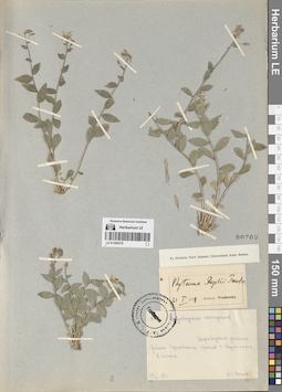
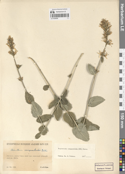
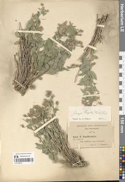
LE 01290398
Sergia regelii (Trautv.) Fed.
Collectors: Kamelin, Rudolph Vladimirovich Collection date: 07.1965. Administrative regions: TJ - Tajikistan. Groups of specimens: Образцы сектора Средней АзииOriginal label text:Таджикистан, Фанские горы, спуск с котловины Кули-калон в долину Кштута, в 5 км выше к. Панджруд, скалы.
Coordinates (geographic position): 39° 22′ 34.91″ N, 68° 3′ 48.27″ EComment: 1965-VII
Р. Камелин
Tajikistan, Fan Mountains, descent from the Kuli-Kalon basin into the Kshtut valley, 5 km above the village of Panjrud, rocks.
07.1965
Coll. R. Kamelin
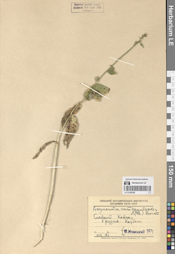
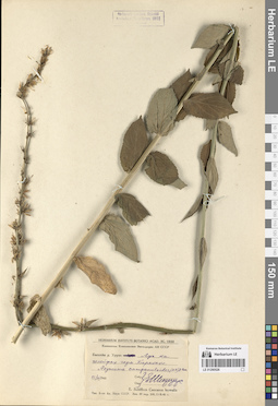
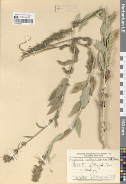
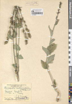
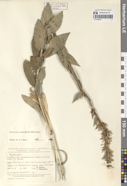
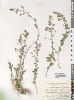
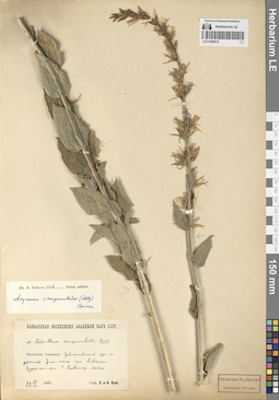
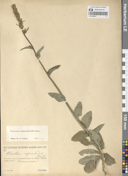
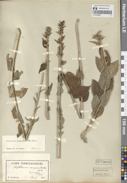
LE 01290528
Asyneuma campanuloides (M. Bieb. ex Sims) Bornm. det. Menitsky, Yuri Leonardovich at 1971
Collectors: Menitsky, Yuri Leonardovich Collection date: 08.1971. Administrative regions: GE - Georgia. Groups of specimens: Образцы сектора Кавказа; Соглашение Минобрнауки №075-15-2021-1056Original label text:Главный Кавказ. Грузия: Казбеги.
Coordinates (geographic position): 42° 41′ 53.85″ N, 44° 30′ 52.29″ EComment: VIII.71
Ю. Меницкий
Main Caucasus. Georgia: Kazbegi.
08.1971Coll. Yu. Menitsky
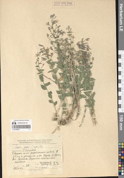
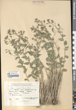
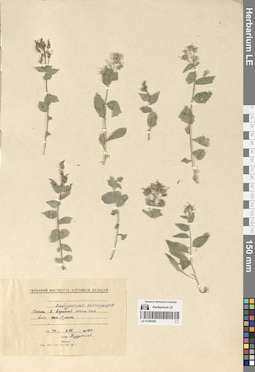
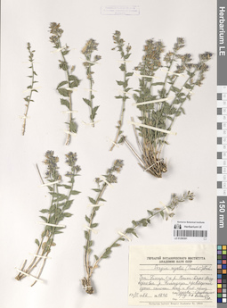
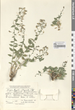
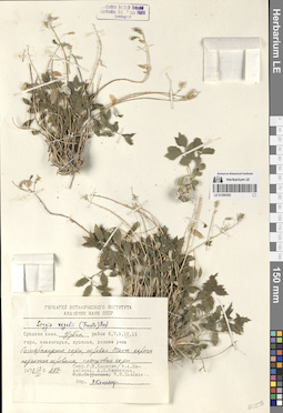
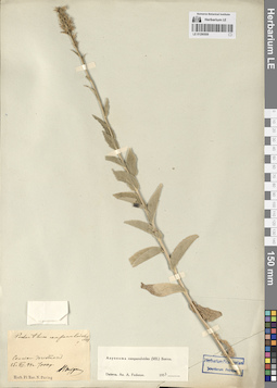
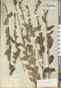
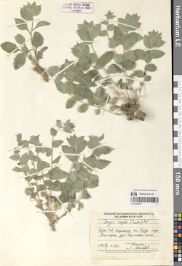
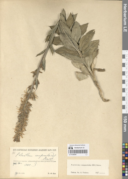
LE 01290397
Sergia regelii (Trautv.) Fed. det. Kamelin, Rudolph Vladimirovich
Collectors: Filatov, E. I.; Zavedeev, V. N. Field collecting number: 92. Collection date: 28.06.1961. Administrative regions: TJ - Tajikistan. Groups of specimens: Образцы сектора Средней АзииOriginal label text:Таджикистан. Северный склон Зеравшанского хребта, 1,5 км к западу от кишлака Чориф, h = 2300 м. Асс. Гречихово-розарийно-типчаковый арчовник.
Coordinates (geographic position): 39° 31′ 43.11″ N, 67° 49′ 42.49″ E 2300 m a.s.l.Comment: № 92
28.VI.1961 г.
Филатов Е. И., Заведеев В. Н.
Tajikistan. Northern slope of the Zeravshan ridge, 1.5 km west of the village of Chorif, h = 2300 m.
Record creation: 2024-08-04, Daria Yudova, PhotoScan D2.Citation: Specimen LE 01290397 // Virtual herbarium of Komarov Botanical Institute RAS — http://re.herbariumle.ru/01290397№ 92
28.06.1961
Coll. E. I. Filatov, V. N. Zavedeev
LE 01290527
Asyneuma campanuloides (M. Bieb. ex Sims) Bornm. det. Menitsky, Yuri Leonardovich at 1970
Collectors: Menitsky, Yuri Leonardovich Collection date: 13.07.1969. Administrative regions: GE - Georgia. Groups of specimens: Образцы сектора Кавказа; Соглашение Минобрнауки №075-15-2021-1056Original label text:Грузия, Ахалкалакский район, берег озера Хозапини, близ села Ховети.
Coordinates (geographic position): 41° 15′ 32.87″ N, 43° 14′ 4.79″ EComment: 13.VII.1969
Ю. Меницкий
Georgia, Akhalkalaki region, shore of Lake Khozapini, near the village of Khoveti.
13.07.1969Coll. Yu. Menitsky
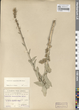
LE 01290396
Sergia regelii (Trautv.) Fed. det. Fedorov, Andrey Aleksandrovich at 1954
Collectors: Ovczinnikov, Pavel Nikolaevich; Slobodov, A.A. Field collecting number: 1100. Collection date: 16.07.1932. Administrative regions: TJ - Tajikistan. Expedition: Таджикская Комплексная Экспедиция. Геоботаническая группа проф, Б.А. Федченко (1932)Groups of specimens: Образцы сектора Средней АзииOriginal label text:Зеравшанский хребет, западная часть. По каменистым склонам вдоль озера Нежгон [Нежегон] (Маргузарские [Маргузорские] озера).
Coordinates (geographic position): 39° 13′ 20.41″ N, 67° 47′ 55.12″ EComment: 16.VII.1932
П. Овчинников и А. Слободов
Zeravshan ridge, western part. Along the rocky slopes along Lake Nezhgon [Nezhegon] (Marguzar [Marguzor] lakes).
Record creation: 2024-08-04, Daria Yudova, PhotoScan D2.Citation: Specimen LE 01290396 // Virtual herbarium of Komarov Botanical Institute RAS — http://re.herbariumle.ru/0129039616.07.1932
Coll. P. Ovczinnikov, A. Slobodov
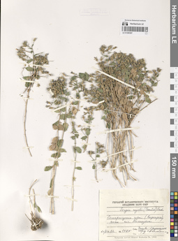
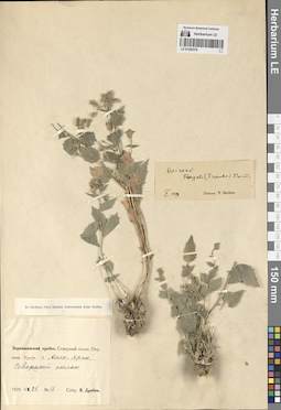
LE 01290526
Asyneuma campanuloides (M. Bieb. ex Sims) Bornm.
Collectors: Shiffers, Evgenia Vladimirovna Collection date: 23.07.1945. Administrative regions: RU - Karachayevo-Cherkesiya. Expedition: Кавказская комплексная экспедиция АН СССР (1945 -1946)Groups of specimens: Образцы сектора Кавказа; Соглашение Минобрнауки №075-15-2021-1056; E. Schiffers. Caucasus borealis.Original label text:Бассейн р. Урупа. Луг на шлейфах горы Баранахи.
Coordinates (geographic position): 43° 58′ 17.86″ N, 41° 17′ 8.64″ EComment: 23.VII.1945
Е. Шифферс
Karachayevo-Cherkesiya, basin of the Urup river. Meadow on the Baranakha mount.
23.07.1945Coll. E. Shiffers
LE 01290395
Sergia regelii (Trautv.) Fed.
Field collecting number: 6745. Collection date: 05.08.1963. Administrative regions: TJ - Tajikistan. Groups of specimens: Образцы сектора Средней АзииOriginal label text:Таджикистан. Северный склон Зеравшанского хребта. Бассейн реки Кштут. Ущелье кишлака Негнот. В трещинах скал. H = 2400 м.
Coordinates (geographic position): 39° 21′ 28.68″ N, 68° 1′ 7.7″ EComment: № 6745
5.VIII.1963
C. Юнусов, Абдусалямова и Каримова
Tajikistan. Northern slope of the Zeravshan ridge. Basin of the Kshtut River. Gorge of Negnot village. In the cracks of the rocks. H = 2400 m.
Record creation: 2024-08-04, Daria Yudova, PhotoScan D2.Citation: Specimen LE 01290395 // Virtual herbarium of Komarov Botanical Institute RAS — http://re.herbariumle.ru/01290395№ 6745
5.08.1963
Coll. S. Junussov, Abdusalyamova and Karimova
LE 01290525
Asyneuma campanuloides (M. Bieb. ex Sims) Bornm.
Collectors: Menitsky, Yuri Leonardovich Collection date: 09.07.1970. Administrative regions: AZ - Azerbaijan. Groups of specimens: Образцы сектора Кавказа; Соглашение Минобрнауки №075-15-2021-1056Original label text:АзССР, хребет Муров-даг, гора Капяз [= Кяпаз, Кяпас].
Coordinates (geographic position): 40° 18′ 13.86″ N, 46° 15′ 43.54″ EComment: 9.7.70
Ю. Меницкий
Azerbaijan, the Murovdağ ridge, the Mount Kapaz.
Record creation: 2024-08-04, Daria Yudova, PhotoScan D2.Citation: Specimen LE 01290525 // Virtual herbarium of Komarov Botanical Institute RAS — http://re.herbariumle.ru/012905259.07.1970
Coll. Yu. Menitsky
LE 01290394
Sergia regelii (Trautv.) Fed. det. Fedorov, Andrey Aleksandrovich at 1954
Collectors: Ovczinnikov, Pavel Nikolaevich; Slobodov, A.A. Collection date: 14.06.1932. Administrative regions: TJ - Tajikistan. Expedition: Таджикская Комплексная Экспедиция. Геоботаническая группа проф, Б.А. Федченко (1932)Groups of specimens: Образцы сектора Средней АзииOriginal label text:Зеравшанский хребет. По каменистому крутому склону в ущелье реки Кштут в районе кишлака Кштут.
Coordinates (geographic position): 39° 21′ 23.66″ N, 68° 2′ 51.35″ EComment: 14.VI.1932
П. Овчинников и А. Слободов
Zeravshan ridge. Along a rocky steep slope in the gorge of the Kshtut River in the area of the village of Kshtut.
Record creation: 2024-08-04, Daria Yudova, PhotoScan D2.Citation: Specimen LE 01290394 // Virtual herbarium of Komarov Botanical Institute RAS — http://re.herbariumle.ru/0129039414.06.1932
Coll. P. Ovczinnikov, A. Slobodov
LE 01290524
Asyneuma campanuloides (M. Bieb. ex Sims) Bornm. det. Menitsky, Yuri Leonardovich at 1970
Collectors: Menitsky, Yuri Leonardovich Collection date: 09.07.1970. Administrative regions: AZ - Azerbaijan. Groups of specimens: Образцы сектора Кавказа; Соглашение Минобрнауки №075-15-2021-1056Original label text:АзССР, хребет Муров-даг, гора Капяз [= Кяпаз, Кяпас].
Coordinates (geographic position): 40° 18′ 13.86″ N, 46° 15′ 43.54″ EComment: 9.7.70
Ю. Меницкий
Azerbaijan, the Murovdağ ridge, the Mount Kapaz.
Record creation: 2024-08-04, Daria Yudova, PhotoScan D2.Citation: Specimen LE 01290524 // Virtual herbarium of Komarov Botanical Institute RAS — http://re.herbariumle.ru/012905249.07.1970
Coll. Yu. Menitsky
LE 01290393
Sergia regelii (Trautv.) Fed.
Collectors: Kudrjaschev, Serafim Nikovajevich Field collecting number: 285. Collection date: 03.08.1940. Administrative regions: UZ - Uzbekistan. Groups of specimens: Образцы сектора Средней АзииOriginal label text:Байсунская экспедиция
Coordinates (geographic position): 38° 16′ 2.52″ N, 67° 12′ 11.66″ EComment: Скалы в верхней части сая близ кишлака Аулат.
№ 285
3.VIII.1940
Кудряшев
Baysun expedition
Record creation: 2024-08-04, Daria Yudova, PhotoScan D2.Citation: Specimen LE 01290393 // Virtual herbarium of Komarov Botanical Institute RAS — http://re.herbariumle.ru/01290393Rocks in the upper part of the sai near the village of Aulat.
№ 285
3.08.1940
Сoll. Kudrjaschev
LE 01290523
Asyneuma campanuloides (M. Bieb. ex Sims) Bornm. det. Fedorov, Andrey Aleksandrovich at 1965
Collectors: Shiffers, Evgenia Vladimirovna Collection date: 04.07.1937. Administrative regions: RU - Stavropol'skiy Kray. Groups of specimens: Образцы сектора Кавказа; Соглашение Минобрнауки №075-15-2021-1056Original label text:Северный Кавказ. Кисловодск.
Coordinates (geographic position): 43° 54′ 28.7″ N, 42° 44′ 50.42″ EComment: 4.VII.1937
Е. Шифферс
North Caucasus. Stavropol'skiy Krayю Kislovodsk.
Record creation: 2024-08-04, Daria Yudova, PhotoScan D2.Citation: Specimen LE 01290523 // Virtual herbarium of Komarov Botanical Institute RAS — http://re.herbariumle.ru/012905234.07.1937
Coll. E. Shiffers
LE 01290392
Sergia regelii (Trautv.) Fed. det. Fedorov, Andrey Aleksandrovich at 1954
Collectors: Botschantzev, Victor Petrovič; Butkov, Aleksandr Yakovlevich Field collecting number: 494. Collection date: 27.06.1936. Administrative regions: UZ - Uzbekistan. Groups of specimens: Образцы сектора Средней АзииOriginal label text:Западный Памиро-алай. Верховья реки Яккабаг-дарья. Окрестности кишлака Таш-Курган. Левый берег реки Яккобаг-дарья к З от кишлака Таш-Курган. В трещинах известняковых скал.
Coordinates (geographic position): 38° 56′ 1.29″ N, 66° 52′ 48.58″ EComment: № 494
27.VI.1936
В. Бочанцев и А. Бутков
Western Pamir-Alai. The upper reaches of the Yakkabag-Darya river. The outskirts of the village of Tash-Kurgan. The left bank of the Yakkobag-Darya river to the west from the village of Tash-Kurgan. In the cracks of limestone rocks.
Record creation: 2024-08-04, Daria Yudova, PhotoScan D2.Citation: Specimen LE 01290392 // Virtual herbarium of Komarov Botanical Institute RAS — http://re.herbariumle.ru/01290392№ 494
27.06.1936
Coll. V. Botschantzev, A. Butkov
LE 01290522
Asyneuma campanuloides (M. Bieb. ex Sims) Bornm. det. Menitsky, Yuri Leonardovich at 1970
Collection date: 24.08.1970. Administrative regions: GE - Georgia. Groups of specimens: Образцы сектора Кавказа; Соглашение Минобрнауки №075-15-2021-1056Original label text:Грузия: Казбеги. Близ села Сноу [= Сно].
Coordinates (geographic position): 42° 36′ 43.76″ N, 44° 38′ 33.59″ EComment: 25.VIII.70
В. Чунов
Georgia: Kazbegi. The Sno village.
Record creation: 2024-08-04, Daria Yudova, PhotoScan D2.Citation: Specimen LE 01290522 // Virtual herbarium of Komarov Botanical Institute RAS — http://re.herbariumle.ru/0129052225.08.1970
Coll. V. Chunov
LE 01290391
Sergia regelii (Trautv.) Fed.
Collectors: Kamelin, Rudolph Vladimirovich Field collecting number: 1242. Collection date: 13.06.1982. Groups of specimens: Образцы сектора Средней АзииOriginal label text:Западный Гиссар, бассейн реки Кашка-Дарья-Аксу, верховья реки Гиляндара [Гиляндарья], правобережье, сухие склоны южной и восточной экспозиции.
Comment: № 1242
13.VI.1982
Закавк.-Среднеазиат. отряд
Р. В. Камелин и др.
Western Gissar, basin of the Kashka-Darya-Aksu river, upper reaches of the Gilandara [Gilandarya] river, right bank, dry slopes of southern and eastern exposure.
Record creation: 2024-08-04, Daria Yudova, PhotoScan D2.Citation: Specimen LE 01290391 // Virtual herbarium of Komarov Botanical Institute RAS — http://re.herbariumle.ru/01290391№ 1242
13.06.1982
Coll. R. V. Kamelin
LE 01290520
Asyneuma campanuloides (M. Bieb. ex Sims) Bornm. det. Fedorov, Andrey Aleksandrovich at 1963
Collectors: Kutscherovskaya, Sofia Evgenevna Field collecting number: 240. Collection date: 09.08.1936. Administrative regions: GE - Georgia. Groups of specimens: Образцы сектора Кавказа; Соглашение Минобрнауки №075-15-2021-1056Original label text:Грузинская ССР. Джавахетия, к северу от Тамбовки, между Кызыл-Килиссе [= Кизыл-Килиса] и Забитокдж [= Забат-агджа]
Coordinates (geographic position): 41° 38′ 47.9″ N, 43° 48′ 43.08″ EComment: Субальпийские луга.
9.VIII.36 г.
С. Кучеровская
Georgia. Javakheti, north of Tambovka, between Kyzyl-Kilisse [= Kizil-Kilissa] and Zabat-agja. Subalpine meadows.
Record creation: 2024-08-04, Daria Yudova, PhotoScan D2.Citation: Specimen LE 01290520 // Virtual herbarium of Komarov Botanical Institute RAS — http://re.herbariumle.ru/012905209.08.1936
Coll. S. Kutscherovskaya
LE 01290390
Sergia regelii (Trautv.) Fed.
Collectors: Kamelin, Rudolph Vladimirovich Field collecting number: 759. Collection date: 04.06.1982. Administrative regions: TM - Turkmenistan. Groups of specimens: Образцы сектора Средней АзииOriginal label text:Узбекская ССР, хребет Кугитанг близ кишлака Ходжай-филь-ата, ущелье Эмердара.
Coordinates (geographic position): 37° 56′ 57.44″ N, 66° 38′ 49.75″ EComment: № 759
4.VI.1982
Р. В. Камелин и др.
Uzbek SSR, Kugitang ridge near the village of Khojay-fil-ata, Emerdara gorge.
Record creation: 2024-08-04, Daria Yudova, PhotoScan D2.Citation: Specimen LE 01290390 // Virtual herbarium of Komarov Botanical Institute RAS — http://re.herbariumle.ru/01290390№ 759
4.06.1982
Coll. R.V. Kamelin et al.
LE 01290519
Asyneuma campanuloides (M. Bieb. ex Sims) Bornm. det. Fedorov, Andrey Aleksandrovich at 1963
Collectors: Tzvelev, Nikolai Nikolaievich; Czerepanov, Sergei Kirillovich Collection date: 12.07.1960. Administrative regions: GE - Georgia. Groups of specimens: Образцы сектора Кавказа; Соглашение Минобрнауки №075-15-2021-1056Original label text:Грузинская ССР. Богдановский район. Между селом Богдановка и озером Ханчали. Среди больших камней по склону невысокой гряды на восточном берегу озера, h = 1750 м.
Coordinates (geographic position): 41° 16′ 2.69″ N, 43° 34′ 40.11″ E 1750 m a.s.l.Comment: № 930
12.VII.1960
Н. Цвелев, С. Черепанов
Цветки синевато-фиолетовые
Georgia. Between the village of Bogdanovka and Lake Khanchali. Among large stones on the slope of a low ridge on the eastern shore of the lake, h = 1750 m.
Record creation: 2024-08-04, Daria Yudova, PhotoScan D2.Citation: Specimen LE 01290519 // Virtual herbarium of Komarov Botanical Institute RAS — http://re.herbariumle.ru/0129051912.07.1960
Coll. N. Tzvelev, S. Czerepanov
LE 01290389
Sergia regelii (Trautv.) Fed. det. Kamelin, Rudolph Vladimirovich
Collectors: Strizhova, Tamara Georgievna Field collecting number: 737. Collection date: 27.06.1961. Administrative regions: TJ - Tajikistan. Groups of specimens: Образцы сектора Средней АзииOriginal label text:Таджикистан Северный, Зеравшанский хребет. Правобережье реки Кштут между кишлаками Кульяли и Шишкат. В трещинах скал, h - 1500 м.
Coordinates (geographic position): 39° 23′ 2.9″ N, 68° 2′ 42.73″ E 1500 m a.s.l.Comment: № 737
27 июня 1961 г.
Стрижова Т.
Northern Tajikistan, Zeravshan Range. The right bank of the Kshtut River between the villages of Kulyali and Shishkat. In rock cracks, h - 1500 m.
№ 737
27.06.1961
Coll. T. Strizhova
LE 01290518
Asyneuma campanuloides (M. Bieb. ex Sims) Bornm. det. Fedorov, Andrey Aleksandrovich at 1963
Collectors: Tzvelev, Nikolai Nikolaievich; Czerepanov, Sergei Kirillovich Field collecting number: 930. Collection date: 12.07.1960. Administrative regions: GE - Georgia. Groups of specimens: Образцы сектора Кавказа; Соглашение Минобрнауки №075-15-2021-1056Original label text:Грузинская ССР. Богдановский район. Между селом Богдановка и озером Ханчали. Среди больших камней по склону невысокой гряды на восточном берегу озера, h = 1750 м.
Coordinates (geographic position): 41° 16′ 2.69″ N, 43° 34′ 40.11″ E 1750 m a.s.l.Comment: № 930
12.VII.1960
Н. Цвелев, С. Черепанов
Цветки синевато-фиолетовые
Georgia. Between the village of Bogdanovka and Lake Khanchali. Among large stones on the slope of a low ridge on the eastern shore of the lake, h = 1750 m.
Record creation: 2024-08-04, Daria Yudova, PhotoScan D2.Citation: Specimen LE 01290518 // Virtual herbarium of Komarov Botanical Institute RAS — http://re.herbariumle.ru/0129051812.07.1960
Coll. N. Tzvelev, S. Czerepanov
LE 01290388
Sergia regelii (Trautv.) Fed.
Collectors: Kamelin, Rudolph Vladimirovich Field collecting number: 1124. Collection date: 11.06.1982. Administrative regions: UZ - Uzbekistan. Groups of specimens: Образцы сектора Средней АзииOriginal label text:Западный Гиссар, долина реки Аксу между селами Гисарак и Кызылэмчек. Скалы и осыпи.
Coordinates (geographic position): 39° 2′ 35.48″ N, 67° 18′ 21.5″ EComment: № 1124
11.VI.1982
Закавк.-Среднеазиат. отряд Р. В. Камелин и др.
Western Gissar, Aksu river valley between the villages of Gisarak and Kyzylemchek. Rocks and scree.
Record creation: 2024-08-04, Daria Yudova, PhotoScan D2.Citation: Specimen LE 01290388 // Virtual herbarium of Komarov Botanical Institute RAS — http://re.herbariumle.ru/01290388№ 1124
11.06.1982
Coll. R. V. Kamelin et al.
LE 01290517
Asyneuma campanuloides (M. Bieb. ex Sims) Bornm. det. Fedorov, Andrey Aleksandrovich at 1954
Subregion: South Ossetia, Dzau district. Groups of specimens: Образцы сектора Кавказа; Соглашение Минобрнауки №075-15-2021-1056Original label text:Згубири. Левый борт реки Большой Лиахвы. Згубирьские луга. 2400 м.
Coordinates (geographic position): 42° 33′ 13.91″ N, 44° 9′ 23.74″ E 2400 m a.s.l.Comment: 1938 г.
Е.И. Федорова
Zgubiri. The left side of the Bolshaya Liakhva River. Zgubir meadows. 2400 m.
1938
Coll. E. I. Fedorova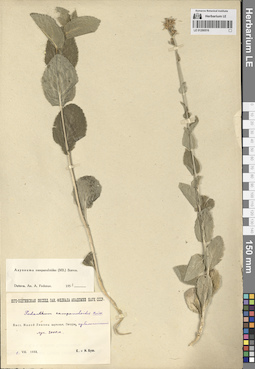
LE 01290516
Asyneuma campanuloides (M. Bieb. ex Sims) Bornm. det. Fedorov, Andrey Aleksandrovich at 1954
Collectors: Busch, Elizaveta Aleksandrovna; Busch, Nikolai Adolfovich (Nikolaj Adolfowitsch) Collection date: 01.08.1933. Subregion: South Ossetia. Groups of specimens: Образцы сектора Кавказа; Соглашение Минобрнауки №075-15-2021-1056Original label text:Бассейн Малой Лиахвы. Верховья, Пачуры [= Пачурисцкали], субальпийский луг. 2000 м.
Coordinates (geographic position): 42° 23′ 54.85″ N, 44° 19′ 56.43″ E 2000 m a.s.l.Comment: 1.VIII.1933
Е. и Н. Буш
The Malaya Liakhva basin. Upper reaches, Pachur [= Pachuristskali], subalpine meadow. 2000 m.
01.08.1933Coll. E. Busch, N. Busch
LE 01290387
Sergia regelii (Trautv.) Fed.
Collectors: Kamelin, Rudolph Vladimirovich Field collecting number: 1565. Collection date: 17.06.1982. Administrative regions: UZ - Uzbekistan. Groups of specimens: Образцы сектора Средней АзииOriginal label text:Самаркандские горы (Кыркарча) ниже поселка Аманкутан.
Comment: № 1565
17.VI.1982
Закавк.-Среднеазиат. отряд Р. В. Камелин и др.
Samarkand Mountains (Kyrkarcha) below the village of Amankutan.
Record creation: 2024-08-04, Daria Yudova, PhotoScan D2.Citation: Specimen LE 01290387 // Virtual herbarium of Komarov Botanical Institute RAS — http://re.herbariumle.ru/01290387№ 1565
17.06.1982
Coll. R.V. Kamelin et al.
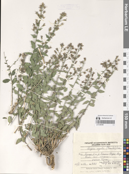
LE 01290515
Asyneuma campanuloides (M. Bieb. ex Sims) Bornm. det. Fedorov, Andrey Aleksandrovich at 1954
Collectors: Abramov, Ivan Ivanovich Collection date: 21.07.1938. Subregion: South Ossetia, Dzau district. Groups of specimens: Образцы сектора Кавказа; Соглашение Минобрнауки №075-15-2021-1056Original label text:Местность Эрмани. Субальпийский луг на склоне выше села Эдис.
Coordinates (geographic position): 42° 32′ 14.18″ N, 44° 14′ 9.2″ EComment: 21.VII.1938 г.
И. И. Абрамов
Ermani area. Subalpine meadow on the slope above the village of Edis.
Record creation: 2024-08-04, Daria Yudova, PhotoScan D2.Citation: Specimen LE 01290515 // Virtual herbarium of Komarov Botanical Institute RAS — http://re.herbariumle.ru/0129051521.07.1938
Coll. I. I. Abramov
LE 01290386
Sergia regelii (Trautv.) Fed.
Field collecting number: 1021. Collection date: 11.06.1982. Administrative regions: UZ - Uzbekistan. Groups of specimens: Образцы сектора Средней АзииOriginal label text:Западный Гиссар, бассейн рек Кашка-Дарья-Аксу выше поселка Мираки, ущелье Чаккы.
Coordinates (geographic position): 39° 1′ 35.42″ N, 67° 11′ 37.59″ EComment: № 1021
11.VI.1982
Закавказско-Среднеазиатский отряд, Р. В. Камелин и др.
Western Gissar, the Kashka-Darya-Aksu river basin above the village of Miraki, the Chakky gorge.
№ 1021
11.06.1982
Coll. Transcaucasian-Central Asian detachment, R.V. Kamelin et al.
LE 01290514
Asyneuma campanuloides (M. Bieb. ex Sims) Bornm. det. Fedorov, Andrey Aleksandrovich at 1954
Collectors: Krylov, Porphyriy Nikitich; Steinberg, Elisabeth Ivanovna Collection date: 08.07.1916. Administrative regions: GE - Georgia. Groups of specimens: Образцы сектора Кавказа; Соглашение Минобрнауки №075-15-2021-1056Original label text:Кавказ. Тифлисская губерния. Горийский уезд. Имеретинские холмы между селом Бакуриани и горой Цхра-Цхаро, луга на склонах.
Coordinates (geographic position): 41° 43′ 8.44″ N, 43° 31′ 43.09″ EComment: 8 июля 1916 г.
П. Н. Крылов, Е. И. Штейнберг
Georgia. Imereti hills between the village of Bakuriani and Mount Tskhra-Tskharo, meadows on the slopes.
Record creation: 2024-08-04, Daria Yudova, PhotoScan D2.Citation: Specimen LE 01290514 // Virtual herbarium of Komarov Botanical Institute RAS — http://re.herbariumle.ru/0129051408.07.1916
Coll. P. N. Krylov, E. I. Steinberg
LE 01290385
Sergia regelii (Trautv.) Fed.
Collectors: Sabirov B.; Vassilczenko, Ivan Tikhonovich Field collecting number: 136. Collection date: 02.08.1955. Administrative regions: UZ - Uzbekistan. Groups of specimens: Образцы сектора Средней АзииOriginal label text:Западный Гиссар, Узбекская ССР. Бассейн реки Тупаланг, в районе озера Айгыр-Куль.
Coordinates (geographic position): 38° 54′ 51.46″ N, 67° 56′ 1.51″ EComment: № 136
2.VIII.1955
Сабиров, Васильченко
Western Gissar, Uzbekistan. Tupalang River basin, in the area of Lake Aygyr-Kul.
№ 136
2.08.1955
Coll. B. Sabirov, I. T. Vassilczenko

LE 01290513
Asyneuma campanuloides (M. Bieb. ex Sims) Bornm. det. Fedorov, Andrey Aleksandrovich at 1954
Collectors: Busch, Elizaveta Aleksandrovna; Busch, Nikolai Adolfovich (Nikolaj Adolfowitsch) Collection date: 12.08.1925. Administrative regions: RU - North Ossetia. Groups of specimens: Образцы сектора Кавказа; Соглашение Минобрнауки №075-15-2021-1056Original label text:Дигория. Левый склон Карагомского ущелья, покрытый широколиственными породами и сосной, на месте бывшего сосняка. 1650 - 1680 м.
Coordinates (geographic position): 42° 51′ 5.97″ N, 43° 42′ 5.26″ EComment: 12.VIII.1925
Е. и Н. Буш
Digoria. The left slope of the Karagom gorge, covered with broad-leaved trees and pine, on the site of a former pine forest. 1650 - 1680 m.
Record creation: 2024-08-04, Daria Yudova, PhotoScan D2.Citation: Specimen LE 01290513 // Virtual herbarium of Komarov Botanical Institute RAS — http://re.herbariumle.ru/0129051312.08.1925
Coll. E. Busch, N. Busch
LE 01290384
Sergia regelii (Trautv.) Fed.
Collectors: Sabirov B.; Vassilczenko, Ivan Tikhonovich Field collecting number: 136. Collection date: 02.08.1955. Administrative regions: UZ - Uzbekistan. Groups of specimens: Образцы сектора Средней АзииOriginal label text:Западный Гиссар, Узбекская ССР. Бассейн реки Тупаланг, в районе озера Айгыр-Куль.
Coordinates (geographic position): 38° 54′ 51.46″ N, 67° 56′ 1.51″ EComment: № 136
2.VIII.1955
Сабиров, Васильченко
Western Gissar, Uzbekistan. Tupalang River basin, in the area of Lake Aygyr-Kul.
№ 136
2.08.1955
Coll. Sabirov, Vassilczenko
LE 01290512
Asyneuma campanuloides (M. Bieb. ex Sims) Bornm. det. Fedorov, Andrey Aleksandrovich at 1956
Collectors: Busch, Elizaveta Aleksandrovna; Busch, Nikolai Adolfovich (Nikolaj Adolfowitsch) Collection date: 29.06.1925. Administrative regions: RU - Kabardino-Balkarskaya Respublika. Groups of specimens: Образцы сектора Кавказа; Соглашение Минобрнауки №075-15-2021-1056Original label text:Балкария, Рцывашки. Субальпийский луг на урочище Урта-тала при впадении Цуралан-кол в Рцывашку. 2018 м.
Coordinates (geographic position): 2018 m a.s.l.Comment: 29.VI.1925
Е. и Н. Буш
Balkaria, Rtsyvashki. Subalpine meadow on the Urta-tala at the confluence of the Tsuralan-kol and the Rtsyvashka. 2018 m.
Record creation: 2024-08-04, Daria Yudova, PhotoScan D2.Citation: Specimen LE 01290512 // Virtual herbarium of Komarov Botanical Institute RAS — http://re.herbariumle.ru/0129051229.06.1925
Coll. E. Busch, N. Busch
LE 01290383
Sergia regelii (Trautv.) Fed. det. Kamelin, Rudolph Vladimirovich
Collectors: Kamelin, Rudolph Vladimirovich; Mikhajlova, Marina Аntonovna; Mishenkova, Antonina Petrovna Field collecting number: 227. Collection date: 14.04.1977. Administrative regions: UZ - Qashqadaryo Province. Groups of specimens: Образцы сектора Средней АзииOriginal label text:Самаркандские горы, перевал Тахта-карача, подножье перевала, сланцевые горы.
Coordinates (geographic position): 39° 15′ 11.13″ N, 66° 54′ 53.48″ EComment: № 227
14.IV.1977
Р. В. Камелин, М. А. Михайлова, А. П. Мишенкова
Samarkand mountains, Takhta-karacha pass, foot of the pass, slate mountains.
Record creation: 2024-08-04, Daria Yudova, PhotoScan D2.Citation: Specimen LE 01290383 // Virtual herbarium of Komarov Botanical Institute RAS — http://re.herbariumle.ru/01290383№ 227
14.04.1977
Coll. R. V. Kamelin, M. A. Mikhailova, A. P. Mishenkova
LE 01290511
Asyneuma campanuloides (M. Bieb. ex Sims) Bornm. det. Fedorov, Andrey Aleksandrovich at 1954
Collectors: Busch, Elizaveta Aleksandrovna; Busch, Nikolai Adolfovich (Nikolaj Adolfowitsch) Collection date: 02.07.1911. Administrative regions: RU - Kabardino-Balkarskaya Respublika. Groups of specimens: Образцы сектора Кавказа; Соглашение Минобрнауки №075-15-2021-1056Original label text:Южный склон ущелья Адыла [= Адылсу] выше впадения реки Шхельды. 6500' - 7000'.
Coordinates (geographic position): 43° 13′ 40.23″ N, 42° 39′ 26.04″ EComment: 2.VII.1911
Е. А. Буш, Н. А. Буш
The southern slope of the Adyl [=Adylsu] gorge, above the confluence of the Shkhelda River. 6500' - 7000'.
Record creation: 2024-08-04, Daria Yudova, PhotoScan D2.Citation: Specimen LE 01290511 // Virtual herbarium of Komarov Botanical Institute RAS — http://re.herbariumle.ru/012905112.07.1911
Coll. N. Busch, E. Busch
LE 01290382
Sergia regelii (Trautv.) Fed.
Collectors: Jarmolenko, Alexander Viktorovich Field collecting number: 400. Collection date: 28.08.1931. Administrative regions: UZ - Uzbekistan. Groups of specimens: Образцы сектора Средней АзииOriginal label text:Узбекистан. Байсунский район. Вершина хребта Кетмень-чапты, по скалам, 3435 м н.у.м.
Coordinates (geographic position): 38° 28′ 7.87″ N, 67° 25′ 0.26″ EComment: № 400
28.VIII.1931
A. Jarmolenko
Uzbekistan. Baysun district. The summit of the Ketmen-chapty ridge, on the rocks, 3435 m above sea level.
Record creation: 2024-08-04, Daria Yudova, PhotoScan D2.Citation: Specimen LE 01290382 // Virtual herbarium of Komarov Botanical Institute RAS — http://re.herbariumle.ru/01290382№ 400
28.08.1931
Coll. A. Jarmolenko
LE 01290510
Asyneuma campanuloides (M. Bieb. ex Sims) Bornm. det. Fedorov, Andrey Aleksandrovich at 1954
Collectors: Busch, Elizaveta Aleksandrovna; Busch, Nikolai Adolfovich (Nikolaj Adolfowitsch) Field collecting number: 22. Collection date: 23.07.1929. Administrative regions: RU - North Ossetia. Expedition: Юго-Осетинская экспедиция АН СССР ()Groups of specimens: Образцы сектора Кавказа; Соглашение Минобрнауки №075-15-2021-1056Original label text:Рокское ущелье, субальпийский луг на вершине горы Кадисэр-угардан. 2400 м.
Coordinates (geographic position): 42° 36′ 53.91″ N, 44° 9′ 33.76″ E 2400 m a.s.l.Comment: 23.VII.1929
Е. и Н. Буш
Ossetia. Roksky Gorge, subalpine meadow on the top of Mount Kadisar-Ugardan. 2400 m.
Record creation: 2024-08-04, Daria Yudova, PhotoScan D2.Citation: Specimen LE 01290510 // Virtual herbarium of Komarov Botanical Institute RAS — http://re.herbariumle.ru/0129051023.07.1929
Coll. E. Busch, N. Busch

LE 01290381
Sergia regelii (Trautv.) Fed. det. Fedorov, Andrey Aleksandrovich at 1954
Collectors: Kudrjaschev, Serafim Nikovajevich; Sumnevich, Georgy Prokopyevich Field collecting number: 862. Collection date: 11.07.1938. Administrative regions: UZ - Qashqadaryo Province. Groups of specimens: Образцы сектора Средней АзииOriginal label text:Бассейн реки Кашка-Дарьи. Западная часть Зеравшанского хребта. Южные склоны. Скалы на гребне увала между Хазаляк и Аякчи.
Coordinates (geographic position): 39° 16′ 26.77″ N, 66° 44′ 57.19″ EComment: № 862
11.VII.1938
С. Н. Кудряшев, Г. П. Сумневич
The Kashka-Darya River basin. The western part of the Zeravshan Range. Southern slopes. Rocks on the ridge between Khazalyak and Ayakchi.
№ 862
11.07.1938
Coll. S. N. Kudrjaschev, G. P. Sumnevich
LE 01290509
Asyneuma campanuloides (M. Bieb. ex Sims) Bornm. det. Fedorov, Andrey Aleksandrovich at 1954
Collectors: Puring, Nicolai Ivanovich Collection date: 15.07.1894. Administrative regions: RU - Dagestan. Groups of specimens: Образцы сектора Кавказа; Соглашение Минобрнауки №075-15-2021-1056Original label text:Салты [= Салта]. Дагестан.
7000 ф.
15.VII.1894Н. Пуринг
Dagestan. The Salta village.
Record creation: 2024-08-04, Daria Yudova, PhotoScan D2.Citation: Specimen LE 01290509 // Virtual herbarium of Komarov Botanical Institute RAS — http://re.herbariumle.ru/012905097000'.
15.07.1894
Coll. N. Puring
LE 01290380
Sergia regelii (Trautv.) Fed.
Collectors: Botschantzev, Victor Petrovič Field collecting number: 152. Collection date: 15.10.1970. Administrative regions: UZ - Uzbekistan. Groups of specimens: Образцы сектора Средней АзииOriginal label text:Узбекистан. Сурхандарьинская обл. Хр. Кугитанг. Окрестности кишлака Тангидувал. В трещинах известняковых скал.
Coordinates (geographic position): 37° 58′ 0″ N, 66° 44′ 0″ EComment: № 152
15.X.1970
В. Бочанцев
Uzbekistan. Surkhandarya region. Kugitang Ridge. The outskirts of the village of Tangiduval. In the cracks of limestone rocks.
№ 152
15.10.1970
Coll. V. Botschantzev
LE 01290508
Asyneuma campanuloides (M. Bieb. ex Sims) Bornm. det. Fedorov, Andrey Aleksandrovich at 1954
Collectors: Sredinsky, Nicolai Konstantinovich Collection date: 07.1873. Administrative regions: GE - Georgia. Groups of specimens: Образцы сектора Кавказа; Соглашение Минобрнауки №075-15-2021-1056Original label text:Чутхаро
7200'
Июль 1873
N. Sredinsky
Georgia. The Chutkharo mount.
7200'
July 1873
N. Sredinsky
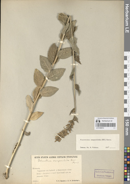
LE 01290379
Sergia regelii (Trautv.) Fed.
Collectors: Popov, Mikhail Grigorevich (Popow) Collection date: 28.06.1927. Administrative regions: UZ - Uzbekistan. Groups of specimens: Образцы сектора Средней АзииOriginal label text:Ширабадская долина. Гребень Кугитанга против села Кизил-алма, в [теньге].
Coordinates (geographic position): 37° 53′ 42.44″ N, 66° 40′ 5.79″ EComment: 28/VI - 27 г.
М. Г. Попов
Shirabad Valley. Kugitang Ridge against the Kizil-alma Village.
28.06.1927
Coll. M. G. Popov
LE 01290507
Asyneuma campanuloides (M. Bieb. ex Sims) Bornm. det. Fedorov, Andrey Aleksandrovich at 1954
Field collecting number: 223. Administrative regions: GE - Georgia. Groups of specimens: Образцы сектора Кавказа; Соглашение Минобрнауки №075-15-2021-1056Original label text:№ 223
Coordinates (geographic position): 42° 43′ 20.59″ N, 43° 10′ 9.34″ EComment: Чутхара
7200'
Июль
№ 223
Record creation: 2024-08-04, Daria Yudova, PhotoScan D2.Citation: Specimen LE 01290507 // Virtual herbarium of Komarov Botanical Institute RAS — http://re.herbariumle.ru/01290507Georgia. The Chutkharo mount.
7200'
July
LE 01290378
Sergia regelii (Trautv.) Fed.
Collectors: Botschantzev, Victor Petrovič; Butkov, Aleksandr Yakovlevich Field collecting number: 494. Collection date: 27.06.1936. Administrative regions: UZ - Uzbekistan. Groups of specimens: Образцы сектора Средней АзииOriginal label text:Западный Памиро-алай. Верховья реки Яккабаг-дарья. Окрестности кишлака Таш-Курган. Левый берег реки Яккабаг-дарья к З от кишлака Таш-Курган. В трещинах известняковых скал.
Coordinates (geographic position): 38° 56′ 11.83″ N, 66° 52′ 49.27″ EComment: № 494
27.VI.1936
В. Бочанцев, А. Ботков
Western Pamir-Alai. The upper reaches of the Yakkabag-Darya river. The outskirts of the Tash-Kurgan village. The left bank of the Yakkabag-Darya river to the west from the Tash-Kurgan village. In the cracks of limestone rocks.
Record creation: 2024-08-04, Daria Yudova, PhotoScan D2.Citation: Specimen LE 01290378 // Virtual herbarium of Komarov Botanical Institute RAS — http://re.herbariumle.ru/01290378№ 494
27.06.1936
Coll. V. Botschantzev, A. Butkov
LE 01290506
Asyneuma campanuloides (M. Bieb. ex Sims) Bornm. det. Fedorov, Andrey Aleksandrovich at 1954
Collectors: Busch, Elizaveta Aleksandrovna; Busch, Nikolai Adolfovich (Nikolaj Adolfowitsch) Collection date: 23.08.1930. Subregion: South Ossetia, Dzau district. Expedition: Юго-Осетинская экспедиция АН СССР ()Groups of specimens: Образцы сектора Кавказа; Соглашение Минобрнауки №075-15-2021-1056Original label text:Джомах [= Джомага, Дзомаг], ущелье Сомих, левый борт, сенокосный субальпийский луг. 2000 м.
Coordinates (geographic position): 42° 33′ 56.36″ N, 44° 2′ 35.71″ E 2000 m a.s.l.Comment: 23.VIII.1930
Е. и Н. Буш
Jomakh, Somikh gorge, left side, subalpine meadow. 2000 m.
Record creation: 2024-08-04, Daria Yudova, PhotoScan D2.Citation: Specimen LE 01290506 // Virtual herbarium of Komarov Botanical Institute RAS — http://re.herbariumle.ru/0129050623.08.1930
Coll. E. Busch, N. Busch
LE 01290377
Sergia regelii (Trautv.) Fed.
Collectors: Kamelin, Rudolph Vladimirovich; Makhmedov, A. M. Field collecting number: 64. Collection date: 13.05.1979. Administrative regions: UZ - Uzbekistan. Groups of specimens: Образцы сектора Средней АзииOriginal label text:Узбекская ССР, окрестности поселка Ургут, горы Ала-аярон, урочище Таш-иисык, скалы.
Coordinates (geographic position): 39° 21′ 23.41″ N, 67° 15′ 12.14″ EComment: № 64
13.5.1979
Камелин, Махмедов
Uzbek SSR, the vicinity of the village of Urgut, the Ala-ayaron mountains, the Tash-iisyk, rocks.
Record creation: 2024-08-04, Daria Yudova, PhotoScan D2.Citation: Specimen LE 01290377 // Virtual herbarium of Komarov Botanical Institute RAS — http://re.herbariumle.ru/01290377№ 64
13.05.1979
Coll. Kamelin, Makhmedov
LE 01290505
Asyneuma campanuloides (M. Bieb. ex Sims) Bornm. det. Fedorov, Andrey Aleksandrovich at 1954
Collectors: Doluchanov, Armen Georgievich Collection date: 21.07.1928. Administrative regions: AZ - Azerbaijan. Expedition: Геоботаническое обследование пастбищ ССР Азербайджана по заданию Наркомзема (1929)Groups of specimens: Образцы сектора Кавказа; Соглашение Минобрнауки №075-15-2021-1056Original label text:Transcaucasia, Azerbajdjan, prov. et distr. Gandzha, in m-te Koshkar-dagh.
Coordinates (geographic position): 40° 22′ 28.29″ N, 46° 0′ 12.23″ EComment: 21.VII.28
A. Doluchanov
Azerbaijan, the Koshkar mount.
Record creation: 2024-08-04, Daria Yudova, PhotoScan D2.Citation: Specimen LE 01290505 // Virtual herbarium of Komarov Botanical Institute RAS — http://re.herbariumle.ru/0129050521.07.1928
Coll. A. Doluchanov
LE 01290376
Sergia regelii (Trautv.) Fed.
Collectors: Drobow, Vasilii Petrovich Field collecting number: 16. Collection date: 25.06.1929. Administrative regions: UZ - Uzbekistan. Groups of specimens: Образцы сектора Средней АзииOriginal label text:Зеравшанский хребет. Северный склон. Окрестности кишлака Ургут. Гора Алла-яран. Северный склон.
Coordinates (geographic position): 39° 21′ 23.41″ N, 67° 15′ 12.14″ EComment: № 16
25.VI.1929
В. Дробов
Zeravshan Range. Northern slope. Environs of the Urgut village. Mount Alla-yaran. Northern slope.
Record creation: 2024-08-04, Daria Yudova, PhotoScan D2.Citation: Specimen LE 01290376 // Virtual herbarium of Komarov Botanical Institute RAS — http://re.herbariumle.ru/01290376№ 16
25.06.1929
Coll. V. Drobow
LE 01290504
Asyneuma campanuloides (M. Bieb. ex Sims) Bornm. det. Fedorov, Andrey Aleksandrovich at 1954
Collectors: Busch, Elizaveta Aleksandrovna; Busch, Nikolai Adolfovich (Nikolaj Adolfowitsch) Field collecting number: 31. Collection date: 29.07.1929. Subregion: South Ossetia, Dzau district. Expedition: Юго-Осетинская экспедиция АН СССР ()Groups of specimens: Образцы сектора Кавказа; Соглашение Минобрнауки №075-15-2021-1056Original label text:Сбийское ущелье, субальпийский луг выше урочища Жуар-рах. 2400 м. Асс. 3.
Coordinates (geographic position): 42° 33′ 59.53″ N, 44° 10′ 2.07″ E 2400 m a.s.l.Comment: 29.VII.1929
Е. и Н. Буш
Sbiyskoe gorge, subalpine meadow above the Zhuar-rah area. 2400 m.
Record creation: 2024-08-04, Daria Yudova, PhotoScan D2.Citation: Specimen LE 01290504 // Virtual herbarium of Komarov Botanical Institute RAS — http://re.herbariumle.ru/0129050429.07.1929
Coll. E. Busch, N. Busch
LE 01290375
Sergia regelii (Trautv.) Fed. det. Fedorov, Andrey Aleksandrovich at 1954
Collectors: Komarov, Vladimir Leontjevich Collection date: 07.1893. Administrative regions: UZ - Uzbekistan. Groups of specimens: Образцы сектора Средней АзииOriginal label text:Flora Seravschanica
Coordinates (geographic position): 39° 9′ 8.1″ N, 67° 33′ 10.86″ EComment: Schut (fl. Kaschka-daria).
Alt. 7000 pd.
Зона хвойных деревьев (Juniperus).
VII.1893
V. L. Komarov
Flora Seravschanica
Record creation: 2024-08-04, Daria Yudova, PhotoScan D2.Citation: Specimen LE 01290375 // Virtual herbarium of Komarov Botanical Institute RAS — http://re.herbariumle.ru/01290375The Schut village (the Kaschka-daria river).
Alt. 7000 pd.Coniferous tree zone (Juniperus).
07.1893
Coll. V. L. Komarov
LE 01290503
Asyneuma campanuloides (M. Bieb. ex Sims) Bornm. det. Zaikonnikova, Tamara Ivanovna
Collectors: Zaikonnikova, Tamara Ivanovna Collection date: 08.08.1972. Administrative regions: RU - Karachayevo-Cherkesiya. Groups of specimens: Образцы сектора Кавказа; Соглашение Минобрнауки №075-15-2021-1056Original label text:РСФСР, Тебердинский заповедник, урочище Ак-Тюбе в долине реки Джамагат.
Coordinates (geographic position): 43° 27′ 46.84″ N, 41° 47′ 42.51″ EComment: Цветки синие.
8.VIII.1972
Заиконникова Т. И.
Karachayevo-Cherkesiya. Teberda Nature Reserve, Ak-Tyube area in the valley of the Dzhamagat River.The flowers are blue.
Record creation: 2024-08-04, Daria Yudova, PhotoScan D2.Citation: Specimen LE 01290503 // Virtual herbarium of Komarov Botanical Institute RAS — http://re.herbariumle.ru/012905038.08.1972
Coll. T. I. Zaikonnikova