View
Add
Copy
Edit
Delete
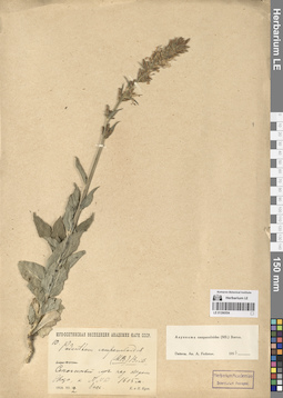
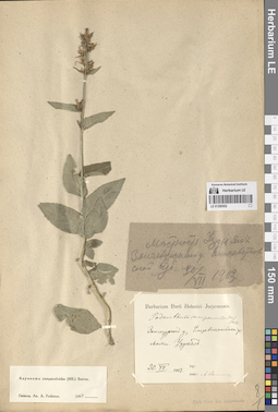
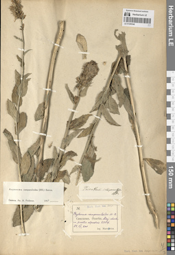
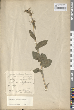
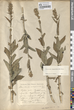
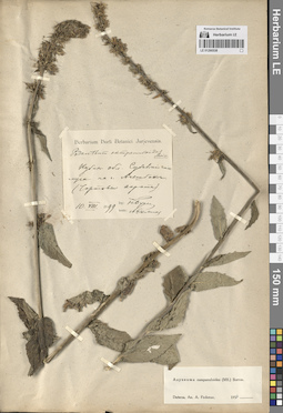
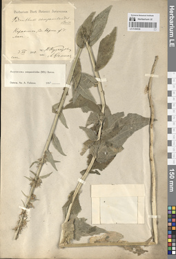
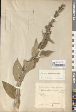
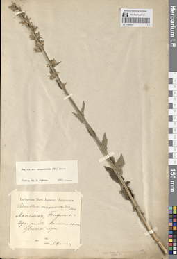
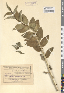
LE 01290554
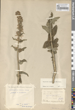
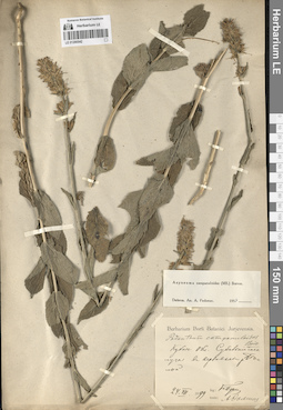
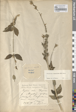
Asyneuma campanuloides (M. Bieb. ex Sims) Bornm. det. Fedorov, Andrey Aleksandrovich at 1954
Collectors: Busch, Elizaveta Aleksandrovna; Busch, Nikolai Adolfovich (Nikolaj Adolfowitsch) Field collecting number: 10. Collection date: 12.07.1928. Subregion: South Ossetia, Dzau District. Expedition: Юго-Осетинская экспедиция АН СССР ()Groups of specimens: Образцы сектора Кавказа; Соглашение Минобрнауки №075-15-2021-1056Original label text:Сенокосный луг над озером Эрцо, к NNW. 1615 м. 1 асс.
Coordinates (geographic position): 42° 28′ 24.22″ N, 43° 45′ 19.41″ E 1615 m a.s.l.Comment: 1928.VII.12
Е. и Н. Буш
South Ossetia, Ertso Lake. 1615 m.
Record creation: 2024-08-04, Daria Yudova, PhotoScan D2.Citation: Specimen LE 01290554 // Virtual herbarium of Komarov Botanical Institute RAS — http://re.herbariumle.ru/0129055412.07.1928
Coll. E. Busch, N. Busch
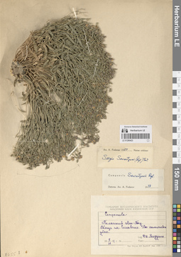
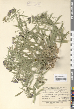
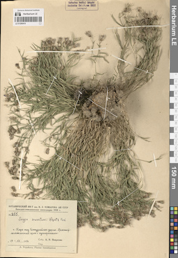
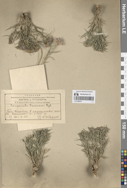
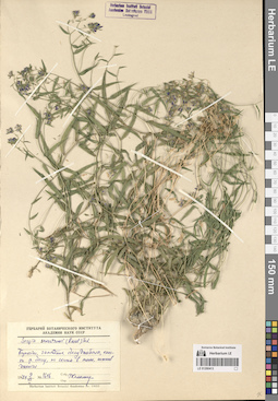
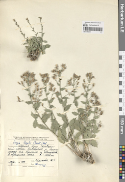
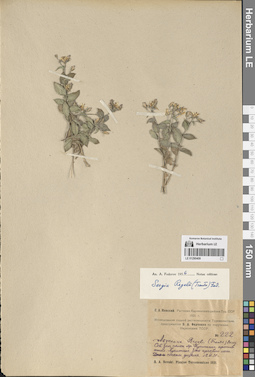
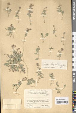
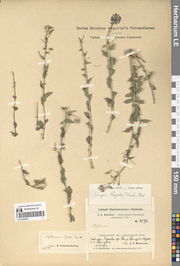
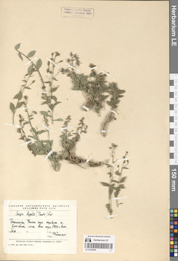
LE 01290423
Sergia sewerzowii (Regel) Fed. det. Fedorov, Andrey Aleksandrovich at 1954
Collectors: Roldugin, I.I. Collection date: 09.06.1951. Administrative regions: KZ - Kazakhstan. Groups of specimens: Образцы сектора Средней АзииOriginal label text:Таласский Ала-Тау. Вблизи поселка Сеславино. На каменистом утесе.
Coordinates (geographic position): 42° 26′ 6.69″ N, 70° 11′ 35.98″ EComment: 9.VI.1951
И. И. Ролдугин
Kazakhstan, Talas Ala-Tau. Near the village of Seslavino. On a rocky cliff.
Record creation: 2024-08-04, Daria Yudova, PhotoScan D2.Citation: Specimen LE 01290423 // Virtual herbarium of Komarov Botanical Institute RAS — http://re.herbariumle.ru/012904239.06.1951
Coll. I. I. Roldugin
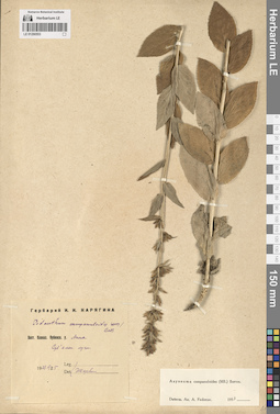
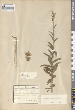
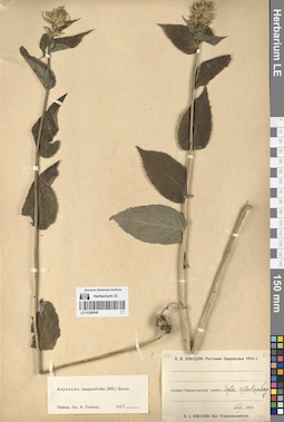
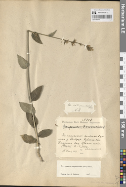
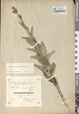
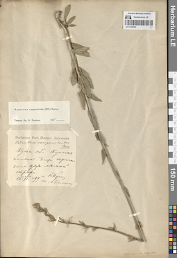
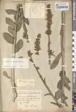
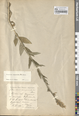
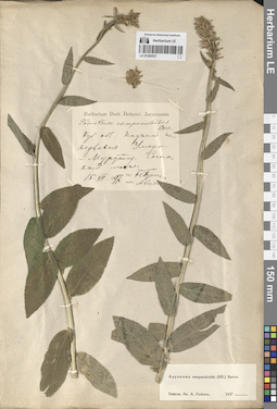
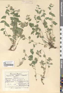
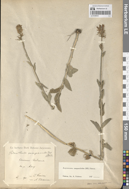
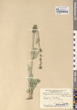
LE 01290553
Asyneuma campanuloides (M. Bieb. ex Sims) Bornm. det. Fedorov, Andrey Aleksandrovich at 1954
Collectors: Karjagin (Karyagin), Ivan Ivanovich Collection date: 25.06.1927. Administrative regions: AZ - Azerbaijan. Groups of specimens: Образцы сектора Кавказа; Соглашение Минобрнауки №075-15-2021-1056Original label text:Вост. Кавказ. Кубинск. у. Аных. Субальпийские луга.
1927.VI.25
И. КарягинAzerbaijan. The Anykh village. Subalpine meadows.
Record creation: 2024-08-04, Daria Yudova, PhotoScan D2.Citation: Specimen LE 01290553 // Virtual herbarium of Komarov Botanical Institute RAS — http://re.herbariumle.ru/0129055325.06.1927
Coll. I. Karjagin
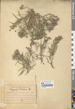
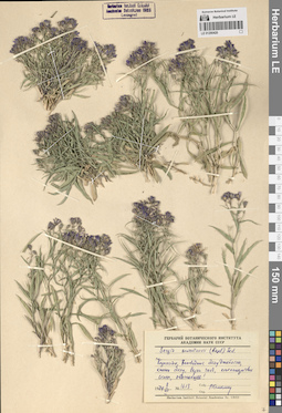
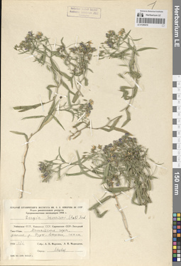
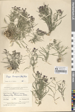
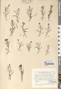
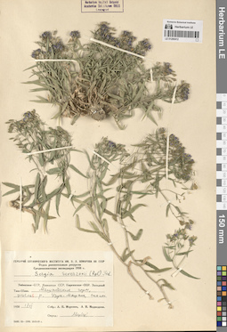
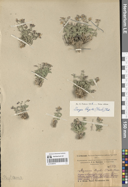
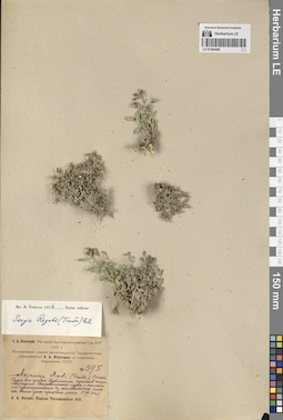
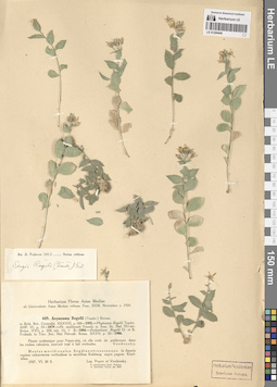
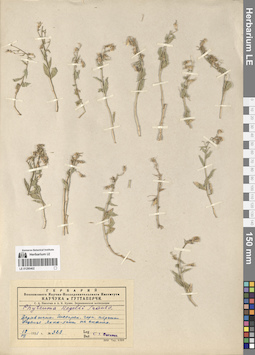
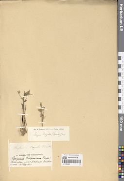
LE 01290422
Sergia sewerzowii (Regel) Fed.
Collectors: Linczevski, Igor Alexandrovich Field collecting number: 493. Collection date: 25.07.1933. Administrative regions: KZ - Kazakhstan. Groups of specimens: Образцы сектора Средней АзииOriginal label text:КазАССР. Хр. Таласский Ала-Тау. Каньон реки Ак-су близ кардона Мансура, южные камен. склоны и скалы.
Coordinates (geographic position): 42° 18′ 34.39″ N, 70° 46′ 40.56″ EComment: № 493
25.VII.1933
И. А. Линчевский
Kazakhstan, Talas Ala-Tau Ridge. Canyon of the Ak-Su River near the Mansur cordon, southern slopes and rocks.
Record creation: 2024-08-04, Daria Yudova, PhotoScan D2.Citation: Specimen LE 01290422 // Virtual herbarium of Komarov Botanical Institute RAS — http://re.herbariumle.ru/01290422№ 493
25.07.1933
Coll. I. A. Linczevski
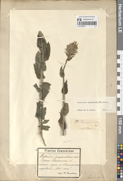
LE 01290552
Asyneuma campanuloides (M. Bieb. ex Sims) Bornm. det. Fedorov, Andrey Aleksandrovich at 1954
Collection date: 30.07.1903. Groups of specimens: Образцы сектора Кавказа; Соглашение Минобрнауки №075-15-2021-1056Original label text:Зангезурский у., Елизаветпольской губ. Местность Узун ял.
Comment: 30.VII.1903
Zangezursky district, Elizavetpol province. Uzun yal area.
Record creation: 2024-08-04, Daria Yudova, PhotoScan D2.Citation: Specimen LE 01290552 // Virtual herbarium of Komarov Botanical Institute RAS — http://re.herbariumle.ru/0129055230.07.1903
LE 01290421
Sergia sewerzowii (Regel) Fed. det. Medvedeva, L. I. удалить
Collectors: Markova, Lydia Pavlovna; Medvedeva, L. I. удалить Collection date: 17.06.1958. Administrative regions: KZ - Kazakhstan. Groups of specimens: Образцы сектора Средней АзииOriginal label text:Казахская ССР. Западный Тянь-Шань, Машатские горы, ущелье реки Узун-Машат, скалы.
Coordinates (geographic position): 42° 21′ 52.41″ N, 70° 11′ 38.64″ EComment: 17.VI.1958
Л. П. Маркова, Л. И. Медведева
Kazakhstan, Western Tien Shan, Mashat Mountains, Uzun-Mashat River gorge, rocks.
Record creation: 2024-08-04, Daria Yudova, PhotoScan D2.Citation: Specimen LE 01290421 // Virtual herbarium of Komarov Botanical Institute RAS — http://re.herbariumle.ru/0129042117.06.1958
Coll. L. P. Markova, L. I. Medvedeva
LE 01290551
Asyneuma campanuloides (M. Bieb. ex Sims) Bornm. det. Fedorov, Andrey Aleksandrovich at 1954
Collectors: Desoulavy, Numa Avgustovich Collection date: 07.1900. Administrative regions: RU - Karachayevo-Cherkesiya. Groups of specimens: Образцы сектора Кавказа; Соглашение Минобрнауки №075-15-2021-1056Original label text:Верховья Кубана. Подальпийские луга до 8000'
Coordinates (geographic position): 43° 27′ 55.97″ N, 42° 4′ 58.4″ EComment: VII.1900
legit N. Desoulavy
Karachayevo-Cherkesiya. Upper reaches of the Kuban river. The Uchkulan village. Subalpine meadows up to 8000'.
Record creation: 2024-08-04, Daria Yudova, PhotoScan D2.Citation: Specimen LE 01290551 // Virtual herbarium of Komarov Botanical Institute RAS — http://re.herbariumle.ru/01290551VII.1900
Coll. N. Desoulavy
LE 01290420
Sergia sewerzowii (Regel) Fed.
Collectors: Kamelin, Rudolph Vladimirovich Field collecting number: 1613. Collection date: 08.07.1974. Administrative regions: KZ - Kazakhstan. Groups of specimens: Образцы сектора Средней АзииOriginal label text:Казахстан, заповедник Аксу Джебаглы [= Аксу-Жабаглы], каньон Аксу, верхняя часть, конгломератовые скалы, обычнейше!
Coordinates (geographic position): 42° 19′ 17.41″ N, 70° 32′ 24.8″ EComment: 8.VII.1974
Р. Камелин
Kazakhstan, Aksu Dzhebagly [= Aksu-Zhabagly] reserve, Aksu canyon, upper part, conglomerate rocks, most common!
Record creation: 2024-08-04, Daria Yudova, PhotoScan D2.Citation: Specimen LE 01290420 // Virtual herbarium of Komarov Botanical Institute RAS — http://re.herbariumle.ru/012904208.07.1974
Coll. R. Kamelin
LE 01290550
Asyneuma campanuloides (M. Bieb. ex Sims) Bornm. det. Fedorov, Andrey Aleksandrovich at 1954
Field collecting number: 149. Collection date: 14.07.1898. Administrative regions: RU - North Ossetia. Groups of specimens: Образцы сектора Кавказа; Соглашение Минобрнауки №075-15-2021-1056Original label text:Caucasus. Ossetia. Prope Alagir et Mamisson.
Comment: 1898
leg. A. Mecz., prof. B. Zinger
№ 149
На горных лугах близ Мамисона.
Цветы синие.
14 го июля
№ 149
North Ossetia. In the mountain meadows near Mamison.The flowers are blue.14.07.1898
Coll. A. Mecz., prof. B. Zinger
LE 01290419
Sergia sewerzowii (Regel) Fed.
Collectors: Pojarkova, Antonina Ivanovna Field collecting number: 255. Collection date: 19.07.1950. Administrative regions: KZ - Kazakhstan. Expedition: Западно-тяньшанская экспедиция 1950 г. ()Groups of specimens: Образцы сектора Средней АзииOriginal label text:Гора Кара-тау. Бостугайское ущелье. Каменисто-мелкоземистый склон с кустарниками.
Coordinates (geographic position): 43° 11′ 51.44″ N, 70° 16′ 51.23″ EComment: 19.VII.1950
А. И. Пояркова
Kazakhstan. Mount Kara-tau. Bostugai Gorge. Rocky-fine-earth slope with bushes.
Record creation: 2024-08-04, Daria Yudova, PhotoScan D2.Citation: Specimen LE 01290419 // Virtual herbarium of Komarov Botanical Institute RAS — http://re.herbariumle.ru/0129041919.07.1950
Coll. A. I. Pojarkova
LE 01290549
Asyneuma campanuloides (M. Bieb. ex Sims) Bornm. det. Fedorov, Andrey Aleksandrovich at 1954
Collectors: Kikodze, Elizaveta Iosifovna Collection date: 08.1914. Administrative regions: GE - Georgia. Groups of specimens: Образцы сектора Кавказа; Соглашение Минобрнауки №075-15-2021-1056Original label text:Аджаро-Имеретинский хребет. Гора Шавиабад [= Шавнабад].
Coordinates (geographic position): 41° 48′ 24.67″ N, 42° 32′ 40.16″ EComment: VIII.1914
Е. И. Кикодзе
Georgia. The Shavnabad mount.
Record creation: 2024-08-04, Daria Yudova, PhotoScan D2.Citation: Specimen LE 01290549 // Virtual herbarium of Komarov Botanical Institute RAS — http://re.herbariumle.ru/0129054908.1914
Coll. E. I. Kikodze
LE 01290418
Sergia sewerzowii (Regel) Fed.
Collectors: Markova, Lydia Pavlovna; Medvedeva, L. I. удалить Collection date: 17.06.1958. Administrative regions: KZ - Kazakhstan. Expedition: Среднеазиатская экспедиция Отдела растительных ресурсов Ботанического института им. В. Л. Комарова АН СССР (1958)Groups of specimens: Образцы сектора Средней АзииOriginal label text:Казахская ССР. Западный Тянь-Шань. Машатские горы, ущелье реки Узун-Машат, скалы.
Coordinates (geographic position): 42° 25′ 47.82″ N, 70° 3′ 14.36″ EComment: 17.VI.1958
Л. П. Маркова, Л. И. Медведева
Kazakhstan, Western Tien Shan. Mashat mountains, Uzun-Mashat river gorge, rocks.
Record creation: 2024-08-04, Daria Yudova, PhotoScan D2.Citation: Specimen LE 01290418 // Virtual herbarium of Komarov Botanical Institute RAS — http://re.herbariumle.ru/0129041817.06.1958
Coll. L. P. Markova, L. I. Medvedeva
LE 01290548
Asyneuma campanuloides (M. Bieb. ex Sims) Bornm. det. Fedorov, Andrey Aleksandrovich at 1954
Collectors: Marcowicz, Vasilii Vasilevicz Collection date: 27.07.1900. Administrative regions: RU - North Ossetia. Groups of specimens: Образцы сектора Кавказа; Соглашение Минобрнауки №075-15-2021-1056Original label text:Caucasus. Ossetia. Adaj-choch
Coordinates (geographic position): 42° 44′ 50.18″ N, 43° 52′ 6.38″ EComment: in pratis alpestris, 8500 f.
27.VII.900
leg. Marcowicz
North Ossetia. The Adaj-choch mount.
27.07.1900Coll. V. Marcowicz
LE 01290417
Sergia sewerzowii (Regel) Fed. det. Pavlov, Nikolai Vasilievich
Collectors: Pavlov, Nikolai Vasilievich Field collecting number: 351. Collection date: 25.06.1931. Administrative regions: KZ - Kazakhstan. Groups of specimens: Образцы сектора Средней АзииOriginal label text:Горы Каратау, в расщелинах скал на вершинах близ реки Сая-су.
Coordinates (geographic position): 42° 53′ 40.46″ N, 70° 42′ 36.03″ EComment: 25.VI.1931
№ 351
Н. В. Павлов
Karatau Mountains, in rock crevices on the peaks near the Saya-su river.
Record creation: 2024-08-04, Daria Yudova, PhotoScan D2.Citation: Specimen LE 01290417 // Virtual herbarium of Komarov Botanical Institute RAS — http://re.herbariumle.ru/01290417№ 351
25.06.1931
Coll. N. V. Pavlov
LE 01290547
Asyneuma campanuloides (M. Bieb. ex Sims) Bornm. det. Fedorov, Andrey Aleksandrovich at 1954
Field collecting number: 229. Collection date: 15.06.1903. Administrative regions: RU - Karachayevo-Cherkesiya. Groups of specimens: Образцы сектора Кавказа; Соглашение Минобрнауки №075-15-2021-1056Original label text:На сенокосной полянке в долине р. Теберда. Кубанская область. Баталпашинский отдел. Цветок синий. ([...]) В. - 4200 ф.
Comment: 15 июня 1903
leg. [...]
Karachayevo-Cherkesiya. In the valley of the Teberda River.
Record creation: 2024-08-04, Daria Yudova, PhotoScan D2.Citation: Specimen LE 01290547 // Virtual herbarium of Komarov Botanical Institute RAS — http://re.herbariumle.ru/0129054715.06.1903
Coll. [...]
LE 01290416
Sergia sewerzowii (Regel) Fed. det. Fedorov, Andrey Aleksandrovich at 1961
Collectors: Botschantzev, Victor Petrovič Field collecting number: 510. Collection date: 21.06.1959. Administrative regions: KZ - Kazakhstan. Groups of specimens: Образцы сектора Средней АзииOriginal label text:Южный Казахстан. Таласский Алатау. Ущелье реки Аксу. Каменистые склоны.
Coordinates (geographic position): 42° 15′ 55.32″ N, 70° 49′ 5.83″ EComment: № 510
21.VI.1959
Бочанцев В. П.
Southern Kazakhstan. Talas Alatau. Aksu river gorge. Rocky slopes.
№ 51021.06.1959
Coll. V. P. Botschantzev
LE 01290546
Asyneuma campanuloides (M. Bieb. ex Sims) Bornm. det. Fedorov, Andrey Aleksandrovich at 1954
Collectors: Busch, Nikolai Adolfovich (Nikolaj Adolfowitsch) Collection date: 29.08.1897. Administrative regions: GE - Abkhazia. Groups of specimens: Образцы сектора Кавказа; Соглашение Минобрнауки №075-15-2021-1056Original label text:Абхазия. Субальпийские луга по Лахтинскому хребту.
Coordinates (geographic position): 43° 10′ 43.78″ N, 41° 20′ 36.81″ EComment: 29.VIII.1897
Н. Буш
Abkhazia. Subalpine meadows on the Lakhta ridge.
29.08.1897
Coll. N. Busch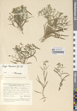
LE 01290415
Sergia sewerzowii (Regel) Fed. det. Kamelin, Rudolph Vladimirovich at 1964
Collectors: Pjataeva, A. D. Field collecting number: 190. Collection date: 21.06.1959. Administrative regions: KZ - Kazakhstan. Groups of specimens: Образцы сектора Средней АзииOriginal label text:Западный Тянь-Шань. Заповедник Джебоглы-Аксу. Спуск в ущелье реки Аксу. Каменисто-скалистый правый берег, с середины арча.
Coordinates (geographic position): 42° 16′ 52.87″ N, 70° 35′ 52.85″ EComment: № 190
21.VI.1959
Пятаева
Western Tien Shan. Dzhebogly-Aksu [= Aksu-Zhabagly] Nature Reserve. Descent into the Aksu River gorge. Rocky right bank
Record creation: 2024-08-04, Daria Yudova, PhotoScan D2.Citation: Specimen LE 01290415 // Virtual herbarium of Komarov Botanical Institute RAS — http://re.herbariumle.ru/01290415№ 190
21.06.1959
Coll. Pjataeva
LE 01290545
Asyneuma campanuloides (M. Bieb. ex Sims) Bornm. det. Fedorov, Andrey Aleksandrovich at 1954
Collectors: Kusnetzov N.; Popow, P. Collection date: 20.06.1911. Administrative regions: AZ - Azerbaijan. Groups of specimens: Образцы сектора Кавказа; Соглашение Минобрнауки №075-15-2021-1056Original label text:Село Сарыбаш, Закатальский округ.
Coordinates (geographic position): 41° 31′ 24.2″ N, 47° 4′ 44.9″ EComment: Гора Алла-гёзе [= Алагез].
Azerbaijan, the Sarybash village, the Alagez mount.
Record creation: 2024-08-04, Daria Yudova, PhotoScan D2.Citation: Specimen LE 01290545 // Virtual herbarium of Komarov Botanical Institute RAS — http://re.herbariumle.ru/0129054520.06.1911
Coll. N. Kusnetztov, P. Popov
LE 01290414
Sergia sewerzowii (Regel) Fed. det. Medvedeva, L. I. удалить
Collectors: Markova, Lydia Pavlovna; Medvedeva, L. I. удалить Collection date: 24.07.1958. Groups of specimens: Образцы сектора Средней АзииOriginal label text:Киргизия. Западный Тянь-Шань. Таласский Ала-Тау, заповедник Аксу-Джебоглы, урочище Жетым-сай, скалы.
Comment: 24.VII.1958
Л. Маркова, Л. Медведева
Kyrgyzstan. Western Tien Shan. Talas Ala-Tau, Aksu-Dzhebogly nature reserve, Zhetym-sai, rocks.
Record creation: 2024-08-04, Daria Yudova, PhotoScan D2.Citation: Specimen LE 01290414 // Virtual herbarium of Komarov Botanical Institute RAS — http://re.herbariumle.ru/0129041424.07.1958
Coll. L. Markova, L. Medvedeva
LE 01290544
Asyneuma campanuloides (M. Bieb. ex Sims) Bornm. det. Fedorov, Andrey Aleksandrovich at 1954
Collectors: Busch, Nikolai Adolfovich (Nikolaj Adolfowitsch) Collection date: 03.07.1899. Administrative regions: RU - Krasnodarskiy Kray. Groups of specimens: Образцы сектора Кавказа; Соглашение Минобрнауки №075-15-2021-1056Original label text:Кубанская область. Субальпийские луга в верховьях р. Бугунча, между г. Маркопиджем и хребтом Магишо.
Coordinates (geographic position): 43° 49′ 7.26″ N, 40° 44′ 27.43″ EComment: 3.VII.1899
Н. Буш
Krasnodarskiy Kray, subalpine meadows in the upper reaches of the Buguncha river, between the Markopidzh Mount and the Magisho ridge
Record creation: 2024-08-04, Daria Yudova, PhotoScan D2.Citation: Specimen LE 01290544 // Virtual herbarium of Komarov Botanical Institute RAS — http://re.herbariumle.ru/012905443.07.1899
Coll. N. Busch
LE 01290413
Sergia sewerzowii (Regel) Fed.
Collectors: Kamelin, Rudolph Vladimirovich Field collecting number: 1646. Collection date: 09.07.1974. Administrative regions: KZ - Kazakhstan. Groups of specimens: Образцы сектора Средней АзииOriginal label text:Казахстан, заповедник Аксу Джебылы, каньон реки Аксу, по скалам в тени, нижний джангал.
Coordinates (geographic position): 42° 20′ 34.56″ N, 70° 29′ 35.64″ EComment: № 1646
9.VII.1974
Р. Камелин
Kazakhstan, Aksu Dzhebyly Nature Reserve, Aksu River Canyon, along rocks in the shade
Record creation: 2024-08-04, Daria Yudova, PhotoScan D2.Citation: Specimen LE 01290413 // Virtual herbarium of Komarov Botanical Institute RAS — http://re.herbariumle.ru/01290413№ 1646
9.07.1974
Coll. R. Kamelin
LE 01290543
Asyneuma campanuloides (M. Bieb. ex Sims) Bornm. det. Fedorov, Andrey Aleksandrovich at 1954
Collectors: Busch, Nikolai Adolfovich (Nikolaj Adolfowitsch) Collection date: 15.06.1899. Groups of specimens: Образцы сектора Кавказа; Соглашение Минобрнауки №075-15-2021-1056Original label text:Кубанская область. Кумская поляна. Близ казенного дома для лесной стражи.
Comment: 15.VI.1899
Н. Буш
Kuban region. Kumskaya glade. Near the state house for forest guards.
Record creation: 2024-08-04, Daria Yudova, PhotoScan D2.Citation: Specimen LE 01290543 // Virtual herbarium of Komarov Botanical Institute RAS — http://re.herbariumle.ru/0129054315.06.1899
Coll. N. Busch
LE 01290412
Sergia sewerzowii (Regel) Fed.
Collectors: Markova, Lydia Pavlovna; Medvedeva, L. I. удалить Collection date: 17.06.1958. Expedition: Среднеазиатская экспедиция Отдела растительных ресурсов Ботанического института им. В. Л. Комарова АН СССР (1958)Groups of specimens: Образцы сектора Средней АзииOriginal label text:Казахская ССР. Западный Тянь-Шань. Машатские горы, ущелье реки Узун-Машат, скалы.
Comment: 17.VI.1958
Л. П. Маркова, Л. И. Медведева
Kazakhstan. Western Tien Shan. Mashat mountains, Uzun-Mashat river gorge, rocks.
Record creation: 2024-08-04, Daria Yudova, PhotoScan D2.Citation: Specimen LE 01290412 // Virtual herbarium of Komarov Botanical Institute RAS — http://re.herbariumle.ru/0129041217.06.1958
Coll. L. P. Markova, L. I. Medvedeva
LE 01290542
Asyneuma campanuloides (M. Bieb. ex Sims) Bornm. det. Fedorov, Andrey Aleksandrovich at 1954
Collectors: Busch, Nikolai Adolfovich (Nikolaj Adolfowitsch) Collection date: 24.07.1899. Administrative regions: RU - Respublika Adygeya. Groups of specimens: Образцы сектора Кавказа; Соглашение Минобрнауки №075-15-2021-1056Original label text:Кубанская область. Субальпийские луга в верховьях реки Белой.
Coordinates (geographic position): 43° 58′ 30.95″ N, 39° 55′ 10.68″ EComment: 24.VII.1899
Н. Буш
Respublika Adygeya.
Record creation: 2024-08-04, Daria Yudova, PhotoScan D2.Citation: Specimen LE 01290542 // Virtual herbarium of Komarov Botanical Institute RAS — http://re.herbariumle.ru/01290542Subalpine meadows in the upper reaches of the Belaya River.
24.07.1899
Coll. N. Busch
LE 01290411
Sergia regelii (Trautv.) Fed. det. Kamelin, Rudolph Vladimirovich
Collectors: Strizhova, Tamara Georgievna Field collecting number: 737. Collection date: 27.06.1961. Administrative regions: TJ - Tajikistan. Groups of specimens: Образцы сектора Средней АзииOriginal label text:Таджикистан. Северный склон Зеравшанского хребта. Правобережье реки Кисжут между кишлаками Куляли и Шишкат. В трещинах скал. H = 1500 м.
Coordinates (geographic position): 39° 22′ 36.83″ N, 68° 3′ 1.94″ EComment: № 737
27.VI.1961
Стрижова Т. Г.
Tajikistan. Northern slope of the Zeravshan ridge. The right bank of the Kiszhut River between the villages of Kulyali and Shishkat. In the cracks of the rocks. H = 1500 m.
Record creation: 2024-08-04, Daria Yudova, PhotoScan D2.Citation: Specimen LE 01290411 // Virtual herbarium of Komarov Botanical Institute RAS — http://re.herbariumle.ru/01290411№ 737
27.06.1961
Coll. T. G. Strizhova
LE 01290541
Asyneuma campanuloides (M. Bieb. ex Sims) Bornm. det. Fedorov, Andrey Aleksandrovich at 1954
Collection date: 09.07.1897. Administrative regions: RU - North Ossetia. Groups of specimens: Образцы сектора Кавказа; Соглашение Минобрнауки №075-15-2021-1056Original label text:Caucasus septentrionalis.
Coordinates (geographic position): 42° 39′ 37.93″ N, 43° 50′ 26.39″ ERecord creation: 2024-08-04, Daria Yudova, PhotoScan D2.Citation: Specimen LE 01290541 // Virtual herbarium of Komarov Botanical Institute RAS — http://re.herbariumle.ru/01290541Ossetia: in pratis et herbidis ad Mamisson (8000 p.)
9-21 Juli 1897
Legit B. Zinger
LE 01290410
Sergia regelii (Trautv.) Fed. det. Fedorov, Andrey Aleksandrovich at 1956
Collectors: Nevski, Sergei Arsenjevic Field collecting number: 623. Collection date: 05.07.1931. Original label text:С. А. Невский. Растения Карлюкского района Тур. ССР. 1931 г.
Comment: Исследование сорной растительности Туркменистана, предпринятое Б. А. Федченко по поручению Наркомзема ТССР.
№ 623
Подъем к водораздельной линии Кугитанга против кишлака Кугитанг. Каменистые склоны и трещины в скалах близ самого гребня.
5.VII.31г.
Ascent to the Kugitang watershed line opposite the Kugitang village. Rocky slopes and cracks in the rocks near the ridge.
Record creation: 2024-08-04, Daria Yudova, PhotoScan D2.Citation: Specimen LE 01290410 // Virtual herbarium of Komarov Botanical Institute RAS — http://re.herbariumle.ru/01290410№ 623
5.07.1931
Coll. S. A. Nevski
LE 01290540
Asyneuma campanuloides (M. Bieb. ex Sims) Bornm. det. Fedorov, Andrey Aleksandrovich at 1954
Collectors: Busch, Nikolai Adolfovich (Nikolaj Adolfowitsch) Collection date: 24.07.1896. Administrative regions: RU - Karachayevo-Cherkesiya. Groups of specimens: Образцы сектора Кавказа; Соглашение Минобрнауки №075-15-2021-1056Original label text:Кубанская область. Ущелье р. Муху, притока р. Теберда. Пихтово-еловый пояс.
Coordinates (geographic position): 43° 28′ 42.72″ N, 41° 38′ 19.68″ EComment: 24.VII.1896
Н. Буш
Karachayevo-Cherkesiya.
Record creation: 2024-08-04, Daria Yudova, PhotoScan D2.Citation: Specimen LE 01290540 // Virtual herbarium of Komarov Botanical Institute RAS — http://re.herbariumle.ru/01290540The gorge of the Muhu river, a tributary of the Teberda river. Fir-spruce belt.
24.07.1896
Coll. N. Busch
LE 01290409
Sergia regelii (Trautv.) Fed. det. Fedorov, Andrey Aleksandrovich at 1956
Collectors: Nevski, Sergei Arsenjevic Field collecting number: 222. Collection date: 12.06.1931. Administrative regions: TM - Turkmenistan. Groups of specimens: Образцы сектора Средней АзииOriginal label text:С. А. Невский. Растения Карлюкского района Тур. ССР. 1931 г.
Coordinates (geographic position): 37° 54′ 42.06″ N, 66° 27′ 59.51″ EComment: Исследование сорной растительности Туркменистана, предпринятое Б. А. Федченко по поручению Наркомзема ТССР.
№ 222
Северо-западный склон хребта Кугитанг против кишлака Кугитанг. Зона арчевого леса. Стены ущелья.
12.VI.31г.
The northwestern slope of the Kugitang ridge against the village of Kugitang. Gorge walls.
№ 222
5.06.1931
Coll. S. A. Nevski
LE 01290539
Asyneuma campanuloides (M. Bieb. ex Sims) Bornm. det. Fedorov, Andrey Aleksandrovich at 1954
Collectors: Busch, Nikolai Adolfovich (Nikolaj Adolfowitsch) Collection date: 15.06.1899. Administrative regions: RU - Krasnodarskiy Kray. Groups of specimens: Образцы сектора Кавказа; Соглашение Минобрнауки №075-15-2021-1056Original label text:Кубанская область. Подъем на поляны Кун, в 8-10 в. от Баговской. Дубовый пояс.
Coordinates (geographic position): 44° 5′ 51.3″ N, 40° 27′ 1.4″ EComment: 15.VI.1899
Н. Буш
Krasnodarskiy Kray. The Kun glades, 8-10 versts from the Bagovskaya village. Oak belt.
Record creation: 2024-08-04, Daria Yudova, PhotoScan D2.Citation: Specimen LE 01290539 // Virtual herbarium of Komarov Botanical Institute RAS — http://re.herbariumle.ru/0129053915.06.1899
Coll. N. Busch
LE 01290408
Sergia regelii (Trautv.) Fed. det. Fedorov, Andrey Aleksandrovich at 1956
Collectors: Nevski, Sergei Arsenjevic Field collecting number: 595. Collection date: 05.07.1931. Administrative regions: TM - Turkmenistan. Groups of specimens: Образцы сектора Средней АзииOriginal label text:С. А. Невский. Растения Карлюкского района Тур. ССР 1931 г.
Comment: Исследование сорной растительности Туркменистана, предпринятое Б. А. Федченко по поручению Наркомзема ТССР.
№ 595
Спуск от гребня Кугитанга против кишлака Маркуши. Высокогорные луга с колючими кустарниками и каменистые склоны выше зоны арчевого леса.
5.VII.31 г.
С. А. Невский
№ 595
Record creation: 2024-08-04, Daria Yudova, PhotoScan D2.Citation: Specimen LE 01290408 // Virtual herbarium of Komarov Botanical Institute RAS — http://re.herbariumle.ru/01290408Descent from the Kugitang ridge opposite the village of Markushi. High-mountain meadows with thorny bushes and rocky slopes.
5.07.1931
Coll. S. A. Nevski
LE 01290538
Asyneuma campanuloides (M. Bieb. ex Sims) Bornm. det. Fedorov, Andrey Aleksandrovich at 1954
Collectors: Busch, Nikolai Adolfovich (Nikolaj Adolfowitsch) Collection date: 10.08.1899. Administrative regions: RU - Respublika Adygeya. Groups of specimens: Образцы сектора Кавказа; Соглашение Минобрнауки №075-15-2021-1056Original label text:Кубанская область. Субальпийские луга на горе Ачешбок (Чертовы ворота).
Coordinates (geographic position): 43° 58′ 54.77″ N, 40° 27′ 44.23″ EComment: 10.VIII.1899
Н. Буш
Adygeya. Subalpine meadows on the Acheshbok Mount (Devil's Gate).
Record creation: 2024-08-04, Daria Yudova, PhotoScan D2.Citation: Specimen LE 01290538 // Virtual herbarium of Komarov Botanical Institute RAS — http://re.herbariumle.ru/0129053810.08.1899
Coll. N. Busch
LE 01290407
Sergia regelii (Trautv.) Fed. det. Fedorov, Andrey Aleksandrovich at 1954
Collectors: Bobrov, Evgeniy Grigorievich Field collecting number: 1471. Collection date: 23.08.1928. Administrative regions: TM - Turkmenistan. Groups of specimens: Образцы сектора Средней АзииOriginal label text:№ 1471
Coordinates (geographic position): 37° 54′ 42.71″ N, 66° 29′ 35.5″ E 2700 m a.s.l.Comment: Turkmenistan, Туркменистан, хребет Кугитанг, подъем от кишлака Кугитанг, в трещинах скал. 2700 м.
23.VIII.1928
Leg. E. Bobrov
№ 1471
Record creation: 2024-08-04, Daria Yudova, PhotoScan D2.Citation: Specimen LE 01290407 // Virtual herbarium of Komarov Botanical Institute RAS — http://re.herbariumle.ru/01290407Turkmenistan, Kugitang ridge, rise from the Kugitang village, in the cracks of the rocks. 2700 m.
23.08.1928
Coll. E. Bobrov
LE 01290537
Asyneuma campanuloides (M. Bieb. ex Sims) Bornm. det. Fedorov, Andrey Aleksandrovich at 1954
Collectors: Busch, Nikolai Adolfovich (Nikolaj Adolfowitsch) Collection date: 15.07.1897. Administrative regions: RU - Karachayevo-Cherkesiya - Karachayevskiy Rayon. Groups of specimens: Образцы сектора Кавказа; Соглашение Минобрнауки №075-15-2021-1056Original label text:Кубанская область. Подъем в верховья Уллу-Мурутчу [= Уллу-Муруджу]. Сосновый лес.
Coordinates (geographic position): 43° 19′ 38.64″ N, 41° 47′ 34.46″ EComment: 15.VII.1897
Н. Буш
Karachayevo-Cherkesiya, the upper reaches of Ullu-Murutchu [= Ullu-Muruju]. Pine forest.
Record creation: 2024-08-04, Daria Yudova, PhotoScan D2.Citation: Specimen LE 01290537 // Virtual herbarium of Komarov Botanical Institute RAS — http://re.herbariumle.ru/0129053715.07.1897
Coll. N. Busch
LE 01290406
Sergia regelii (Trautv.) Fed. det. Fedorov, Andrey Aleksandrovich at 1954
Collectors: Popov; Vvedensky, Aleksei Ivanovich Collection date: 28.06.1927. Administrative regions: UZ - Uzbekistan. Groups of specimens: Образцы сектора Средней АзииOriginal label text:Montes meridionales: Sogdiano-transoxanae. In fissuris rupium calcarearum verticalium in montibus Kuhitang supra pagum Kizyl-alma.
Coordinates (geographic position): 37° 51′ 34.49″ N, 66° 40′ 53.61″ ERecord creation: 2024-08-04, Daria Yudova, PhotoScan D2.Citation: Specimen LE 01290406 // Virtual herbarium of Komarov Botanical Institute RAS — http://re.herbariumle.ru/0129040628.VI.1927
Leg. Popov et Vvedensky
LE 01290536
Asyneuma campanuloides (M. Bieb. ex Sims) Bornm. det. Fedorov, Andrey Aleksandrovich at 1954
Collectors: Kusnetzov N. Collection date: 03.07.1900. Administrative regions: AM - Armenia. Groups of specimens: Образцы сектора Кавказа; Соглашение Минобрнауки №075-15-2021-1056Original label text:Караклис, станция Карсской железной дороги. Лес.
Coordinates (geographic position): 40° 49′ 1.26″ N, 44° 29′ 14.41″ EComment: 3.VII.1900
Н. Кузнецов
Armenia, Karaklis [= Vanadzor]. Railway station.
Record creation: 2024-08-04, Daria Yudova, PhotoScan D2.Citation: Specimen LE 01290536 // Virtual herbarium of Komarov Botanical Institute RAS — http://re.herbariumle.ru/012905363.07.1900
Coll. N. Kusnetztov
LE 01290405
Sergia regelii (Trautv.) Fed.
Collection date: 16.06.1966. Administrative regions: TM - Turkmenistan. Groups of specimens: Образцы сектора Средней АзииOriginal label text:Кугитанг, окрестности Ходжа-Пиль, ущелье с родником и отвесными скалами.
Coordinates (geographic position): 37° 56′ 30.09″ N, 66° 35′ 58.26″ EComment: 16.VI.1966
Мещеряков А. А., [...]
Kugitang, vicinity of Khoja-Pil [Khojapil], gorge with a spring and steep cliffs.
16.06.1966
Coll. A.A. Mesczerjakov, [...]
LE 01290535
Asyneuma campanuloides (M. Bieb. ex Sims) Bornm. det. Fedorov, Andrey Aleksandrovich at 1954
Collectors: Desoulavy, Numa Avgustovich Subregion: South Ossetia, Dzau district. Groups of specimens: Образцы сектора Кавказа; Соглашение Минобрнауки №075-15-2021-1056Original label text:Военно-Осетинская дорога. Горные луга у Мамиссонского перевала. 7000' - 8000'.
N. DesoulavySouth Ossetia, Dzau district, the Mamison pass.
Record creation: 2024-08-04, Daria Yudova, PhotoScan D2.Citation: Specimen LE 01290535 // Virtual herbarium of Komarov Botanical Institute RAS — http://re.herbariumle.ru/01290535Coll. N. Desoulavy
LE 01290404
Sergia regelii (Trautv.) Fed. det. Fedorov, Andrey Aleksandrovich at 1954
Collectors: Preobrazhensky, I. A. Collection date: 17.06.1912. Administrative regions: TJ - Tajikistan. Groups of specimens: Образцы сектора Средней АзииOriginal label text:И. А. Преображенский 1912 г.
Coordinates (geographic position): 39° 16′ 47.2″ N, 67° 30′ 40.67″ EComment: Самаркандская область. От перевала к Фарабу, 17.VI.
Tajikistan. From the pass to Farab [Farob].
Record creation: 2024-08-04, Daria Yudova, PhotoScan D2.Citation: Specimen LE 01290404 // Virtual herbarium of Komarov Botanical Institute RAS — http://re.herbariumle.ru/0129040417.06.1912
Coll. I. A. Preobrazhensky
LE 01290534
Asyneuma campanuloides (M. Bieb. ex Sims) Bornm. det. Fedorov, Andrey Aleksandrovich at 1954
Collectors: Fomin, Alexander Vasilyevich Collection date: 25.07.1900. Administrative regions: GE - Georgia. Groups of specimens: Образцы сектора Кавказа; Соглашение Минобрнауки №075-15-2021-1056Original label text:Бакурьяни.
Coordinates (geographic position): 41° 45′ 37.87″ N, 43° 31′ 30.53″ EComment: 25.07.1900
А. Фомин
Georgia, Bakuriani.
Record creation: 2024-08-04, Daria Yudova, PhotoScan D2.Citation: Specimen LE 01290534 // Virtual herbarium of Komarov Botanical Institute RAS — http://re.herbariumle.ru/0129053425.07.1900
Coll. A. Fomin
LE 01290403
Sergia regelii (Trautv.) Fed. det. Fedorov, Andrey Aleksandrovich at 1954
Collectors: Michelson, Alexander Ivanovich Field collecting number: 2572. Collection date: 17.06.1913. Administrative regions: TJ - Tajikistan. Expedition: Самаркандско-Бухарская экспедиция (1913)Groups of specimens: Образцы сектора Средней АзииOriginal label text:Северные склоны Зеравшанского хребта. Ущелье реки Артуч-дарья у кишлака Артуч.
Coordinates (geographic position): 39° 18′ 8.67″ N, 68° 8′ 30.53″ EComment: 17.VI.1913
А. И. Михельсон
Northern slopes of the Zeravshan ridge. The gorge of the Artuch-Darya river near the village of Artuch.
Record creation: 2024-08-04, Daria Yudova, PhotoScan D2.Citation: Specimen LE 01290403 // Virtual herbarium of Komarov Botanical Institute RAS — http://re.herbariumle.ru/0129040317.06.1913
Coll. A. I. Michelson
LE 01290533
Asyneuma campanuloides (M. Bieb. ex Sims) Bornm. det. Fedorov, Andrey Aleksandrovich at 1954
Collection date: 07.1901. Administrative regions: RU - Kabardino-Balkarskaya Respublika. Groups of specimens: Образцы сектора Кавказа; Соглашение Минобрнауки №075-15-2021-1056Original label text:Caucasus. Balcaria. По реке Ахсу.
Coordinates (geographic position): 42° 57′ 47.95″ N, 43° 23′ 28.67″ EComment: VII.1901
[...]
Kabardino-Balkarskaya Respublika, the Akhsu river.
Record creation: 2024-08-04, Daria Yudova, PhotoScan D2.Citation: Specimen LE 01290533 // Virtual herbarium of Komarov Botanical Institute RAS — http://re.herbariumle.ru/0129053307.1901
[...]
LE 01290402
Sergia regelii (Trautv.) Fed.
Collectors: Nikitin S. A. Field collecting number: 323. Collection date: 19.07.1931. Administrative regions: TJ - Viloyati Sughd. Expedition: С. А. Никитин и А. К. Кулик. Зеравшанская экспедиция ()Groups of specimens: Образцы сектора Средней АзииOriginal label text:Зеравшано-Гиссарская горная страна. Ущелье Якка-Хана на скалах.
Coordinates (geographic position): 39° 19′ 7.43″ N, 68° 9′ 17.86″ EComment: № 323
19.VII.1931
С. А. Никитин
Zeravshan-Gissar mountainous country. Yakka-Hana gorge on the rocks.
Record creation: 2024-08-04, Daria Yudova, PhotoScan D2.Citation: Specimen LE 01290402 // Virtual herbarium of Komarov Botanical Institute RAS — http://re.herbariumle.ru/01290402№ 323
19.07.1931
Coll. S. A. Nikitin
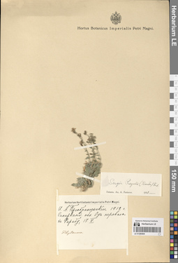
LE 01290532
Asyneuma campanuloides (M. Bieb. ex Sims) Bornm. det. Fedorov, Andrey Aleksandrovich at 1954
Administrative regions: GE - Georgia. Groups of specimens: Образцы сектора Кавказа; Соглашение Минобрнауки №075-15-2021-1056Original label text:манглис, Тифлисская губерния.
Coordinates (geographic position): 41° 40′ 40.97″ N, 44° 15′ 6.81″ EComment: Верхняя часть восточного склона Желтой горы.
Georgia, Manglisi, the upper part of the eastern slope of the Zhyeltaya mount.
Record creation: 2024-08-04, Daria Yudova, PhotoScan D2.Citation: Specimen LE 01290532 // Virtual herbarium of Komarov Botanical Institute RAS — http://re.herbariumle.ru/01290532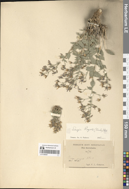
LE 01290401
Sergia regelii (Trautv.) Fed. det. Fedorov, Andrey Aleksandrovich at 1954
Collectors: Komarov, Vladimir Leontjevich Collection date: 14.06.1892. Administrative regions: TJ - Tajikistan. Groups of specimens: Образцы сектора Средней АзииOriginal label text:Prope pagum Artucz.
Coordinates (geographic position): 39° 20′ 10.56″ N, 68° 6′ 56.52″ ERecord creation: 2024-08-04, Daria Yudova, PhotoScan D2.Citation: Specimen LE 01290401 // Virtual herbarium of Komarov Botanical Institute RAS — http://re.herbariumle.ru/0129040114.VI.1892
V. L. Komarov
LE 01290531
Asyneuma campanuloides (M. Bieb. ex Sims) Bornm. det. Menitsky, Yuri Leonardovich
Collection date: 25.08.1970. Administrative regions: GE - Georgia. Groups of specimens: Образцы сектора Кавказа; Соглашение Минобрнауки №075-15-2021-1056Original label text:Грузия: Казбеги. Близ села Сноу [= Сно].
Coordinates (geographic position): 42° 36′ 43.76″ N, 44° 38′ 33.59″ EComment: 25.VIII.70
В. Чунов
Georgia: Kazbegi. The Sno village.
Record creation: 2024-08-04, Daria Yudova, PhotoScan D2.Citation: Specimen LE 01290531 // Virtual herbarium of Komarov Botanical Institute RAS — http://re.herbariumle.ru/0129053125.08.1970
Coll. V. Chunov
LE 01290400
Sergia regelii (Trautv.) Fed. det. Fedorov, Andrey Aleksandrovich at 1954
Collectors: Regel, (Johann) Albert von Collection date: 31.08.1884. Administrative regions: TJ - Tajikistan. Groups of specimens: Образцы сектора Средней АзииOriginal label text:Sarawschan: in mont. Artutsch pr. Kschtut.
Coordinates (geographic position): 39° 20′ 10.56″ N, 68° 6′ 56.52″ ERecord creation: 2024-08-04, Daria Yudova, PhotoScan D2.Citation: Specimen LE 01290400 // Virtual herbarium of Komarov Botanical Institute RAS — http://re.herbariumle.ru/012904005 - 6000'
14 - 31.VIII.1884
LE 01290530
Asyneuma campanuloides (M. Bieb. ex Sims) Bornm. det. Husseinov, Sch. A.
Collectors: Husseinov, Sch. A. Collection date: 03.07.1968. Administrative regions: RU - Dagestan - Akushinskiy Rayon. Groups of specimens: Образцы сектора Кавказа; Соглашение Минобрнауки №075-15-2021-1056Original label text:Село Бутри + ["шарубала бек"]
Coordinates (geographic position): 42° 10′ 55.16″ N, 47° 25′ 55.39″ EComment: Северный склон, на лугах, субальпийский пояс.
3.7.68 год
Leg. Гусейнов
Dagestan, Akushinskiy district, the Butri village. Northern slope, in meadows, subalpine zone.
Record creation: 2024-08-04, Daria Yudova, PhotoScan D2.Citation: Specimen LE 01290530 // Virtual herbarium of Komarov Botanical Institute RAS — http://re.herbariumle.ru/012905303.07.1968
Coll. Husseinov
LE 01290399
Sergia regelii (Trautv.) Fed.
Collectors: Kamelin, Rudolph Vladimirovich Collection date: 07.1965. Administrative regions: TJ - Tajikistan. Groups of specimens: Образцы сектора Средней АзииOriginal label text:Таджикистан, Фанские горы, окрестности озера Кули-Калон, скалы выше озера, 2700 и выше.
Coordinates (geographic position): 39° 14′ 55.24″ N, 68° 10′ 3.15″ E 2700 m a.s.l.Comment: 1965-VII
Р. Камелин
Tajikistan, Fan Mountains, surroundings of Lake Kuli-Kalon, rocks above the lake, 2700 m and above.
Record creation: 2024-08-04, Daria Yudova, PhotoScan D2.Citation: Specimen LE 01290399 // Virtual herbarium of Komarov Botanical Institute RAS — http://re.herbariumle.ru/0129039907.1965
R. Kamelin