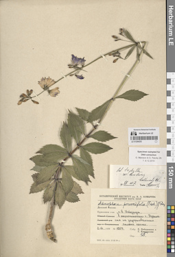
View
Add
Copy
Edit
Delete
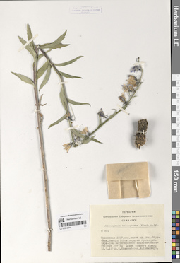
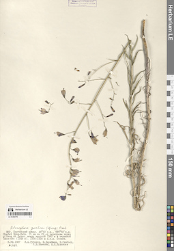
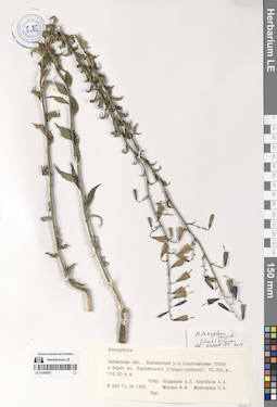
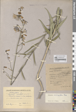
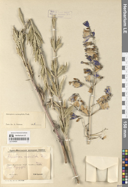
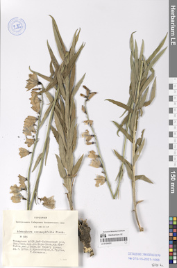
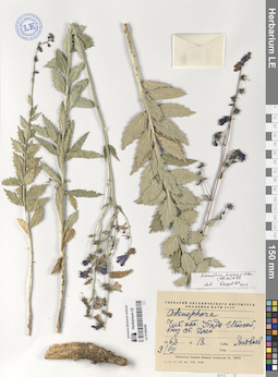
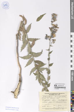
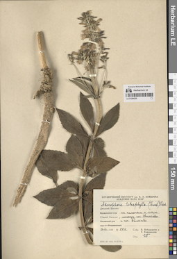
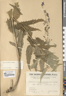
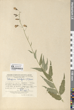
LE 01294274
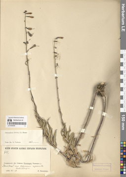
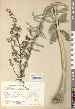
Adenophora tricuspidata (Fisch. ex Roem. & Schult.) A. DC.
Collectors: Krasnoborov, Ivan Moiseevich; Khanminchun, Valerij Mikhailovich Field collecting number: 882. Collection date: 15.07.1974. Administrative regions: RU - Respublika Tyva. Groups of specimens: Образцы сектора Сибири и Дальнего Востока РоссииOriginal label text:№ 882
Coordinates (geographic position): 52° 0′ 8.33″ N, 95° 15′ 44.17″ EComment: Тувинская ААСР, западный склон хребта Академика Обручева, бассейн реки Тапса, верхний ее правый приток Кара-Хем.Закустаренный злаково-разнотравный луг на месте бывшего жилья.
15.7.1974
И. Красноборов, В. Ханминчун
№ 882
Record creation: 2024-08-10, Daria Yudova, PhotoScan D2.Citation: Specimen LE 01294274 // Virtual herbarium of Komarov Botanical Institute RAS — http://re.herbariumle.ru/01294274Republic of Tyva, Western slope of the Academician Obruchev ridge, the Tapsa River basin, its upper right tributary Kara-Khem. A bushy grass-forb meadow on the site of a former dwelling.
15.07.1974
Coll. I. Krasnoborov, V. Khanminchun
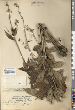
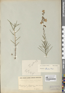
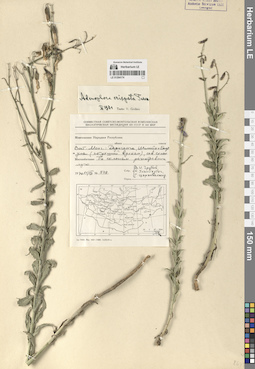
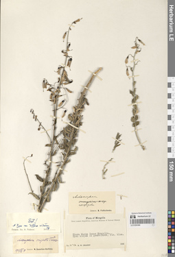
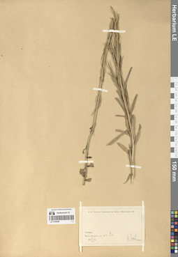
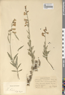
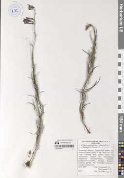
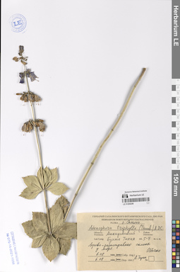
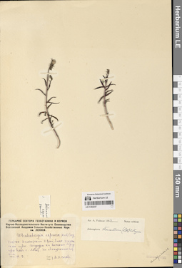
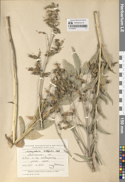
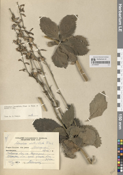
LE 01294273
Adenophora tetraphylla (Thunb.) Fisch. det. Fedorov, Andrey Aleksandrovich at 1965
Collection date: 19.07.1956. Administrative regions: RU - Zabaykal'skiy Kray. Groups of specimens: Образцы сектора Сибири и Дальнего Востока РоссииOriginal label text:Читинская область. Нерчинско-заводской район. Северный склон сопки у водораздела падей Грязной и Сенной близ Нерчинского завода.
Coordinates (geographic position): 51° 17′ 4.28″ N, 119° 39′ 51.03″ EComment: 19.VII.1956
Р. Т. Яцурина
Chita region. Nerchinsko-zavodskoy district. Northern slope of the hill at the watershed of the Gryaznaya and Sennaya gorges near the Nerchinsky Zavod.
19.07.1956
Coll. R. T. Yatsurina
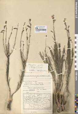
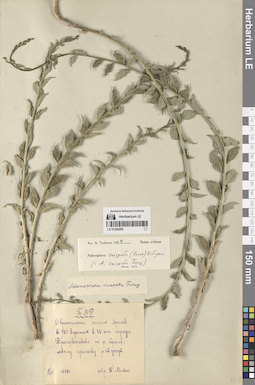
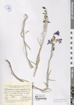
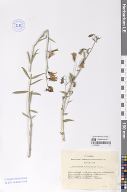
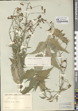
LE 01294177
Adenophora gmelinii (Spreng.) Fisch.
Collectors: Potanin, Grigorii Nikolajevic; Soldatov, V.V. Collection date: 05.07.1899. Administrative regions: CN - China. Groups of specimens: Образцы сектора Центральной и Восточной Азии; Соглашение Минобрнауки №075-15-2021-1056Original label text:Кулун-буир-[...]орская равнина.
Coordinates (geographic position): 46° 4′ 17.25″ N, 118° 45′ 21.75″ EComment: Между рекой Ульгин-гол и озером Лыксэ.
5 июля 1899 г.
Собрали Потанин и Солдатов.
Khulun-buir-[...] plain.
Record creation: 2024-08-09, Daria Yudova, PhotoScan D2.Citation: Specimen LE 01294177 // Virtual herbarium of Komarov Botanical Institute RAS — http://re.herbariumle.ru/01294177Between the Ulgin-gol River and Lake Lykse.
5.07.1899
Coll. G. Potanin, V. Soldatov
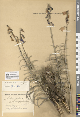
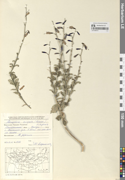
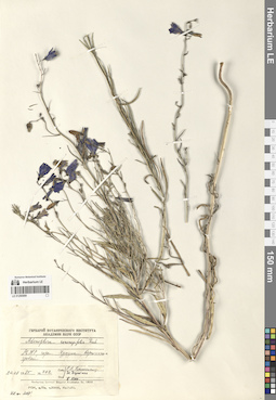
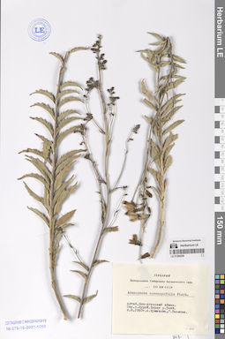
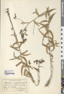
LE 01294270
Adenophora gmelinii (Spreng.) Fisch. det. Knjazev, Mikhail Sergeyevich at 2019
Collectors: Budantsev, Andrey Lvovich; Korobkov, Aleksandr Aleksandrovich; Mokhova, I.I.; Medvedeva, Nina Anatolyevna Field collecting number: 59. Collection date: 03.08.1995. Administrative regions: RU - Zabaykal'skiy Kray. Groups of specimens: Образцы сектора Сибири и Дальнего Востока РоссииOriginal label text:Читинская область, Агинский-Бурятский АО, долина реки Ага, каменистые склоны к югу от села Ага, 51,10 с.ш., 115,10 в.д.
Coordinates (geographic position): 51° 10′ 21.9″ N, 115° 11′ 22.22″ EComment: № 59
3.08.1995
Буданцев А. Л., Коробков А. А., Мохова И. И., Медведева Н. А.
Chita region, Aginsky-Buryat Autonomous Okrug, Aga River valley, rocky slopes to the south of the village of Aga, 51.10 N, 115.10 E.
№ 59
3.08.1995
Coll. Budantsev A.L., Korobkov A.A., Mokhova I.I., Medvedeva N.A.
LE 01294176
Adenophora gmelinii (Spreng.) Fisch.
Collectors: Gubanov, Ivan Alekseevich; Darijma, Sh.; Ganbold, E.; Kamelin, Rudolph Vladimirovich; Budantsev, Andrey Lvovich Field collecting number: 2488. Collection date: 03.08.1987. Administrative regions: MN - Mongolia. Groups of specimens: Образцы сектора Центральной и Восточной Азии; Соглашение Минобрнауки №075-15-2021-1056Original label text:МНР. Хэнтэйский аймак. 48° 50' с.ш. 111° 50' в.д. Хребет Эрэн-Даба. 15 км на СВ от переправы через реку Онон на Дадал, между высотой 1360 м и вершиной Олон-Обо (1348 м). 1300-1320 м н.у.м. Сосняк.
Coordinates (geographic position): 48° 50′ 0″ N, 111° 50′ 0″ EComment: № 2488
3.VIII.1987
И. А. Губанов, Ш. Дариймаа, Э. Ганболд, Р. В. Камелин, А. Л. Буданцев
Mongolia. Khentei aimag. 48° 50' N 111° 50'E Eren-Daba Ridge. 15 km to the NE from the crossing of the Onon River to Dadal, between an altitude of 1360 m and the peak of Olon-Obo (1348 m). 1300-1320 m above sea level Pine forest.
Record creation: 2024-08-09, Daria Yudova, PhotoScan D2.Citation: Specimen LE 01294176 // Virtual herbarium of Komarov Botanical Institute RAS — http://re.herbariumle.ru/01294176№ 2488
3.08.1987
Coll. I. A. Gubanov, Sh. Darijma, E. Ganbold, R. V. Kamelin, A. L. Budantsev
LE 01294269
Adenophora gmelinii (Spreng.) Fisch. det. Fedorov, Andrey Aleksandrovich at 1954
Collectors: Arndt, P. Collection date: 07.06.1910. Administrative regions: RU - Zabaykal'skiy Kray - Khilokskiy Rayon. Groups of specimens: Образцы сектора Сибири и Дальнего Востока РоссииOriginal label text:Забайкальская область. Верхнеудинский уезд. Лево-Хилокская лесная дача. Деревня Блудная [= Хилогосон?]. Бор.
Coordinates (geographic position): 51° 9′ 1.84″ N, 110° 38′ 23.65″ EComment: 7.VI.1910
П. Арндт
Transbaikal region. Verkhneudinsk district. Levo-Khilok forest dacha. Village Bludnaya [= Khilogoson?]. Bor.
Record creation: 2024-08-10, Daria Yudova, PhotoScan D2.Citation: Specimen LE 01294269 // Virtual herbarium of Komarov Botanical Institute RAS — http://re.herbariumle.ru/012942697.06.1910
Coll. P. Arndt
LE 01294175
Adenophora gmelinii (Spreng.) Fisch. det. Krestovskaya, Tatiana Valerievna at 2001
Collectors: Yunatov, Alexander Afanasievich Field collecting number: 16303. Collection date: 06.08.1949. Administrative regions: MN - Mongolia. Groups of specimens: Образцы сектора Центральной и Восточной Азии; Соглашение Минобрнауки №075-15-2021-1056Original label text:Монгольская Народная Республика.
Comment: Восточный аймак, Хунту сомон.
В 30 км к ВЮВ от Баин-Цаган. Ковыльно-разнотравная степь.
№ 16303
6.VIII.1949
А. А. Юнатов
Mongolia. Eastern aimag, Khuntu somon.
30 km to the east-southeast of Bain-Tsagan. Feather-grass and mixed-grass steppe.№ 16303
6.08.1949
Coll. A. A. Yunatov
LE 01294268
Adenophora gmelinii (Spreng.) Fisch. det. Fedorov, Andrey Aleksandrovich at 1954
Collectors: Kononov, S.S. Collection date: 10.06.1910. Administrative regions: RU - Krasnoyarskiy Kray. Groups of specimens: Образцы сектора Сибири и Дальнего Востока РоссииOriginal label text:Окрестности Красноярска, Базайха. Гора Диван.
Coordinates (geographic position): 55° 58′ 23.13″ N, 92° 48′ 42.5″ EComment: 10.VI.1910
С. С. Кононов
The environs of Krasnoyarsk, Bazaikha. Mount Divan.
Record creation: 2024-08-10, Daria Yudova, PhotoScan D2.Citation: Specimen LE 01294268 // Virtual herbarium of Komarov Botanical Institute RAS — http://re.herbariumle.ru/0129426810.06.1910
Coll. S.S. Kononov
LE 01294267
Adenophora crispata (Turcz. ex Kitag.) Kitag. det. Knjazev, Mikhail Sergeyevich at 2019
Collectors: Budantsev, Andrey Lvovich; Korobkov, Aleksandr Aleksandrovich; Mokhova, I.I.; Medvedeva, Nina Anatolyevna Field collecting number: 226. Collection date: 10.08.1995. Administrative regions: RU - Zabaykal'skiy Kray - Borzinskiy Rayon. Groups of specimens: Образцы сектора Сибири и Дальнего Востока РоссииOriginal label text:Читинская область, Борзинский район, солончаковые степи и берег озера Борзинского (горько-соленое). 50,20 с.ш., 116,20 в.д.
Coordinates (geographic position): 50° 14′ 50.43″ N, 116° 16′ 30.14″ EComment: № 226
10.08.1995
Буданцев А. Л., Коробков А. А., Мохова И. И., Медведева Н. А.
Chita region, Borzinsky district, salt marsh steppes and the shore of Lake Borzinskoye (bitter-salty). 50.20 N, 116.20 E.
Record creation: 2024-08-10, Daria Yudova, PhotoScan D2.Citation: Specimen LE 01294267 // Virtual herbarium of Komarov Botanical Institute RAS — http://re.herbariumle.ru/01294267№ 226
10.08.1995
Coll. A. L. Budantsev, A. A. Korobkov, I. I. Mokhova, N. A. Medvedeva
LE 01294174
Adenophora crispata (Turcz. ex Kitag.) Kitag.
Collectors: Grubov, Valery Ivanovich; Ulziykhutag, Nadmidyn; Tserenbalzhid, G. Field collecting number: 579. Collection date: 11.08.1970. Administrative regions: MN - Mongolia. Groups of specimens: Образцы сектора Центральной и Восточной Азии; Соглашение Минобрнауки №075-15-2021-1056Original label text:Восточная Монголия: Дариганга, Шилийн-Богдо-ула (потухший вулкан), северный склон. По склонам разнотравные луга.
Coordinates (geographic position): 45° 28′ 17″ N, 114° 35′ 2″ EComment: № 579
11.VIII.1970
В. И. Грубов, Н. Улзийхутаг, Г. Цэрэнбалжид
Eastern Mongolia: Dariganga, Shiliin-Bogdo-ula (extinct volcano), northern slope. Mixed grass meadows on the slopes.
Record creation: 2024-08-09, Daria Yudova, PhotoScan D2.Citation: Specimen LE 01294174 // Virtual herbarium of Komarov Botanical Institute RAS — http://re.herbariumle.ru/01294174№ 579
11.08.1970
Coll. V. I. Grubov, N. Ulziykhutag, G. Tserenbalzhid
LE 01294266
Adenophora crispata (Turcz. ex Kitag.) Kitag. det. Fedorov, Andrey Aleksandrovich at 1954
Collectors: Mikhno, Petr Savvich Collection date: 06.07.1928. Administrative regions: RU - Respublika Buryatiya. Groups of specimens: Образцы сектора Сибири и Дальнего Востока РоссииOriginal label text:Окрестности селения Армак в 180 верстах к W от города Троицкосавска по реке Армак, левому притоку реки Джиды.
Coordinates (geographic position): 50° 36′ 34.6″ N, 104° 36′ 45.64″ EComment: 6.VII.1928
П. Михно
The outskirts of the village of Armak, 180 miles to the west of the city of Troitskosavsk along the Armak River, a left tributary of the Dzhida River.
Record creation: 2024-08-10, Daria Yudova, PhotoScan D2.Citation: Specimen LE 01294266 // Virtual herbarium of Komarov Botanical Institute RAS — http://re.herbariumle.ru/012942666.07.1928
Coll. P. Mikhno
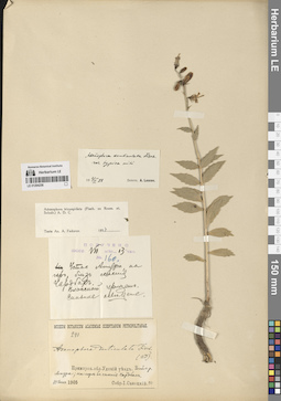
LE 01294173
Adenophora crispata (Turcz. ex Kitag.) Kitag.
Collectors: Darijma, Sh. Field collecting number: 575. Collection date: 05.07.1974. Administrative regions: MN - Mongolia. Groups of specimens: Образцы сектора Центральной и Восточной Азии; Соглашение Минобрнауки №075-15-2021-1056Original label text:Монгольская Народная Республика. Центральный аймак, сомон Унжул. Гора Баянгийн-ула, в 10 км на юго-восток от сомона. В зарослях.
Comment: № 575
5.VII.1974
Ш. Дарийма
Mongolia. Central aimag, Unjul sum. Mount Bayangiin-ula, 10 km southeast of the sum.
Record creation: 2024-08-09, Daria Yudova, PhotoScan D2.Citation: Specimen LE 01294173 // Virtual herbarium of Komarov Botanical Institute RAS — http://re.herbariumle.ru/01294173№ 575
5.07.1974
Coll. Sh. Darijma
LE 01294265
Adenophora coronopifolia Fisch. det. Fedorov, Andrey Aleksandrovich at 1956
Collection date: 27.07.1939. Groups of specimens: Образцы сектора Сибири и Дальнего Востока РоссииOriginal label text:Якутская АССР. Ленский район. Долина реки Лены у деревни Федоровой. Опушка леса, луг.
Coordinates (geographic position): 59° 28′ 6.98″ N, 117° 4′ 7.83″ EComment: 27.VII.1939
Чеидзе Г.
Yakutia. Lensky district. Lena river valley near Fedorova village. Forest edge, meadow.
Record creation: 2024-08-10, Daria Yudova, PhotoScan D2.Citation: Specimen LE 01294265 // Virtual herbarium of Komarov Botanical Institute RAS — http://re.herbariumle.ru/0129426527.07.1939
Coll. Cheidze G.
[The village of Fedorovo is located in the Irkutsk region]
LE 01291000
Adenophora crispata (Turcz. ex Kitag.) Kitag.
Field collecting number: 472. Collection date: 1925. Administrative regions: MN - Mongolia. Groups of specimens: Образцы сектора Центральной и Восточной Азии; Соглашение Минобрнауки №075-15-2021-1056Original label text:Shara Murun Inner Mongolia.
Record creation: 2024-08-09, Daria Yudova, PhotoScan D2.Citation: Specimen LE 01291000 // Virtual herbarium of Komarov Botanical Institute RAS — http://re.herbariumle.ru/01291000Open slopes in grasslands, Fls. blue.
№ 472
1925
Coll. R. W. Chaney
LE 01294264
Adenophora coronopifolia Fisch.
Collectors: Isachenko, T.I. Field collecting number: 178. Collection date: 25.07.1963. Administrative regions: RU - Zabaykal'skiy Kray - Borzinskiy Rayon. Groups of specimens: Образцы сектора Сибири и Дальнего Востока РоссииOriginal label text:Читинская область. Борзинский район. В 28 км к ЮЗ от Армогайтуя. В луговой пади у ущелья.
Comment: № 178
25.VII.1963
Т. И. Исаченко
Chita region. Borzinsky district. 28 km to the southwest from Armogaituy. In a meadow hollow near a gorge.
№ 178
25.07.1963
Coll. T.I. Isachenko
LE 01290999
Adenophora coronopifolia Fisch. det. Kamelin, Rudolph Vladimirovich
Collectors: Kamelin, Rudolph Vladimirovich; Darijma, Sh. Field collecting number: 792. Collection date: 24.08.1985. Administrative regions: MN - Mongolia. Groups of specimens: Образцы сектора Центральной и Восточной Азии; Соглашение Минобрнауки №075-15-2021-1056Original label text:МНР, горы Хухула, вершинные гребни.
Comment: № 792
24.08.1985
Р. В. Камелин, Ш. Дариймаа
Mongolia, Huhula Mountains, summit ridges.
№ 792
24.08.1985
Coll. R. V. Kamelin, Sh. Darijma
LE 01294263
Adenophora coronopifolia Fisch. det. Fedorov, Andrey Aleksandrovich at 1956
Collectors: Kurskiy, P.I. Collection date: 07.08.1934. Administrative regions: RU - Respublika Buryatiya - Dzhidinskiy Rayon. Groups of specimens: Образцы сектора Сибири и Дальнего Востока РоссииOriginal label text:Бурято-Монгольская АССР. Бассейн реки Джиды. Падь Подхулдай.
Coordinates (geographic position): 50° 32′ 3.34″ N, 104° 42′ 30.81″ EComment: 7.VIII.1934
П. И. Курский
Republic of Buryatia. Dzhida River basin. Podkhuldai valley.
7.08.1934
Coll. P.I. Kurskiy
LE 01290998
Adenophora coronopifolia Fisch.
Collectors: Lipsky, Vladimir Ippolitovich Collection date: 09.07.1901. Administrative regions: CN - China. Expedition: В.И. Липский, Путешествие в Сибирь и Маньчжурию 1901 (1901)Groups of specimens: Образцы сектора Центральной и Восточной Азии; Соглашение Минобрнауки №075-15-2021-1056Original label text:В.И. Липский, Путешествие в Сибирь и Маньчжурию 1901
Coordinates (geographic position): 48° 32′ 44.91″ N, 122° 8′ 11.54″ EComment: Манчжурия, станция ж.д. Ял.
9.VII.1901
В. Липский
V.I. Lipsky, Journey to Siberia and Manchuria 1901
Record creation: 2024-08-09, Daria Yudova, PhotoScan D2.Citation: Specimen LE 01290998 // Virtual herbarium of Komarov Botanical Institute RAS — http://re.herbariumle.ru/01290998Manchuria, Yal railway station.
9.07.1901
Coll. V. Lipsky
LE 01294262
Adenophora coronopifolia Fisch. det. Fedorov, Andrey Aleksandrovich
Collectors: Ganeschin, Sergej Sergejewitsch Field collecting number: 552. Collection date: 14.07.1909. Expedition: С.С. Ганешин: Ангаро-Илимская экспедиция, Иркутской губ. 1909 г. (1909)Groups of specimens: Образцы сектора Сибири и Дальнего Востока РоссииOriginal label text:С.С. Ганешин: Ангаро-Илимская экспедиция, Иркутской губ. 1909 г.
Coordinates (geographic position): 54° 28′ 44.92″ N, 103° 16′ 20.56″ EComment: Иркутская губерния, Балаганский уезд
Луг близ деревни Милославской
14.VII.
S.S. Ganeshin: Angara-Ilimsk expedition, Irkutsk province. 1909
Record creation: 2024-08-10, Daria Yudova, PhotoScan D2.Citation: Specimen LE 01294262 // Virtual herbarium of Komarov Botanical Institute RAS — http://re.herbariumle.ru/01294262Irkutsk province, Balagansky district Meadow near the village of Miloslavskaya
14.07.1909
Coll. S.S. Ganeshin
LE 01290997
Adenophora coronopifolia Fisch. det. Grubov, Valery Ivanovich at 23.12.1957
Collectors: Ivashkevich, B.A. Field collecting number: 217. Collection date: 19.07.1909. Administrative regions: CN - China. Groups of specimens: Образцы сектора Центральной и Восточной Азии; Соглашение Минобрнауки №075-15-2021-1056Original label text:Манчжурия. Провинция Хейлундзянская. Большой Хинган. Станция Барим. Заливной луг в долине реки Яла.
Coordinates (geographic position): 48° 19′ 17.3″ N, 122° 19′ 7.2″ EComment: 19.VII.1909
Собр. Б. А. Ивашкевич
Manchuria. Heilongjiang Province. Greater Khingan. Barim Station. Flood meadow in the Yalu River valley.
Record creation: 2024-08-09, Daria Yudova, PhotoScan D2.Citation: Specimen LE 01290997 // Virtual herbarium of Komarov Botanical Institute RAS — http://re.herbariumle.ru/0129099719.07.1909
Coll. B. A. Ivashkevich
LE 01294261
Adenophora coronopifolia Fisch.
Collectors: Krasnoborov, Ivan Moiseevich; Grubov, Valery Ivanovich; Yakovleva, G. Field collecting number: 585. Collection date: 24.07.1976. Administrative regions: RU - Respublika Tyva. Groups of specimens: Образцы сектора Сибири и Дальнего Востока РоссииOriginal label text:№ 585
Coordinates (geographic position): 51° 23′ 47.18″ N, 89° 17′ 57.75″ EComment: Тувинская АССР, Бай-Тайгинский район, Западный Саян, окрестности озера Кара-Холь, хребет Ери-Тайга, высота 1460 м. По берегу ручья.
24.7.1976
И. Красноборов, В. Грубов, Г. Яковлева
№ 585
Record creation: 2024-08-10, Daria Yudova, PhotoScan D2.Citation: Specimen LE 01294261 // Virtual herbarium of Komarov Botanical Institute RAS — http://re.herbariumle.ru/01294261Republic of Tyva, Bai-Taiginsky district, Western Sayan, vicinity of Lake Kara-Khol, Eri-Taiga ridge, altitude 1460 m. Along the bank of a stream.
24.07.1976
Coll. I. Krasnoborov, V. Grubov, G. Yakovleva
LE 01290996
Adenophora coronopifolia Fisch.
Collectors: Putjata Collection date: 22.07.1891. Administrative regions: CN - China. Groups of specimens: Образцы сектора Центральной и Восточной Азии; Соглашение Минобрнауки №075-15-2021-1056Original label text:China borealis, Chihli Tung kia ying tze frequens.
Record creation: 2024-08-09, Daria Yudova, PhotoScan D2.Citation: Specimen LE 01290996 // Virtual herbarium of Komarov Botanical Institute RAS — http://re.herbariumle.ru/0129099622 Julio 1891
Leg. Putjata
LE 01294260
Adenophora coronopifolia Fisch.
Collectors: Neyfeld, I.; Dereka, G. Collection date: 30.06.1968. Administrative regions: RU - Respublika Khakasiya. Groups of specimens: Образцы сектора Сибири и Дальнего Востока РоссииOriginal label text:Красноярский край, Хакасия, Усть-Абаканский район, окрестности села Москва, хутор Прилуцкого. Лиственнично-березовый лес.
Coordinates (geographic position): 53° 55′ 49.77″ N, 91° 6′ 18.25″ EComment: 30.6.1968
И. Нейфельд, Г. Дерека
Krasnoyarsk region, Khakassia, Ust-Abakansky district, outskirts of the village of Moscow, Prilutsky farm. Larch-birch forest.
Record creation: 2024-08-10, Daria Yudova, PhotoScan D2.Citation: Specimen LE 01294260 // Virtual herbarium of Komarov Botanical Institute RAS — http://re.herbariumle.ru/0129426030.06.1968
Coll. I. Neyfeld, G. Dereka
LE 01294259
Adenophora coronopifolia Fisch.
Collectors: Kuminova, Alexandra Vladimirovna; Pavlova, G. Collection date: 04.08.1950. Administrative regions: RU - Respublika Altay - Kosh-Agachskiy Rayon. Groups of specimens: Образцы сектора Сибири и Дальнего Востока РоссииOriginal label text:Алтай, Кош-Агачский аймак. Окрестности села Курай. Берег реки Тетё.
Coordinates (geographic position): 50° 12′ 0.55″ N, 87° 54′ 17″ EComment: 4.8.1950
А. Куминова, Г. Павлова
Altai, Kosh-Agach aimak. The outskirts of the village of Kurai. Bank of the Tetyo River.
4.08.1950
Coll. A. Kuminova, G. Pavlova
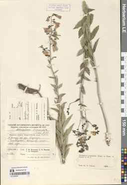
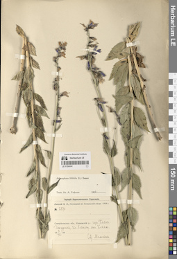
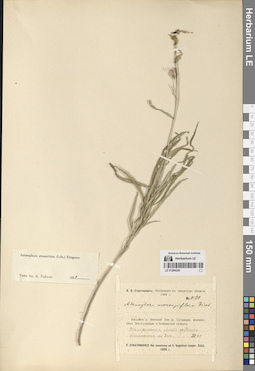
LE 01294258
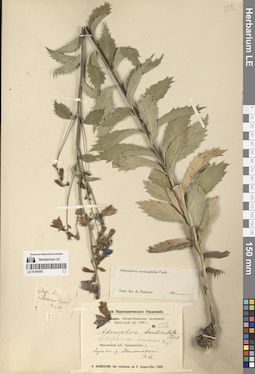
Adenophora tricuspidata (Fisch. ex Roem. & Schult.) A. DC. det. Knjazev, Mikhail Sergeyevich at 2019
Field collecting number: 18. Collection date: 09.08.1963. Administrative regions: RU - Zabaykal'skiy Kray. Groups of specimens: Образцы сектора Сибири и Дальнего Востока РоссииOriginal label text:Читинская область. Падь Итылей, близ станции Улей.
Coordinates (geographic position): 52° 37′ 8.14″ N, 117° 10′ 22.54″ EComment: № 18
9.VIII.1963
Яновлев
Chita region. Ityley valley, near Uley station.
№ 18
9.08.1963
Coll. Yanovlev
LE 01294257
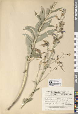
Adenophora gmelinii (Spreng.) Fisch. det. Golovina, Ekaterina Olegovna
Collectors: Golovina, Ekaterina Olegovna; Imetkhenova, O.V. Field collecting number: 93. Collection date: 23.07.2005. Administrative regions: RU - Zabaykal'skiy Kray. Groups of specimens: Образцы сектора Сибири и Дальнего Востока РоссииOriginal label text:Читинская область. Кыринский район. Заказник "Горная степь" 19 км к ЮЮЗ от поселка Кыра. Средняя часть склона сопки СВ экспозиции, наклон 20°. Разнотравно (Bupleurum scorzonerifolium, Pulsatilla turchaninovii)-злаково (Festuca lenensis, Koeleria gracilis, Poa botryoides)-нитилистниковое сообщество.
Coordinates (geographic position): 49° 24′ 10.17″ N, 111° 56′ 57.49″ EComment: № 93
23.07.2005
Головина Е. О., Иметхенова О. В.
Chita Region. Kyra District. Nature Reserve "Mountain Steppe" 19 km SSW from the village of Kyra. Middle part of the slope of the hill of NE exposure, slope 20°. Forb (Bupleurum scorzonerifolium, Pulsatilla turchaninovii)-grass (Festuca lenensis, Koeleria gracilis, Poa botryoides)-filamentous community.
Record creation: 2024-08-10, Daria Yudova, PhotoScan D2.Citation: Specimen LE 01294257 // Virtual herbarium of Komarov Botanical Institute RAS — http://re.herbariumle.ru/01294257№ 93
23.07.2005
Coll. E. O. Golovina, O. V. Imetkhenova
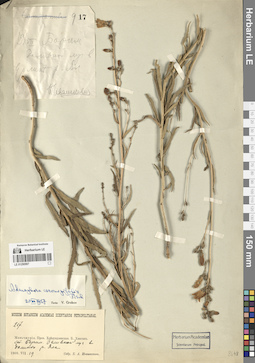
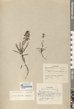
LE 01294256
Adenophora tricuspidata (Fisch. ex Roem. & Schult.) A. DC. det. Fedorov, Andrey Aleksandrovich at 1954
Collectors: Sanotsky, Joseph Genrikhovich Field collecting number: 160. Collection date: 13.07.1905. Administrative regions: RU - Khabarovskiy Kray. Groups of specimens: Образцы сектора Сибири и Дальнего Востока РоссииOriginal label text:1) № 160
Coordinates (geographic position): 53° 0′ 49.1″ N, 141° 11′ 8.1″ EComment: 13.VII.1905
Устье Амура, на горе, близ селения Чардбах. Влажный чернозем. [Сильное освещение]
2) 241
Приморская область. Удский уезд. Устье реки Амура; на горе близ селения Чардбах.
13 июля 1905
Собр. I. Саноцкiй
1) № 160
13.VII.1905
Record creation: 2024-08-10, Daria Yudova, PhotoScan D2.Citation: Specimen LE 01294256 // Virtual herbarium of Komarov Botanical Institute RAS — http://re.herbariumle.ru/0129425613.VII.1905
The mouth of the Amur, on a mountain, near the village of Chardbakh. Wet black soil.
2) 241
Primorsky region. Udsky district. The mouth of the Amur River; on a mountain near the village of Chardbakh.
13.07.1905
Coll. I. Sanotsky
LE 01294255
Adenophora tricuspidata (Fisch. ex Roem. & Schult.) A. DC. det. Fedorov, Andrey Aleksandrovich at 1960
Collectors: Isachenko, T.I.; Pivnik, S.A.; Samarina G.D. Field collecting number: 399. Collection date: 13.08.1958. Administrative regions: RU - Amurskaya Oblast' - Svobodnenskiy Rayon. Groups of specimens: Образцы сектора Сибири и Дальнего Востока РоссииOriginal label text:Амурская область. Амуро-Зейское плато, в 10 км к западу от деревни Глухари. Разнотравно-вейниково-осоковый луг.
Coordinates (geographic position): 51° 45′ 31.02″ N, 128° 15′ 54.61″ EComment: № 399
13.VIII.1958
Т. И. Исаченко, С. А. Пивник, Г. Д. Самарина
Amur Region. Amur-Zeiskoe plateau, 10 km west of the village of Glukhari.
Record creation: 2024-08-10, Daria Yudova, PhotoScan D2.Citation: Specimen LE 01294255 // Virtual herbarium of Komarov Botanical Institute RAS — http://re.herbariumle.ru/01294255№ 399
13.08.1958
Coll. T.I. Isachenko, S.A. Pivnik, G.D. Samarina
LE 01294254
Adenophora tricuspidata (Fisch. ex Roem. & Schult.) A. DC.
Collectors: Boiko, Elvira Vasiljevna; Starchenko, V.M. Collection date: 20.08.1980. Administrative regions: RU - Amurskaya Oblast' - Skovorodinskiy Rayon. Groups of specimens: Образцы сектора Сибири и Дальнего Востока РоссииOriginal label text:Амурская область, Сковородинский район, село Игнашино.
Coordinates (geographic position): 53° 27′ 43.5″ N, 122° 24′ 5.99″ EComment: 20.VIII.1980
Бойко, Старченко
Amur region, Skovorodinsky district, Ignashino village.
20.08.1980
Coll. Boiko, Starchenko
LE 01294253
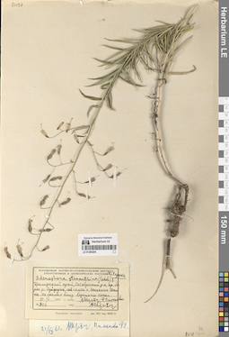
Adenophora triphylla (Thunb.) A. DC.
Collectors: Pobedimova, Evgeniia Georgievna; Konovalova, G. Field collecting number: 1209. Collection date: 02.08.1959. Administrative regions: RU - Sakhalinskaya Oblast'. Groups of specimens: Образцы сектора Сибири и Дальнего Востока РоссииOriginal label text:Дальний Восток: Курильские острова, остров Итуруп, в окрестности города Курильска на задернованном склоне сопки.
Coordinates (geographic position): 45° 13′ 54.83″ N, 147° 52′ 44.79″ EComment: № 1209
2.VIII.1959
Е. Победимова, Г. Коновалова
Far East: Kuril Islands, Iturup Island, in the vicinity of the city of Kurilsk on a grassy slope of a hill.
Record creation: 2024-08-10, Daria Yudova, PhotoScan D2.Citation: Specimen LE 01294253 // Virtual herbarium of Komarov Botanical Institute RAS — http://re.herbariumle.ru/01294253№ 1209
2.08.1959
Coll. E. Pobedimova, G. Konovalova
LE 01294252
Adenophora triphylla (Thunb.) A. DC.
Collection date: 31.08.1929. Administrative regions: RU - Sakhalinskaya Oblast' - Yuzhno-Kurilsky District. Groups of specimens: Образцы сектора Сибири и Дальнего Востока РоссииOriginal label text:Kuriles: Isl. Shikotan, Horobetsu - Okkaibetsu.
Coordinates (geographic position): 43° 48′ 50.75″ N, 146° 42′ 11.23″ ERecord creation: 2024-08-10, Daria Yudova, PhotoScan D2.Citation: Specimen LE 01294252 // Virtual herbarium of Komarov Botanical Institute RAS — http://re.herbariumle.ru/01294252Aug. 31, 1929
K. Kondo
LE 01294251
Adenophora triphylla (Thunb.) A. DC. det. Krestovskaya, Tatiana Valerievna
Collectors: Krestovskaya, Tatiana Valerievna Collection date: 12.09.1984. Administrative regions: RU - Sakhalinskaya Oblast' - Yuzhno-Kurilsky District. Groups of specimens: Образцы сектора Сибири и Дальнего Востока РоссииOriginal label text:О. Кунашир, окрестности Южно-Курильска. Травянистый спуск к реке в центре.
Coordinates (geographic position): 44° 1′ 50.35″ N, 145° 51′ 21.42″ EComment: 12.09.1984
Т. В. Крестовская
Kunashir Island, the vicinity of Yuzhno-Kurilsk. Grassy descent to the river in the center.
Record creation: 2024-08-10, Daria Yudova, PhotoScan D2.Citation: Specimen LE 01294251 // Virtual herbarium of Komarov Botanical Institute RAS — http://re.herbariumle.ru/0129425112.09.1984
Coll. T. V. Krestovskaya
LE 01294250
Adenophora tetraphylla (Thunb.) Fisch.
Collectors: Pobedimova, Evgeniia Georgievna; Konovalova, G. Field collecting number: 1331. Collection date: 13.08.1959. Administrative regions: RU - Sakhalinskaya Oblast'. Groups of specimens: Образцы сектора Сибири и Дальнего Востока РоссииOriginal label text:Дальний Восток: Южный Сахалин, по склонам к морю, между поселком Хвостово и поселком Атласово.
Coordinates (geographic position): 46° 4′ 53.94″ N, 142° 11′ 5.69″ EComment: №1331
13.VIII.1959
Е. Победимова и Г. Коновалова
Far East: South Sakhalin, along the slopes to the sea, between the village of Khvostovo and the village of Atlasovo.
Record creation: 2024-08-10, Daria Yudova, PhotoScan D2.Citation: Specimen LE 01294250 // Virtual herbarium of Komarov Botanical Institute RAS — http://re.herbariumle.ru/01294250№ 1331
13.08.1959
Coll. E. Pobedimova, G. Konovalova
LE 01294249
Adenophora triphylla (Thunb.) A. DC.
Collectors: Taran, Alexander Alexandrovich Collection date: 06.08.2000. Administrative regions: RU - Sakhalinskaya Oblast'. Groups of specimens: Образцы сектора Сибири и Дальнего Востока РоссииOriginal label text:О. Сахалин, бухта Тихая. Лугово-разнотравные склоны у моря. Обычно. 5-7 m.s.m.
Coordinates (geographic position): 48° 0′ 47.68″ N, 142° 31′ 58.58″ EComment: 06.08.2000
А. Таран
Sakhalin Island, Tikhaya Bay. Meadow-forb slopes by the sea. Usually. 5-7 m.s.m.
Record creation: 2024-08-10, Daria Yudova, PhotoScan D2.Citation: Specimen LE 01294249 // Virtual herbarium of Komarov Botanical Institute RAS — http://re.herbariumle.ru/0129424906.08.2000
Coll. A. Taran
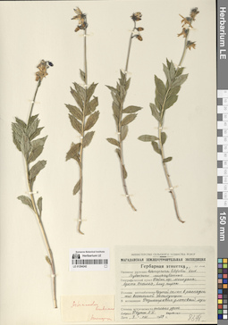
LE 01294343
Adenophora liliifolia (L.) A. DC. det. Fedorov, Andrey Aleksandrovich at 1954
Collectors: Killoman, I. Collection date: 31.07.1892. Groups of specimens: Образцы сектора Средней АзииOriginal label text:Семиреченская область. Окрестности города Верного.
Comment: 31.VII.1892
И. Килломан
Semirechensk region. The outskirts of the city of Verny.
Record creation: 2024-08-10, Daria Yudova, PhotoScan D2.Citation: Specimen LE 01294343 // Virtual herbarium of Komarov Botanical Institute RAS — http://re.herbariumle.ru/0129434331.07.1892
Coll. I. Killoman
LE 01294248
Adenophora tricuspidata (Fisch. ex Roem. & Schult.) A. DC.
Collectors: Pimenov, Michael Georgievich; Pimenova, Margarita E. Field collecting number: 98. Collection date: 22.07.1968. Administrative regions: RU - Amurskaya Oblast' - Bureyskiy Rayon. Groups of specimens: Образцы сектора Сибири и Дальнего Востока РоссииOriginal label text:Амурская область, Бурейский район, долина реки Буреи в окрестностях деревни Бахирево, левый берег Буреи близ Желунды.
Coordinates (geographic position): 50° 2′ 46.13″ N, 130° 1′ 26.77″ EComment: № 98
22.VII.1968
М. и Р. Пименовы
Amur region, Bureya district, Bureya river valley in the vicinity of the village of Bakhirevo, left bank of the Bureya near Zhelunda.
№ 98
22.07.1968
Coll. M. and R. Pimenov, Y. Stefanovich
LE 01294342
Adenophora liliifolia (L.) A. DC. det. Fedorov, Andrey Aleksandrovich at 1954
Collectors: Desjatkin, N. L. Collection date: 31.07.1928. Groups of specimens: Образцы сектора Средней АзииOriginal label text:Джаркентский уезд. Хоргоская волость. Отроги горного хребта Тянь-Шаня "Джунгарский Алатау".
Comment: Горы [Арасан], еловый лес.
31.VII.1928
Н. Л. Десяткин
Jarkent district. Khorgo volost. Spurs of the Tien Shan mountain range "Dzungarian Alatau". Mountains [Arasan], spruce forest.
31.07.1928
Coll. N. L. Desjatkin
LE 01294247
Adenophora stenanthina (Ledeb.) Kitag. det. Fedorov, Andrey Aleksandrovich at 1954
Collectors: Sochava, Viktor Borisovich Collection date: 09.09.1930. Administrative regions: RU - Kamtchatski Kray - Penzhinskiy Rayon. Groups of specimens: Образцы сектора Сибири и Дальнего Востока РоссииOriginal label text:Охотско-Камчатский край, бассейн Пенжинской губы. Тундра на высоком берегу губы близ села Ловат. По обнаженным пятнам.
Coordinates (geographic position): 62° 34′ 8.28″ N, 164° 45′ 44.76″ EComment: 1930.IX.9.
В. Б. Сочава
Kamtchatski Kray, Penzhinskaya Bay basin. Tundra on the high bank of the bay near the village of Lovat.
Record creation: 2024-08-10, Daria Yudova, PhotoScan D2.Citation: Specimen LE 01294247 // Virtual herbarium of Komarov Botanical Institute RAS — http://re.herbariumle.ru/012942479.09.1930
Coll. V. B. Sochava
LE 01294341
Adenophora liliifolia (L.) A. DC. det. Fedorov, Andrey Aleksandrovich at 1954
Collectors: Michelson, Alexander Ivanovich Field collecting number: 2870. Collection date: 03.07.1909. Administrative regions: KZ - Kazakhstan. Expedition: Липский В.И. Экспедиция в Копальский уезд 1909 г. (1909)Groups of specimens: Образцы сектора Средней АзииOriginal label text:Липский В.И. Экспедиция в Копальский уезд 1909 г.
Coordinates (geographic position): 45° 7′ 54.7″ N, 79° 17′ 1.3″ EComment: № 2870
Семиреченская область, Копальский уезд. Горы Баян-джурюн, к востоку от Копала.
3.VII.1909
Михельсон
Lipskiy V.I. Expedition to Kopalsky District 1909
Record creation: 2024-08-10, Daria Yudova, PhotoScan D2.Citation: Specimen LE 01294341 // Virtual herbarium of Komarov Botanical Institute RAS — http://re.herbariumle.ru/01294341№ 2870
Semirechensk Region, Kopalsky District. Bayan-Dzhurun Mountains, to the east of Kopal.
3.07.1909
Coll. Michelson
LE 01294246
Adenophora stenanthina (Ledeb.) Kitag. det. Fedorov, Andrey Aleksandrovich at 1954
Collectors: V. Rozenberg Field collecting number: 35. Collection date: 29.07.1952. Administrative regions: RU - Khabarovskiy Kray. Groups of specimens: Образцы сектора Сибири и Дальнего Востока РоссииOriginal label text:Хабаровский край, Охотский район, бассейн реки Улья, водораздел между рекой Улья и рекой Девокша.
Coordinates (geographic position): 58° 56′ 22.36″ N, 140° 39′ 30.34″ EComment: № 35.
29.VII.1952
Собрал В. Розенберг
Khabarovsk Krai, Okhotsk District, Ulya River basin, watershed between the Ulya River and the Devoksha River.
Record creation: 2024-08-10, Daria Yudova, PhotoScan D2.Citation: Specimen LE 01294246 // Virtual herbarium of Komarov Botanical Institute RAS — http://re.herbariumle.ru/01294246№ 35.
29.07.1952
Coll. V. Rozenberg
LE 01294340
Adenophora liliifolia (L.) A. DC. det. Fedorov, Andrey Aleksandrovich at 1954
Collectors: Rjeznitschenko, V.V. Field collecting number: 44. Collection date: 11.06.1899. Administrative regions: KZ - Pavlodar Oblysy. Groups of specimens: Образцы сектора Средней АзииOriginal label text:Семипалатинская область. Павлодарский уезд. Заливной луг Иртыша против Павлодара.
Coordinates (geographic position): 52° 17′ 5.58″ N, 76° 54′ 4.38″ EComment: 11.VI.1899
В. Резниченко
Semipalatinsk region. Pavlodar district. Irtysh floodplain opposite Pavlodar.
Record creation: 2024-08-10, Daria Yudova, PhotoScan D2.Citation: Specimen LE 01294340 // Virtual herbarium of Komarov Botanical Institute RAS — http://re.herbariumle.ru/0129434011.06.1899
Coll. V. Rjeznitschenko
LE 01294245
Adenophora stenanthina (Ledeb.) Kitag. det. Fedorov, Andrey Aleksandrovich at 1954
Collectors: V. V. Stratonovich Field collecting number: Д28. Collection date: 28.06.1909. Administrative regions: RU - Amurskaya Oblast' - Zeyskiy Rayon. Groups of specimens: Образцы сектора Сибири и Дальнего Востока РоссииOriginal label text:В. В. Стратонович: Экспедиция в Амурскую область 1909 г.
Coordinates (geographic position): 54° 42′ 47.33″ N, 128° 51′ 1.99″ EComment: Бассейн реки Верхней Зеи (река Сугджари, водораздел Зея-Сугджари и Бомнакский склад).
Прибрежная часть среднего обнажения по Зее.
28.VI.
№ D28
Record creation: 2024-08-10, Daria Yudova, PhotoScan D2.Citation: Specimen LE 01294245 // Virtual herbarium of Komarov Botanical Institute RAS — http://re.herbariumle.ru/01294245Upper Zeya River basin (Sugdzhari River, Zeya-Sugdzhari watershed and Bomnak warehouse). Coastal part of the middle outcrop along the Zeya.
28.06.1909
Coll. V. V. Stratonovich
LE 01294339
Adenophora liliifolia (L.) A. DC. det. Rachkovskaya, Ekaterina Ivanovna
Field collecting number: 904. Collection date: 04.08.1954. Administrative regions: KZ - Qostanay Oblysy. Groups of specimens: Образцы сектора Средней АзииOriginal label text:Кустанайская область, в 15 км к западу от Калиновского, на опушке березового колка.
Coordinates (geographic position): 52° 30′ 40.44″ N, 61° 14′ 15.18″ EComment: № 904
4.VIII.1954
Исаченко
Kostanay region, 15 km west of Kalinovskoye.
Record creation: 2024-08-10, Daria Yudova, PhotoScan D2.Citation: Specimen LE 01294339 // Virtual herbarium of Komarov Botanical Institute RAS — http://re.herbariumle.ru/01294339№ 904
4.08.1954
Coll. Isachenko
LE 01294244
Adenophora stenanthina (Ledeb.) Kitag.
Field collecting number: 903. Collection date: 21.09.1961. Administrative regions: RU - Primorskiy Kray. Groups of specimens: Образцы сектора Сибири и Дальнего Востока РоссииOriginal label text:Приморский край, Октябрьский район, правый берег реки Суйфуна, северный склон горы Сенькина Шапка. На скалах близ вершины сопки.
Coordinates (geographic position): 43° 55′ 6.43″ N, 131° 39′ 34.91″ EComment: № 903.
21.IX.1961
[...], Р. Пименова
Primorsky Krai, Oktyabrsky District, right bank of the Suifun River, northern slope of Mount Senkina Shapka. On the rocks near the top of the hill.
№ 903.
21.09.1961
Coll. [...], R. Pimenova
LE 01294338
Adenophora liliifolia (L.) A. DC.
Collectors: Borisova, I. V.; Rachkovskaya, Ekaterina Ivanovna; Rozhkina, L. I. Field collecting number: 4295. Collection date: 25.07.1955. Administrative regions: KZ - Qostanay Oblysy. Groups of specimens: Образцы сектора Средней АзииOriginal label text:Казахская ССР. Кустанайская область. В 8 км к югу от села Дузбай, в березовом колке.
Coordinates (geographic position): 52° 11′ 59.58″ N, 64° 33′ 9.14″ EComment: № 4295
25.VII.1955
И. В. Борисова, Е. И. Рачковская, Л. И. Рожкина
Kazakhstan. Kustanai region. 8 km south of the village of Duzbai.
Record creation: 2024-08-10, Daria Yudova, PhotoScan D2.Citation: Specimen LE 01294338 // Virtual herbarium of Komarov Botanical Institute RAS — http://re.herbariumle.ru/01294338№ 4295
25.07.1955
Coll. I. V. Borisova, E. I. Rachkovskaya, L. I. Rozhkina
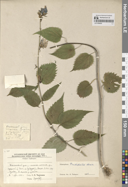
LE 01294243
Adenophora trachelioides auct. det. Fedorov, Andrey Aleksandrovich at 1956
Collectors: Czerepanov, Sergei Kirillovich Field collecting number: 255. Collection date: 08.08.1952. Administrative regions: RU - Primorskiy Kray - Khasanskiy Rayon. Expedition: Дальневосточная чайная экспедиция (1952 -1952)Groups of specimens: Образцы сектора Сибири и Дальнего Востока РоссииOriginal label text:Южное Приморье.
Coordinates (geographic position): 43° 20′ 44.58″ N, 131° 34′ 57.63″ EComment: Хасанский район, нижнее течение реки Грязной (бассейн реки Суйфуна), выше 3 км деревни Гусевки, в кустах у ручейка.
8.VIII.1952
С. К. Черепанов
Southern Primorye. Khasansky district, lower reaches of the Gryaznaya River (Suifun River basin), above 3 km of the village of Gusevka, in the bushes near a stream.
Record creation: 2024-08-10, Daria Yudova, PhotoScan D2.Citation: Specimen LE 01294243 // Virtual herbarium of Komarov Botanical Institute RAS — http://re.herbariumle.ru/012942438.08.1952
Coll. S.K. Cherepanov
LE 01294337
Adenophora liliifolia (L.) A. DC.
Field collecting number: 1873. Collection date: 13.08.1954. Administrative regions: KZ - Aqmola Oblysy. Groups of specimens: Образцы сектора Средней АзииOriginal label text:Акмолинская область, в 5 км к югу от города Сандыктау, речная терраса.
Coordinates (geographic position): 52° 34′ 6.9″ N, 68° 49′ 3.91″ EComment: № 1873
13.VIII.1954
Исаченко
Akmola region, 5 km south of the city of Sandyktau, river terrace.
№ 1873
13.08.1954
Coll. Isachenko
LE 01294242
Adenophora liliifolia (L.) A. DC.
Collectors: Reutt, A.T. Collection date: 07.08.1959. Administrative regions: RU - Magadanskaya Oblast'. Groups of specimens: Образцы сектора Сибири и Дальнего Востока РоссииOriginal label text:Район города Магадана, бухта Веселая, близ пирса. Крутой склон в распадок юго-восточной экспозиции. В ассоциации разнотравно-злаковый луг.
Coordinates (geographic position): 59° 29′ 57.82″ N, 150° 55′ 4.65″ EComment: 7.VIII.1959
А. Т. Реутт
Magadan area, Veselaya bay, near the pier. Steep slope into the ravine of south-eastern exposure.
Record creation: 2024-08-10, Daria Yudova, PhotoScan D2.Citation: Specimen LE 01294242 // Virtual herbarium of Komarov Botanical Institute RAS — http://re.herbariumle.ru/012942427.08.1959
Coll. A.T. Reutt
LE 01294336
Adenophora liliifolia (L.) A. DC. det. Grubov, Valery Ivanovich
Collectors: Grubov, Valery Ivanovich Field collecting number: 68. Collection date: 24.07.1957. Administrative regions: KZ - Qaraghandy Oblysy. Groups of specimens: Образцы сектора Средней АзииOriginal label text:Карагандинская область, горы Кент, осинник с ивняком по ручью, впадающему в Кызылкеныш, к СВ от верховья Жадыгера. Под пологом леса в сырой пойме.
Coordinates (geographic position): 49° 12′ 13.81″ N, 75° 57′ 9.23″ EComment: № 68
24.VII.1957
В. Грубов
Karaganda region, Kent mountains, aspen and willow forest along the stream flowing into Kyzylkenysh, to the NE of the upper reaches of Zhadyger. Under the forest canopy in a damp floodplain.
№ 68
24.07.1957
Coll. V. Grubov
LE 01294241
Adenophora pereskiifolia (Fisch. ex Roem. & Schult.) G. Don det. Fedorov, Andrey Aleksandrovich at 1956
Collection date: 29.08.1949. Administrative regions: RU - Sakhalinskaya Oblast'. Groups of specimens: Образцы сектора Сибири и Дальнего Востока РоссииOriginal label text:Остров Сахалин. Административный район Лесогорский. Побережье близ поселка Надеждино. Открытые, более-менее сухие участки близ дороги.
Coordinates (geographic position): 49° 16′ 36.08″ N, 142° 4′ 25.15″ EComment: 29.VIII.1949
Sakhalin Island. Lesogorsky administrative district. Coast near the village of Nadezhdino. Open, more or less dry areas near the road.
29.08.1949