View
Add
Copy
Edit
Delete
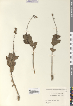
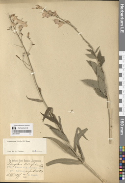
LE 01294230
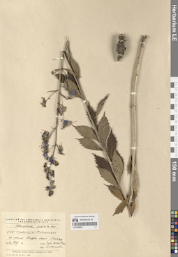
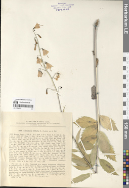
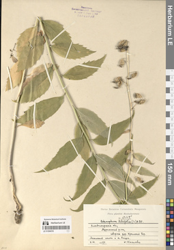
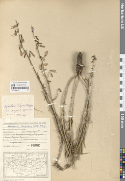
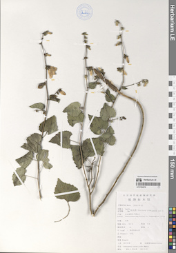
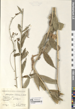
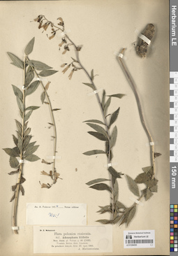
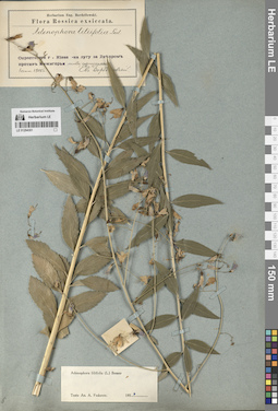
Adenophora triphylla (Thunb.) A. DC.
Collectors: S. Saito Field collecting number: 1030. Collection date: 28.08.1925. Administrative regions: JP - Japan. Groups of specimens: Образцы сектора Центральной и Восточной Азии; Соглашение Минобрнауки №075-15-2021-1056Original label text:Pref. Yamagata, mt. Chokai. Aug. 28, 1925 S. Saito
Coordinates (geographic position): 39° 6′ 3.62″ N, 140° 2′ 35.82″ ERecord creation: 2024-08-09, Daria Yudova, PhotoScan D2.Citation: Specimen LE 01294230 // Virtual herbarium of Komarov Botanical Institute RAS — http://re.herbariumle.ru/01294230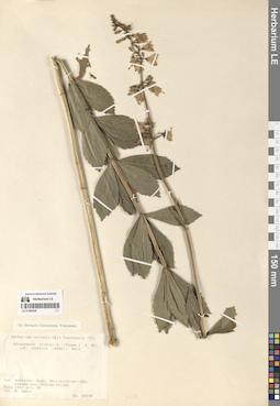
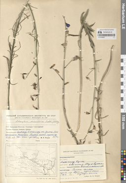
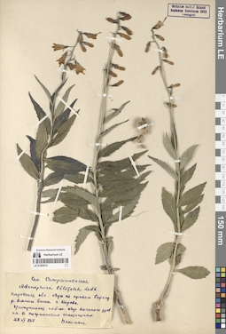
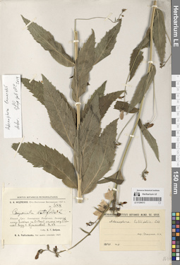
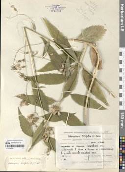
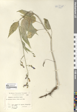
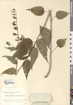
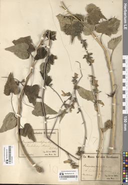
LE 01294229
Adenophora triphylla (Thunb.) A. DC.
Collectors: M. Amano Field collecting number: 00235. Collection date: 25.07.1986. Administrative regions: JP - Japan. Groups of specimens: Образцы сектора Центральной и Восточной Азии; Соглашение Минобрнауки №075-15-2021-1056Original label text:Hokkaido: Esan, Shirikishinai-cho, Kameda-gun, Oshima-shicho. 1986 July 25. M. Amano
Coordinates (geographic position): 41° 46′ 59.99″ N, 141° 4′ 59.99″ ERecord creation: 2024-08-09, Daria Yudova, PhotoScan D2.Citation: Specimen LE 01294229 // Virtual herbarium of Komarov Botanical Institute RAS — http://re.herbariumle.ru/01294229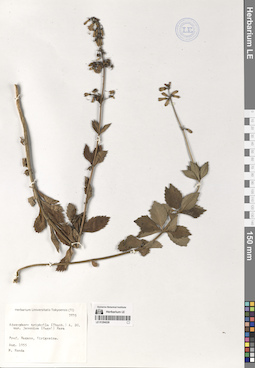
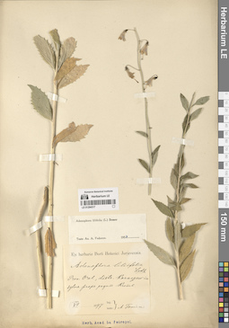
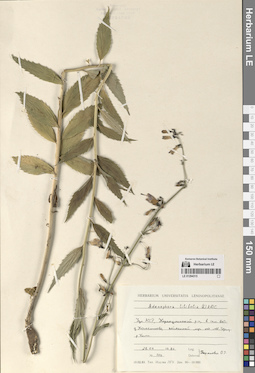
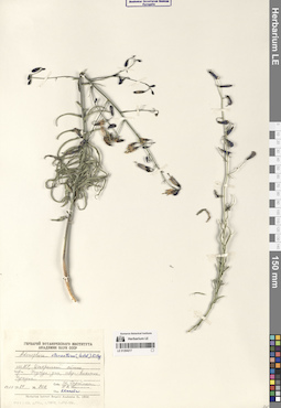
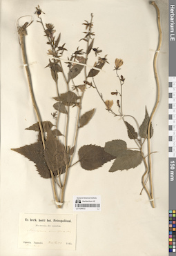
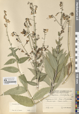
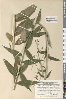
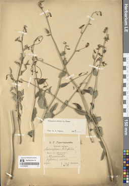
LE 01294228
Adenophora triphylla (Thunb.) A. DC.
Collectors: M. Honda Field collecting number: 7835. Collection date: 08.1955. Administrative regions: JP - Japan. Groups of specimens: Образцы сектора Центральной и Восточной Азии; Соглашение Минобрнауки №075-15-2021-1056Original label text:Pref. Nagano, Kirigamine. Aug. 1955. M. Honda
Coordinates (geographic position): 36° 6′ 0″ N, 138° 10′ 0.01″ ERecord creation: 2024-08-09, Daria Yudova, PhotoScan D2.Citation: Specimen LE 01294228 // Virtual herbarium of Komarov Botanical Institute RAS — http://re.herbariumle.ru/01294228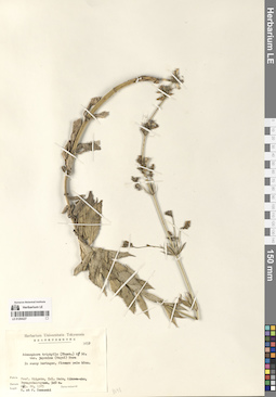
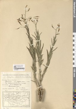
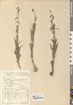
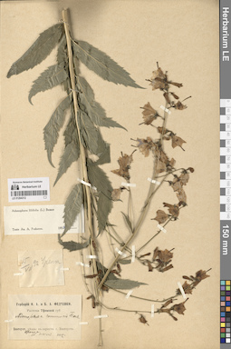
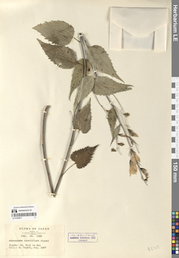
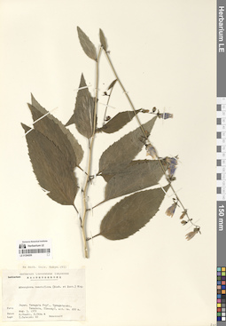
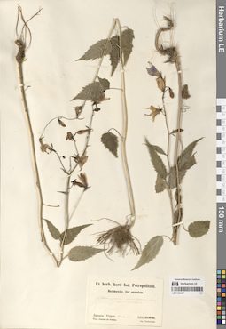
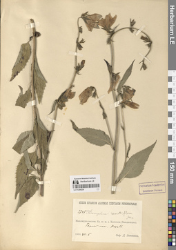
LE 01294227
Adenophora triphylla (Thunb.) A. DC.
Field collecting number: 5059. Collection date: 20.08.1985. Administrative regions: JP - Japan. Groups of specimens: Образцы сектора Центральной и Восточной Азии; Соглашение Минобрнауки №075-15-2021-1056Original label text:Pref. Niigata, isl. Sado, Aikawa-cho, Bunagadairayama, 940 m. Aug. 20, 1985. T. et F. Yamazaki.
Coordinates (geographic position): 38° 3′ 9.44″ N, 138° 15′ 12.54″ ERecord creation: 2024-08-09, Daria Yudova, PhotoScan D2.Citation: Specimen LE 01294227 // Virtual herbarium of Komarov Botanical Institute RAS — http://re.herbariumle.ru/01294227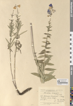
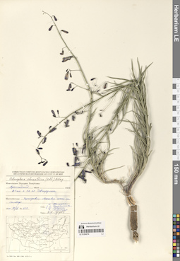
LE 01294226
Adenophora tricuspidata (Fisch. ex Roem. & Schult.) A. DC.
Collection date: 26.07.1957. Administrative regions: CN - China. Groups of specimens: Образцы сектора Центральной и Восточной Азии; Соглашение Минобрнауки №075-15-2021-1056Original label text:КНР, провинция Хэйлунцзян, с. Ляньфу. Высокая пойма Амура. 1957.26.VII. Сюй Тянь Фэнь.
Comment: People's Republic of China. Prov. Heilongjiang, the Langfu [?] village.High floodplain of the Amur River. 26.07.1957. Xu Tian Fa [?].
Record creation: 2024-08-09, Daria Yudova, PhotoScan D2.Citation: Specimen LE 01294226 // Virtual herbarium of Komarov Botanical Institute RAS — http://re.herbariumle.ru/01294226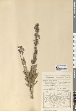
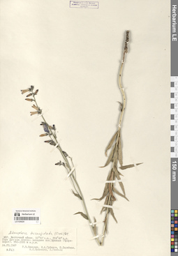
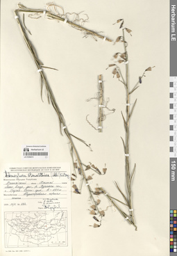
LE 01294225
Adenophora tricuspidata (Fisch. ex Roem. & Schult.) A. DC. det. Krestovskaya, Tatiana Valerievna at 2000
Collectors: Yunatov, Alexander Afanasievich Field collecting number: 16268. Collection date: 31.08.1949. Groups of specimens: Образцы сектора Центральной и Восточной Азии; Соглашение Минобрнауки №075-15-2021-1056Original label text:Монгольская Народная Республика.
Comment: Хэнтэйский аймак, сомон Цэнхэр-Мандал.
Перевал на водоразделе р.р. Цэнхэр-гол - Хэрулен.
Разнотравная горная степь.
1949.31.VIII.
№ 16268
Собр. А.А. Юнатов
Mongolian People's Republic.
Record creation: 2024-08-09, Daria Yudova, PhotoScan D2.Citation: Specimen LE 01294225 // Virtual herbarium of Komarov Botanical Institute RAS — http://re.herbariumle.ru/01294225Khentii Province, Tsenkhermandal district.
Pass on the watershed of the Tsenkher-gol and Kherlen rivers.
Mixed-grass mountain steppe.
31.08.1949
№ 16268
Leg. А.А. Yunatov
LE 01294224
Adenophora tricuspidata (Fisch. ex Roem. & Schult.) A. DC.
Collectors: Kamelin, Rudolph Vladimirovich; Gubanov, Ivan Alekseevich; Darijma, Sh.; Budantsev, Andrey Lvovich; Ganbold, E. Field collecting number: 2063. Collection date: 24.07.1987. Administrative regions: MN - Mongolia. Groups of specimens: Образцы сектора Центральной и Восточной Азии; Соглашение Минобрнауки №075-15-2021-1056Original label text:МНР. Восточный аймак. 50° 10' с.ш., 114° 45' в.д.
Coordinates (geographic position): 50° 10′ 0″ N, 114° 45′ 0″ EComment: Гора Хух-ула северо-западнее пос. Эранцав (Чулун-хорот). 950-1000 м н.у.м.
24.VII.1987
№ 2063
Р.В. Камелин, И.А. Губанов, Ш. Дариймаа, А.Л. Буданцев, Э. Ганболд.
Mongolian People's Republic. Eastern Province (moderm: Dornod province). 50°10' N, 114° 45' E.
Record creation: 2024-08-09, Daria Yudova, PhotoScan D2.Citation: Specimen LE 01294224 // Virtual herbarium of Komarov Botanical Institute RAS — http://re.herbariumle.ru/01294224Mount Khukh-ula northwest of the Ereentsav village (Chuluunkhoroot). 950-1000 m a.s.l.
24.VII.1987
№ 2063
R.V. Kamelin, I.A. Gubanov, Sh. Darijma, A.L. Budantsev, E. Ganbold.
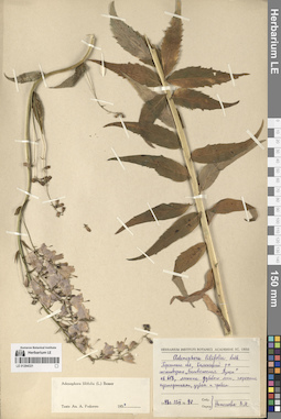
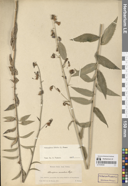
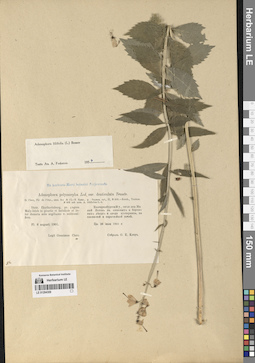
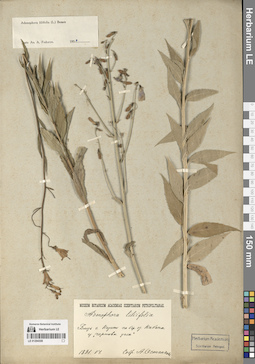
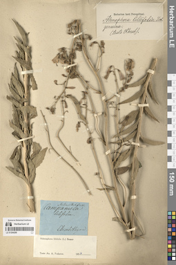
LE 01294321
Adenophora liliifolia (L.) A. DC. det. Fedorov, Andrey Aleksandrovich at 1954
Collectors: Nikolaeva V.M. Field collecting number: 40. Collection date: 22.07.1948. Administrative regions: BY - Belarus. Groups of specimens: Образцы сектора Восточной ЕвропыOriginal label text:Брестская обл., Каменецкий р-н, госзаповедник "Беловежская пуща", кв. 618, лесосека дубового леса, поросшая кустарниками, дубом и грабом.
Coordinates (geographic position): 52° 34′ 13.09″ N, 23° 48′ 10.91″ EComment: 1948 г. 22.VII.
№ 40.
Собр. Николаева В.М.
Brest region, Kamyanyets District, Belavezhskaya Pushcha National Park, oak forest.
Record creation: 2024-08-10, Daria Yudova, PhotoScan D2.Citation: Specimen LE 01294321 // Virtual herbarium of Komarov Botanical Institute RAS — http://re.herbariumle.ru/0129432122.07.1948
№ 40.
V. M. Nikolaeva
LE 01294223
Adenophora sublata Kom. det. Lipatova, V. V.
Collection date: 26.07.1957. Administrative regions: CN - China. Groups of specimens: Образцы сектора Центральной и Восточной Азии; Соглашение Минобрнауки №075-15-2021-1056Original label text:КНР. Провинция Хэйлунцзян. На пойме Амура близ с. Ляньфу.
Comment: 1957.26.VII
Собр. Сюй Тянь Фэнь.
People's Republic of China. Prov. Heilongjiang. On the floodplain of the Amur River near the Langfu [?] village.
Record creation: 2024-08-09, Daria Yudova, PhotoScan D2.Citation: Specimen LE 01294223 // Virtual herbarium of Komarov Botanical Institute RAS — http://re.herbariumle.ru/0129422326.07.1957
Leg. Xu Tian Fa [?]
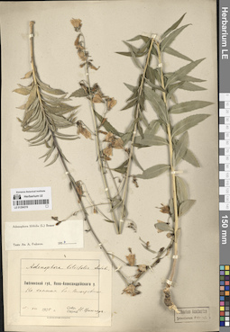
LE 01294320
Adenophora liliifolia (L.) A. DC. det. Fedorov, Andrey Aleksandrovich at 1954
Collectors: Downar, N. Collection date: 1862. Administrative regions: BY - Mogilyov Oblast. Groups of specimens: Образцы сектора Восточной ЕвропыOriginal label text:Prov. Mohilew, praesertim circa urbem Mohilew ad Borysthenem.
Coordinates (geographic position): 53° 53′ 54.23″ N, 30° 23′ 6.24″ EComment: Conf. Bull. soc. de Moscou, 1862
N. Downar
Belarus, Mogilev region, near Mogilev on the Dnieper river.
Record creation: 2024-08-10, Daria Yudova, PhotoScan D2.Citation: Specimen LE 01294320 // Virtual herbarium of Komarov Botanical Institute RAS — http://re.herbariumle.ru/01294320Conf. Bull. soc. de Moscou, 1862
N. Downar
LE 01294319
Adenophora liliifolia (L.) A. DC. det. Fedorov, Andrey Aleksandrovich at 1954
Collectors: Zinger, Nikolai Wasiljevicz (Zinger, Nikola Vasiljevič) Collection date: 15.07.1905. Administrative regions: PL - Poland. Groups of specimens: Образцы сектора Восточной ЕвропыOriginal label text:Люблинской губ., Ново-Александрийского у.
Coordinates (geographic position): 51° 25′ 43.38″ N, 21° 57′ 44.51″ EComment: На холмах бл. с. Влостовице.
15.VII.1905
Н. Цингер
Lublin province, Novo-Alexandriisk district.
Record creation: 2024-08-10, Daria Yudova, PhotoScan D2.Citation: Specimen LE 01294319 // Virtual herbarium of Komarov Botanical Institute RAS — http://re.herbariumle.ru/01294319On the hills near the Włostowice village.
15.07.1905
N. Zinger
Modern: Poland, Lublin Voivodeship, Włostowice, a district of the town of Puławy.
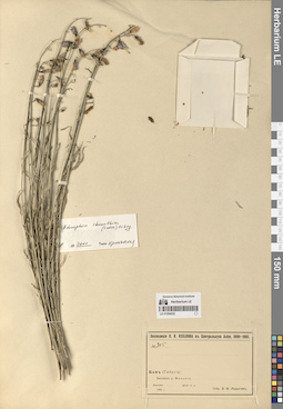
LE 01294222
Adenophora stenanthina (Ledeb.) Kitag. det. Krestovskaya, Tatiana Valerievna at 2000
Collectors: V.O. Ladygin Field collecting number: 305. Collection date: 1900. Administrative regions: CN - China. Expedition: Экспедиция П.К. Козлова в Центральную Азию (1899)Groups of specimens: Образцы сектора Центральной и Восточной Азии; Соглашение Минобрнауки №075-15-2021-1056Original label text:№ 305
Comment: Кам (Тибет)
Бассейн р. Меконга.
1900 г.
Собр. В.О. Ладыгин
№ 305
Record creation: 2024-08-09, Daria Yudova, PhotoScan D2.Citation: Specimen LE 01294222 // Virtual herbarium of Komarov Botanical Institute RAS — http://re.herbariumle.ru/01294222Kham (Tibet)
The Mekong river basin.
1900
Coll. V.O. Ladygin
LE 01294318
Adenophora liliifolia (L.) A. DC. det. Tikhomirov, Vadim Nikolaevich
Collectors: Tikhomirov, Vadim Nikolaevich; Alexeev, Evgenii Borisovich; Vinogradova, Vera Mikhailovna; Oktjabreva Natalya Borisovna Collection date: 18.07.1973. Administrative regions: RU - Ryazanskaya Oblast'. Groups of specimens: Образцы сектора Восточной ЕвропыOriginal label text:Рязанская обл., Спасский р-н, между кордонами "Тышлово" и "Липовая гора" на левом берегу р. Пры, в дубраве по берегу оз. Лопата.
Собр. В. Тихомиров, Е. Алексеев, В. Виноградова и Н. Октябрева, опр. В. Тихомиров. - Prov. Rjasan, distr. Spassk, reservatum naturae Okense, inter praed. "Tyschlovo" et "Lipovaja gora", ad ripam sinistram fl. Pra, in querceto ad ripam lac. Lopata. Leg. V. Tichomirov, E. Alexeev, V. Vinogradova et N. Octjabreva, det. V. Tichomirov.
1973 VII 18.
Modern: Russia, Ryazan region, Spassky district, on the left shore of the Pra river, oak forest on the Lopata lake.
18.07.1973
Leg. V. Tikhomirov, E. Alexeev, V. Vinogradova and N. Octjabreva
LE 01294221
Adenophora stenanthina (Ledeb.) Kitag.
Collectors: M.P. Petrov Collection date: 12.08.1958. Administrative regions: CN - China. Groups of specimens: Образцы сектора Центральной и Восточной Азии; Соглашение Минобрнауки №075-15-2021-1056Original label text:КНР. Провинция Ганьсу.
Comment: Ланьчжоу, в 25 км к югу от Кулона. Восточная оконечность Наньшань. Пологие склоны низких гор. Горная степь с кустарником. 2450 м.
12.VIII.1958
М.П. Петров
China. Gansu Province. Lanzhou, 25 km south of Kulon. Eastern end of Nanshan. Gentle slopes of low mountains. Mountain steppe with shrubs. 2450 m.
Record creation: 2024-08-09, Daria Yudova, PhotoScan D2.Citation: Specimen LE 01294221 // Virtual herbarium of Komarov Botanical Institute RAS — http://re.herbariumle.ru/0129422112.08.1958
Coll. M.P. Petrov
LE 01294317
Adenophora liliifolia (L.) A. DC. det. Fedorov, Andrey Aleksandrovich at 1954
Collectors: Fomin, Alexander Vasilyevich Collection date: 07.1897. Administrative regions: RU - Orlovskaya Oblast'. Groups of specimens: Образцы сектора Восточной ЕвропыOriginal label text:Prov. Orel, distr. Karaczew in sylva prope pagum Kreml.
Coordinates (geographic position): 52° 55′ 46.7″ N, 35° 18′ 53.54″ ERecord creation: 2024-08-10, Daria Yudova, PhotoScan D2.Citation: Specimen LE 01294317 // Virtual herbarium of Komarov Botanical Institute RAS — http://re.herbariumle.ru/01294317VII.1897
A. Fomin
LE 01294220
Adenophora stenanthina (Ledeb.) Kitag. det. Krestovskaya, Tatiana Valerievna at 2000
Collectors: Yunatov, Alexander Afanasievich Field collecting number: 16079. Collection date: 19.08.1949. Administrative regions: MN - Mongolia. Groups of specimens: Образцы сектора Центральной и Восточной Азии; Соглашение Минобрнауки №075-15-2021-1056Original label text:Монгольская Народная Республика. Восточный аймак, Гурбан-загал сомон. Урочище Шавортэ-обо в 13-15 км к западу от озера Шавортэ-нур. Каменистая степь.
Coordinates (geographic position): 49° 51′ 28.94″ N, 116° 25′ 43.46″ EComment: № 16079
19.VIII.1949
А. А. Юнатов
Mongolia. Eastern aimag, Gurban-zagal somon. The Shavorte-obo tract is 13-15 km west of Lake Shavorte-nur. Rocky steppe.
№ 1607919.08.1949
Coll. A. A. Yunatov
LE 01294316
Adenophora liliifolia (L.) A. DC.
Collectors: Kiseleva, Clara Vladimirovna Field collecting number: 12117. Collection date: 03.09.1977. Administrative regions: RU - Vladimirskaya Oblast'. Groups of specimens: Образцы сектора Восточной ЕвропыOriginal label text:Владимирская область, Муромский район, севернее деревни Красный Бор. Лесистый склон к озеру Виша.
Coordinates (geographic position): 55° 49′ 38.38″ N, 42° 18′ 17.29″ EComment: 3.IX.1977
К. Киселева
Vladimir region, Murom district, north of the village of Krasny Bor. Wooded slope to Lake Visha.
03.09.1977
Coll. K. Kiseleva
LE 01294219
Adenophora stenanthina (Ledeb.) Kitag. det. Krestovskaya, Tatiana Valerievna at 2000
Collectors: Yunatov, Alexander Afanasievich Field collecting number: 16267. Collection date: 31.08.1949. Administrative regions: MN - Mongolia. Groups of specimens: Образцы сектора Центральной и Восточной Азии; Соглашение Минобрнауки №075-15-2021-1056Original label text:Монгольская Народная Республика. Хэнтэйский аймак, Цэнхэр-Мандал сомон. Перевал на водоразделе рек Цэнхэр-гол - Хэрулен. Разнотравная горная степь.
Coordinates (geographic position): 47° 20′ 36.35″ N, 109° 0′ 59.98″ EComment: № 16267
31.VIII.1949
А. А. Юнатов
Mongolia. Khentii aimag, Tsenkher-Mandal sum. Pass on the watershed of the Tsenkher-gol and Herlen rivers. Mountain steppe with mixed grasses.
Record creation: 2024-08-09, Daria Yudova, PhotoScan D2.Citation: Specimen LE 01294219 // Virtual herbarium of Komarov Botanical Institute RAS — http://re.herbariumle.ru/01294219№ 16267
31.08.1949
Coll. A. A. Yunatov
LE 01294315
Adenophora liliifolia (L.) A. DC. det. Baranova, Olga Germanovna
Collectors: Baranova, Olga Germanovna Field collecting number: 779. Collection date: 28.07.1986. Administrative regions: RU - Udmurtskaya Respublika - Karakulinskiy Rayon. Groups of specimens: Образцы сектора Восточной ЕвропыOriginal label text:Удмуртская АССР, Каракулинский район, в 1 км восточнее деревни Колесниково, пойменный луг по левому берегу реки Ками.
Coordinates (geographic position): 55° 58′ 19.61″ N, 53° 32′ 6.32″ EComment: № 779
28.07.1986
Баранова О. Г.
Udmurtia, Karakulinsky district, 1 km east of the village of Kolesnikovo, floodplain meadow along the left bank of the Kamа River.
Record creation: 2024-08-10, Daria Yudova, PhotoScan D2.Citation: Specimen LE 01294315 // Virtual herbarium of Komarov Botanical Institute RAS — http://re.herbariumle.ru/01294315№ 779
28.07.1986
Coll. O. G. Baranova
LE 01294314
Adenophora liliifolia (L.) A. DC.
Collectors: Vasilevich, Vladislav Ivanovich Collection date: 22.06.1951. Administrative regions: RU - Kirovskaya Oblast'. Groups of specimens: Образцы сектора Восточной ЕвропыOriginal label text:Кировская область. Луга на правом берегу реки Вятки выше города Кирова. Центральная пойма. Луг высокого уровня. В погремковых ассоциациях.
Coordinates (geographic position): 58° 43′ 45.86″ N, 49° 30′ 38.39″ EComment: 22.VI.1951
Василевич
Kirov Region. Meadows on the right bank of the Vyatka River above the city of Kirov. Central floodplain. High-level meadow.
Record creation: 2024-08-10, Daria Yudova, PhotoScan D2.Citation: Specimen LE 01294314 // Virtual herbarium of Komarov Botanical Institute RAS — http://re.herbariumle.ru/0129431422.06.1951
Vasilevich
LE 01294218
Adenophora stenanthina (Ledeb.) Kitag.
Collectors: Kalinina, A.V. Collection date: 02.08.1949. Administrative regions: MN - Mongolia. Groups of specimens: Образцы сектора Центральной и Восточной Азии; Соглашение Минобрнауки №075-15-2021-1056Original label text:Монгольская Народная Республика.
Coordinates (geographic position): 49° 6′ 57.12″ N, 104° 27′ 56.8″ EComment: Селенгинский аймак, Барун-Бурин сомон. Северный склон водораздела между реками Бургултай и Хангал. Урочище Уртым ам. Полянки в лиственничном лесу и опушки леса.
2.VIII.1949
А. В. Калинина
Mongolia. Selenginsky province, Barun-Burin sum. Northern slope of the watershed between the Burgultai and Khangal rivers. Urtym am. Glades in the larch forest and forest edges.
Record creation: 2024-08-09, Daria Yudova, PhotoScan D2.Citation: Specimen LE 01294218 // Virtual herbarium of Komarov Botanical Institute RAS — http://re.herbariumle.ru/012942182.08.1949
Coll. A.V. Kalinina
LE 01294313
Adenophora liliifolia (L.) A. DC. det. Igoschina, Kapitolina Nikolaevna at 1940
Collectors: Bobrov, Evgeniy Grigorievich Field collecting number: 588. Collection date: 03.07.1927. Administrative regions: RU - Bashkortostan - Burzyanskiy Rayon. Groups of specimens: Образцы сектора Восточной ЕвропыOriginal label text:Южный Урал. Башкирская республика, Зилаирский кантон. Ельник на СВ склоне по реке Белой близ деревни Кутановой.
Coordinates (geographic position): 52° 58′ 50.58″ N, 57° 2′ 47.49″ EComment: 3.VII.1927
Е. Г. Бобров
Southern Urals. Bashkir Republic, Zilairsky canton. Spruce forest on the NE slope along the Belaya River near the village of Kutanovo.
Record creation: 2024-08-10, Daria Yudova, PhotoScan D2.Citation: Specimen LE 01294313 // Virtual herbarium of Komarov Botanical Institute RAS — http://re.herbariumle.ru/01294313№ 588
3.07.1927
Coll. E. G. Bobrov
LE 01294217
Adenophora stenanthina (Ledeb.) Kitag. det. Kamelin, Rudolph Vladimirovich
Collectors: Darijma, Sh.; Kamelin, Rudolph Vladimirovich Field collecting number: 902. Collection date: 13.08.1984. Administrative regions: MN - Mongolia. Groups of specimens: Образцы сектора Центральной и Восточной Азии; Соглашение Минобрнауки №075-15-2021-1056Original label text:МНР, Центральный аймак, горы Унджул-ула, северо-восточнее Унджула.
Coordinates (geographic position): 46° 53′ 13.49″ N, 105° 48′ 20.88″ EComment: № 902
13.08.1984
Ш. Дариймаа, Р. В. Камелин
Mongolia. Central province, Unjul-ula mountains, northeast of Unjul.
Record creation: 2024-08-09, Daria Yudova, PhotoScan D2.Citation: Specimen LE 01294217 // Virtual herbarium of Komarov Botanical Institute RAS — http://re.herbariumle.ru/01294217№ 902
13.08.1984
Coll. Sh. Darijma, R. V. Kamelin
LE 01294312
Adenophora liliifolia (L.) A. DC. det. Fedorov, Andrey Aleksandrovich at 1954
Collectors: Fedtschenko, Olga Alexandrowna; Fedtschenko, Boris Alexeevich Collection date: 15.07.1892. Administrative regions: RU - Chelyabinskaya Oblast'. Groups of specimens: Образцы сектора Восточной ЕвропыOriginal label text:Златоустовский уезд: в окрестностях города Златоуста. Уренга.
Coordinates (geographic position): 55° 3′ 31.35″ N, 59° 32′ 3.91″ EComment: 15 июля 1892 г.
О. А. и Б. А. Федченко
Zlatoust district: in the vicinity of the city of Zlatoust. Urenga.
Record creation: 2024-08-10, Daria Yudova, PhotoScan D2.Citation: Specimen LE 01294312 // Virtual herbarium of Komarov Botanical Institute RAS — http://re.herbariumle.ru/0129431215.07.1892
Coll. O. A. and B. A. Fedtschenko
LE 01294216
Adenophora trachelioides auct.
Administrative regions: CN - China. Groups of specimens: Образцы сектора Центральной и Восточной Азии; Соглашение Минобрнауки №075-15-2021-1056Record creation: 2024-08-09, Daria Yudova, PhotoScan D2.Citation: Specimen LE 01294216 // Virtual herbarium of Komarov Botanical Institute RAS — http://re.herbariumle.ru/01294216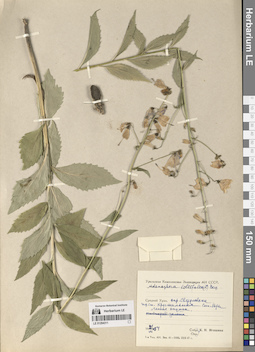
LE 01294311
Adenophora liliifolia (L.) A. DC.
Collectors: Igoschina, Kapitolina Nikolaevna Collection date: 21.07.1954. Administrative regions: RU - Sverdlovskaya Oblast'. Groups of specimens: Образцы сектора Восточной ЕвропыOriginal label text:Средний Урал. Окрестности Свердловска. Жд станция Хрустальная. Сосновые боры. Лесная опушка.
Coordinates (geographic position): 56° 51′ 32.24″ N, 60° 11′ 5.68″ EComment: 21.VII.1954
К. Н. Игошина
Middle Urals. Sverdlovsk environs. Khrustalnaya railway station. Pine forests. Forest edge.
Record creation: 2024-08-10, Daria Yudova, PhotoScan D2.Citation: Specimen LE 01294311 // Virtual herbarium of Komarov Botanical Institute RAS — http://re.herbariumle.ru/0129431121.07.1954
Coll. K. N. Igoschina
LE 01294215
Adenophora trachelioides auct.
Collectors: Basilewsky, Stepan Ivanovich Field collecting number: 233. Groups of specimens: Образцы сектора Центральной и Восточной Азии; Соглашение Минобрнауки №075-15-2021-1056Original label text:№ 233
Comment: Лин-дян-хун
Китай: провинция Чжили, окрестности Пекина, горы Похуашань.
1850-1858.
Собрал С. И. Базилевский
№ 233 Lin-dian-hong
Record creation: 2024-08-09, Daria Yudova, PhotoScan D2.Citation: Specimen LE 01294215 // Virtual herbarium of Komarov Botanical Institute RAS — http://re.herbariumle.ru/01294215China: Zhili province, environs of Beijing, Pohuashan mountains.
1850-1858.
Collected by S. I. Bazilevsky
LE 01294310
Adenophora liliifolia (L.) A. DC. det. Fedorov, Andrey Aleksandrovich at 1954
Collectors: Panfiljev G. Collection date: 27.07.1898. Administrative regions: RU - Chelyabinskaya Oblast' - Gorod Chelyabinsk. Groups of specimens: Образцы сектора Восточной ЕвропыOriginal label text:Березняк у Челябинска.
Coordinates (geographic position): 55° 8′ 23.54″ N, 61° 20′ 52.55″ EComment: 27.VII.1898
Г. Панфильев
Bereznyak near Chelyabinsk.
Record creation: 2024-08-10, Daria Yudova, PhotoScan D2.Citation: Specimen LE 01294310 // Virtual herbarium of Komarov Botanical Institute RAS — http://re.herbariumle.ru/0129431027.07.1898
Coll. G. Panfiljev
LE 01294214
Adenophora stenanthina (Ledeb.) Kitag. det. Grubov, Valery Ivanovich
Field collecting number: 358. Collection date: 18.07.1970. Administrative regions: MN - Mongolia. Groups of specimens: Образцы сектора Центральной и Восточной Азии; Соглашение Минобрнауки №075-15-2021-1056Original label text:Архангайский аймак. В 4 км к СВ от Тэвшрулэха. Разнотравно-овсецовая степь на шлейфе.
Coordinates (geographic position): 47° 24′ 52.91″ N, 101° 59′ 23.33″ EComment: № 358
18.VII.1970
Д. Банзрагч, З. В. Карамышева, Е. М. Лавренко, Н. Манибазар
Arkhangai aimak. 4 km NE from Tuvshrulekh. Forb-oat steppe.
Record creation: 2024-08-09, Daria Yudova, PhotoScan D2.Citation: Specimen LE 01294214 // Virtual herbarium of Komarov Botanical Institute RAS — http://re.herbariumle.ru/01294214№ 358
18.07.1970
Coll. D. Banzragch, Z. V. Karamysheva, E. M. Lavrenko, N. Manibazar
LE 01294309
Adenophora liliifolia (L.) A. DC. det. Fedorov, Andrey Aleksandrovich at 1954
Collectors: Kler, Onisim Egorovich Collection date: 08.08.1901. Administrative regions: RU - Sverdlovskaya Oblast' - Municipalnoe obrazovanie «gorod Ekaterinburg». Groups of specimens: Образцы сектора Восточной ЕвропыOriginal label text:Distr. Ekatherinburg, pr. pagum Maly-Istok in pinetis et betulinis et inter dumeta solo argillaceo v. subhumifero.
Coordinates (geographic position): 56° 46′ 30.8″ N, 60° 49′ 38.5″ ERecord creation: 2024-08-10, Daria Yudova, PhotoScan D2.Citation: Specimen LE 01294309 // Virtual herbarium of Komarov Botanical Institute RAS — http://re.herbariumle.ru/01294309Fl. 8 augusti 1901
Onesimus Clerc.
Екатеринбургский уезд, около деревни Малый Исток в сосновых и березовых лесах и среди кустарника, на глинистой и перегнойной почве.
Цв. 26 июля 1901 г.
О. Е. Клер
LE 01294213
Adenophora stenanthina (Ledeb.) Kitag. det. Grubov, Valery Ivanovich
Collectors: Golubkova, Nina Siergeovna; Tsetsegma, D.; U. Tsogt Field collecting number: 292. Collection date: 14.07.1974. Administrative regions: MN - Mongolia. Groups of specimens: Образцы сектора Центральной и Восточной Азии; Соглашение Минобрнауки №075-15-2021-1056Original label text:Монгольская Народная Республика.
Comment: Хэнтэйский аймак, сомон Хэнтэй.
Монг.-Даур., долина реки Хурахот-гол, г. Эрдэне-Цогт-ула, H = 1500 м. Разнотравная горная степь.
№ 292.
14.VII.1974
Н. С. Голубкова, У. Цогт, Д. Цэцэгмаа
Mongolia. Khentei aimak, Khentei somon. Khurahot-gol river valley, Erdene-Tsogt-ula mountain, H = 1500 m. Mountain steppe with mixed grasses.
Record creation: 2024-08-09, Daria Yudova, PhotoScan D2.Citation: Specimen LE 01294213 // Virtual herbarium of Komarov Botanical Institute RAS — http://re.herbariumle.ru/01294213№ 292.
14.07.1974
Coll. N. S. Golubkova, U. Tsogt, D. Tsetsegma,
LE 01294308
Adenophora liliifolia (L.) A. DC. det. Fedorov, Andrey Aleksandrovich at 1954
Collectors: Ostankow, A. Collection date: 06.1891. Administrative regions: RU - Tatarstan - Gorod Kazan'. Groups of specimens: Образцы сектора Восточной ЕвропыOriginal label text:Близ города Казани по берегу озера Кабан у "Чортовы углы".
Coordinates (geographic position): 55° 44′ 23.33″ N, 49° 9′ 4.65″ EComment: VI.1891
А. Останков
Near the city of Kazan, on the shore of Lake Kaban, at the "Devil's Corners".
Record creation: 2024-08-10, Daria Yudova, PhotoScan D2.Citation: Specimen LE 01294308 // Virtual herbarium of Komarov Botanical Institute RAS — http://re.herbariumle.ru/0129430806.1891
Coll. A. Ostankow
LE 01294307
Adenophora liliifolia (L.) A. DC. det. Fedorov, Andrey Aleksandrovich at 1954
Collection date: 16.07.1897. Administrative regions: RU - Respublika Mariy-El. Groups of specimens: Образцы сектора Восточной ЕвропыOriginal label text:Prov. Kasan d. Kosmodemjansk. Pr. Korotni, in fruticetis.
Coordinates (geographic position): 56° 21′ 39.99″ N, 46° 32′ 34.84″ ERecord creation: 2024-08-10, Daria Yudova, PhotoScan D2.Citation: Specimen LE 01294307 // Virtual herbarium of Komarov Botanical Institute RAS — http://re.herbariumle.ru/0129430716.VII.1897
A. Busch
LE 01294212
Adenophora remotiflora (Siebold & Zucc.) Miq.
Collectors: Maximowicz, Carl Johann Collection date: 09.09.1863. Administrative regions: JP - Japan. Groups of specimens: Образцы сектора Центральной и Восточной Азии; Соглашение Минобрнауки №075-15-2021-1056Original label text:Japonia. Nagasaki. Simabara.
Record creation: 2024-08-09, Daria Yudova, PhotoScan D2.Citation: Specimen LE 01294212 // Virtual herbarium of Komarov Botanical Institute RAS — http://re.herbariumle.ru/012942129/21 Sept. 1863
Maximowicz
LE 01294306
Adenophora liliifolia (L.) A. DC. det. Fedorov, Andrey Aleksandrovich at 1976
Collectors: Gladkova, Valentina Nikolaevna; Leonova, Tamara Geogrievna Field collecting number: 169. Collection date: 13.08.1970. Administrative regions: RU - Voronezhskaya Oblast' - Borisoglebsky Urban Okrug. Groups of specimens: Образцы сектора Восточной ЕвропыOriginal label text:Воронежская область. Берег реки Хопер недалеко от границы Саратовской области, село Третьяково [= Третьяки] в 35 км к востоку от города Борисоглебска, в дубово-тополево-кленовом лесу.
Coordinates (geographic position): 51° 23′ 20.53″ N, 42° 28′ 59.16″ EComment: № 169
13.VIII.1970
В. Н. Гладкова, Т. Г. Леонова
Voronezh Region. Bank of the Khoper River near the border of Saratov Region, village of Tretyakovo [= Tretyaki] 35 km east of the city of Borisoglebsk, in an oak-poplar-maple forest.
Record creation: 2024-08-10, Daria Yudova, PhotoScan D2.Citation: Specimen LE 01294306 // Virtual herbarium of Komarov Botanical Institute RAS — http://re.herbariumle.ru/01294306№ 169
13.08.1970
Coll. V. N. Gladkova, T. G. Leonova
LE 01294211
Adenophora remotiflora (Siebold & Zucc.) Miq.
Field collecting number: 1552. Collection date: 08.1957. Administrative regions: JP - Japan. Groups of specimens: Образцы сектора Центральной и Восточной Азии; Соглашение Минобрнауки №075-15-2021-1056Original label text:Honsu: Mt. Fudji in Kai
Record creation: 2024-08-09, Daria Yudova, PhotoScan D2.Citation: Specimen LE 01294211 // Virtual herbarium of Komarov Botanical Institute RAS — http://re.herbariumle.ru/01294211Aug. 1957
M. Togasi
LE 01294305
Adenophora liliifolia (L.) A. DC.
Collectors: Lavrenko, Eugeny Mikhailovic Collection date: 08.08.1935. Administrative regions: RU - Penzenskaya Oblast'. Groups of specimens: Образцы сектора Восточной ЕвропыOriginal label text:Пензенская область. Лесостепной заповедник "Арбеково".
Coordinates (geographic position): 53° 19′ 15.96″ N, 46° 47′ 45.06″ EComment: 8.VIII.1935
Е. М. Лавренко
Penza region. Forest-steppe reserve "Arbekovo".
8.08.1935
Coll. E. M. Lavrenko
LE 01294210
Adenophora remotiflora (Siebold & Zucc.) Miq.
Collection date: 05.08.1963. Administrative regions: JP - Japan. Groups of specimens: Образцы сектора Центральной и Восточной Азии; Соглашение Минобрнауки №075-15-2021-1056Original label text:in deciduous forest, flower pale blue.
Record creation: 2024-08-09, Daria Yudova, PhotoScan D2.Citation: Specimen LE 01294210 // Virtual herbarium of Komarov Botanical Institute RAS — http://re.herbariumle.ru/01294210Prov. Sagami, Mt. Tanzawa, Hirugatake, alt. 1200 m.
Aug. 5, 1963
T. Toshuka
LE 01294304
Adenophora liliifolia (L.) A. DC. det. Fedorov, Andrey Aleksandrovich at 1954
Collectors: Igoschina, Kapitolina Nikolaevna Collection date: 31.07.1950. Administrative regions: UA - Zakarpattia Oblast - Mukachevo Raion. Groups of specimens: Образцы сектора Восточной ЕвропыOriginal label text:Закарпатская область УССР. Близ города Мукачево. Велика гора. Склон с дубом.
Coordinates (geographic position): 48° 25′ 15.66″ N, 22° 45′ 0.56″ EComment: 31.VII.1950
К. Н. Игошина
Ukraine. Zakarpattia region. Near the city of Mukachevo. Velika Gora. Slope with oak.
Record creation: 2024-08-10, Daria Yudova, PhotoScan D2.Citation: Specimen LE 01294304 // Virtual herbarium of Komarov Botanical Institute RAS — http://re.herbariumle.ru/0129430431.07.1950
Coll. K. N. Igoschina
LE 01294209
Adenophora remotiflora (Siebold & Zucc.) Miq.
Collection date: 03.08.1970. Administrative regions: JP - Japan. Groups of specimens: Образцы сектора Центральной и Восточной Азии; Соглашение Минобрнауки №075-15-2021-1056Original label text:Japan. Yamagata pref., Yamagata-shi, Yamadera, Yusenkyo, alt. ca. 400 m.
Record creation: 2024-08-09, Daria Yudova, PhotoScan D2.Citation: Specimen LE 01294209 // Virtual herbarium of Komarov Botanical Institute RAS — http://re.herbariumle.ru/01294209Aug. 3, 1970
H. Ohashi, H. Ohba, Y. Tateishi
LE 01294303
Adenophora liliifolia (L.) A. DC.
Groups of specimens: Образцы сектора Восточной ЕвропыOriginal label text:Ucrainia. Rozyn, distr. Lipowiec.
Record creation: 2024-08-10, Daria Yudova, PhotoScan D2.Citation: Specimen LE 01294303 // Virtual herbarium of Komarov Botanical Institute RAS — http://re.herbariumle.ru/01294303Na polankach lesnych [= In forest clearings.]. Zebr. 22. lipca 1900 [= 22.07.1900]
A. Markiewiczowna
LE 01294208
Adenophora remotiflora (Siebold & Zucc.) Miq.
Collection date: 02.09.1975. Administrative regions: JP - Japan. Groups of specimens: Образцы сектора Центральной и Восточной Азии; Соглашение Минобрнауки №075-15-2021-1056Original label text:Gunma pref., Tano-gun, Manba-machi, alt. 900 m.
Record creation: 2024-08-09, Daria Yudova, PhotoScan D2.Citation: Specimen LE 01294208 // Virtual herbarium of Komarov Botanical Institute RAS — http://re.herbariumle.ru/01294208Sept. 2, 3 1975
J. Murata, Y. Tateishi, Y. Kadota
LE 01294302
Adenophora liliifolia (L.) A. DC.
Collectors: Tzvelev, Nikolai Nikolaievich Field collecting number: 132. Collection date: 26.07.1976. Administrative regions: UA - Kharkivs'ka Oblast'. Groups of specimens: Образцы сектора Восточной ЕвропыOriginal label text:Харьковская область, окрестности города Чугуев, дубово-вязовый лес в пойме Северского Донца (правый берег) немного выше места впадения в него реки Уды.
Coordinates (geographic position): 49° 46′ 48.45″ N, 36° 33′ 53.7″ EComment: № 132
26.VII.1976
Н. Цвелев
Kharkiv region, the outskirts of the city of Chuguev, oak-elm forest in the floodplain of the Seversky Donets (right bank) slightly above the confluence of the Uda River.
Record creation: 2024-08-10, Daria Yudova, PhotoScan D2.Citation: Specimen LE 01294302 // Virtual herbarium of Komarov Botanical Institute RAS — http://re.herbariumle.ru/01294302№ 132
26.07.1976
Coll. N. Tzvelev
LE 01294207
Adenophora remotiflora (Siebold & Zucc.) Miq.
Collectors: Tschonoski, S. Collection date: 1864. Administrative regions: JP - Japan. Groups of specimens: Образцы сектора Центральной и Восточной Азии; Соглашение Минобрнауки №075-15-2021-1056Original label text:Japonia. Nippon. Hakone
Coordinates (geographic position): 35° 13′ 55.26″ N, 139° 1′ 27.6″ ERecord creation: 2024-08-09, Daria Yudova, PhotoScan D2.Citation: Specimen LE 01294207 // Virtual herbarium of Komarov Botanical Institute RAS — http://re.herbariumle.ru/012942071864
leg. Tschonoski
LE 01294301
Adenophora liliifolia (L.) A. DC. det. Fedorov, Andrey Aleksandrovich at 1954
Collectors: Bordzilowski, Eugen Iwanowitsch Collection date: 01.09.1905. Administrative regions: UA - Kyiv Oblast. Groups of specimens: Образцы сектора Сибири и Дальнего Востока РоссииOriginal label text:Окрестности города Киева - на лугу за Днепром против Межигорья. Между кустарниками.
Coordinates (geographic position): 50° 38′ 28.74″ N, 30° 32′ 58.35″ EComment: 1 сент. 1905
Евг. Бордзиловский
The outskirts of Kyiv - in a meadow beyond the Dnieper opposite Mezhyhirya. Between the bushes.
Record creation: 2024-08-10, Daria Yudova, PhotoScan D2.Citation: Specimen LE 01294301 // Virtual herbarium of Komarov Botanical Institute RAS — http://re.herbariumle.ru/012943011.09.1905
Coll. E. Bordzilowski
LE 01294206
Adenophora remotiflora (Siebold & Zucc.) Miq.
Collection date: 1891. Groups of specimens: Образцы сектора Центральной и Восточной Азии; Соглашение Минобрнауки №075-15-2021-1056Original label text:Mandschuria: [...]
Record creation: 2024-08-09, Daria Yudova, PhotoScan D2.Citation: Specimen LE 01294206 // Virtual herbarium of Komarov Botanical Institute RAS — http://re.herbariumle.ru/01294206leg. Faber 1891

LE 01294205
Adenophora remotiflora (Siebold & Zucc.) Miq.
Administrative regions: CN - China. Groups of specimens: Образцы сектора Центральной и Восточной Азии; Соглашение Минобрнауки №075-15-2021-1056Original label text:China. Chefoo.
Record creation: 2024-08-09, Daria Yudova, PhotoScan D2.Citation: Specimen LE 01294205 // Virtual herbarium of Komarov Botanical Institute RAS — http://re.herbariumle.ru/01294205leg. Faber 1891
LE 01294300
Adenophora liliifolia (L.) A. DC. det. Fedorov, Andrey Aleksandrovich at 1954
Collectors: Grigor'ev, Sergei Grigor'yevitch (Grigorjev) Collection date: 04.08.1897. Administrative regions: RU - Kurskaya Oblast'. Groups of specimens: Образцы сектора Сибири и Дальнего Востока РоссииOriginal label text:Курская губерния, Тимский уезд. Абросимово; дубовый лес.
Coordinates (geographic position): 51° 37′ 22.08″ N, 37° 34′ 43.68″ EComment: 4.08.1897
С. Григорьев
Kursk province, Timsky district. Abrosimovo; oak forest.
4.08.1897
Coll. S. Grigor'ev
LE 01294204
Adenophora remotiflora (Siebold & Zucc.) Miq.
Collectors: Litvinov, Dimitri Ivanovich Field collecting number: 2748. Collection date: 05.07.1903. Administrative regions: CN - China. Subregion: Jilin. Groups of specimens: Образцы сектора Центральной и Восточной Азии; Соглашение Минобрнауки №075-15-2021-1056Original label text:Маньчжурия восточная. Бл. ст. ж. д. Хантохеза (Ханьдаохэцзы). Горный лес. Порубь.
Comment: 1903. VII.5.
Д. Литвинов.
Eastern Manchuria. Railway station of Khantoheza (Handaohedzi). Mountain forest.
5.07.1903.
Coll. D. Litvinov.
LE 01294299
Adenophora liliifolia (L.) A. DC. det. Fedorov, Andrey Aleksandrovich at 1954
Collectors: Mertens, Franz Karl(Carl) Administrative regions: UA - Kirovohrads'ka Oblast'. Groups of specimens: Образцы сектора Восточной ЕвропыOriginal label text:Elisabethgrad [= Kirovograd, Kropyvnytskyi]
Coordinates (geographic position): 48° 30′ 29.52″ N, 32° 16′ 0.12″ ERecord creation: 2024-08-10, Daria Yudova, PhotoScan D2.Citation: Specimen LE 01294299 // Virtual herbarium of Komarov Botanical Institute RAS — http://re.herbariumle.ru/01294299