View
Add
Copy
Edit
Delete
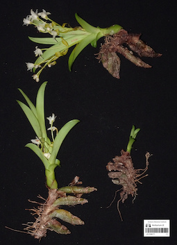
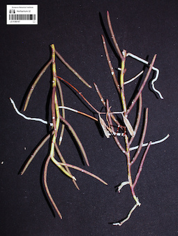
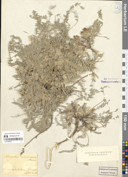
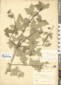
LE 01360171
Eria acervata Lindl. det. Averyanov, Leonid Vladimirovich at 04.04.2026
Collectors: Averyanov, Leonid Vladimirovich; Nguyen Van Canh; Truong Ba Vuong; Nguyen Quoc Bao; Maisak, Tatiana Viktorovna Field collecting number: AL4726. Collection date: 04.04.2026. Administrative regions: VN - Gia Lai. Groups of specimens: L. V. Averyanov specimens; L. V. Averyanov photos; Flora of VietnamOriginal label text:FLORA OF VIETNAM
Orchidaceae
Eria acervata Lindl.
Gia Lai Province, Mang Yang District, Ayune Commune, Kon Ka Kinh National Park. Secondary and primary dry evergreen broad-leaved forest on shale and lava rocks at elevation of 900-1000 m a.s.l. around point 14º13N 108º20E. Clustering epiphyte on tall tree. Flowers white. Common.
4 April 2026, L. Averyanov, Nguyen Van Canh, Truong Ba Vuong, Nguyen Quoc Bao, T. Maisak, АL4726.
All photos © - L. Averyanov
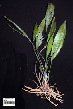
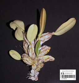
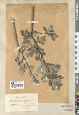
LE 01360170
Peliosanthes sp. det. Averyanov, Leonid Vladimirovich at 03.04.2026
Collectors: Averyanov, Leonid Vladimirovich; Nguyen Van Canh; Truong Ba Vuong; Nguyen Quoc Bao; Maisak, Tatiana Viktorovna Field collecting number: AL4725. Collection date: 03.04.2026. Administrative regions: VN - Gia Lai. Groups of specimens: L. V. Averyanov specimens; L. V. Averyanov photos; Flora of VietnamOriginal label text:FLORA OF VIETNAM
Convallariaceae
Peliosanthes sp.
Gia Lai Province, Mang Yang District, Ayune Commune, Kon Ka Kinh National Park. Secondary and primary dry evergreen broad-leaved forest on shale and lava rocks at elevation of 900-1000 m a.s.l. around point 14º13N 108º20E. Terrestrial herb in shady place along small stream. Occasional.
3 April 2026, L. Averyanov, Nguyen Van Canh, Truong Ba Vuong, Nguyen Quoc Bao, T. Maisak, АL4725 (living plant only).
All photos © - L. Averyanov
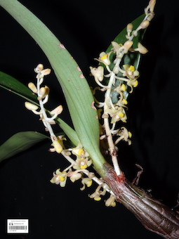
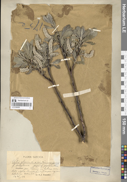
LE 01360169
Eria eriopsidobulbon C.S.P.Parish & Rchb.f. det. Averyanov, Leonid Vladimirovich at 08.07.2026
Additional identifications: Eria sp. det. Averyanov, Leonid Vladimirovich at 03.04.2026 Collectors: Averyanov, Leonid Vladimirovich; Nguyen Van Canh; Truong Ba Vuong; Nguyen Quoc Bao; Maisak, Tatiana Viktorovna Field collecting number: AL4724. Collection date: 03.04.2026. Administrative regions: VN - Gia Lai. Groups of specimens: L. V. Averyanov specimens; L. V. Averyanov photos; Flora of VietnamOriginal label text:FLORA OF VIETNAM
Orchidaceae
Eria eriopsidobulbon C.S.P.Parish & Rchb.f.
Gia Lai Province, Mang Yang District, Ayune Commune, Kon Ka Kinh National Park. Secondary and primary dry evergreen broad-leaved forest on shale and lava rocks at elevation of 900-1000 m a.s.l. around point 14º13N 108º20E. Clustering epiphyte on tall tree. Common.
3 April 2026, L. Averyanov, Nguyen Van Canh, Truong Ba Vuong, Nguyen Quoc Bao, T. Maisak, АL4724.
All photos © - L. Averyanov
LE 01360168
Bulbophyllum clandestinum Lindl. det. Averyanov, Leonid Vladimirovich at 03.04.2026
Collectors: Averyanov, Leonid Vladimirovich; Nguyen Van Canh; Truong Ba Vuong; Nguyen Quoc Bao; Maisak, Tatiana Viktorovna Field collecting number: AL4723. Collection date: 03.04.2026. Administrative regions: VN - Gia Lai. Groups of specimens: L. V. Averyanov specimens; L. V. Averyanov photos; Flora of VietnamOriginal label text:FLORA OF VIETNAM
Orchidaceae
Bulbophyllum clandestinum Lindl.
Gia Lai Province, Mang Yang District, Ayune Commune, Kon Ka Kinh National Park. Secondary and primary dry evergreen broad-leaved forest on shale and lava rocks at elevation of 900-1000 m a.s.l. around point 14º13N 108º20E. Clustering epiphyte on tall tree. Occasional.
3 April 2026, L. Averyanov, Nguyen Van Canh, Truong Ba Vuong, Nguyen Quoc Bao, T. Maisak, АL4723.
All photos © - L. Averyanov
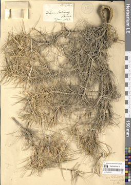
LE 01360167
Cleisostoma simondii (Gagnep.) Seidenf. det. Averyanov, Leonid Vladimirovich at 03.04.2026
Collectors: Averyanov, Leonid Vladimirovich; Nguyen Van Canh; Truong Ba Vuong; Nguyen Quoc Bao; Maisak, Tatiana Viktorovna Field collecting number: AL4722. Collection date: 03.04.2026. Administrative regions: VN - Gia Lai. Groups of specimens: L. V. Averyanov specimens; L. V. Averyanov photos; Flora of VietnamOriginal label text:FLORA OF VIETNAM
Orchidaceae
Cleisostoma simondii (Gagnep.) Seidenf.
Gia Lai Province, Mang Yang District, Ayune Commune, Kon Ka Kinh National Park. Secondary and primary dry evergreen broad-leaved forest on shale and lava rocks at elevation of 900-1000 m a.s.l. around point 14º13N 108º20E. Erect monopodial epiphyte on tall tree. Occasional.
3 April 2026, L. Averyanov, Nguyen Van Canh, Truong Ba Vuong, Nguyen Quoc Bao, T. Maisak, АL4722.
All photos © - L. Averyanov
LE 01360166
Dendrobium lindleyi Steud. det. Averyanov, Leonid Vladimirovich at 03.04.2026
Collectors: Averyanov, Leonid Vladimirovich; Nguyen Van Canh; Truong Ba Vuong; Nguyen Quoc Bao; Maisak, Tatiana Viktorovna Field collecting number: AL4721. Collection date: 03.04.2026. Administrative regions: VN - Gia Lai. Groups of specimens: L. V. Averyanov specimens; L. V. Averyanov photos; Flora of VietnamOriginal label text:FLORA OF VIETNAM
Orchidaceae
Dendrobium lindleyi Steud.
Gia Lai Province, Mang Yang District, Ayune Commune, Kon Ka Kinh National Park. Secondary and primary dry evergreen broad-leaved forest on shale and lava rocks at elevation of 900-1000 m a.s.l. around point 14º13N 108º20E. Clustering epiphyte on tall tree. Common.
3 April 2026, L. Averyanov, Nguyen Van Canh, Truong Ba Vuong, Nguyen Quoc Bao, T. Maisak, АL4721.
All photos © - L. Averyanov
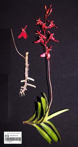
LE 01360165
Renanthera imschootiana Rolfe det. Averyanov, Leonid Vladimirovich at 03.04.2026
Collectors: Averyanov, Leonid Vladimirovich; Nguyen Van Canh; Truong Ba Vuong; Nguyen Quoc Bao; Maisak, Tatiana Viktorovna Field collecting number: AL4720. Collection date: 03.04.2026. Administrative regions: VN - Gia Lai. Groups of specimens: L. V. Averyanov specimens; L. V. Averyanov photos; Flora of VietnamOriginal label text:FLORA OF VIETNAM
Orchidaceae
Renanthera imschootiana Rolfe
Gia Lai Province, Mang Yang District, Ayune Commune, Kon Ka Kinh National Park. Secondary and primary dry evergreen broad-leaved forest on shale and lava rocks at elevation of 900-1000 m a.s.l. around point 14º13N 108º20E. Ascending monopodial epiphyte on tall tree. Flowers bright red. Not common.
3 April 2026, L. Averyanov, Nguyen Van Canh, Truong Ba Vuong, Nguyen Quoc Bao, T. Maisak, АL4720.
All photos © - L. Averyanov
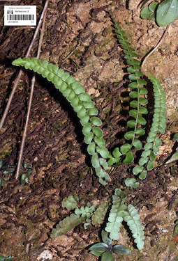
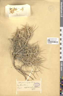
LE 01360164
Lindsaea orbiculata (Lam.) Mett. det. Averyanov, Leonid Vladimirovich at 03.04.2026
Collectors: Averyanov, Leonid Vladimirovich; Nguyen Van Canh; Truong Ba Vuong; Nguyen Quoc Bao; Maisak, Tatiana Viktorovna Field collecting number: AL4719a. Collection date: 03.04.2026. Administrative regions: VN - Gia Lai. Groups of specimens: L. V. Averyanov specimens; L. V. Averyanov photos; Flora of VietnamOriginal label text:FLORA OF VIETNAM
Polypodiaceae s.l. (Adiantaceae)
Lindsaea orbiculata (Lam.) Mett.
Gia Lai Province, Mang Yang District, Ayune Commune, Kon Ka Kinh National Park. Secondary and primary dry evergreen broad-leaved forest on shale and lava rocks at elevation of 900-1000 m a.s.l. around point 14º13N 108º20E. Terrestrial fern on roadcut of forest road in shady places. Very common.
3 April 2026, L. Averyanov, Nguyen Van Canh, Truong Ba Vuong, Nguyen Quoc Bao, T. Maisak, АL4719a (photo only).
All photos © - L. Averyanov
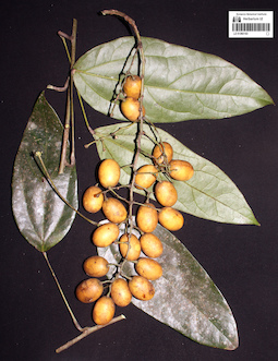
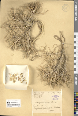
LE 01360163
Diploclisia glaucescens (Blume) Diels ⟮prelim. ID⟯ det. Averyanov, Leonid Vladimirovich at 03.04.2026
Collectors: Averyanov, Leonid Vladimirovich; Nguyen Van Canh; Truong Ba Vuong; Nguyen Quoc Bao; Maisak, Tatiana Viktorovna Field collecting number: AL4719. Collection date: 03.04.2026. Administrative regions: VN - Gia Lai. Groups of specimens: L. V. Averyanov specimens; L. V. Averyanov photos; Flora of VietnamOriginal label text:FLORA OF VIETNAM
Menispermaceae
Diploclisia glaucescens (Blume) Diels
Gia Lai Province, Mang Yang District, Ayune Commune, Kon Ka Kinh National Park. Secondary and primary dry evergreen broad-leaved forest on shale and lava rocks at elevation of 900-1000 m a.s.l. around point 14º13N 108º20E. Woody vine to 20 m long. Fruits dirty yellow, inside with white pulp with strong unpleasant smell. Not common.
3 April 2026, L. Averyanov, Nguyen Van Canh, Truong Ba Vuong, Nguyen Quoc Bao, T. Maisak, АL4719.
All photos © - L. Averyanov
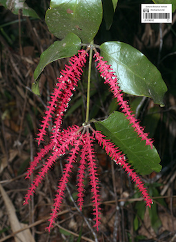
LE 01360162
Helixanthera coccinea (Jack) Danser det. Averyanov, Leonid Vladimirovich at 03.04.2026
Collectors: Averyanov, Leonid Vladimirovich; Nguyen Van Canh; Truong Ba Vuong; Nguyen Quoc Bao; Maisak, Tatiana Viktorovna Field collecting number: AL4718. Collection date: 03.04.2026. Administrative regions: VN - Gia Lai. Groups of specimens: L. V. Averyanov specimens; L. V. Averyanov photos; Flora of VietnamOriginal label text:FLORA OF VIETNAM
Lorantaceae
Helixanthera coccinea (Jack) Danser
Gia Lai Province, Mang Yang District, Ayune Commune, Kon Ka Kinh National Park. Secondary and primary dry evergreen broad-leaved forest on shale and lava rocks at elevation of 900-1000 m a.s.l. around point 14º13N 108º20E. Parasitic shrub in canopies of tall trees. Inflorescences bright red, petals white. Occasional.
3 April 2026, L. Averyanov, Nguyen Van Canh, Truong Ba Vuong, Nguyen Quoc Bao, T. Maisak, АL4718.
All photos © - L. Averyanov
LE 01360161
Harmandia mekongensis Baill. det. Averyanov, Leonid Vladimirovich at 03.06.2026
Collectors: Averyanov, Leonid Vladimirovich; Nguyen Van Canh; Truong Ba Vuong; Nguyen Quoc Bao; Maisak, Tatiana Viktorovna Field collecting number: AL4717. Collection date: 03.04.2026. Administrative regions: VN - Gia Lai. Groups of specimens: L. V. Averyanov specimens; L. V. Averyanov photos; Flora of VietnamOriginal label text:FLORA OF VIETNAM
Olacaceae
Harmandia mekongensis Baill.
Gia Lai Province, Mang Yang District, Ayune Commune, Kon Ka Kinh National Park. Secondary and primary dry evergreen broad-leaved forest on shale and lava rocks at elevation of 900-1000 m a.s.l. around point 14º13N 108º20E. Tree 4-5 m tall along forest trail. Calyx pink, fleshy. Rare.
3 April 2026, L. Averyanov, Nguyen Van Canh, Truong Ba Vuong, Nguyen Quoc Bao, T. Maisak, АL4717.
All photos © - L. Averyanov
LE 01360160
Pyrrosia sp. det. Averyanov, Leonid Vladimirovich, Nguyen Quoc Bao at 03.04.2026
Collectors: Averyanov, Leonid Vladimirovich; Nguyen Van Canh; Truong Ba Vuong; Nguyen Quoc Bao; Maisak, Tatiana Viktorovna Field collecting number: AL4716. Collection date: 03.04.2026. Administrative regions: VN - Gia Lai. Groups of specimens: L. V. Averyanov specimens; L. V. Averyanov photos; Flora of VietnamOriginal label text:FLORA OF VIETNAM
Polypodiaceae
Pyrrosia sp.
Gia Lai Province, Mang Yang District, Ayune Commune, Kon Ka Kinh National Park. Secondary and primary dry evergreen broad-leaved forest on shale and lava rocks at elevation of 900-1000 m a.s.l. around point 14º13N 108º20E. Creeping epiphyte on tall tree. Common.
3 April 2026, L. Averyanov, Nguyen Van Canh, Truong Ba Vuong, Nguyen Quoc Bao, T. Maisak, АL4716.
All photos © - L. Averyanov
LE 01360159
Stephania sp. det. Averyanov, Leonid Vladimirovich, Nguyen Quoc Bao at 03.04.2026
Collectors: Averyanov, Leonid Vladimirovich; Nguyen Van Canh; Truong Ba Vuong; Nguyen Quoc Bao; Maisak, Tatiana Viktorovna Field collecting number: AL4715. Collection date: 03.04.2026. Administrative regions: VN - Gia Lai. Groups of specimens: L. V. Averyanov specimens; L. V. Averyanov photos; Flora of VietnamOriginal label text:FLORA OF VIETNAM
Menispermaceae
Stephania sp.
Gia Lai Province, Mang Yang District, Ayune Commune, Kon Ka Kinh National Park. Secondary and primary dry evergreen broad-leaved forest on shale and lava rocks at elevation of 900-1000 m a.s.l. around point 14º13N 108º20E. Herbaceous vine 3-4 m long in open shrubs along road. Flowers yellowish. Common.
3 April 2026, L. Averyanov, Nguyen Van Canh, Truong Ba Vuong, Nguyen Quoc Bao, T. Maisak, АL4715.
All photos © - L. Averyanov
LE 01360158
Taenitis blechnoides (Willd.) Sw. det. Averyanov, Leonid Vladimirovich at 03.04.2026
Collectors: Averyanov, Leonid Vladimirovich; Nguyen Van Canh; Truong Ba Vuong; Nguyen Quoc Bao; Maisak, Tatiana Viktorovna Field collecting number: AL4714. Collection date: 03.04.2026. Administrative regions: VN - Gia Lai. Groups of specimens: L. V. Averyanov specimens; L. V. Averyanov photos; Flora of VietnamOriginal label text:FLORA OF VIETNAM
Polypodiaceae s.l. (Pteridaceae)
Taenitis blechnoides (Willd.) Sw.
Gia Lai Province, Mang Yang District, Ayune Commune, Kon Ka Kinh National Park. Secondary and primary dry evergreen broad-leaved forest on shale and lava rocks at elevation of 900-1000 m a.s.l. around point 14º13N 108º20E. Terrestrial fern with erect fronds to 0.6 m tall in shady place. Common.
3 April 2026, L. Averyanov, Nguyen Van Canh, Truong Ba Vuong, Nguyen Quoc Bao, T. Maisak, АL4714.
All photos © - L. Averyanov
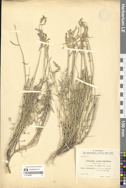
LE 01360353
Amorphophallus sp. det. Averyanov, Leonid Vladimirovich at 14.04.2026
Additional identifications: Epitype of Amorphophallus sp. ⟨sp.nov.?⟩ det. Hetterscheid, Wilbert Leonard Anna at 10.06.2026 Collectors: Averyanov, Leonid Vladimirovich; Nguyen Van Canh; Truong Ba Vuong; Maisak, Tatiana Viktorovna Field collecting number: AL4907. Collection date: 14.04.2026. Administrative regions: VN - Tinh Phu Yen. Groups of specimens: L. V. Averyanov specimens; L. V. Averyanov photos; Flora of VietnamOriginal label text:FLORA OF VIETNAM
Araceae
Amorphophallus sp.
Phu Yen Province, Tuy Hoa City, Hoa Xuan Commune. Highly degraded secondary evergreen broad-leaved dry forest with bamboo on very steep rocky mountain slope on granite at elevation of about 400 m a.s.l., around point 12º53’N 109º24’E (Bia Mountain). Terrestrial and lithophytic tuberiferous herb on shady rocky slope. Spathe and inflorescence apex white, flowers yellowish-brown. Odorless. Occasional.
14 April 2026, L. Averyanov, Nguyen Van Canh, Truong Ba Vuong, T. Maisak, АL4907.
All photos © - L. Averyanov & T.B. Vuong
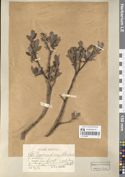
LE 01331133
Eruca sativa Mill. det. Pusyrev, Alexander Nikolaevich at 23.07.1990
Collectors: Pusyrev, Alexander Nikolaevich Collection date: 23.07.1990. Administrative regions: RU - Udmurtskaya Respublika - Izhevsk. Subregion: Ленинский район. Топоним: железнодорожная станция Ижевск-1, улица Дружбы, 16, Ижевск, Россия (Ижевск). Groups of specimens: Образцы сектора Восточной Европы; Гербарий Удмуртского Госуниверситета.Life form: therophyteOriginal label text:Удмуртская АССР, город Ижевск, железнодорожная станция Ижевск, между сортировочными железнодорожными путями.
Landscape in location of collection: граница южной тайги и подтайгиHabitat / plant community in location of collecting: между сортировочными железнодорожными путямиCoordinates (geographic position): 56° 48′ 7.52″ N, 53° 11′ 27.18″ ERecord creation: 2026-06-02, Denis Melnikov, PhotoScan D2Citation: Specimen LE 01331133 // Virtual herbarium of Komarov Botanical Institute RAS — http://re.herbariumle.ru/01331133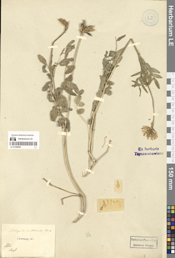
LE 01118394
Lepidium lasiocarpum Nutt. ex Torr & Gray det. Pusyrev, Alexander Nikolaevich at 30.09.1989
Collectors: Pusyrev, Alexander Nikolaevich Collection date: 30.09.1989. Administrative regions: RU - Udmurtskaya Respublika - Izhevsk. Subregion: Первомайский район. Топоним: Ижевский комбинат хлебопродуктов №1, улица Гольянский поселок (закрылся). Place of collection: во дворе комбината хлебопродуктов.Groups of specimens: Образцы сектора Восточной Европы; Гербарий Удмуртского Госуниверситета.Life form: therophyteOriginal label text:Удмуртская АССР, город Ижевск, Первомайский район, улица Гольянский посёлок, во дворе комбината хлебопродуктов. Пустырь, в бурьяне; на почве, усыпанной отходами зерноочистки.
Landscape in location of collection: граница южной тайги и подтайгиHabitat / plant community in location of collecting: пустырь, в бурьяне; на почве, усыпанной отходами зерноочисткиRecord creation: 2026-06-02, Denis Melnikov, PhotoScan D2Citation: Specimen LE 01118394 // Virtual herbarium of Komarov Botanical Institute RAS — http://re.herbariumle.ru/01118394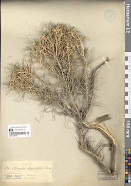
LE 01118391
Lepidium lasiocarpum Nutt. ex Torr & Gray det. Pusyrev, Alexander Nikolaevich at 11.09.1989
Collectors: Pusyrev, Alexander Nikolaevich Collection date: 11.09.1989. Administrative regions: RU - Udmurtskaya Respublika - Izhevsk. Subregion: Первомайский район. Топоним: Ижевский комбинат хлебопродуктов №1, улица Гольянский поселок (закрылся). Place of collection: во дворе комбината хлебопродуктов, между зданием элеватора и подъездным железнодорожным путём.Groups of specimens: Образцы сектора Восточной Европы; Гербарий Удмуртского Госуниверситета.Life form: therophyteOriginal label text:Удмуртская АССР, город Ижевск, Первомайский район, улица Гольянский посёлок, во дворе комбината хлебопродуктов. Между зданием элеватора и подъездным железнодорожным путём, на почве, усыпанной отходами зерноочистки.
Landscape in location of collection: граница южной тайги и подтайгиHabitat / plant community in location of collecting: на почве, усыпанной отходами зерноочисткиRecord creation: 2026-06-02, Denis Melnikov, PhotoScan D2Citation: Specimen LE 01118391 // Virtual herbarium of Komarov Botanical Institute RAS — http://re.herbariumle.ru/01118391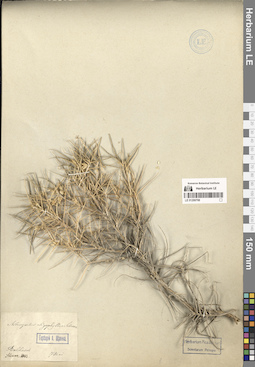
LE 01118386
Neslia paniculata (L.) Desv. det. Pusyrev, Alexander Nikolaevich at 01.07.2000
Collectors: Pusyrev, Alexander Nikolaevich Collection date: 01.07.2000. Administrative regions: RU - Udmurtskaya Respublika. Subregion: Малопургинский муниципальный округ (район). Топоним: деревня Бажаново, Удмуртия, Россия. Place of collection: северо-восточная окраина деревни Бажаново (4 километра севернее села Ильинское).Groups of specimens: Образцы сектора Восточной Европы; Гербарий Удмуртского Госуниверситета.Life form: therophyteObject features: часто, но не обильноOriginal label text:Удмуртская Республика, Малопургинский район, северо-восточная окраина деревни Бажаново (4 километра севернее села Ильинское). Поле ячменя двурядного. Часто, но не обильно.
Landscape in location of collection: подтайгаHabitat / plant community in location of collecting: поле ячменя двурядногоCoordinates (geographic position): 56° 31′ 31.68″ N, 52° 47′ 47.97″ ERecord creation: 2026-06-02, Denis Melnikov, PhotoScan D2Citation: Specimen LE 01118386 // Virtual herbarium of Komarov Botanical Institute RAS — http://re.herbariumle.ru/01118386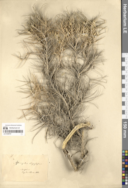
LE 01118379
Neslia paniculata (L.) Desv. det. Pusyrev, Alexander Nikolaevich at 28.06.2005
Collectors: Pusyrev, Alexander Nikolaevich Collection date: 28.06.2005. Administrative regions: RU - Udmurtskaya Respublika. Subregion: Граховский муниципальный округ (район). Place of collection: 4 километра восточнее деревни Лолошур-Возжи, 1 километр западнее деревни Благодатное (7-8 километров юго-западнее села Грахово).Groups of specimens: Образцы сектора Восточной Европы; Гербарий Удмуртского Госуниверситета.Life form: therophyteObject features: часто, цветет, плодоноситOriginal label text:Удмуртская Республика, Граховский район, 4 километра восточнее деревни Лолошур-Возжи, 1 километр западнее деревни Благодатное (7-8 километров юго-западнее села Грахово). Паровое поле, часто, цветёт, плодоносит.
Landscape in location of collection: граница подтайги и лесостепиHabitat / plant community in location of collecting: паровое полеCoordinates (geographic position): 55° 59′ 54.21″ N, 51° 50′ 29.86″ ERecord creation: 2026-06-02, Denis Melnikov, PhotoScan D2Citation: Specimen LE 01118379 // Virtual herbarium of Komarov Botanical Institute RAS — http://re.herbariumle.ru/01118379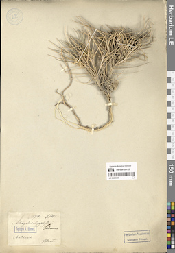
LE 01118367
Neslia apiculata Fisch. & C.A. Mey. det. Pusyrev, Alexander Nikolaevich at 21.07.1992
Collectors: Pusyrev, Alexander Nikolaevich Collection date: 21.07.1992. Administrative regions: RU - Udmurtskaya Respublika - Izhevsk. Subregion: Ленинский район. Топоним: железнодорожная станция Ижевск-1, улица Дружбы, 16, Ижевск, Россия (Ижевск). Place of collection: на подъездном железнодорожном пути к хлебоприёмному предприятию №2 (на картах отсутствует).Groups of specimens: Образцы сектора Восточной Европы; Гербарий Удмуртского Госуниверситета.Life form: therophyteObject features: 3 экземпляраOriginal label text:Удмуртская АССР, город Ижевск, Ленинский район, железнодорожная станция Ижевск. На подъездном железнодорожном пути к хлебоприёмному предприятию №2; 3 экземпляра
Landscape in location of collection: граница южной тайги и подтайгиCoordinates (geographic position): 56° 50′ 10.04″ N, 53° 14′ 36.59″ ERecord creation: 2026-06-02, Denis Melnikov, PhotoScan D2Citation: Specimen LE 01118367 // Virtual herbarium of Komarov Botanical Institute RAS — http://re.herbariumle.ru/01118367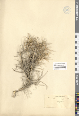
LE 01118349
Camelina rumelica Velen. det. Pusyrev, Alexander Nikolaevich at 25.06.1993
Collectors: Pusyrev, Alexander Nikolaevich Collection date: 25.06.1993. Administrative regions: RU - Udmurtskaya Respublika - Izhevsk. Subregion: Первомайский район. Топоним: Ижевский комбинат хлебопродуктов №1, улица Гольянский поселок (закрылся). Place of collection: во дворе комбината хлебопродуктов, близ здания элеватора.Groups of specimens: Образцы сектора Восточной Европы; Гербарий Удмуртского Госуниверситета.Life form: therophyteObject features: Лепестки белые!Original label text:Удмуртия, город Ижевск, во дворе комбината хлебопродуктов. На пустыре близ здания элеватора Лепестки белые! Первомайский район города Ижевска, улица Гольянский посёлок.
Landscape in location of collection: граница южной тайги и подтайгиHabitat / plant community in location of collecting: на пустыреCoordinates (geographic position): 56° 50′ 10.04″ N, 53° 14′ 36.59″ ERecord creation: 2026-06-02, Denis Melnikov, PhotoScan D2Citation: Specimen LE 01118349 // Virtual herbarium of Komarov Botanical Institute RAS — http://re.herbariumle.ru/01118349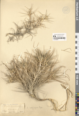
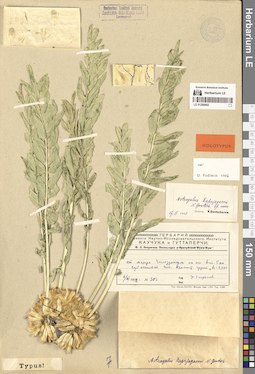
LE 01109460
Lepidium songaricum Schrenk ⟮prelim. ID⟯ det. illegible at 15.05.1962
Collectors: illegible Collection date: 15.05.1962. Administrative regions: RU - Orenburgskaya Oblast' - Novoorskiy Rayon. Groups of specimens: Образцы сектора Восточной Европы; Ленинградский ордена Ленина Государственный Университет имени А. А. Жданова Кафедра Ботанической ГеографииLife form: geophyteOriginal label text:Местонахождение: Оренбургская область Ново-Орский район
Landscape in location of collection: типчаково-ковыльные и типчаково-ковыльно-полынные степиHabitat / plant community in location of collecting: верхняя часть невысокого увала северо-западной экспозицииCoordinates (geographic position): 51° 26′ 7.76″ N, 59° 6′ 32.83″ ERecord creation: 2026-06-02, Denis Melnikov, PhotoScan D2Citation: Specimen LE 01109460 // Virtual herbarium of Komarov Botanical Institute RAS — http://re.herbariumle.ru/01109460Местообитание: Верхняя часть невысокого увала северо-западной экспозиции (далее нечитаемо)
LE 01108595
Neslia paniculata (L.) Desv. det. Pusyrev, Alexander Nikolaevich at 15.06.2006
Collectors: Pusyrev, Alexander Nikolaevich Collection date: 15.06.2006. Administrative regions: RU - Udmurtskaya Respublika. Subregion: Можгинский муниципальный округ (район). Топоним: Пычас - село в Можгинском районе Удмуртии. Place of collection: 0,5 километра южнее посёлка Пычас, близ свино-товарной фермы (на картах отсутствует).Groups of specimens: Образцы сектора Восточной Европы; Гербарий Удмуртского Госуниверситета.Life form: therophyteObject features: 15-20 экземпляровOriginal label text:Удмуртская Республика, Можгинский район, 0,5 километра южнее посёлка Пычас, близ свино-товарной фермы. На молодых залежах на месте бывших посадок картофеля. На одном из заброшенных участков, 15-20 экземпляров
Landscape in location of collection: подтайгаHabitat / plant community in location of collecting: на молодых залежах на месте бывших посадок картофеля, на одном из заброшенных участковCoordinates (geographic position): 56° 29′ 25.19″ N, 52° 26′ 6.68″ ERecord creation: 2026-06-02, Denis Melnikov, PhotoScan D2Citation: Specimen LE 01108595 // Virtual herbarium of Komarov Botanical Institute RAS — http://re.herbariumle.ru/01108595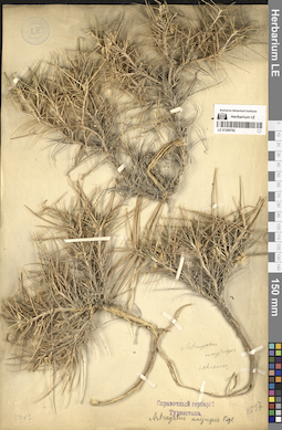
LE 01108594
Neslia paniculata (L.) Desv. det. Pusyrev, Alexander Nikolaevich at 30.09.2008
Collectors: Pusyrev, Alexander Nikolaevich Collection date: 30.09.2008. Administrative regions: RU - Udmurtskaya Respublika. Subregion: Сарапульский муниципальный округ (район). Топоним: шоссе 49Р-5 (Ижевск-Сарапул). Place of collection: 3,5 километра южнее деревни Девятово, 6 километров северо-западнее города Сарапул.Groups of specimens: Образцы сектора Восточной Европы; Гербарий Удмуртского Госуниверситета.Life form: therophyteObject features: изредкаOriginal label text:Удмуртская Республика, Сарапульский район, 3,5 километра южнее деревни Девятово, 6 километров северо-западнее города Сарапул. Откос насыпи недавно реконструированного участка шоссе Ижевск-Сарапул, изредка.
Landscape in location of collection: подтайгаHabitat / plant community in location of collecting: откос насыпи недавно реконструированного участка шоссеCoordinates (geographic position): 56° 31′ 10.49″ N, 53° 38′ 11.92″ ERecord creation: 2026-06-02, Denis Melnikov, PhotoScan D2Citation: Specimen LE 01108594 // Virtual herbarium of Komarov Botanical Institute RAS — http://re.herbariumle.ru/01108594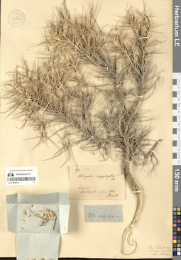
LE 01108593
Neslia paniculata (L.) Desv. det. Pusyrev, Alexander Nikolaevich at 10.07.2010
Collectors: Pusyrev, Alexander Nikolaevich Collection date: 10.07.2010. Administrative regions: RU - Udmurtskaya Respublika. Subregion: Юкаменский муниципальный округ (район). Топоним: деревня Жувам, Удмуртия, Россия. Place of collection: близ ограды двора средней школы.Groups of specimens: Образцы сектора Восточной Европы; Гербарий Удмуртского Госуниверситета.Life form: therophyteObject features: частоOriginal label text:Удмуртская Республика, Юкаменский район, юго-западная окраина деревни Жувам, близ ограды двора средней школы. На незасаженном ныне участке из-под картофеля, среди сорняков, часто. Почва дерново-карбонатная.
Landscape in location of collection: южная тайгаHabitat / plant community in location of collecting: на незасаженном ныне участке из-под картофеля, среди сорняков, почва дерново-карбонатнаяSubstrate in collecting location: rendzinaCoordinates (geographic position): 57° 49′ 7.27″ N, 52° 20′ 0.63″ ERecord creation: 2026-06-02, Denis Melnikov, PhotoScan D2Citation: Specimen LE 01108593 // Virtual herbarium of Komarov Botanical Institute RAS — http://re.herbariumle.ru/01108593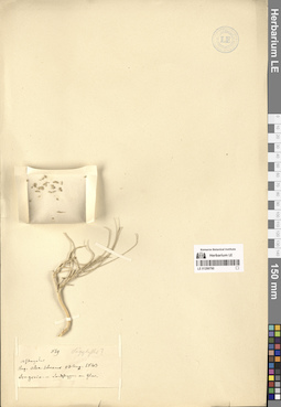
LE 01108588
Rorippa sylvestris (L.) Besser det. Pusyrev, Alexander Nikolaevich at 26.07.2019
Collectors: Pusyrev, Alexander Nikolaevich; Naumenko, Nikolai Ivanovich; Rubtsova, A. V.; Butolin, P. V. Collection date: 26.07.2019. Administrative regions: RU - Udmurtskaya Respublika. Subregion: Кезский муниципальный округ (район). Топоним: река Чепца, впадает в реку Вятка в городе Кирово-Чепецк, бассейн реки Кама. Place of collection: 1-1,5 километра юго-западнее деревни Гулейшур, 3 километра севернее поселка Поломское, пологий правый берег реки Чепца.Groups of specimens: Образцы сектора Восточной Европы; Гербарий Удмуртского Госуниверситета.Life form: geophyteObject features: частоOriginal label text:Удмуртская Республика, Кезский район, 1-1,5 километра юго-западнее деревни Гулейшур, 3 километра севернее поселка Поломское. Пологий правый берег реки Чепца, в прибрежной разреженной растительности, часто.
Landscape in location of collection: южная тайгаHabitat / plant community in location of collecting: в прибрежной разреженной растительностиCoordinates (geographic position): 57° 48′ 14.1″ N, 53° 22′ 41.89″ ERecord creation: 2026-06-02, Denis Melnikov, PhotoScan D2Citation: Specimen LE 01108588 // Virtual herbarium of Komarov Botanical Institute RAS — http://re.herbariumle.ru/01108588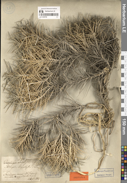
LE 01108580
Sisymbrium orientale L. det. Pusyrev, Alexander Nikolaevich at 28.08.1984
Additional identifications: Sisymbrium orientale L. det. Dorofeyev, V. I. Collectors: Pusyrev, Alexander Nikolaevich Collection date: 28.08.1984. Administrative regions: RU - Udmurtskaya Respublika - Izhevsk. Subregion: Ленинский район. Топоним: железнодорожная станция Ижевск-1, улица Дружбы, 16, Ижевск, Россия (Ижевск). Place of collection: 1 километр севернее железнодорожной станции Ижевск-1.Groups of specimens: Образцы сектора Восточной Европы; Гербарий Удмуртского Госуниверситета.Life form: therophyteOriginal label text:Удмуртская Республика, город Ижевск, Ленинский район, 1 километр севернее железнодорожной станции Ижевск. Железнодорожная насыпь.
Landscape in location of collection: граница южной тайги и подтайгиHabitat / plant community in location of collecting: железнодорожная насыпьCoordinates (geographic position): 56° 48′ 27.2″ N, 53° 11′ 29.09″ ERecord creation: 2026-06-02, Denis Melnikov, PhotoScan D2Citation: Specimen LE 01108580 // Virtual herbarium of Komarov Botanical Institute RAS — http://re.herbariumle.ru/01108580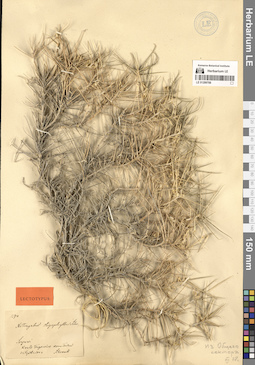
LE 01108578
Sisymbrium orientale L. det. Pusyrev, Alexander Nikolaevich at 24.09.1985
Additional identifications: Sisymbrium orientale L. det. Dorofeyev, V. I. Collectors: Pusyrev, Alexander Nikolaevich Collection date: 24.09.1985. Administrative regions: RU - Udmurtskaya Respublika - Izhevsk. Subregion: Ленинский район. Топоним: улица Пойма, Ижевск, Россия. Place of collection: во дворе хлебоприемного предприятия №2.Groups of specimens: Образцы сектора Восточной Европы; Гербарий Удмуртского Госуниверситета.Life form: therophyteOriginal label text:Удмуртская АССР, город Ижевск, Ленинский район, улица Пойма, во дворе хлебоприёмного предприятия №2. На подъездном железнодорожном пути.
Landscape in location of collection: граница южной тайги и подтайгиHabitat / plant community in location of collecting: на подъездном железнодорожном путиCoordinates (geographic position): 56° 47′ 56.56″ N, 53° 11′ 36.14″ ERecord creation: 2026-06-02, Denis Melnikov, PhotoScan D2Citation: Specimen LE 01108578 // Virtual herbarium of Komarov Botanical Institute RAS — http://re.herbariumle.ru/01108578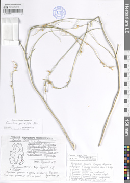
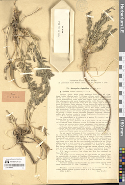
LE 01108570
Camelina grandiflora Boiss. det. Dorofeyev, V. I. at 07.01.2022
Additional identifications: Camelina laxa C.A. Mey. det. Pusyrev, Alexander Nikolaevich at 29.06.2020; Camelina hispida Boiss. ⟮s. l.⟯ det. German, Dmitrij Aleksandrovich at 14.11.2021 Collectors: Pusyrev, Alexander Nikolaevich Collection date: 29.06.1993. Administrative regions: RU - Udmurtskaya Respublika. Subregion: Сарапульский муниципальный округ (район). Топоним: Сарапул - город в Удмуртской респ.. Place of collection: во дворе крупозавода.Groups of specimens: Образцы сектора Восточной Европы; Гербарий Удмуртского Госуниверситета.Life form: therophyteObject features: сильное ветвление, длинные тонкие оси соцветий, длинные (до 3 миллиметров длиной) носики плодов, наличие в верхней части плодоножки булавовидного утолщения, слабая извилистость оси соцветия Носик плода длинный, до 2,5-3 миллиметров длины! один сильно ветвящийся экземплярOriginal label text:Удмуртская Республика, город Сарапул, во дворе крупозавода, пустырь. На свалке отходов зерноочистки. Один сильно ветвящийся экземпляр. Вероятно, занесено с зерном ячменя из Турции
Landscape in location of collection: подтайгаHabitat / plant community in location of collecting: пустырь, на свалке отходов зерноочисткиCoordinates (geographic position): 56° 27′ 40.38″ N, 53° 48′ 13.27″ ERecord creation: 2026-06-02, Denis Melnikov, PhotoScan D2Citation: Specimen LE 01108570 // Virtual herbarium of Komarov Botanical Institute RAS — http://re.herbariumle.ru/01108570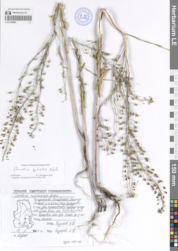
LE 01108569
Camelina sylvestris Wallr. det. Dorofeyev, V. I. at 07.01.2022
Additional identifications: Camelina microcarpa Andrz. det. Pusyrev, Alexander Nikolaevich at 19.06.2007 Collectors: Pusyrev, Alexander Nikolaevich Collection date: 19.06.2007. Administrative regions: RU - Udmurtskaya Respublika. Subregion: Малопургинский муниципальный округ (район). Топоним: деревня Сундуково, Удмуртия, Россия. Place of collection: 0,5 километра юго-западнее деревни Сундуково, 0,4 километра западнее остановочного пункта Сундуково (5 километров восточнее посёлка Кечёво); 1110,4 километра Горьковской железной дороги.Groups of specimens: Образцы сектора Восточной Европы; Гербарий Удмуртского Госуниверситета.Life form: therophyteObject features: обильноOriginal label text:Удмуртская Республика, Малопургинский район, 0,5 километра юго-западнее деревни Сундуково, 0,4 километра западнее остановочного пункта Сундуково (5 километров восточнее посёлка Кечёво); 1110,4 километра Горьковской железной дороги Откос железнодорожной насыпи, обильно.
Landscape in location of collection: подтайгаHabitat / plant community in location of collecting: откос железнодорожной насыпиCoordinates (geographic position): 56° 31′ 1.91″ N, 53° 18′ 18.13″ ERecord creation: 2026-06-02, Denis Melnikov, PhotoScan D2Citation: Specimen LE 01108569 // Virtual herbarium of Komarov Botanical Institute RAS — http://re.herbariumle.ru/01108569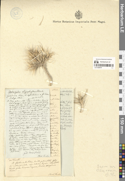
LE 01108568
Camelina sylvestris Wallr. det. Dorofeyev, V. I. at 07.01.2022
Additional identifications: Camelina microcarpa Andrz. det. Pusyrev, Alexander Nikolaevich at 04.06.2011 Collectors: Pusyrev, Alexander Nikolaevich Collection date: 04.06.2011. Administrative regions: RU - Udmurtskaya Respublika. Subregion: Завьяловский муницпальный округ (район). Топоним: деревня Новая Казмаска, Удмуртия, Россия. Place of collection: 0,5 километра северо-восточнее деревни Новая Казмаска.Groups of specimens: Образцы сектора Восточной Европы; Гербарий Удмуртского Госуниверситета.Life form: therophyteObject features: небольшие группы растенийOriginal label text:Удмуртская Республика, Завьяловский район, 0,5 километра северо-восточнее деревни Новая Казмаска. Сбитый суходольный луг на южном склоне к речке, вдоль скотобойных троп. Небольшие группы растений.
Landscape in location of collection: подтайгаHabitat / plant community in location of collecting: сбитый суходольный луг на южном склоне к речке, вдоль скотобойных тропCoordinates (geographic position): 56° 50′ 22″ N, 53° 32′ 22.54″ ERecord creation: 2026-06-02, Denis Melnikov, PhotoScan D2Citation: Specimen LE 01108568 // Virtual herbarium of Komarov Botanical Institute RAS — http://re.herbariumle.ru/01108568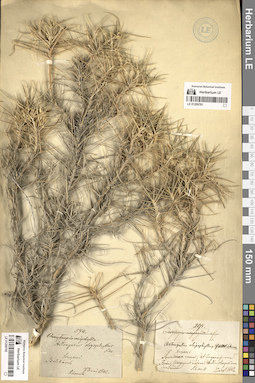
LE 01108480
Camelina sativa (L.) Crantz det. Pusyrev, Alexander Nikolaevich at 29.06.2020
Collectors: Pusyrev, Alexander Nikolaevich Collection date: 29.06.2020. Administrative regions: RU - Udmurtskaya Respublika - Izhevsk. Subregion: Индустриальный район. Топоним: улица 9 Января, Ижевск, Россия. Groups of specimens: Образцы сектора Восточной Европы; Гербарий Удмуртского Госуниверситета.Life form: therophyteObject features: Нижняя часть стебля и ветви густо опушены простыми и ветвистыми волосками! Три экземпляра в двух местах.Original label text:Удмуртская Республика, город Ижевск, Индустриальный район, улица 9-е Января, близ многоэтажного жилого дома Край газона у асфальтированного тротуара. В вытаптываемой растительности. Три экземпляра в двух местах.
Landscape in location of collection: граница южной тайги и подтайгиHabitat / plant community in location of collecting: близ многоэтажного жилого дома, край газона у асфальтированного тротуара, в вытаптываемой растительности.Coordinates (geographic position): 56° 52′ 45.04″ N, 53° 15′ 26.95″ ERecord creation: 2026-06-02, Denis Melnikov, PhotoScan D2Citation: Specimen LE 01108480 // Virtual herbarium of Komarov Botanical Institute RAS — http://re.herbariumle.ru/01108480Нижняя часть стебля и ветви густо опушены простыми и ветвистыми волосками!

LE 01108479
Camelina sylvestris Wallr. det. Pusyrev, Alexander Nikolaevich at 02.06.1984
Collectors: Pusyrev, Alexander Nikolaevich Collection date: 02.06.1984. Administrative regions: RU - Udmurtskaya Respublika. Subregion: Камбарский муниципальный округ (район). Топоним: Камбарка - город в Удмуртии. Place of collection: западный выход железнодорожной станции Камбарка, близ железнодорожного переезда.Groups of specimens: Образцы сектора Восточной Европы; Гербарий Удмуртского Госуниверситета.Life form: therophyteObject features: небольшая группа растенийOriginal label text:Удмуртская АССР, город Камбарка, западный выход железнодорожной станции Камбарка, близ железнодорожного переезда. Пустырь у откоса насыпи Горьковской железной дороги южной экспозиции Небольшая группа растений.
Landscape in location of collection: подтайгаHabitat / plant community in location of collecting: пустырь у откоса насыпи южной экспозицииCoordinates (geographic position): 56° 15′ 36.29″ N, 54° 13′ 41.69″ ERecord creation: 2026-06-02, Denis Melnikov, PhotoScan D2Citation: Specimen LE 01108479 // Virtual herbarium of Komarov Botanical Institute RAS — http://re.herbariumle.ru/01108479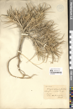
LE 01107599
Camelina alyssum (Mill.) Thell. det. Dorofeyev, V. I. at 07.01.2022
Additional identifications: Camelina linicola K.F. Schimp. & Spenn. det. Dorofeyev, V. I. at 16.12.2019 Collectors: Pusyrev, Alexander Nikolaevich; Larionov I. P. Collection date: 25.08.2018. Administrative regions: RU - Udmurtskaya Respublika. Subregion: Алнашский муниципальный округ (район). Топоним: деревня Азаматово, Удмуртия, Россия. Place of collection: 2 километра юго-западнее деревни Азаматово, 0,2 километра юго-западнее шоссе Алнаши-Варзи-Ятчи; 52,4 километра железной дороги Агрыз - Набережные Челны, 0,1 километра юго-западнее остановочной железнодорожной платформы.Groups of specimens: Образцы сектора Восточной Европы; Гербарий Удмуртского Госуниверситета.Life form: therophyteObject features: 3 цветущих плодоносящих экземпляраOriginal label text:Удмуртская Республика, Алнашский район, 2 километра юго-западнее деревни Азаматово, 0,2 километра юго-западнее шоссе Алнаши-Варзи-Ятчи; 52,4 километра железной дороги Агрыз - Набережные Челны, юго-восточная обочина железнодорожной насыпи, 3 цветущих плодоносящих экземпляра
Landscape in location of collection: подтайгаHabitat / plant community in location of collecting: юго-восточная обочина железнодорожной насыпиCoordinates (geographic position): 56° 10′ 51.51″ N, 52° 36′ 9.21″ ERecord creation: 2026-06-02, Denis Melnikov, PhotoScan D2Citation: Specimen LE 01107599 // Virtual herbarium of Komarov Botanical Institute RAS — http://re.herbariumle.ru/011075990,1 километра юго-западнее остановочной железнодорожной платформы
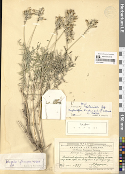
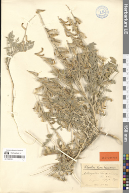
LE 01317786
Paratype of Prismatomeris konkakinhensis Bao, Vuong, V.C.Nguyen & Aver. det. Averyanov, Leonid Vladimirovich, Nguyen Quoc Bao at 02.06.2026
Collectors: Averyanov, Leonid Vladimirovich; Nguyen Van Canh; Truong Ba Vuong; Nguyen Quoc Bao; Maisak, Tatiana Viktorovna Field collecting number: AL4806. Collection date: 07.04.2026. Administrative regions: VN - Gia Lai. Groups of specimens: L. V. Averyanov specimens; L. V. Averyanov herbarium; Flora of VietnamOriginal label text:FLORA OF VIETNAM
Rubiaceae
Prismatomeris konkakinhensis Bao, Vuong, V.C.Nguyen & Aver.
Paratype
Gia Lai Province, K'Bang District. Highly degraded secondary evergreen broad-leaved dry forest at elevation 600-800 m a.s.l., around point 14º26N 108º22E. Treelet about 2.5 m tall in open place along stream. Flowers white. Occasional.
7 April 2026, L. Averyanov, Nguyen Van Canh, Truong Ba Vuong, Nguyen Quoc Bao, T. Maisak, АL4806.
LE 01317785
Paratype of Prismatomeris konkakinhensis Bao, Vuong, V.C.Nguyen & Aver. det. Averyanov, Leonid Vladimirovich, Nguyen Quoc Bao at 02.06.2026
Collectors: Averyanov, Leonid Vladimirovich; Nguyen Van Canh; Truong Ba Vuong; Nguyen Quoc Bao; Maisak, Tatiana Viktorovna Field collecting number: AL4828. Collection date: 08.04.2026. Administrative regions: VN - Gia Lai. Groups of specimens: L. V. Averyanov specimens; L. V. Averyanov herbarium; Flora of VietnamOriginal label text:FLORA OF VIETNAM
Rubiaceae
Prismatomeris konkakinhensis Bao, Vuong, V.C.Nguyen & Aver.
Paratype
Gia Lai Province, K'Bang District, Kon Bong Village, Kon Bong Waterfall. Highly degraded secondary evergreen broad-leaved dry forest on shale and lava rocks along river valley at elevation 800-900 m a.s.l., around point 14º30.5N 108º23E. Shrub or treelet to 3 m tall in open rocky river slope. Flowers white, fragrant. Occasional.
8 April 2026, L. Averyanov, Nguyen Van Canh, Truong Ba Vuong, Nguyen Quoc Bao, T. Maisak, АL4828.
LE 01360157
Pandanus sp. det. Averyanov, Leonid Vladimirovich at 03.04.2026
Collectors: Averyanov, Leonid Vladimirovich; Nguyen Van Canh; Truong Ba Vuong; Nguyen Quoc Bao; Maisak, Tatiana Viktorovna Field collecting number: AL4713. Collection date: 03.04.2026. Administrative regions: VN - Gia Lai. Groups of specimens: L. V. Averyanov specimens; L. V. Averyanov photos; Flora of VietnamOriginal label text:FLORA OF VIETNAM
Pandanaceae
Pandanus sp.
Gia Lai Province, Mang Yang District, Ayune Commune, Kon Ka Kinh National Park. Secondary and primary dry evergreen broad-leaved forest on shale and lava rocks at elevation of 900-1000 m a.s.l. around point 14º13N 108º20E. Palm-like few branching treelet to 4 m tall in shady wet place. Common.
3 April 2026, L. Averyanov, Nguyen Van Canh, Truong Ba Vuong, Nguyen Quoc Bao, T. Maisak, АL4713.
All photos © - L. Averyanov
LE 01360156
Ixora flexilis Pierre det. Nguyen Quoc Bao at 03.04.2026
Collectors: Averyanov, Leonid Vladimirovich; Nguyen Van Canh; Truong Ba Vuong; Nguyen Quoc Bao; Maisak, Tatiana Viktorovna Field collecting number: AL4712. Collection date: 03.04.2026. Administrative regions: VN - Gia Lai. Groups of specimens: L. V. Averyanov specimens; L. V. Averyanov photos; Flora of VietnamOriginal label text:FLORA OF VIETNAM
Rubiaceae
Ixora flexilis Pierre?
Gia Lai Province, Mang Yang District, Ayune Commune, Kon Ka Kinh National Park. Secondary and primary dry evergreen broad-leaved forest on shale and lava rocks at elevation of 900-1000 m a.s.l. around point 14º13N 108º20E. Shrub about 1.5 m tall. Flowers pinkish. Occasional.
3 April 2026, L. Averyanov, Nguyen Van Canh, Truong Ba Vuong, Nguyen Quoc Bao, T. Maisak, АL4712.
All photos © - L. Averyanov & N.Q. Bao
LE 01360155
Cibotium barometz (L.) J.Sm. det. Averyanov, Leonid Vladimirovich at 03.04.2026
Collectors: Averyanov, Leonid Vladimirovich; Nguyen Van Canh; Truong Ba Vuong; Nguyen Quoc Bao; Maisak, Tatiana Viktorovna Field collecting number: AL4711. Collection date: 03.04.2026. Administrative regions: VN - Gia Lai. Groups of specimens: L. V. Averyanov specimens; L. V. Averyanov photos; Flora of VietnamOriginal label text:FLORA OF VIETNAM
Polypodiaceae s.l. (Cyatheaceae)
Cibotium barometz (L.) J.Sm.
Gia Lai Province, Mang Yang District, Ayune Commune, Kon Ka Kinh National Park. Secondary and primary dry evergreen broad-leaved forest on shale and lava rocks at elevation of 900-1000 m a.s.l. around point 14º13N 108º20E. Terrestrial fern on shady roadcut of forest road. Fronds to 3 m long. Not rare.
3 April 2026, L. Averyanov, Nguyen Van Canh, Truong Ba Vuong, Nguyen Quoc Bao, T. Maisak, АL4711.
All photos © - L. Averyanov
LE 01360154
Schizaea digitata (L.) Sw. det. Averyanov, Leonid Vladimirovich at 03.04.2026
Collectors: Averyanov, Leonid Vladimirovich; Nguyen Van Canh; Truong Ba Vuong; Nguyen Quoc Bao; Maisak, Tatiana Viktorovna Field collecting number: AL4710. Collection date: 03.04.2026. Administrative regions: VN - Gia Lai. Groups of specimens: L. V. Averyanov specimens; L. V. Averyanov photos; Flora of VietnamOriginal label text:FLORA OF VIETNAM
Polypodiaceae s.l. (Schizaeaceae)
Schizaea digitata (L.) Sw.
Gia Lai Province, Mang Yang District, Ayune Commune, Kon Ka Kinh National Park. Secondary and primary dry evergreen broad-leaved forest on shale and lava rocks at elevation of 900-1000 m a.s.l. around point 14º13N 108º20E. Terrestrial clustering fern in shady place. Not common.
3 April 2026, L. Averyanov, Nguyen Van Canh, Truong Ba Vuong, Nguyen Quoc Bao, T. Maisak, АL4710.
All photos © - L. Averyanov
LE 01360153
Polystichum sp. ⟮prelim. ID⟯ det. Averyanov, Leonid Vladimirovich at 03.04.2026
Collectors: Averyanov, Leonid Vladimirovich; Nguyen Van Canh; Truong Ba Vuong; Nguyen Quoc Bao; Maisak, Tatiana Viktorovna Field collecting number: AL4709. Collection date: 03.04.2026. Administrative regions: VN - Gia Lai. Groups of specimens: L. V. Averyanov specimens; L. V. Averyanov photos; Flora of VietnamOriginal label text:FLORA OF VIETNAM
Polypodiaceae s.l.
Polystichum sp.
Gia Lai Province, Mang Yang District, Ayune Commune, Kon Ka Kinh National Park. Secondary and primary dry evergreen broad-leaved forest on shale and lava rocks at elevation of 900-1000 m a.s.l. around point 14º13N 108º20E. Terrestrial fern on steep stream slope in shady place. Common.
3 April 2026, L. Averyanov, Nguyen Van Canh, Truong Ba Vuong, Nguyen Quoc Bao, T. Maisak, АL4709.
All photos © - L. Averyanov
LE 01360152
Lindsaea javanensis Blume det. Averyanov, Leonid Vladimirovich at 03.04.2026
Collectors: Averyanov, Leonid Vladimirovich; Nguyen Van Canh; Truong Ba Vuong; Nguyen Quoc Bao; Maisak, Tatiana Viktorovna Field collecting number: AL4708. Collection date: 03.04.2026. Administrative regions: VN - Gia Lai. Groups of specimens: L. V. Averyanov specimens; L. V. Averyanov photos; Flora of VietnamOriginal label text:FLORA OF VIETNAM
Polypodiaceae s.l. (Adiantaceae)
Lindsaea javanensis Blume
Gia Lai Province, Mang Yang District, Ayune Commune, Kon Ka Kinh National Park. Secondary and primary dry evergreen broad-leaved forest on shale and lava rocks at elevation of 900-1000 m a.s.l. around point 14º13N 108º20E. Terrestrial fern in shady place along trail. Common.
3 April 2026, L. Averyanov, Nguyen Van Canh, Truong Ba Vuong, Nguyen Quoc Bao, T. Maisak, АL4708.
All photos © - L. Averyanov
LE 01360151
Hedyotis sp. det. Averyanov, Leonid Vladimirovich at 03.04.2026
Collectors: Averyanov, Leonid Vladimirovich; Nguyen Van Canh; Truong Ba Vuong; Nguyen Quoc Bao; Maisak, Tatiana Viktorovna Field collecting number: AL4707. Collection date: 03.04.2026. Administrative regions: VN - Gia Lai. Groups of specimens: L. V. Averyanov specimens; L. V. Averyanov photos; Flora of VietnamOriginal label text:FLORA OF VIETNAM
Rubiaceae
Hedyotis sp.
Gia Lai Province, Mang Yang District, Ayune Commune, Kon Ka Kinh National Park. Secondary and primary dry evergreen broad-leaved forest on shale and lava rocks at elevation of 900-1000 m a.s.l. around point 14º13N 108º20E. Erect herb to 1 m tall in open place along trail. Flowers white. Common.
3 April 2026, L. Averyanov, Nguyen Van Canh, Truong Ba Vuong, Nguyen Quoc Bao, T. Maisak, АL4707.
All photos © - L. Averyanov & N.Q. Bao
LE 01360150
Goniothalamus saccopetaloides Y.H.Tan & B.Yang det. Truong Ba Vuong at 03.04.2026
Collectors: Averyanov, Leonid Vladimirovich; Nguyen Van Canh; Truong Ba Vuong; Nguyen Quoc Bao; Maisak, Tatiana Viktorovna Field collecting number: AL4706. Collection date: 03.04.2026. Administrative regions: VN - Gia Lai. Groups of specimens: L. V. Averyanov specimens; L. V. Averyanov photos; Flora of VietnamOriginal label text:FLORA OF VIETNAM
Annonaceae
Goniothalamus saccopetaloides Y.H. Tan & Bin Yang
Gia Lai Province, Mang Yang District, Ayune Commune, Kon Ka Kinh National Park. Secondary and primary dry evergreen broad-leaved forest on shale and lava rocks at elevation of 900-1000 m a.s.l. around point 14º13N 108º20E. Small treelet or shrub in shady place. Flowers brownish-pink. Not common.
3 April 2026, L. Averyanov, Nguyen Van Canh, Truong Ba Vuong, Nguyen Quoc Bao, T. Maisak, АL4706.
All photos © - L. Averyanov & T.B. Vuong
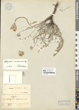
LE 01360149
Liparis pumila Aver. ⟮prelim. ID⟯ det. Averyanov, Leonid Vladimirovich at 02.04.2026
Collectors: Averyanov, Leonid Vladimirovich; Nguyen Van Canh; Truong Ba Vuong; Nguyen Quoc Bao; Maisak, Tatiana Viktorovna Field collecting number: AL4705. Collection date: 02.04.2026. Administrative regions: VN - Gia Lai. Groups of specimens: L. V. Averyanov specimens; L. V. Averyanov herbarium; Orchids of Vietnam, Laos and CambodiaOriginal label text:FLORA OF VIETNAM
Orchidaceae
Liparis pumila?
Gia Lai Province, Mang Yang District, Ayune Commune, Kon Ka Kinh National Park. Secondary and primary dry evergreen broad-leaved forest on shale and lava rocks at elevation of 900-1000 m a.s.l. around point 14º13N 108º20E. Clustering erect epiphytic undershrub on tall tree. Locally common.
2 April 2026, L. Averyanov, Nguyen Van Canh, Truong Ba Vuong, Nguyen Quoc Bao, T. Maisak, АL4705 (living plant only).
All photos © - L. Averyanov
LE 01360148
Aristolochia fordiana Hemsl. ⟮prelim. ID⟯ det. Truong Ba Vuong at 19.06.2026
Additional identifications: Aristolochia sp. det. Averyanov, Leonid Vladimirovich at 02.04.2026 Collectors: Averyanov, Leonid Vladimirovich; Nguyen Van Canh; Truong Ba Vuong; Nguyen Quoc Bao; Maisak, Tatiana Viktorovna Field collecting number: AL4704. Collection date: 02.04.2026. Administrative regions: VN - Gia Lai. Groups of specimens: L. V. Averyanov specimens; L. V. Averyanov photos; Flora of VietnamOriginal label text:FLORA OF VIETNAM
Aristolochiaceae
Aristolochia sp.
Gia Lai Province, Mang Yang District, Ayune Commune, Kon Ka Kinh National Park. Secondary and primary dry evergreen broad-leaved forest on shale and lava rocks at elevation of 900-1000 m a.s.l. around point 14º13N 108º20E. Herbaceous vine to 5 m long in open place. Flowers pale brown. Rare.
2 April 2026, L. Averyanov, Nguyen Van Canh, Truong Ba Vuong, Nguyen Quoc Bao, T. Maisak, АL4704.
All photos © - T.B. Vuong
LE 01360147
Aristolochia fordiana Hemsl. ⟮prelim. ID⟯ det. Truong Ba Vuong at 19.06.2026
Additional identifications: Aristolochia sp. det. Averyanov, Leonid Vladimirovich at 02.04.2026 Collectors: Averyanov, Leonid Vladimirovich; Nguyen Van Canh; Truong Ba Vuong; Nguyen Quoc Bao; Maisak, Tatiana Viktorovna Field collecting number: AL4704. Collection date: 02.04.2026. Administrative regions: VN - Gia Lai. Groups of specimens: L. V. Averyanov specimens; L. V. Averyanov photos; Flora of VietnamOriginal label text:FLORA OF VIETNAM
Aristolochiaceae
Aristolochia sp.
Gia Lai Province, Mang Yang District, Ayune Commune, Kon Ka Kinh National Park. Secondary and primary dry evergreen broad-leaved forest on shale and lava rocks at elevation of 900-1000 m a.s.l. around point 14º13N 108º20E. Herbaceous vine to 5 m long in open place. Flowers pale brown. Rare.
2 April 2026, L. Averyanov, Nguyen Van Canh, Truong Ba Vuong, Nguyen Quoc Bao, T. Maisak, АL4704.
All photos © - L. Averyanov
LE 01360146
Aspidistra globosa Vislobokov & Nuraliev det. Averyanov, Leonid Vladimirovich at 02.04.2026
Collectors: Averyanov, Leonid Vladimirovich; Nguyen Van Canh; Truong Ba Vuong; Nguyen Quoc Bao; Maisak, Tatiana Viktorovna Field collecting number: AL4703. Collection date: 02.04.2026. Administrative regions: VN - Gia Lai. Groups of specimens: L. V. Averyanov specimens; L. V. Averyanov photos; Flora of VietnamOriginal label text:FLORA OF VIETNAM
Convallariaceae
Aspidistra globosa Vislobokov & Nuraliev
Gia Lai Province, Mang Yang District, Ayune Commune, Kon Ka Kinh National Park. Secondary and primary dry evergreen broad-leaved forest on shale and lava rocks at elevation of 900-1000 m a.s.l. around point 14º13N 108º20E. Terrestrial herb with erect stem and numerous stilt roots on shady stream slope. Flowers pale green, inside dark violet. Locally abundant.
2 April 2026, L. Averyanov, Nguyen Van Canh, Truong Ba Vuong, Nguyen Quoc Bao, T. Maisak, АL4703.
All photos © - L. Averyanov
LE 01360145
Flickingeria fimbriata (Blume) A.D.Hawkes det. Averyanov, Leonid Vladimirovich at 02.04.2026
Collectors: Averyanov, Leonid Vladimirovich; Nguyen Van Canh; Truong Ba Vuong; Nguyen Quoc Bao; Maisak, Tatiana Viktorovna Field collecting number: AL4702. Collection date: 02.04.2026. Administrative regions: VN - Gia Lai. Groups of specimens: L. V. Averyanov specimens; L. V. Averyanov photos; Orchids of Vietnam, Laos and CambodiaOriginal label text:FLORA OF VIETNAM
Orchidaceae
Flickingeria fimbriata
Gia Lai Province, Mang Yang District, Ayune Commune, Kon Ka Kinh National Park. Secondary and primary dry evergreen broad-leaved forest on shale and lava rocks at elevation of 900-1000 m a.s.l. around point 14º13N 108º20E. Clustering erect epiphytic undershrub on tall tree. Locally common.
2 April 2026, L. Averyanov, Nguyen Van Canh, Truong Ba Vuong, Nguyen Quoc Bao, T. Maisak, АL4702.
All photos © - L. Averyanov