View
Add
Copy
Edit
Delete
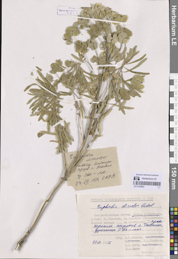
LE 01335956
Euphorbia discolor Ledeb. det. Jurtzev, Boris Alexandrovich
Collectors: Jurtzev, Boris Alexandrovich Administrative regions: RU - Respublika Sakha (Yakutiya) - Eveno-Bytantaysky National District. Groups of specimens: Образцы сектора Сибири и Дальнего Востока РоссииRecord creation: 2026-07-14, Marina Yarichina, PhotoScan D2Citation: Specimen LE 01335956 // Virtual herbarium of Komarov Botanical Institute RAS — http://re.herbariumle.ru/01335956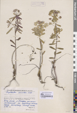
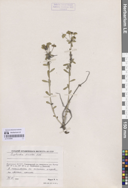
LE 01335955
Euphorbia discolor Ledeb. det. Jurtzev, Boris Alexandrovich
Collectors: Jurtzev, Boris Alexandrovich Administrative regions: RU - Respublika Sakha (Yakutiya) - Eveno-Bytantaysky National District. Groups of specimens: Образцы сектора Сибири и Дальнего Востока РоссииCoordinates (geographic position): 68° 9′ 48.01″ N, 131° 43′ 44.85″ E ±500 mRecord creation: 2026-07-14, Marina Yarichina, PhotoScan D2Citation: Specimen LE 01335955 // Virtual herbarium of Komarov Botanical Institute RAS — http://re.herbariumle.ru/01335955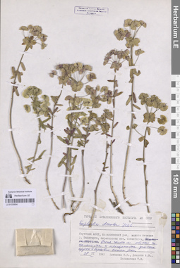
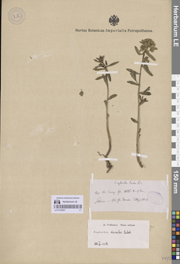
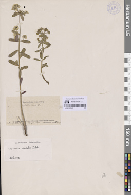
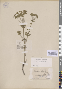
LE 01335954
Euphorbia discolor Ledeb. det. Koroleva (Zaslavskaya), Tatiana
Collectors: Antonova, Nina Nikolaevna; Denisov, A.V.; Koroleva (Zaslavskaya), Tatiana Administrative regions: RU - Respublika Sakha (Yakutiya). Subregion: Аллаиховский улус. Groups of specimens: Образцы сектора Сибири и Дальнего Востока РоссииCoordinates (geographic position): 69° 48′ 16.36″ N, 147° 29′ 36.98″ E ±1000 mRecord creation: 2026-07-14, Marina Yarichina, PhotoScan D2Citation: Specimen LE 01335954 // Virtual herbarium of Komarov Botanical Institute RAS — http://re.herbariumle.ru/01335954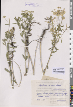
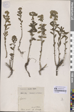
LE 01335953
Euphorbia discolor Ledeb.
Collectors: Razzhivin, Vladimir Yurievich Administrative regions: RU - Respublika Sakha (Yakutiya) - Oymyakonskiy District. Groups of specimens: Образцы сектора Сибири и Дальнего Востока РоссииCoordinates (geographic position): 64° 41′ 20.19″ N, 143° 19′ 0.51″ E ±1000 mRecord creation: 2026-07-14, Marina Yarichina, PhotoScan D2Citation: Specimen LE 01335953 // Virtual herbarium of Komarov Botanical Institute RAS — http://re.herbariumle.ru/01335953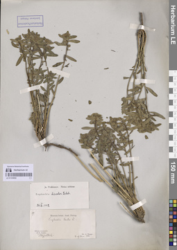
LE 01335952
Euphorbia discolor Ledeb. det. Prokhanov, Yaroslav Ivanovich
Additional identifications: Euphorbia esula L. det. Trautvetter, Rudolf Ernst von Collectors: Bunge, Alexander Alexandrovich Field collecting number: 19. Collection date: 09.06.1885. Administrative regions: RU - Respublika Sakha (Yakutiya) - Verkhoyansky District. Place of collection: гора Тылбыяхтах.Groups of specimens: Образцы сектора Сибири и Дальнего Востока РоссииOriginal label text:Sibiria orientalis: ad fl. Janam.
Coordinates (geographic position): 67° 37′ 8.73″ N, 133° 34′ 13.44″ E ±500 mRecord creation: 2026-07-14, Marina Yarichina, PhotoScan D2Citation: Specimen LE 01335952 // Virtual herbarium of Komarov Botanical Institute RAS — http://re.herbariumle.ru/01335952Tölbyjachtach
LE 01335951
Euphorbia discolor Ledeb. det. Prokhanov, Yaroslav Ivanovich
Additional identifications: Euphorbia esula L. det. Trautvetter, Rudolf Ernst von Collectors: Bunge, Alexander Alexandrovich Collection date: 09.06.1885. Administrative regions: RU - Respublika Sakha (Yakutiya) - Verkhoyansky District. Place of collection: гора Тылбыяхтах.Groups of specimens: Образцы сектора Сибири и Дальнего Востока РоссииOriginal label text:Sibiria - ad fl. Jana. Toldyjachtach
Coordinates (geographic position): 67° 37′ 7.55″ N, 133° 33′ 51.19″ E ±500 mRecord creation: 2026-07-14, Marina Yarichina, PhotoScan D2Citation: Specimen LE 01335951 // Virtual herbarium of Komarov Botanical Institute RAS — http://re.herbariumle.ru/01335951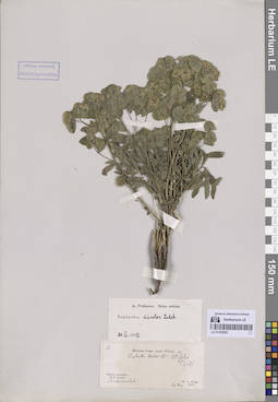
LE 01335950
Euphorbia discolor Ledeb. det. Prokhanov, Yaroslav Ivanovich
Additional identifications: Euphorbia esula L. det. Trautvetter, Rudolf Ernst von Collectors: Bunge, Alexander Alexandrovich Field collecting number: 13. Collection date: 20.06.1885. Administrative regions: RU - Respublika Sakha (Yakutiya) - Verkhoyansky District. Groups of specimens: Образцы сектора Сибири и Дальнего Востока РоссииOriginal label text:Sibiria orientalis: ad fl. Janam. Chaibankalach
Record creation: 2026-07-14, Marina Yarichina, PhotoScan D2Citation: Specimen LE 01335950 // Virtual herbarium of Komarov Botanical Institute RAS — http://re.herbariumle.ru/01335950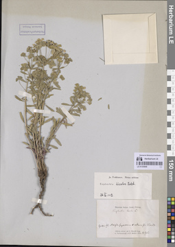
LE 01335949
Euphorbia discolor Ledeb. det. Prokhanov, Yaroslav Ivanovich
Additional identifications: Euphorbia esula L. det. Trautvetter, Rudolf Ernst von Collectors: Czekanowski, Alexander Piotr; Müller (Mueller), Ferdinand Ferdinandovich Collection date: 12.07.1874. Administrative regions: RU - Respublika Sakha (Yakutiya) - Olenyoksky District. Топоним: Maigda superiorem (река Верхние Монди). Place of collection: Оленек между устьями рр. В. Монди и Алакит.Groups of specimens: Образцы сектора Сибири и Дальнего Востока РоссииOriginal label text:Sibiria orientalis ad fl. Olenek. Inter fl. Maigda superiorem et ostium fl. Alakit
Coordinates (geographic position): 67° 8′ 3.91″ N, 109° 40′ 20.02″ E ±2000 mRecord creation: 2026-07-14, Marina Yarichina, PhotoScan D2Citation: Specimen LE 01335949 // Virtual herbarium of Komarov Botanical Institute RAS — http://re.herbariumle.ru/01335949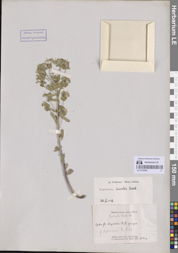
LE 01335948
Euphorbia discolor Ledeb. det. Prokhanov, Yaroslav Ivanovich
Additional identifications: Euphorbia esula L. det. Trautvetter, Rudolf Ernst von Collectors: Czekanowski, Alexander Piotr; Müller (Mueller), Ferdinand Ferdinandovich Collection date: 08.08.1874. Administrative regions: RU - Respublika Sakha (Yakutiya) - Olenyoksky District. Groups of specimens: Образцы сектора Сибири и Дальнего Востока РоссииOriginal label text:Sibiria orientalis ad fl. Olenek
Coordinates (geographic position): 68° 31′ 44.45″ N, 112° 13′ 50.08″ E ±2000 mRecord creation: 2026-07-14, Marina Yarichina, PhotoScan D2Citation: Specimen LE 01335948 // Virtual herbarium of Komarov Botanical Institute RAS — http://re.herbariumle.ru/01335948Inter fl. Argassala et fl. Gaingna
у ночлега 8 авг.
LE 01335947
Euphorbia discolor Ledeb. det. Prokhanov, Yaroslav Ivanovich
Additional identifications: Euphorbia esula L. det. Trautvetter, Rudolf Ernst von Collectors: Czekanowski, Alexander Piotr Collection date: 14.06.1875. Administrative regions: RU - Respublika Sakha (Yakutiya). Subregion: Кобяйский улус. Groups of specimens: Образцы сектора Сибири и Дальнего Востока РоссииOriginal label text:Ad fluv. Lenam inferiorem, inter fl. Sitta et petram Longko-kaja
Coordinates (geographic position): 63° 58′ 34.54″ N, 127° 4′ 11.75″ E ±3000 mComment: координаты выставлены на устье р. Ситте
Record creation: 2026-07-14, Marina Yarichina, PhotoScan D2Citation: Specimen LE 01335947 // Virtual herbarium of Komarov Botanical Institute RAS — http://re.herbariumle.ru/01335947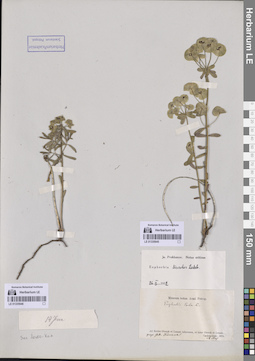
LE 01335945
Euphorbia discolor Ledeb. det. Prokhanov, Yaroslav Ivanovich
Additional identifications: Euphorbia esula L. det. Trautvetter, Rudolf Ernst von Collectors: Czekanowski, Alexander Piotr Collection date: 28.05.1875. Administrative regions: RU - Respublika Sakha (Yakutiya) - Olyokminsky District. Groups of specimens: Образцы сектора Сибири и Дальнего Востока РоссииOriginal label text:Ad fluvios Olenek et Lenam inferiores, et inter Olenek et Lenam, prope stat. Namana
Coordinates (geographic position): 60° 39′ 8.08″ N, 121° 11′ 31.42″ E ±500 mComment: станция Наманинская (Почтовая карта Азиатской России, 1871) в устье р. Намана; сейчас - с. Балаганнах
Record creation: 2026-07-14, Marina Yarichina, PhotoScan D2Citation: Specimen LE 01335945 // Virtual herbarium of Komarov Botanical Institute RAS — http://re.herbariumle.ru/01335945
LE 01335946
Euphorbia discolor Ledeb. det. Prokhanov, Yaroslav Ivanovich
Additional identifications: Euphorbia esula L. det. Trautvetter, Rudolf Ernst von Collectors: Czekanowski, Alexander Piotr Collection date: 14.06.1875. Administrative regions: RU - Respublika Sakha (Yakutiya). Subregion: Кобяйский улус. Groups of specimens: Образцы сектора Сибири и Дальнего Востока РоссииOriginal label text:Ad fluv. Lenam inferiorem, inter fl. Sitta et petram Longko-kaja
Coordinates (geographic position): 63° 58′ 34.54″ N, 127° 4′ 11.75″ E ±3000 mComment: координаты выставлены на устье р. Ситте
Record creation: 2026-07-14, Marina Yarichina, PhotoScan D2Citation: Specimen LE 01335946 // Virtual herbarium of Komarov Botanical Institute RAS — http://re.herbariumle.ru/01335946
LE 01335943
Euphorbia discolor Ledeb. det. Prokhanov, Yaroslav Ivanovich
Additional identifications: Euphorbia esula L. det. Trautvetter, Rudolf Ernst von Collectors: Czekanowski, Alexander Piotr Collection date: 03.07.1875. Administrative regions: RU - Respublika Sakha (Yakutiya) - Zhigansky District. Groups of specimens: Образцы сектора Сибири и Дальнего Востока РоссииOriginal label text:Ad fluv. Lenam inferiorem, ad fl. Tongus-Apata. 5 Julii
Coordinates (geographic position): 67° 1′ 2.34″ N, 123° 18′ 0.26″ E ±1000 mComment: Траутфеттер скорее всего неверно написал дату, и должно быть 3.07. Потому что 5 июля экспедиция была уже ниже - прошла реку Хоронко (Хоруонка).
Record creation: 2026-07-14, Marina Yarichina, PhotoScan D2Citation: Specimen LE 01335943 // Virtual herbarium of Komarov Botanical Institute RAS — http://re.herbariumle.ru/01335943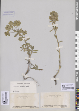
LE 01335944
Euphorbia discolor Ledeb. det. Prokhanov, Yaroslav Ivanovich
Additional identifications: Euphorbia esula L. det. Czekanowski, Alexander Piotr Collectors: Czekanowski, Alexander Piotr Collection date: 08.06.1875. Administrative regions: RU - Respublika Sakha (Yakutiya). Subregion: Намский улус. Place of collection: село Намцы.Groups of specimens: Образцы сектора Сибири и Дальнего Востока РоссииOriginal label text:Ad fluv. Lenam inferiorem, prope Namski-Uluss.
Coordinates (geographic position): 62° 43′ 12.74″ N, 129° 41′ 12.23″ E ±1000 mRecord creation: 2026-07-14, Marina Yarichina, PhotoScan D2Citation: Specimen LE 01335944 // Virtual herbarium of Komarov Botanical Institute RAS — http://re.herbariumle.ru/01335944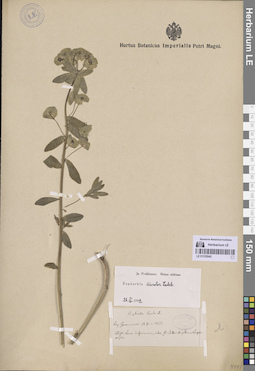
LE 01335942
Euphorbia discolor Ledeb. det. Prokhanov, Yaroslav Ivanovich
Additional identifications: Euphorbia esula L. det. Trautvetter, Rudolf Ernst von Collectors: Czekanowski, Alexander Piotr Collection date: 14.06.1875. Administrative regions: RU - Respublika Sakha (Yakutiya). Subregion: Кобяйский улус. Groups of specimens: Образцы сектора Сибири и Дальнего Востока РоссииOriginal label text:Ad fl. Lena inferiorem, inter fl. Sitta et petram Longko-kaja
Coordinates (geographic position): 64° 10′ 28.34″ N, 126° 41′ 49.49″ E ±1000 mRecord creation: 2026-07-14, Marina Yarichina, PhotoScan D2Citation: Specimen LE 01335942 // Virtual herbarium of Komarov Botanical Institute RAS — http://re.herbariumle.ru/01335942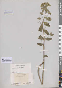
LE 01335941
Euphorbia discolor Ledeb. det. Prokhanov, Yaroslav Ivanovich
Additional identifications: Euphorbia esula L. det. Trautvetter, Rudolf Ernst von Collectors: Czekanowski, Alexander Piotr Collection date: 14.06.1875. Administrative regions: RU - Respublika Sakha (Yakutiya). Subregion: Кобяйский улус. Groups of specimens: Образцы сектора Сибири и Дальнего Востока РоссииOriginal label text:Ad fl. Lena inferiorem, inter fl. Sitta et petram Longko-kaja
Coordinates (geographic position): 64° 10′ 28.34″ N, 126° 41′ 49.49″ E ±500 mRecord creation: 2026-07-14, Marina Yarichina, PhotoScan D2Citation: Specimen LE 01335941 // Virtual herbarium of Komarov Botanical Institute RAS — http://re.herbariumle.ru/01335941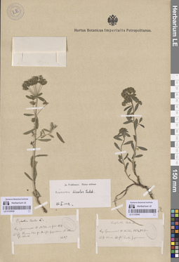
LE 01335939
Euphorbia discolor Ledeb. det. Prokhanov, Yaroslav Ivanovich
Additional identifications: Euphorbia esula L. det. Trautvetter, Rudolf Ernst von Collectors: Czekanowski, Alexander Piotr; Müller (Mueller), Ferdinand Ferdinandovich Field collecting number: 3687. Collection date: 12.07.1874. Administrative regions: RU - Respublika Sakha (Yakutiya) - Olenyoksky District. Топоним: Maigda superiorem (река Верхние Монди). Place of collection: Оленек между устьями рр. В. Монди и Алакит.Groups of specimens: Образцы сектора Сибири и Дальнего Востока РоссииOriginal label text:Ad fl. Olenek, inter fl. Maigda superiorem et ostium fl. Alakit
Coordinates (geographic position): 67° 8′ 11.21″ N, 109° 39′ 55.91″ E ±2000 mRecord creation: 2026-07-14, Marina Yarichina, PhotoScan D2Citation: Specimen LE 01335939 // Virtual herbarium of Komarov Botanical Institute RAS — http://re.herbariumle.ru/01335939
LE 01335940
Euphorbia discolor Ledeb. det. Prokhanov, Yaroslav Ivanovich
Additional identifications: Euphorbia esula L. det. Trautvetter, Rudolf Ernst von Collectors: Czekanowski, Alexander Piotr; Müller (Mueller), Ferdinand Ferdinandovich Collection date: 23.06.1874. Administrative regions: RU - Respublika Sakha (Yakutiya) - Olenyoksky District. Groups of specimens: Образцы сектора Сибири и Дальнего Востока РоссииOriginal label text:Ad fl. Olenek, ad fl. Tomba superiorem
Coordinates (geographic position): 66° 59′ 53.93″ N, 106° 33′ 15.26″ E ±2000 mRecord creation: 2026-07-14, Marina Yarichina, PhotoScan D2Citation: Specimen LE 01335940 // Virtual herbarium of Komarov Botanical Institute RAS — http://re.herbariumle.ru/01335940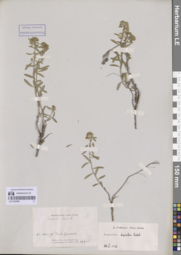
LE 01335938
Euphorbia discolor Ledeb. det. Prokhanov, Yaroslav Ivanovich
Additional identifications: Euphorbia esula L. det. Trautvetter, Rudolf Ernst von Collectors: Czekanowski, Alexander Piotr; Müller (Mueller), Ferdinand Ferdinandovich Collection date: 29.06.1874. Administrative regions: RU - Respublika Sakha (Yakutiya) - Olenyoksky District. Place of collection: на устье р. Верхняя Томба.Groups of specimens: Образцы сектора Сибири и Дальнего Востока РоссииOriginal label text:Sibiria orientalis ad fl. Olenek. Ad ostium Tomba superiorem
Coordinates (geographic position): 67° 18′ 9.21″ N, 106° 54′ 34.84″ E ±1000 mRecord creation: 2026-07-14, Marina Yarichina, PhotoScan D2Citation: Specimen LE 01335938 // Virtual herbarium of Komarov Botanical Institute RAS — http://re.herbariumle.ru/01335938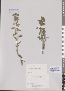
LE 01335937
Euphorbia discolor Ledeb. det. Prokhanov, Yaroslav Ivanovich
Additional identifications: Euphorbia esula L. det. Trautvetter, Rudolf Ernst von Collectors: Czekanowski, Alexander Piotr; Müller (Mueller), Ferdinand Ferdinandovich Collection date: 23.06.1874. Administrative regions: RU - Respublika Sakha (Yakutiya) - Olenyoksky District. Groups of specimens: Образцы сектора Сибири и Дальнего Востока РоссииOriginal label text:Sibiria orientalis ad fl. Olenek. Ad fl. Welingna
Coordinates (geographic position): 66° 58′ 38.15″ N, 106° 32′ 45.53″ E ±500 mRecord creation: 2026-07-14, Marina Yarichina, PhotoScan D2Citation: Specimen LE 01335937 // Virtual herbarium of Komarov Botanical Institute RAS — http://re.herbariumle.ru/01335937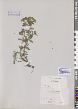
LE 01335936
Euphorbia discolor Ledeb. det. Prokhanov, Yaroslav Ivanovich
Additional identifications: Euphorbia esula L. det. Trautvetter, Rudolf Ernst von Collectors: Czekanowski, Alexander Piotr; Müller (Mueller), Ferdinand Ferdinandovich Collection date: 23.06.1874. Administrative regions: RU - Respublika Sakha (Yakutiya) - Olenyoksky District. Subregion: Верхняя Томба. Groups of specimens: Образцы сектора Сибири и Дальнего Востока РоссииOriginal label text:Sibiria orientalis ad fl. Olenek. Ad fl. Tomba superiorem
Coordinates (geographic position): 66° 59′ 24.26″ N, 106° 33′ 55.52″ E ±1000 mRecord creation: 2026-07-14, Marina Yarichina, PhotoScan D2Citation: Specimen LE 01335936 // Virtual herbarium of Komarov Botanical Institute RAS — http://re.herbariumle.ru/01335936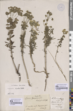
LE 01335934
Euphorbia discolor Ledeb. det. Prokhanov, Yaroslav Ivanovich
Additional identifications: Euphorbia esula L. Collectors: Stubendorff, Yuliy Ivanovich Field collecting number: 134. Collection date: 1849. Administrative regions: RU - Khabarovskiy Kray - Ayano-Mayskiy Rayon. Groups of specimens: Образцы сектора Сибири и Дальнего Востока РоссииOriginal label text:Ad fl. Maimakan
Record creation: 2026-07-14, Marina Yarichina, PhotoScan D2Citation: Specimen LE 01335934 // Virtual herbarium of Komarov Botanical Institute RAS — http://re.herbariumle.ru/01335934
LE 01335935
Euphorbia discolor Ledeb. det. Prokhanov, Yaroslav Ivanovich
Additional identifications: Euphorbia esula L. Collectors: Pavlowsky, Aleksander Petrovich Administrative regions: RU - Respublika Sakha (Yakutiya). Groups of specimens: Образцы сектора Сибири и Дальнего Востока РоссииOriginal label text:Sibiria orient. In montibus ad fl. Таркан.
Record creation: 2026-07-14, Marina Yarichina, PhotoScan D2Citation: Specimen LE 01335935 // Virtual herbarium of Komarov Botanical Institute RAS — http://re.herbariumle.ru/01335935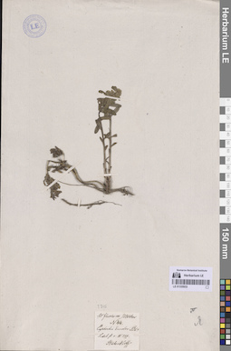
LE 01335933
Euphorbia discolor Ledeb.
Collectors: Stubendorff, Yuliy Ivanovich Field collecting number: 44. Collection date: 1849. Administrative regions: RU - Respublika Sakha (Yakutiya) - Aldanskiy Rayon. Groups of specimens: Образцы сектора Сибири и Дальнего Востока РоссииOriginal label text:Ad fluvium Utschur
Coordinates (geographic position): 58° 47′ 56.32″ N, 130° 39′ 18.82″ E ±1000 mRecord creation: 2026-07-14, Marina Yarichina, PhotoScan D2Citation: Specimen LE 01335933 // Virtual herbarium of Komarov Botanical Institute RAS — http://re.herbariumle.ru/01335933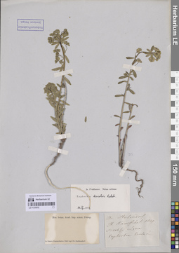
LE 01335932
Euphorbia discolor Ledeb. det. Prokhanov, Yaroslav Ivanovich
Collectors: Stubendorff, Yuliy Ivanovich Collection date: 17.05.1849. Administrative regions: RU - Respublika Sakha (Yakutiya). Groups of specimens: Образцы сектора Сибири и Дальнего Востока РоссииOriginal label text:In itinere Kamtschatico.
Record creation: 2026-07-14, Marina Yarichina, PhotoScan D2Citation: Specimen LE 01335932 // Virtual herbarium of Komarov Botanical Institute RAS — http://re.herbariumle.ru/01335932It. Kamtschat.
Lena
LE 01335931
Euphorbia discolor Ledeb. det. Prokhanov, Yaroslav Ivanovich
Additional identifications: Euphorbia esula L. det. Glehn, Peter von. Collectors: Poljakow, Ivan Semyonovich Field collecting number: 122. Collection date: 08.06.1866. Administrative regions: RU - Irkutskaya Oblast'. Groups of specimens: Образцы сектора Сибири и Дальнего Востока РоссииOriginal label text:Sibiria orientalis ad fl. Witim.
Record creation: 2026-07-14, Marina Yarichina, PhotoScan D2Citation: Specimen LE 01335931 // Virtual herbarium of Komarov Botanical Institute RAS — http://re.herbariumle.ru/01335931Долина р. ..., на песчаных каменистых берегах речки.
LE 01335930
Euphorbia discolor Ledeb. det. Prokhanov, Yaroslav Ivanovich
Collectors: Pavlowsky, Aleksander Petrovich Administrative regions: RU - Respublika Sakha (Yakutiya) - Aldanskiy Rayon. Groups of specimens: Образцы сектора Сибири и Дальнего Востока РоссииOriginal label text:Sibiria orient. Ad fl. Utschur.
Coordinates (geographic position): 58° 47′ 46.99″ N, 130° 39′ 33.43″ E ±1000 mRecord creation: 2026-07-14, Marina Yarichina, PhotoScan D2Citation: Specimen LE 01335930 // Virtual herbarium of Komarov Botanical Institute RAS — http://re.herbariumle.ru/01335930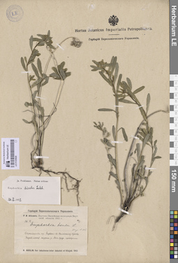
LE 01335929
Euphorbia discolor Ledeb. det. Prokhanov, Yaroslav Ivanovich
Additional identifications: Euphorbia esula L. det. Abolin, Robert Ivanovich Collectors: Abolin, Robert Ivanovich Administrative regions: RU - Respublika Sakha (Yakutiya). Groups of specimens: Образцы сектора Сибири и Дальнего Востока РоссииCoordinates (geographic position): 62° 3′ 40.63″ N, 129° 32′ 24.53″ E ±1000 mRecord creation: 2026-07-14, Marina Yarichina, PhotoScan D2Citation: Specimen LE 01335929 // Virtual herbarium of Komarov Botanical Institute RAS — http://re.herbariumle.ru/01335929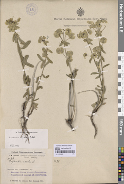
LE 01335928
Euphorbia discolor Ledeb. det. Prokhanov, Yaroslav Ivanovich
Additional identifications: Euphorbia esula L. Collectors: Dolenko, G. I. Administrative regions: RU - Respublika Sakha (Yakutiya) - Olyokminsky District. Groups of specimens: Образцы сектора Сибири и Дальнего Востока РоссииCoordinates (geographic position): 60° 22′ 52.7″ N, 120° 26′ 46.93″ E ±1000 mRecord creation: 2026-07-14, Marina Yarichina, PhotoScan D2Citation: Specimen LE 01335928 // Virtual herbarium of Komarov Botanical Institute RAS — http://re.herbariumle.ru/01335928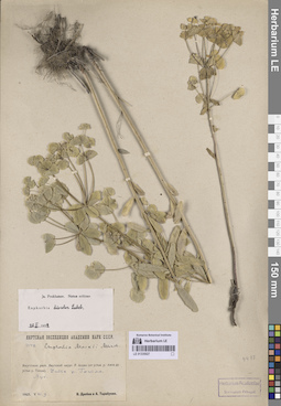
LE 01335927
Euphorbia discolor Ledeb. det. Prokhanov, Yaroslav Ivanovich
Additional identifications: Euphorbia maackii Meinsh. Collectors: Drobow, Vasilii Petrovich; Tarabukin, A.P. Administrative regions: RU - Respublika Sakha (Yakutiya). Groups of specimens: Образцы сектора Сибири и Дальнего Востока РоссииRecord creation: 2026-07-14, Marina Yarichina, PhotoScan D2Citation: Specimen LE 01335927 // Virtual herbarium of Komarov Botanical Institute RAS — http://re.herbariumle.ru/01335927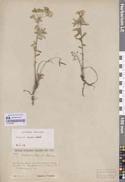
LE 01335926
Euphorbia discolor Ledeb. det. Prokhanov, Yaroslav Ivanovich
Additional identifications: Euphorbia maackii Meinsh. Collectors: Drobow, Vasilii Petrovich; Tarabukin, A.P. Administrative regions: RU - Respublika Sakha (Yakutiya). Groups of specimens: Образцы сектора Сибири и Дальнего Востока РоссииRecord creation: 2026-07-14, Marina Yarichina, PhotoScan D2Citation: Specimen LE 01335926 // Virtual herbarium of Komarov Botanical Institute RAS — http://re.herbariumle.ru/01335926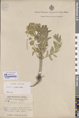
LE 01335925
Euphorbia discolor Ledeb. det. Prokhanov, Yaroslav Ivanovich
Additional identifications: Euphorbia esula L. Collectors: Drobow, Vasilii Petrovich Administrative regions: RU - Respublika Sakha (Yakutiya) - Vilyuysky District. Groups of specimens: Образцы сектора Сибири и Дальнего Востока РоссииRecord creation: 2026-07-14, Marina Yarichina, PhotoScan D2Citation: Specimen LE 01335925 // Virtual herbarium of Komarov Botanical Institute RAS — http://re.herbariumle.ru/01335925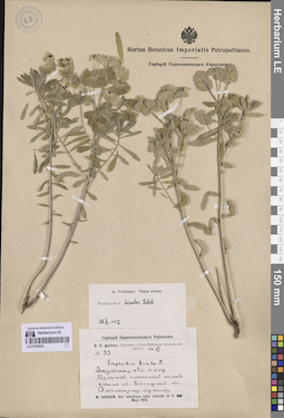
LE 01335924
Euphorbia discolor Ledeb. det. Prokhanov, Yaroslav Ivanovich
Additional identifications: Euphorbia esula L. Collectors: Drobow, Vasilii Petrovich Administrative regions: RU - Respublika Sakha (Yakutiya) - Amginskiy Rayon. Groups of specimens: Образцы сектора Сибири и Дальнего Востока России; Гербарий Переселенческого УправленияRecord creation: 2026-07-14, Marina Yarichina, PhotoScan D2Citation: Specimen LE 01335924 // Virtual herbarium of Komarov Botanical Institute RAS — http://re.herbariumle.ru/01335924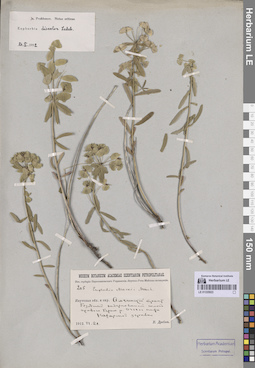
LE 01335923
Euphorbia discolor Ledeb. det. Prokhanov, Yaroslav Ivanovich
Additional identifications: Euphorbia maackii Meinsh. Collectors: Drobow, Vasilii Petrovich Administrative regions: RU - Respublika Sakha (Yakutiya) - Amginskiy Rayon. Groups of specimens: Образцы сектора Сибири и Дальнего Востока РоссииRecord creation: 2026-07-14, Marina Yarichina, PhotoScan D2Citation: Specimen LE 01335923 // Virtual herbarium of Komarov Botanical Institute RAS — http://re.herbariumle.ru/01335923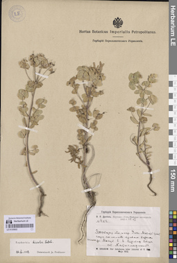
LE 01335922
Euphorbia discolor Ledeb. det. Prokhanov, Yaroslav Ivanovich
Collectors: Drobow, Vasilii Petrovich Administrative regions: RU - Respublika Sakha (Yakutiya) - Ust'-Mayskiy Rayon. Groups of specimens: Образцы сектора Сибири и Дальнего Востока РоссииRecord creation: 2026-07-14, Marina Yarichina, PhotoScan D2Citation: Specimen LE 01335922 // Virtual herbarium of Komarov Botanical Institute RAS — http://re.herbariumle.ru/01335922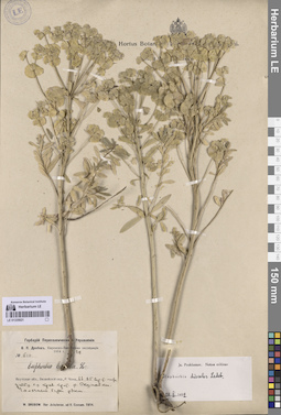
LE 01335921
Euphorbia discolor Ledeb. det. Prokhanov, Yaroslav Ivanovich
Collectors: Drobow, Vasilii Petrovich Administrative regions: RU - Respublika Sakha (Yakutiya). Subregion: Мирнинский район. Place of collection: р. Вакунайка.Groups of specimens: Образцы сектора Сибири и Дальнего Востока РоссииCoordinates (geographic position): 61° 44′ 25.75″ N, 109° 36′ 26.06″ E ±1000 mRecord creation: 2026-07-14, Marina Yarichina, PhotoScan D2Citation: Specimen LE 01335921 // Virtual herbarium of Komarov Botanical Institute RAS — http://re.herbariumle.ru/01335921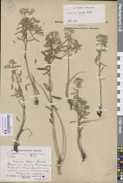
LE 01335920
Euphorbia discolor Ledeb. det. Prokhanov, Yaroslav Ivanovich
Additional identifications: Euphorbia maackii Meinsh. det. Drobow, Vasilii Petrovich Collectors: Drobow, Vasilii Petrovich Administrative regions: RU - Respublika Sakha (Yakutiya) - Amginskiy Rayon. Groups of specimens: Образцы сектора Сибири и Дальнего Востока РоссииRecord creation: 2026-07-14, Marina Yarichina, PhotoScan D2Citation: Specimen LE 01335920 // Virtual herbarium of Komarov Botanical Institute RAS — http://re.herbariumle.ru/01335920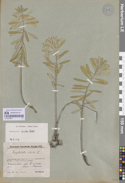
LE 01335919
Euphorbia discolor Ledeb. det. Prokhanov, Yaroslav Ivanovich
Additional identifications: Euphorbia esula L. Collectors: Yarovoi, Maxim Ivanovich Administrative regions: RU - Respublika Sakha (Yakutiya) - Tomponskiy District. Groups of specimens: Образцы сектора Сибири и Дальнего Востока РоссииCoordinates (geographic position): 63° 55′ 16.64″ N, 135° 51′ 4.95″ E ±500 mRecord creation: 2026-07-14, Marina Yarichina, PhotoScan D2Citation: Specimen LE 01335919 // Virtual herbarium of Komarov Botanical Institute RAS — http://re.herbariumle.ru/01335919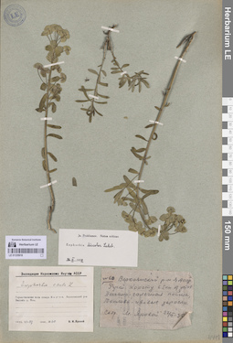
LE 01335918
Euphorbia discolor Ledeb. det. Prokhanov, Yaroslav Ivanovich
Additional identifications: Euphorbia esula L. Collectors: Yarovoi, Maxim Ivanovich Administrative regions: RU - Respublika Sakha (Yakutiya) - Verkhoyansky District. Groups of specimens: Образцы сектора Сибири и Дальнего Востока РоссииRecord creation: 2026-07-14, Marina Yarichina, PhotoScan D2Citation: Specimen LE 01335918 // Virtual herbarium of Komarov Botanical Institute RAS — http://re.herbariumle.ru/01335918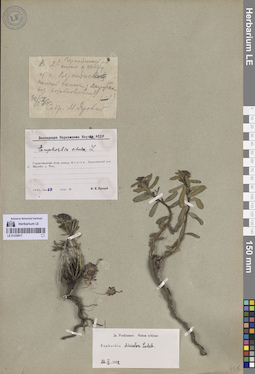
LE 01335917
Euphorbia discolor Ledeb. det. Prokhanov, Yaroslav Ivanovich
Additional identifications: Euphorbia esula L. Collectors: Yarovoi, Maxim Ivanovich Administrative regions: RU - Respublika Sakha (Yakutiya) - Verkhoyansky District. Groups of specimens: Образцы сектора Сибири и Дальнего Востока РоссииCoordinates (geographic position): 67° 34′ 32.6″ N, 133° 23′ 26.44″ E ±500 mRecord creation: 2026-07-14, Marina Yarichina, PhotoScan D2Citation: Specimen LE 01335917 // Virtual herbarium of Komarov Botanical Institute RAS — http://re.herbariumle.ru/01335917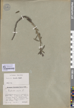
LE 01335916
Euphorbia discolor Ledeb. det. Prokhanov, Yaroslav Ivanovich
Additional identifications: Euphorbia esula L. Collectors: Yarovoi, Maxim Ivanovich Administrative regions: RU - Respublika Sakha (Yakutiya) - Verkhoyansky District. Groups of specimens: Образцы сектора Сибири и Дальнего Востока РоссииCoordinates (geographic position): 67° 33′ 52.97″ N, 133° 39′ 43.88″ E ±1000 mRecord creation: 2026-07-14, Marina Yarichina, PhotoScan D2Citation: Specimen LE 01335916 // Virtual herbarium of Komarov Botanical Institute RAS — http://re.herbariumle.ru/01335916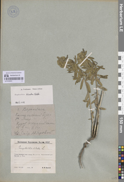
LE 01335915
Euphorbia discolor Ledeb. det. Prokhanov, Yaroslav Ivanovich
Additional identifications: Euphorbia esula L. Collectors: Yarovoi, Maxim Ivanovich Administrative regions: RU - Respublika Sakha (Yakutiya) - Verkhoyansky District. Groups of specimens: Образцы сектора Сибири и Дальнего Востока РоссииCoordinates (geographic position): 67° 32′ 55.2″ N, 133° 23′ 54.6″ E ±500 mRecord creation: 2026-07-14, Marina Yarichina, PhotoScan D2Citation: Specimen LE 01335915 // Virtual herbarium of Komarov Botanical Institute RAS — http://re.herbariumle.ru/01335915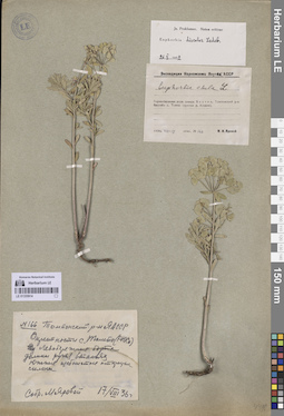
LE 01335914
Euphorbia discolor Ledeb. det. Prokhanov, Yaroslav Ivanovich
Additional identifications: Euphorbia esula L. Collectors: Yarovoi, Maxim Ivanovich Administrative regions: RU - Respublika Sakha (Yakutiya) - Tomponskiy District. Groups of specimens: Образцы сектора Сибири и Дальнего Востока РоссииCoordinates (geographic position): 63° 54′ 30.97″ N, 135° 52′ 59.42″ E ±1000 mRecord creation: 2026-07-14, Marina Yarichina, PhotoScan D2Citation: Specimen LE 01335914 // Virtual herbarium of Komarov Botanical Institute RAS — http://re.herbariumle.ru/01335914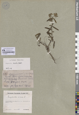
LE 01335913
Euphorbia discolor Ledeb. det. Prokhanov, Yaroslav Ivanovich
Additional identifications: Euphorbia esula L. Collectors: Yarovoi, Maxim Ivanovich Administrative regions: RU - Respublika Sakha (Yakutiya) - Verkhoyansky District. Groups of specimens: Образцы сектора Сибири и Дальнего Востока РоссииCoordinates (geographic position): 67° 27′ 2.18″ N, 132° 38′ 54.92″ E ±1000 mRecord creation: 2026-07-14, Marina Yarichina, PhotoScan D2Citation: Specimen LE 01335913 // Virtual herbarium of Komarov Botanical Institute RAS — http://re.herbariumle.ru/01335913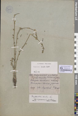
LE 01335912
Euphorbia discolor Ledeb. det. Prokhanov, Yaroslav Ivanovich
Additional identifications: Euphorbia esula L. det. Vassiljev, Viktor Nikolayevich Collectors: Yarovoi, Maxim Ivanovich Administrative regions: RU - Respublika Sakha (Yakutiya) - Verkhoyansky District. Groups of specimens: Образцы сектора Сибири и Дальнего Востока РоссииComment:Поражен грибами
Record creation: 2026-07-14, Marina Yarichina, PhotoScan D2Citation: Specimen LE 01335912 // Virtual herbarium of Komarov Botanical Institute RAS — http://re.herbariumle.ru/01335912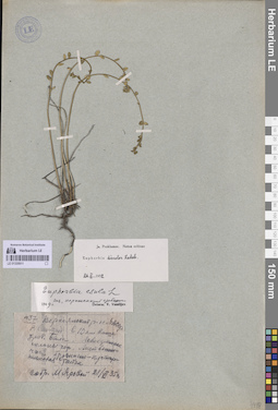
LE 01335911
Euphorbia discolor Ledeb. det. Prokhanov, Yaroslav Ivanovich
Additional identifications: Euphorbia esula L. det. Vassiljev, Viktor Nikolayevich Collectors: Yarovoi, Maxim Ivanovich Collection date: 21.06.1935. Administrative regions: RU - Respublika Sakha (Yakutiya) - Verkhoyansky District. Groups of specimens: Образцы сектора Сибири и Дальнего Востока РоссииOriginal label text:Верхоянский район ЯАССР, р. Сартанг в 10 км выше уроч. Бала. Левобережные склоны гор, лиственничная бруснично-кустарничковая тайга.
Coordinates (geographic position): 67° 7′ 21.76″ N, 132° 46′ 49.66″ E ±1000 mComment: Поражен грибами
Record creation: 2026-07-14, Marina Yarichina, PhotoScan D2Citation: Specimen LE 01335911 // Virtual herbarium of Komarov Botanical Institute RAS — http://re.herbariumle.ru/01335911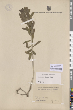
LE 01335910
Euphorbia discolor Ledeb. det. Prokhanov, Yaroslav Ivanovich
Collectors: Korjakina Administrative regions: RU - Respublika Sakha (Yakutiya) - Amginskiy Rayon. Groups of specimens: Образцы сектора Сибири и Дальнего Востока РоссииCoordinates (geographic position): 60° 54′ 8.4″ N, 131° 57′ 26.25″ ERecord creation: 2026-07-14, Marina Yarichina, PhotoScan D2Citation: Specimen LE 01335910 // Virtual herbarium of Komarov Botanical Institute RAS — http://re.herbariumle.ru/01335910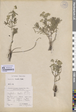
LE 01335909
Euphorbia discolor Ledeb. det. Prokhanov, Yaroslav Ivanovich
Additional identifications: Euphorbia esula L. det. Korzhevin, Wladimir Sergeevich Collectors: Korzhevin, Wladimir Sergeevich Administrative regions: RU - Respublika Sakha (Yakutiya). Groups of specimens: Образцы сектора Сибири и Дальнего Востока РоссииCoordinates (geographic position): 61° 59′ 29.73″ N, 129° 32′ 40.2″ E ±1000 mRecord creation: 2026-07-14, Marina Yarichina, PhotoScan D2Citation: Specimen LE 01335909 // Virtual herbarium of Komarov Botanical Institute RAS — http://re.herbariumle.ru/01335909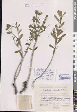
LE 01335908
Euphorbia discolor Ledeb.
Collectors: Andreev, Mikhail Petrovich; Razzhivin, Vladimir Yurievich; Sytin, Andrej Kirillovich Administrative regions: RU - Respublika Sakha (Yakutiya) - Oymyakonskiy District. Groups of specimens: Образцы сектора Сибири и Дальнего Востока РоссииCoordinates (geographic position): 64° 35′ 3.96″ N, 143° 17′ 37.46″ E ±1000 mRecord creation: 2026-07-14, Marina Yarichina, PhotoScan D2Citation: Specimen LE 01335908 // Virtual herbarium of Komarov Botanical Institute RAS — http://re.herbariumle.ru/01335908