View
Add
Copy
Edit
Delete
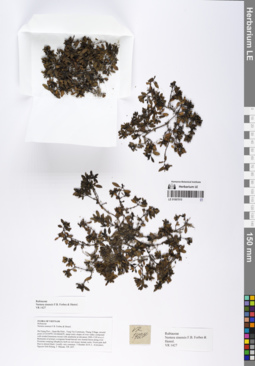
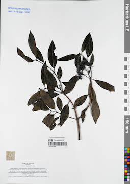
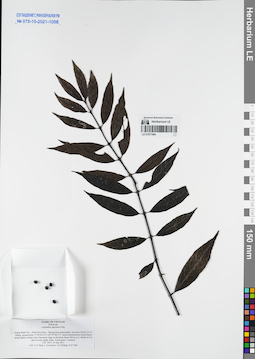
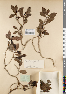
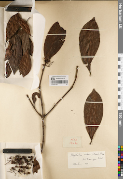
LE 01067015
Nertera sinensis F.B.Forbes & Hemsl. det. Averyanov, Leonid Vladimirovich at 07.10.2019
Collectors: Averyanov, Leonid Vladimirovich; Khang Sinh Nguyen; Maisak, Tatiana Viktorovna Field collecting number: VR1427. Collection date: 07.10.2019. Administrative regions: VN - Tinh Ha Giang. Groups of specimens: L. V. Averyanov specimens; L. V. Averyanov herbariumOriginal label text:FLORA OF VIETNAM
Rubiaceae
Nertera sinensis F.B. Forbes & Hemsl.
Ha Giang Prov., Quan Ba Distr., Tung Vai Commune, Thang Village, around point 23.05349ºN 104.86446ºE, steep rocky slopes of river valley composed with eroded limestone mixed with sandstone at elevation 1000–1100 m a.s.l. Remnants of primary evergreen broad-leaved very humid forest along river. Prostrate creeping lithophytic herb on wet mossy stream rocks. Fruits pale dull blue to almost black. Locally very common. 7 October 2019, L. Averyanov, Nguyen Sinh Khang, T. Maisak, VR 1427 (HN, LE01061116, LE01067015).
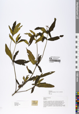
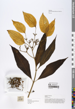
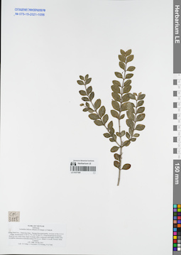
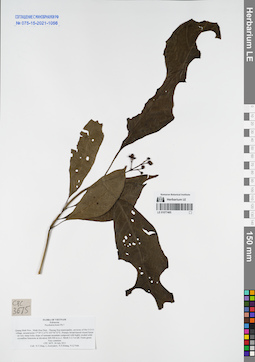
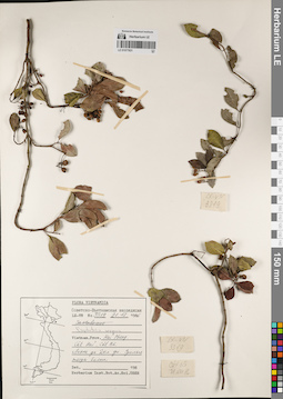
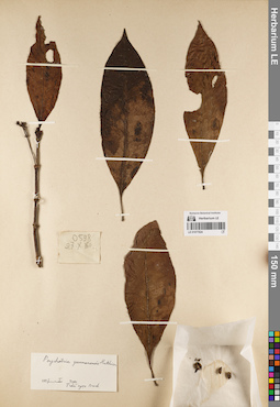
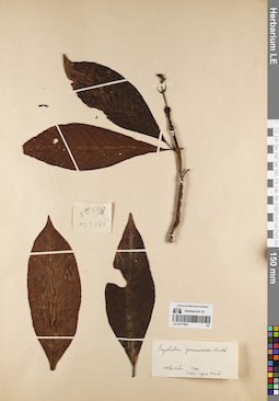
LE 01067021
Spiradiclis karstana L.Wu, X.Li & Q.R.Liu det. Averyanov, Leonid Vladimirovich at 11.10.2019
Collectors: Averyanov, Leonid Vladimirovich; Khang Sinh Nguyen; Maisak, Tatiana Viktorovna Field collecting number: VR1558. Collection date: 11.10.2019. Administrative regions: VN - Tinh Ha Giang. Groups of specimens: L. V. Averyanov specimens; L. V. Averyanov herbariumOriginal label text:FLORA OF VIETNAM
Rubiaceae
Spiradiclis karstana L. Wu, X. Li & Q.R. Liu
Ha Giang Prov., Quan Ba Distr., Can Ty Commune, Sin Suoi Ho Village, around point 23.09566ºN 105.02142ºE. Very steep mountain slopes composed of solid highly eroded karstic limestone at elevation 800–1000 m a.s.l. Remnants of primary evergreen broad-leaved and coniferous (with Calocedrus rupestris and Xanthocyparis vietnamensis) humid forest. Terrestrial herb or undershrub to 1 m tall in open rpcky place. Flowers purple. Occasional. 11 October 2019, L. Averyanov, Nguyen Sinh Khang, T. Maisak, VR 1558 (HN, LE01067021, LE01070220).
LE 01067043
Uncaria macrophylla Wall. det. Averyanov, Leonid Vladimirovich at 08.12.2020
Additional identifications: Uncaria sp. det. Averyanov, Leonid Vladimirovich at 18.04.2018 Collectors: Averyanov, Leonid Vladimirovich; Khang Sinh Nguyen; Maisak, Tatiana Viktorovna; Chuong Quang Ngan Field collecting number: VR377. Collection date: 18.04.2018. Administrative regions: VN - Tinh Ha Giang. Groups of specimens: L. V. Averyanov specimens; L. V. Averyanov herbarium; Flora of VietnamOriginal label text:FLORA OF VIETNAM
Coordinates (geographic position): 23° 7′ 46.4″ N, 104° 57′ 56.2″ E ±1000 mRecord creation: 2020-01-05, Leonid Averyanov, PhotoScan D1. Processing status: work_status_1Citation: Specimen LE 01067043 // Virtual herbarium of Komarov Botanical Institute RAS — http://re.herbariumle.ru/01067043Rubiaceae
Uncaria sp.
Ha Giang prov., Quan Ba distr., Bat Dai Son Nature Reserve, Thanh Van commune, Mo Sai village, around point 23º07ʹ46.4ʺN 104º57ʹ56.2ʺE, at elevation 1000-1190 m a.s.l., karstic, highly eroded mountains composed of solid marble-like limestone, primary evergreen broad-leaved and mixed (with Pseudotsuga sinensis) humid forest on steep rocky slopes near mountain tops. Woody vine or ascendent shrub to 3 m tall on rocky mountain slope. Flowers white to yellowish. Occasional. 18 April 2018, L. Averyanov, Nguyen Sinh Khang, Chuong Quang Ngan, T. Maisak, VR 377 (HN, LE01061495 – photo).
LE 01067048
Ixora henryi H.Lév. det. Averyanov, Leonid Vladimirovich at 08.12.2020
Additional identifications: Ixora sp. det. Averyanov, Leonid Vladimirovich at 18.04.2018 Collectors: Averyanov, Leonid Vladimirovich; Khang Sinh Nguyen; Maisak, Tatiana Viktorovna; Chuong Quang Ngan Field collecting number: VR378. Collection date: 18.04.2018. Administrative regions: VN - Tinh Ha Giang. Groups of specimens: L. V. Averyanov specimens; L. V. Averyanov herbarium; Flora of VietnamOriginal label text:FLORA OF VIETNAM
Coordinates (geographic position): 23° 7′ 46.4″ N, 104° 57′ 56.2″ E ±1000 mRecord creation: 2020-01-05, Leonid Averyanov, PhotoScan D1. Processing status: work_status_1Citation: Specimen LE 01067048 // Virtual herbarium of Komarov Botanical Institute RAS — http://re.herbariumle.ru/01067048Rubiaceae
Ixora sp.
Ha Giang prov., Quan Ba distr., Bat Dai Son Nature Reserve, Thanh Van commune, Mo Sai village, around point 23º07ʹ46.4ʺN 104º57ʹ56.2ʺE, at elevation 1000-1190 m a.s.l., karstic, highly eroded mountains composed of solid marble-like limestone, primary evergreen broad-leaved and mixed (with Pseudotsuga sinensis) humid forest on steep rocky slopes near mountain tops. Shrub 2-3 m tall on rocky mountain slope. Flowers white. Occasional. 18 April 2018, L. Averyanov, Nguyen Sinh Khang, Chuong Quang Ngan, T. Maisak, VR 378 (HN, LE01061496 – photo).
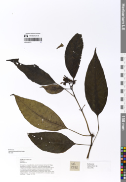
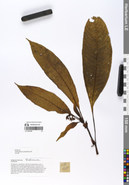
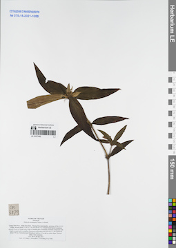
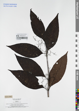
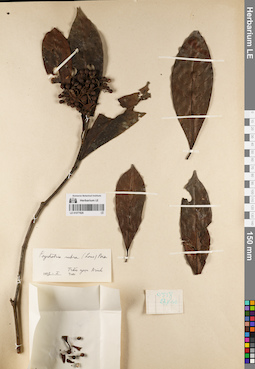
LE 01067075
Ophiorrhiza amplifolia Drake det. Averyanov, Leonid Vladimirovich at 11.10.2019
Collectors: Averyanov, Leonid Vladimirovich; Khang Sinh Nguyen; Maisak, Tatiana Viktorovna Field collecting number: VR1590. Collection date: 11.10.2019. Administrative regions: VN - Tinh Ha Giang. Groups of specimens: L. V. Averyanov specimens; L. V. Averyanov herbariumOriginal label text:FLORA OF VIETNAM
Rubiaceae
Ophiorrhiza amplifolia Drake
Ha Giang Prov., Quan Ba Distr., Can Ty Commune, Sin Suoi Ho Village, around point 23.09566ºN 105.02142ºE. Very steep mountain slopes composed of solid highly eroded karstic limestone at elevation 800–1000 m a.s.l. Remnants of primary evergreen broad-leaved and coniferous (with Calocedrus rupestris and Xanthocyparis vietnamensis) humid forest. Terrestrial herb to 1.5 m tall on shady very steep rocky slope. Flowers white with greenish apex. Very common. 11 October 2019, L. Averyanov, Nguyen Sinh Khang, T. Maisak, VR 1590 (HN, LE01067075, LE01070186).
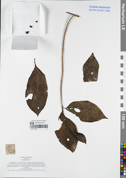
LE 01067084
Ophiorrhiza sp. det. Averyanov, Leonid Vladimirovich at 13.04.2018
Collectors: Averyanov, Leonid Vladimirovich; Khang Sinh Nguyen; Maisak, Tatiana Viktorovna; Chuong Quang Ngan Field collecting number: VR017. Collection date: 13.04.2018. Administrative regions: VN - Tinh Ha Giang. Groups of specimens: L. V. Averyanov specimens; L. V. Averyanov herbarium; Flora of VietnamOriginal label text:FLORA OF VIETNAM
Record creation: 2020-01-05, Leonid Averyanov, PhotoScan D1. Processing status: work_status_1Citation: Specimen LE 01067084 // Virtual herbarium of Komarov Botanical Institute RAS — http://re.herbariumle.ru/01067084Rubiaceae
Ophiorrhiza sp.?
Ha Giang prov., Quan Ba distr., Bat Dai Son commune, Bat Dai Son Nature Reserve, San Chu village, around point 23º08ʹ55.1ʺN 104º59ʹ45.7ʺE, 1100-1290 m a.s.l., karstic, highly eroded mountains composed of solid marble-like limestone, primary evergreen coniferous humid forest with Pseudotsuga sinensis on rocky mountain tops and ridges. Terrestrial erect herb to 1 m tall in rather shady place. Inflorescence rachis and flower buds pink. Occasional. 13 April 2018, L. Averyanov, Nguyen Sinh Khang, Chuong Quang Ngan, T. Maisak, VR 017 (HN).

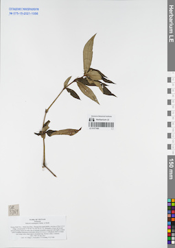
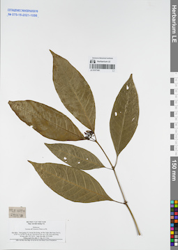
LE 01067085
Ophiorrhiza sp. det. Averyanov, Leonid Vladimirovich at 13.04.2018
Collectors: Averyanov, Leonid Vladimirovich; Khang Sinh Nguyen; Maisak, Tatiana Viktorovna Field collecting number: VR015. Collection date: 13.04.2018. Administrative regions: VN - Tinh Ha Giang. Groups of specimens: L. V. Averyanov specimens; L. V. Averyanov herbariumOriginal label text:FLORA OF VIETNAM
Rubiaceae
Ophiorrhiza sp. 1
Ha Giang prov., Quan Ba distr., Bat Dai Son commune, Bat Dai Son Nature Reserve, San Chu village, around point 23º08ʹ55.1ʺN 104º59ʹ45.7ʺE, 1100-1200 m a.s.l., karstic, highly eroded mountains composed of solid marble-like limestone, primary evergreen broad-leaved humid forest on very steep rocky slopes. Terrestrial erect herb to 0.5 m tall in shady places. Occasional. 13 April 2018, L. Averyanov, Nguyen Sinh Khang, Chuong Quang Ngan, T. Maisak, VR 015 (HN, LE01067085).
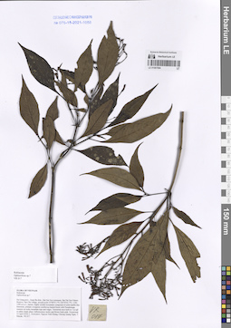
LE 01067105
Ophiorrhiza sp. det. Averyanov, Leonid Vladimirovich at 10.10.2019
Collectors: Averyanov, Leonid Vladimirovich; Khang Sinh Nguyen; Maisak, Tatiana Viktorovna Field collecting number: VR1512. Collection date: 10.10.2019. Administrative regions: VN - Tinh Ha Giang. Groups of specimens: L. V. Averyanov specimens; L. V. Averyanov herbariumOriginal label text:FLORA OF VIETNAM
Rubiaceae
Ophiorrhiza sp. 4
Ha Giang Prov., Quan Ba Distr., Thai An Commune, Seo Lung Two Village, around point 22.96988ºN 105.08646ºE. Very steep mountain slopes composed of stratified shale and clayey subsoil at elevation 800–1000 m a.s.l. Primary and secondary evergreen broad-leaved humid forest. Terrestrial herb to 1 m tall on steep shady rocky river slope. Flowers white. Common. 10 October 2019, L. Averyanov, Nguyen Sinh Khang, T. Maisak, VR 1512 (HN, LE01067105, LE01070179).
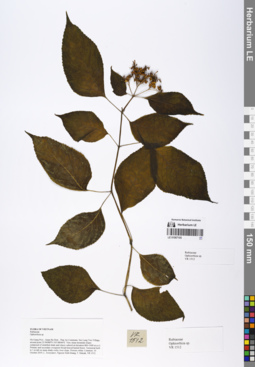
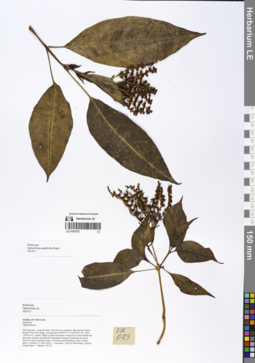
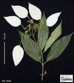
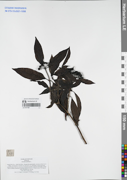
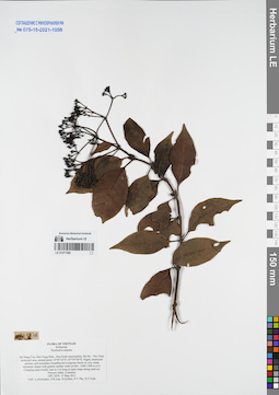
LE 01067132
Schizomussaenda dehiscens (Craib) H.L.Li det. Khang Sinh Nguyen at 10.10.2019
Collectors: Averyanov, Leonid Vladimirovich; Khang Sinh Nguyen; Maisak, Tatiana Viktorovna Field collecting number: VR1540. Collection date: 10.10.2019. Administrative regions: VN - Tinh Ha Giang. Groups of specimens: L. V. Averyanov specimens; L. V. Averyanov herbariumOriginal label text:FLORA OF VIETNAM
Rubiaceae
Schizomussaenda dehiscens (Craib) H.L. Li
Ha Giang Prov., Quan Ba Distr., Thai An Commune, Seo Lung Two Village, around point 22.96988ºN 105.08646ºE. Very steep mountain slopes composed of stratified shale and clayey subsoil at elevation 800–1000 m a.s.l. Primary and secondary evergreen broad-leaved humid forest. Treelet 6-8 m tall on open steep river slope. Inflorescence bract pure white. Common. 10 October 2019, L. Averyanov, Nguyen Sinh Khang, T. Maisak, VR 1540 (HN, LE01067132, LE01070157).
LE 01067261
Mycetia sp. det. Averyanov, Leonid Vladimirovich at 08.12.2020
Additional identifications: Ophiorrhiza sp. det. Averyanov, Leonid Vladimirovich at 18.04.2019 Collectors: Averyanov, Leonid Vladimirovich; Khang Sinh Nguyen; Maisak, Tatiana Viktorovna; Chuong Quang Ngan Field collecting number: VR382. Collection date: 18.04.2018. Administrative regions: VN - Tinh Ha Giang. Groups of specimens: L. V. Averyanov specimens; L. V. Averyanov herbarium; Flora of VietnamOriginal label text:FLORA OF VIETNAM
Coordinates (geographic position): 23° 7′ 46.4″ N, 104° 57′ 56.2″ E ±1000 mRecord creation: 2020-01-05, Leonid Averyanov, PhotoScan D1. Processing status: work_status_1Citation: Specimen LE 01067261 // Virtual herbarium of Komarov Botanical Institute RAS — http://re.herbariumle.ru/01067261Rubiaceae
Ophiorrhiza sp. s.l.
Ha Giang prov., Quan Ba distr., Bat Dai Son Nature Reserve, Thanh Van commune, Mo Sai village, around point 23º07ʹ46.4ʺN 104º57ʹ56.2ʺE, at elevation 1000-1190 m a.s.l., karstic, highly eroded mountains composed of solid marble-like limestone, primary evergreen broad-leaved and mixed (with Pseudotsuga sinensis) humid forest on steep rocky slopes near mountain tops. Terrestrial herb to 0.5 m tall on shady rocky mountain slope. Flowers whitish. Common. 18 April 2018, L. Averyanov, Nguyen Sinh Khang, Chuong Quang Ngan, T. Maisak, VR 382 (HN, LE01061500 – photo).
LE 01067557
Ophiorrhiza amplifolia Drake det. Averyanov, Leonid Vladimirovich at 13.04.2018
Collectors: Averyanov, Leonid Vladimirovich; et al. Field collecting number: VR073. Collection date: 13.04.2018. Administrative regions: VN - Tinh Ha Giang. Groups of specimens: L. V. Averyanov specimens; L. V. Averyanov herbariumOriginal label text:FLORA OF VIETNAM
Rubiaceae
Ophiorrhiza amplifolia Drake
Ha Giang prov., Quan Ba distr., Bat Dai Son commune, Bat Dai Son Nature Reserve, San Chu village, around point 23º08ʹ55.1ʺN 104º59ʹ45.7ʺE, 1000-1200 m a.s.l., karstic, highly eroded mountains composed of solid marble-like limestone, primary and partially degraded evergreen broad-leaved humid forest on rocky mountain slopes. Terrestrial and lithophytic herb in shady place. Common. 13 April 2018, L. Averyanov, Nguyen Sinh Khang, Chuong Quang Ngan, T. Maisak, VR 073 (HN, LE01058104, LE01067557).
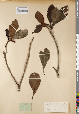
LE 01067558
Xanthophytum polyanthum Pit. det. Averyanov, Leonid Vladimirovich at 15.04.2018
Collectors: Averyanov, Leonid Vladimirovich; et al. Field collecting number: VR168. Collection date: 15.04.2018. Administrative regions: VN - Tinh Ha Giang. Groups of specimens: L. V. Averyanov specimens; L. V. Averyanov herbariumOriginal label text:FLORA OF VIETNAM
Rubiaceae
Xanthophytum polyanthum Pit.
Ha Giang prov., Quan Ba distr., Bat Dai Son Nature Reserve, Can Ty commune, Lung Vay village, around point 23º05ʹ46.7ʺN 105º02ʹ53.1ʺE, 1100-1280 m a.s.l., karstic, highly eroded mountains composed of solid marble-like limestone, primary evergreen broad-leaved humid forest on steep rocky slopes near mountain tops. Erect terrestrial and lithophytic herb to 1.5 m tall among shady rocks. Young flower buds light green. Occasional. 15 April 2018, L. Averyanov, Nguyen Sinh Khang, Chuong Quang Ngan, T. Maisak, VR 168 (HN, LE01058128, LE01067558).
LE 01070157
Schizomussaenda dehiscens (Craib) H.L.Li det. Khang Sinh Nguyen, Averyanov, Leonid Vladimirovich at 10.12.2019
Collectors: Averyanov, Leonid Vladimirovich; Khang Sinh Nguyen; Maisak, Tatiana Viktorovna Field collecting number: VR1540. Collection date: 10.10.2019. Administrative regions: VN - Tinh Ha Giang. Groups of specimens: L. V. Averyanov specimens; L. V. Averyanov photosOriginal label text:FLORA OF VIETNAM
Coordinates (geographic position): 22° 58′ 11.57″ N, 105° 5′ 11.26″ E ±1000 mComment: Rubiaceae
Schizomussaenda dehiscens (Craib) H.L. Li
Ha Giang Prov., Quan Ba Distr., Thai An Commune, Seo Lung Two Village, around point 22.96988ºN 105.08646ºE. Very steep mountain slopes composed of stratified shale and clayey subsoil at elevation 800–1000 m a.s.l. Primary and secondary evergreen broad-leaved humid forest. Treelet 6-8 m tall on open steep river slope. Inflorescence bract pure white. Common. 10 October 2019, L. Averyanov, Nguyen Sinh Khang, T. Maisak, VR 1540.
All photos © L. Averyanov & K.S. Nguyen
Record creation: 2020-01-04, Аверьянов Леонид ВладимировичCitation: Specimen LE 01070157 // Virtual herbarium of Komarov Botanical Institute RAS — http://re.herbariumle.ru/01070157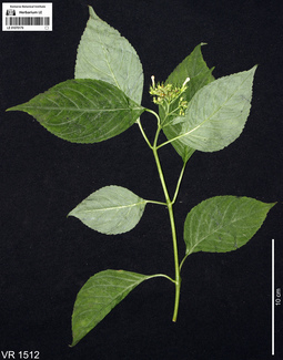
LE 01070179
Ophiorrhiza sp. det. Averyanov, Leonid Vladimirovich at 10.12.2019
Collectors: Averyanov, Leonid Vladimirovich; Khang Sinh Nguyen; Maisak, Tatiana Viktorovna Field collecting number: VR1512. Collection date: 10.10.2019. Administrative regions: VN - Tinh Ha Giang. Groups of specimens: L. V. Averyanov specimens; L. V. Averyanov photosOriginal label text:FLORA OF VIETNAM
Coordinates (geographic position): 22° 58′ 11.57″ N, 105° 5′ 11.26″ E ±1000 mComment: Rubiaceae
Ophiorrhiza sp.
Ha Giang Prov., Quan Ba Distr., Thai An Commune, Seo Lung Two Village, around point 22.96988ºN 105.08646ºE. Very steep mountain slopes composed of stratified shale and clayey subsoil at elevation 800–1000 m a.s.l. Primary and secondary evergreen broad-leaved humid forest. Terrestrial herb to 1 m tall on steep shady rocky river slope. Flowers white. Common. 10 October 2019, L. Averyanov, Nguyen Sinh Khang, T. Maisak, VR 1512.
All photos © L. Averyanov & K.S. Nguyen
Record creation: 2020-01-04, Аверьянов Леонид ВладимировичCitation: Specimen LE 01070179 // Virtual herbarium of Komarov Botanical Institute RAS — http://re.herbariumle.ru/01070179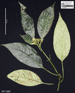
LE 01070186
Ophiorrhiza amplifolia Drake det. Averyanov, Leonid Vladimirovich at 08.12.2020
Additional identifications: Ophiorrhiza sp. det. Averyanov, Leonid Vladimirovich at 10.12.2019 Collectors: Averyanov, Leonid Vladimirovich; Khang Sinh Nguyen; Maisak, Tatiana Viktorovna Field collecting number: VR1590. Collection date: 11.10.2019. Administrative regions: VN - Tinh Ha Giang. Groups of specimens: L. V. Averyanov specimens; L. V. Averyanov photosOriginal label text:FLORA OF VIETNAM
Coordinates (geographic position): 23° 5′ 44.38″ N, 105° 1′ 17.11″ E ±1000 mComment: Rubiaceae
Ophiorrhiza sp.
Ha Giang Prov., Quan Ba Distr., Can Ty Commune, Sin Suoi Ho Village, around point 23.09566ºN 105.02142ºE. Very steep mountain slopes composed of solid highly eroded karstic limestone at elevation 800–1000 m a.s.l. Remnants of primary evergreen broad-leaved and coniferous (with Calocedrus rupestris and Xanthocyparis vietnamensis) humid forest. Terrestrial herb to 1.5 m tall on shady very steep rocky slope. Flowers white with greenish apex. Very common. 11 October 2019, L. Averyanov, Nguyen Sinh Khang, T. Maisak, VR 1590.
All photos © L. Averyanov & K.S. Nguyen
Record creation: 2020-01-04, Аверьянов Леонид ВладимировичCitation: Specimen LE 01070186 // Virtual herbarium of Komarov Botanical Institute RAS — http://re.herbariumle.ru/01070186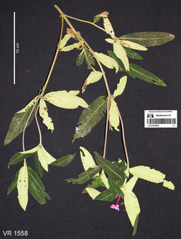
LE 01070220
Spiradiclis karstana L.Wu, X.Li & Q.R.Liu det. Averyanov, Leonid Vladimirovich at 08.12.2020
Additional identifications: Spiradiclis sp. det. Averyanov, Leonid Vladimirovich, Khang Sinh Nguyen at 11.10.2019 Collectors: Averyanov, Leonid Vladimirovich; Khang Sinh Nguyen; Maisak, Tatiana Viktorovna Field collecting number: VR1558. Collection date: 11.10.2019. Administrative regions: VN - Tinh Ha Giang. Groups of specimens: L. V. Averyanov specimens; L. V. Averyanov photosOriginal label text:FLORA OF VIETNAM
Coordinates (geographic position): 23° 5′ 44.38″ N, 105° 1′ 17.11″ E ±1000 mComment: Rubiaceae
Spiradiclis sp.
Ha Giang Prov., Quan Ba Distr., Can Ty Commune, Sin Suoi Ho Village, around point 23.09566ºN 105.02142ºE. Very steep mountain slopes composed of solid highly eroded karstic limestone at elevation 800–1000 m a.s.l. Remnants of primary evergreen broad-leaved and coniferous (with Calocedrus rupestris and Xanthocyparis vietnamensis) humid forest. Terrestrial herb or undershrub to 1 m tall in open rpcky place. Flowers purple. Occasional. 11 October 2019, L. Averyanov, Nguyen Sinh Khang, T. Maisak, VR 1558.
All photos © L. Averyanov & K.S. Nguyen
Record creation: 2020-01-04, Аверьянов Леонид ВладимировичCitation: Specimen LE 01070220 // Virtual herbarium of Komarov Botanical Institute RAS — http://re.herbariumle.ru/01070220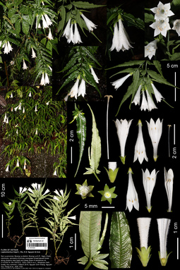
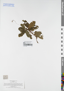
LE 01073034
Leptomischus hiepii L.Wu, K.S.Nguyen & Aver. det. Khang Sinh Nguyen at 02.03.2019
Collectors: Khang Sinh Nguyen; et al. Field collecting number: NSK 1153. Collection date: 02.03.2019. Administrative regions: VN - Tinh Son La. Groups of specimens: L. V. Averyanov specimens; L. V. Averyanov photosOriginal label text:FLORA OF VIETNAM Rubiaceae Leptomischus hiepii L. Wu, K.S. Nguyen & Aver. sp nov. Son La province, Muong La district, Muong La N.R., Ngoc Chien commune. Primary evergreen broad-leaved forest along streams at the base and slope of sandstone mountain, around point 21.61032° N 104.10576° E, at elevation of 1350 m a.s.l. Lithophytic perennial herbs around 30-45 cm tall, stem sub-erect, flower pure white, calyx and corolla glabrous adaxially, white pubescence abaxially, very common at waterfalls and humid places in a restricted area (around 2500 m2). March 2, 2019, Nguyen Sinh Khang, Nguyen Duc Thang et al., NSK 1153 (holotype CSFI; isotype CSFI, HN, LE 01058686, LE 01058688, LE 01073034 - photo), including living plants and DNA samples (HN)
Coordinates (geographic position): 21° 36′ 37.15″ N, 104° 6′ 20.74″ E ±1000 mComment: All photos © by Nguyen SInh Khang
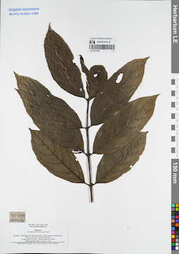
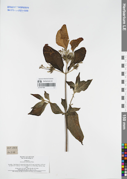
LE 01077480
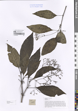
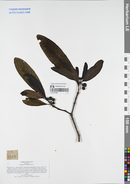
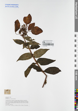
Gaertnera vaginans Merr. det. Averyanov, Leonid Vladimirovich at 05.08.2011
Collectors: Tien Hiep Nguyen; Averyanov, Leonid Vladimirovich; et al. Field collecting number: CPC3983. Collection date: 05.08.2011. Administrative regions: VN - Tinh Quang Binh. Groups of specimens: L. V. Averyanov specimens; L. V. Averyanov herbarium; Соглашение Минобрнауки №075-15-2021-1056Original label text:FLORA OF VIETNAM
Rubiaceae
Gaertnera vaginans (DC.) Merr.
Quang Binh Prov., Minh Hoa Distr., Thuong Hoa municipality, around point 17°41′28”N 105°53′42.7”E.
Primary closed evergreen broad-leaved forest on middle part of slope of remnant mountain composed with solid crystalline limestone at elevation about 650 m a.s.l.
Shrub about 4 m tall on mountain top. Fruits dark green. Common on mountain top.
CPC 3983 5 August 2011
Coll.: N.T.Hiep, L.Averyanov, N.S.Khang, N.Q.Vinh, N.V.Tap, P.V.The, L.T.Kien.
Coordinates (geographic position): 17° 41′ 28″ N, 105° 53′ 42.7″ E ±1000 mRecord creation: 2021-11-24, Tatiana Maisak, PhotoScan D2. Processing status: work_status_1Citation: Specimen LE 01077480 // Virtual herbarium of Komarov Botanical Institute RAS — http://re.herbariumle.ru/01077480Rubiaceae
Gaertnera vaginans (DC.) Merr.
Quang Binh Prov., Minh Hoa Distr., Thuong Hoa municipality, around point 17°41′28”N 105°53′42.7”E.
Primary closed evergreen broad-leaved forest on middle part of slope of remnant mountain composed with solid crystalline limestone at elevation about 650 m a.s.l.
Shrub about 4 m tall on mountain top. Fruits dark green. Common on mountain top.
CPC 3983 5 August 2011
Coll.: N.T.Hiep, L.Averyanov, N.S.Khang, N.Q.Vinh, N.V.Tap, P.V.The, L.T.Kien.
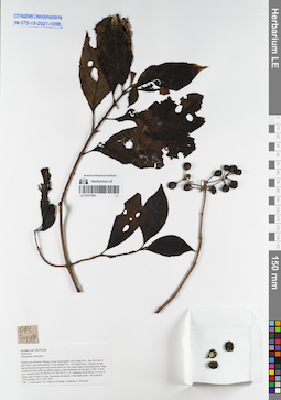
LE 01077481
Lasianthus biflorus (Blume) M.Gangop. & Chakrab. det. Averyanov, Leonid Vladimirovich at 28.07.2011
Collectors: Tien Hiep Nguyen; Averyanov, Leonid Vladimirovich; et al. Field collecting number: CPC3888. Collection date: 28.07.2011. Administrative regions: VN - Tinh Quang Binh. Groups of specimens: L. V. Averyanov specimens; L. V. Averyanov herbarium; Соглашение Минобрнауки №075-15-2021-1056Original label text:FLORA OF VIETNAM
Rubiaceae
Lasianthus biflorus (Blume) M.Gangop. et Chakrab.
Quang Binh Prov., Minh Hoa Distr., Thuong Hoa municipality, environs of Mo O O O village, around point 17°39′31.7”N 105°54′48.2”E.
Closed broad-leaved primary forest on very steep rocky slope of stream valley composed with highly eroded solid crystalline limestone at elevation about 422 m a.s.l.
Shrub 1-2 m tall. Flowers white. Common.
CPC 3888 28 July 2011
Coll.: N.T.Hiep, L.Averyanov, N.S.Khang, N.Q.Vinh.
Coordinates (geographic position): 17° 39′ 31.7″ N, 105° 54′ 48.2″ E ±1000 mRecord creation: 2021-11-24, Tatiana Maisak, PhotoScan D2. Processing status: work_status_1Citation: Specimen LE 01077481 // Virtual herbarium of Komarov Botanical Institute RAS — http://re.herbariumle.ru/01077481Rubiaceae
Lasianthus biflorus (Blume) M.Gangop. et Chakrab.
Quang Binh Prov., Minh Hoa Distr., Thuong Hoa municipality, environs of Mo O O O village, around point 17°39′31.7”N 105°54′48.2”E.
Closed broad-leaved primary forest on very steep rocky slope of stream valley composed with highly eroded solid crystalline limestone at elevation about 422 m a.s.l.
Shrub 1-2 m tall. Flowers white. Common.
CPC 3888 28 July 2011
Coll.: N.T.Hiep, L.Averyanov, N.S.Khang, N.Q.Vinh.
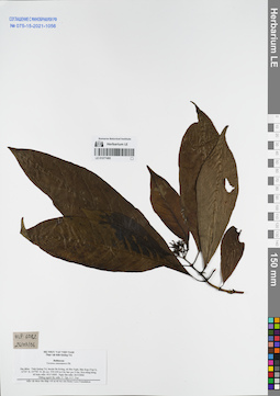
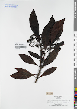
LE 01077482
Hedyotis acutangula Benth. det. Averyanov, Leonid Vladimirovich at 28.07.2011
Collectors: Tien Hiep Nguyen; Averyanov, Leonid Vladimirovich; et al. Field collecting number: CPC3879. Collection date: 28.07.2011. Administrative regions: VN - Tinh Quang Binh. Groups of specimens: L. V. Averyanov specimens; L. V. Averyanov herbarium; Соглашение Минобрнауки №075-15-2021-1056Original label text:FLORA OF VIETNAM
Rubiaceae
Hedyotis acutangula Champ. ex Benth.
Quang Binh Prov., Minh Hoa Distr., Thuong Hoa municipality, environs of Mo O O O village, around point 17°39′21.1”N 105°54′41.7”E.
Closed broad-leaved evergreen primary forest on steep rocky slope of middle part of remnant mountain composed with highly eroded solid crystalline limestone at elevation 400-450 m a.s.l. (mt summit at about 570 m).
Terrestrial and lithophytic herb to 0.5 m tall on rocky slope. Flowers white. Very common.
CPC 3879 28 July 2011
Coll.: N.T.Hiep, L.Averyanov, N.S.Khang, N.Q.Vinh.
Coordinates (geographic position): 17° 39′ 21.1″ N, 105° 54′ 41.7″ E ±1000 mRecord creation: 2021-11-24, Tatiana Maisak, PhotoScan D2. Processing status: work_status_1Citation: Specimen LE 01077482 // Virtual herbarium of Komarov Botanical Institute RAS — http://re.herbariumle.ru/01077482Rubiaceae
Hedyotis acutangula Champ. ex Benth.
Quang Binh Prov., Minh Hoa Distr., Thuong Hoa municipality, environs of Mo O O O village, around point 17°39′21.1”N 105°54′41.7”E.
Closed broad-leaved evergreen primary forest on steep rocky slope of middle part of remnant mountain composed with highly eroded solid crystalline limestone at elevation 400-450 m a.s.l. (mt summit at about 570 m).
Terrestrial and lithophytic herb to 0.5 m tall on rocky slope. Flowers white. Very common.
CPC 3879 28 July 2011
Coll.: N.T.Hiep, L.Averyanov, N.S.Khang, N.Q.Vinh.
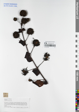
LE 01077483
Mussaenda bonii Pit. ⟮prelim. ID⟯ det. Averyanov, Leonid Vladimirovich at 04.08.2011
Collectors: Tien Hiep Nguyen; Averyanov, Leonid Vladimirovich; et al. Field collecting number: CPC3933. Collection date: 04.08.2011. Administrative regions: VN - Tinh Quang Binh. Groups of specimens: L. V. Averyanov specimens; L. V. Averyanov herbarium; Соглашение Минобрнауки №075-15-2021-1056Original label text:FLORA OF VIETNAM
Rubiaceae
Mussaenda bonii Pit.?
Quang Binh Prov., Minh Hoa Distr., Thuong Hoa municipality, around point 17°41′28”N 105°53′42.7”E.
Wet primary evergreen broad-leaved forest on shady humid rocky slope of narrow stream canyon composed with solid crystalline limestone at elevation about 600 m a.s.l.
Woody vine about 4 m long in open place. Fruits green. Occasional.
CPC 3933 4 August 2011
Coll.: N.T.Hiep, L.Averyanov, N.S.Khang, N.Q.Vinh, N.V.Tap, P.V.The, L.T.Kien.
Coordinates (geographic position): 17° 41′ 28″ N, 105° 53′ 42.7″ E ±1000 mRecord creation: 2021-11-24, Tatiana Maisak, PhotoScan D2. Processing status: work_status_1Citation: Specimen LE 01077483 // Virtual herbarium of Komarov Botanical Institute RAS — http://re.herbariumle.ru/01077483Rubiaceae
Mussaenda bonii Pit.?
Quang Binh Prov., Minh Hoa Distr., Thuong Hoa municipality, around point 17°41′28”N 105°53′42.7”E.
Wet primary evergreen broad-leaved forest on shady humid rocky slope of narrow stream canyon composed with solid crystalline limestone at elevation about 600 m a.s.l.
Woody vine about 4 m long in open place. Fruits green. Occasional.
CPC 3933 4 August 2011
Coll.: N.T.Hiep, L.Averyanov, N.S.Khang, N.Q.Vinh, N.V.Tap, P.V.The, L.T.Kien.
LE 01077484
Lasianthus japonicus Miq. det. Averyanov, Leonid Vladimirovich at 29.07.2011
Collectors: Tien Hiep Nguyen; Averyanov, Leonid Vladimirovich; et al. Field collecting number: CPC3912. Collection date: 29.07.2011. Administrative regions: VN - Tinh Quang Binh. Groups of specimens: L. V. Averyanov specimens; L. V. Averyanov herbarium; Соглашение Минобрнауки №075-15-2021-1056Original label text:FLORA OF VIETNAM
Rubiaceae
Lasianthus japonicus Miq.
Quang Binh Prov., Minh Hoa Distr., Thuong Hoa municipality, environs of Mo O O O village, around point 17°40′03.6”N 105°55′08.5”E.
Dense broad-leaved closed forest along highly eroded rocky limestone ridge at elevation about 500 m a.s.l.
Shrub to 2 m tall on rocky shady slope. Fruits green. Common.
CPC 3912 29 July 2011
Coll.: N.T.Hiep, L.Averyanov, N.S.Khang, N.Q.Vinh.
Coordinates (geographic position): 17° 40′ 3.6″ N, 105° 55′ 8.5″ E ±1000 mRecord creation: 2021-11-24, Tatiana Maisak, PhotoScan D2. Processing status: work_status_1Citation: Specimen LE 01077484 // Virtual herbarium of Komarov Botanical Institute RAS — http://re.herbariumle.ru/01077484Rubiaceae
Lasianthus japonicus Miq.
Quang Binh Prov., Minh Hoa Distr., Thuong Hoa municipality, environs of Mo O O O village, around point 17°40′03.6”N 105°55′08.5”E.
Dense broad-leaved closed forest along highly eroded rocky limestone ridge at elevation about 500 m a.s.l.
Shrub to 2 m tall on rocky shady slope. Fruits green. Common.
CPC 3912 29 July 2011
Coll.: N.T.Hiep, L.Averyanov, N.S.Khang, N.Q.Vinh.
LE 01077485
Psychotria bonii Pit. det. Averyanov, Leonid Vladimirovich at 24.07.2011
Collectors: Tien Hiep Nguyen; Averyanov, Leonid Vladimirovich; et al. Field collecting number: CPC3675. Collection date: 24.07.2011. Administrative regions: VN - Tinh Quang Binh. Groups of specimens: L. V. Averyanov specimens; L. V. Averyanov herbarium; Соглашение Минобрнауки №075-15-2021-1056Original label text:FLORA OF VIETNAM
Rubiaceae
Psychotria bonii Pit.?
Quang Binh Prov., Minh Hoa Distr., Thuong Hoa municipality, environs of Mo O O O village, around point 17°39′11.6”N 105°54′53”E.
Primary broad-leaved closed forest on very steep rocky slope of remnant mountain composed with highly eroded solid crystalline limestone at elevation 400-500 m a.s.l.
Shrub 2-2.5 m tall. Fruits green. Very common.
CPC 3675 24 July 2011
Coll.: N.T.Hiep, L.Averyanov, N.S.Khang, N.Q.Vinh.
Coordinates (geographic position): 17° 39′ 11.6″ N, 105° 54′ 53″ E ±1000 mRecord creation: 2021-11-24, Tatiana Maisak, PhotoScan D2. Processing status: work_status_1Citation: Specimen LE 01077485 // Virtual herbarium of Komarov Botanical Institute RAS — http://re.herbariumle.ru/01077485Rubiaceae
Psychotria bonii Pit.?
Quang Binh Prov., Minh Hoa Distr., Thuong Hoa municipality, environs of Mo O O O village, around point 17°39′11.6”N 105°54′53”E.
Primary broad-leaved closed forest on very steep rocky slope of remnant mountain composed with highly eroded solid crystalline limestone at elevation 400-500 m a.s.l.
Shrub 2-2.5 m tall. Fruits green. Very common.
CPC 3675 24 July 2011
Coll.: N.T.Hiep, L.Averyanov, N.S.Khang, N.Q.Vinh.
LE 01077486
Hedyotis acutangula Benth. det. Averyanov, Leonid Vladimirovich at 26.07.2011
Collectors: Tien Hiep Nguyen; Averyanov, Leonid Vladimirovich; et al. Field collecting number: CPC3769. Collection date: 26.07.2011. Administrative regions: VN - Tinh Quang Binh. Groups of specimens: L. V. Averyanov specimens; L. V. Averyanov herbarium; Соглашение Минобрнауки №075-15-2021-1056Original label text:FLORA OF VIETNAM
Rubiaceae
Hedyotis acutangula Champ. ex Benth.
Quang Binh Prov., Minh Hoa Distr., Thuong Hoa municipality, environs of Mo O O O village, around point 17°39′36.7”N 105°54′55.7”E.
Remnants of short tall broad-leaved primary forest on rocky top of remnant mountain composed with highly eroded solid crystalline limestone at elevation about 612 m a.s.l.
Lithophytic herb on shady very steep rocky slope near to mountain top. Flowers white. Common.
CPC 3769 26 July 2011
Coll.: N.T.Hiep, L.Averyanov, N.S.Khang, N.Q.Vinh.
Coordinates (geographic position): 17° 39′ 36.7″ N, 105° 54′ 55.7″ E ±1000 mRecord creation: 2021-11-24, Tatiana Maisak, PhotoScan D2. Processing status: work_status_1Citation: Specimen LE 01077486 // Virtual herbarium of Komarov Botanical Institute RAS — http://re.herbariumle.ru/01077486Rubiaceae
Hedyotis acutangula Champ. ex Benth.
Quang Binh Prov., Minh Hoa Distr., Thuong Hoa municipality, environs of Mo O O O village, around point 17°39′36.7”N 105°54′55.7”E.
Remnants of short tall broad-leaved primary forest on rocky top of remnant mountain composed with highly eroded solid crystalline limestone at elevation about 612 m a.s.l.
Lithophytic herb on shady very steep rocky slope near to mountain top. Flowers white. Common.
CPC 3769 26 July 2011
Coll.: N.T.Hiep, L.Averyanov, N.S.Khang, N.Q.Vinh.
LE 01077487
Morinda umbellata L. det. Averyanov, Leonid Vladimirovich at 26.07.2011
Collectors: Tien Hiep Nguyen; Averyanov, Leonid Vladimirovich; et al. Field collecting number: CPC3781. Collection date: 26.07.2011. Administrative regions: VN - Tinh Quang Binh. Groups of specimens: L. V. Averyanov specimens; L. V. Averyanov herbarium; Соглашение Минобрнауки №075-15-2021-1056Original label text:FLORA OF VIETNAM
Rubiaceae
Morinda umbellata L.
Quang Binh Prov., Minh Hoa Distr., Thuong Hoa municipality, environs of Mo O O O village, around point 17°39′36.7”N 105°54′55.7”E.
Remnants of short tall broad-leaved primary forest on rocky top of remnant mountain composed with highly eroded solid crystalline limestone at elevation about 612 m a.s.l.
Woody vine to 5 m long on rocky mountain top. Not rare.
CPC 3781 26 July 2011
Coll.: N.T.Hiep, L.Averyanov, N.S.Khang, N.Q.Vinh.
Coordinates (geographic position): 17° 39′ 36.7″ N, 105° 54′ 55.7″ E ±1000 mRecord creation: 2021-11-24, Tatiana Maisak, PhotoScan D2. Processing status: work_status_1Citation: Specimen LE 01077487 // Virtual herbarium of Komarov Botanical Institute RAS — http://re.herbariumle.ru/01077487Rubiaceae
Morinda umbellata L.
Quang Binh Prov., Minh Hoa Distr., Thuong Hoa municipality, environs of Mo O O O village, around point 17°39′36.7”N 105°54′55.7”E.
Remnants of short tall broad-leaved primary forest on rocky top of remnant mountain composed with highly eroded solid crystalline limestone at elevation about 612 m a.s.l.
Woody vine to 5 m long on rocky mountain top. Not rare.
CPC 3781 26 July 2011
Coll.: N.T.Hiep, L.Averyanov, N.S.Khang, N.Q.Vinh.
LE 01077488
Brachytome wallichii Hook.f. det. Averyanov, Leonid Vladimirovich at 26.07.2011
Collectors: Tien Hiep Nguyen; Averyanov, Leonid Vladimirovich; et al. Field collecting number: CPC3784. Collection date: 26.07.2011. Administrative regions: VN - Tinh Quang Binh. Groups of specimens: L. V. Averyanov specimens; L. V. Averyanov herbarium; Соглашение Минобрнауки №075-15-2021-1056Original label text:FLORA OF VIETNAM
Rubiaceae
Brachytome wallichii Hook.f.?
Quang Binh Prov., Minh Hoa Distr., Thuong Hoa municipality, environs of Mo O O O village, around point 17°39′36.7”N 105°54′55.7”E.
Remnants of short tall broad-leaved primary forest on rocky top of remnant mountain composed with highly eroded solid crystalline limestone at elevation about 612 m a.s.l.
Shrub about 2 m tall on rocky mountain top. Fruits dark green. Very common. Co-dominant of short mountain top forest.
CPC 3784 26 July 2011
Coll.: N.T.Hiep, L.Averyanov, N.S.Khang, N.Q.Vinh.
Coordinates (geographic position): 17° 39′ 36.7″ N, 105° 54′ 55.7″ E ±1000 mRecord creation: 2021-11-24, Tatiana Maisak, PhotoScan D2. Processing status: work_status_1Citation: Specimen LE 01077488 // Virtual herbarium of Komarov Botanical Institute RAS — http://re.herbariumle.ru/01077488Rubiaceae
Brachytome wallichii Hook.f.?
Quang Binh Prov., Minh Hoa Distr., Thuong Hoa municipality, environs of Mo O O O village, around point 17°39′36.7”N 105°54′55.7”E.
Remnants of short tall broad-leaved primary forest on rocky top of remnant mountain composed with highly eroded solid crystalline limestone at elevation about 612 m a.s.l.
Shrub about 2 m tall on rocky mountain top. Fruits dark green. Very common. Co-dominant of short mountain top forest.
CPC 3784 26 July 2011
Coll.: N.T.Hiep, L.Averyanov, N.S.Khang, N.Q.Vinh.
LE 01077489
Psychotria serpens L. det. Averyanov, Leonid Vladimirovich at 15.05.2011
Collectors: Averyanov, Leonid Vladimirovich; et al. Field collecting number: CPC3278. Collection date: 15.05.2011. Administrative regions: VN - Thanh Pho GJa Nang. Groups of specimens: L. V. Averyanov specimens; L. V. Averyanov herbarium; Соглашение Минобрнауки №075-15-2021-1056Original label text:FLORA OF VIETNAM
Rubiaceae
Psychotria serpens
Da Nang City, Hoa Vang Distr., Hoa Ninh municipality, Ba Na – Nui Chua protected area, around point 15°59′52”N 107°59′04”E.
Highly destroyed primary and secondary broadleaved evergreen forest on very steep mountain slopes with granite mother rocks at elev. 1200-1500 m a.s.l.
Creeping semi-woody vine to 5 m long in open slope along road cut. Flowers white. Common.
CPC 3278 15 May 2011
Coll.: L.Averyanov, P.K.Loc, N.Q.Hieu, P.V.The, N.T.Vinh.
Coordinates (geographic position): 15° 59′ 52″ N, 107° 59′ 4″ E ±1000 mRecord creation: 2021-11-24, Tatiana Maisak, PhotoScan D2. Processing status: work_status_1Citation: Specimen LE 01077489 // Virtual herbarium of Komarov Botanical Institute RAS — http://re.herbariumle.ru/01077489Rubiaceae
Psychotria serpens
Da Nang City, Hoa Vang Distr., Hoa Ninh municipality, Ba Na – Nui Chua protected area, around point 15°59′52”N 107°59′04”E.
Highly destroyed primary and secondary broadleaved evergreen forest on very steep mountain slopes with granite mother rocks at elev. 1200-1500 m a.s.l.
Creeping semi-woody vine to 5 m long in open slope along road cut. Flowers white. Common.
CPC 3278 15 May 2011
Coll.: L.Averyanov, P.K.Loc, N.Q.Hieu, P.V.The, N.T.Vinh.
LE 01077490
Aidia cochinchinensis Lour. at 25.03.2006
Collectors: N.V. Tap; N.V. Trai Field collecting number: HLF6066. Collection date: 25.03.2006. Administrative regions: VN - Tinh Quang Tri. Groups of specimens: L. V. Averyanov specimens; L. V. Averyanov herbarium; Соглашение Минобрнауки №075-15-2021-1056Original label text:Vietnam, prov. Quang Tri, Da Krong
Record creation: 2021-11-24, Tatiana Maisak, PhotoScan D2. Processing status: work_status_1Citation: Specimen LE 01077490 // Virtual herbarium of Komarov Botanical Institute RAS — http://re.herbariumle.ru/01077490Rubiaceae
Aidia cochinchinensis Lour.
25.03.2006
HLF 6066
N.Tap, N.V.Trai
LE 01077491
Tarenna hoaensis Pit. at 25.03.2006
Collectors: N.V. Tap; N.V. Trai Field collecting number: HLF6074. Collection date: 25.03.2006. Administrative regions: VN - Tinh Quang Tri. Groups of specimens: L. V. Averyanov specimens; L. V. Averyanov herbarium; Соглашение Минобрнауки №075-15-2021-1056Original label text:Vietnam, prov. Quang Tri, Da Krong
Rubiaceae
Tarenna hoaensis Pit.
25.03.2006
HLF 6074
N.Tap, N.V.Trai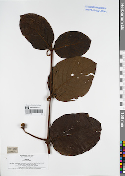
LE 01077492
Uncaria lanosa Wall. at 26.03.2006
Collectors: N.V. Tap; N.V. Trai Field collecting number: HLF6081. Collection date: 26.03.2006. Administrative regions: VN - Tinh Quang Tri. Groups of specimens: L. V. Averyanov specimens; L. V. Averyanov herbarium; Соглашение Минобрнауки №075-15-2021-1056Original label text:Vietnam, prov. Quang Tri, Da Krong
Rubiaceae
Uncaria lanosa Wall.
26.03.2006
HLF 6081
N.Tap, N.V.Trai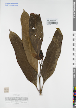
LE 01077493
Chassalia curviflora (Wall.) Thwaites det. Averyanov, Leonid Vladimirovich at 13.03.2013
Collectors: Tien Hiep Nguyen; Averyanov, Leonid Vladimirovich; et al. Field collecting number: LA-VN338. Collection date: 13.03.2013. Administrative regions: LA - Vientiane Province. Groups of specimens: L. V. Averyanov specimens; L. V. Averyanov herbarium; Соглашение Минобрнауки №075-15-2021-1056Original label text:FLORA OF LAOS
Rubiaceae
Chassalia curviflora
Vientiane Prov., Vang Vieng Distr., Phoudindeng village, 1-2 5 km to the E of Vang Vieng town around point 18°57′48.7”N 102°27′34.0”E.
Dry broad-leaved secondary evergreen forest with bamboo on low hills composed by shale at elevation about 400 m.
Undershrub 1-2 m tall in shady slope. Flower buds white with purple tint. Not rare.
LA-VN 338 13 March 2013
Coll.: N.T.Hiep, L.Averyanov, S.Lanorsavanh, N.S.Khang, P.V.The, S.Lorphengsy
Coordinates (geographic position): 18° 57′ 48.7″ N, 102° 27′ 34″ E ±1000 mRecord creation: 2021-11-24, Tatiana Maisak, PhotoScan D2. Processing status: work_status_1Citation: Specimen LE 01077493 // Virtual herbarium of Komarov Botanical Institute RAS — http://re.herbariumle.ru/01077493Rubiaceae
Chassalia curviflora
Vientiane Prov., Vang Vieng Distr., Phoudindeng village, 1-2 5 km to the E of Vang Vieng town around point 18°57′48.7”N 102°27′34.0”E.
Dry broad-leaved secondary evergreen forest with bamboo on low hills composed by shale at elevation about 400 m.
Undershrub 1-2 m tall in shady slope. Flower buds white with purple tint. Not rare.
LA-VN 338 13 March 2013
Coll.: N.T.Hiep, L.Averyanov, S.Lanorsavanh, N.S.Khang, P.V.The, S.Lorphengsy
LE 01077494
Spiradiclis loana R.J.Wang det. Averyanov, Leonid Vladimirovich at 08.11.2013
Collectors: Averyanov, Leonid Vladimirovich; et al. Field collecting number: CPC6915. Collection date: 08.11.2013. Administrative regions: VN - Tinh Thanh Hoa. Groups of specimens: L. V. Averyanov specimens; L. V. Averyanov herbarium; Соглашение Минобрнауки №075-15-2021-1056Original label text:FLORA OF VIETNAM NEW
Rubiaceae
Spiradiclis loana R. J. Wang
Thanh Hoa Prov., Thuong Xuan Distr., Van Xuan Municipality, Hang Cao village, Xuan Lien Natural Reserve.
Remnants of primary and secondary broad-leaved evergreen forest on highly eroded rocky limestone hills at elevation 100-200 m a.s.l. around point 19°50′47.2″N 105°14′42.7″E.
Lithophytic herb on vertical shady cliff. Locally common.
8 November 2013 CPC 6915
Coll.: L.Averyanov, N.T.Hiep, N.S.Khang, N.D.Thang, L.D.Qui
Coordinates (geographic position): 19° 50′ 47.2″ N, 105° 14′ 42.7″ E ±1000 mRecord creation: 2021-11-24, Tatiana Maisak, PhotoScan D2. Processing status: work_status_1Citation: Specimen LE 01077494 // Virtual herbarium of Komarov Botanical Institute RAS — http://re.herbariumle.ru/01077494Rubiaceae
Spiradiclis loana R. J. Wang
Thanh Hoa Prov., Thuong Xuan Distr., Van Xuan Municipality, Hang Cao village, Xuan Lien Natural Reserve.
Remnants of primary and secondary broad-leaved evergreen forest on highly eroded rocky limestone hills at elevation 100-200 m a.s.l. around point 19°50′47.2″N 105°14′42.7″E.
Lithophytic herb on vertical shady cliff. Locally common.
8 November 2013 CPC 6915
Coll.: L.Averyanov, N.T.Hiep, N.S.Khang, N.D.Thang, L.D.Qui
LE 01077495
Tarenna annamensis Pit. at 26.03.2006
Collectors: N.V. Tap; N.V. Trai Field collecting number: HLF6082. Collection date: 26.03.2006. Administrative regions: VN - Tinh Quang Tri. Groups of specimens: L. V. Averyanov specimens; L. V. Averyanov herbarium; Соглашение Минобрнауки №075-15-2021-1056Original label text:Vietnam, prov. Quang Tri, Da Krong
Record creation: 2021-11-24, Tatiana Maisak, PhotoScan D2. Processing status: work_status_1Citation: Specimen LE 01077495 // Virtual herbarium of Komarov Botanical Institute RAS — http://re.herbariumle.ru/01077495Rubiaceae
Tarenna annamensis Pit.
26.03.2006
HLF 6082
N.Tap, N.V.Trai
LE 01077496
Urophyllum villosum Wall. at 26.03.2006
Collectors: N.V. Tap; N.V. Trai Field collecting number: HLF6087. Collection date: 26.03.2006. Administrative regions: VN - Tinh Quang Tri. Groups of specimens: L. V. Averyanov specimens; L. V. Averyanov herbarium; Соглашение Минобрнауки №075-15-2021-1056Original label text:Vietnam, prov. Quang Tri, Da Krong
Rubiaceae
Urophyllum villosum Wall.
26.03.2006
HLF 6087
N.Tap, N.V.Trai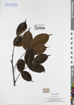
LE 01077497
Zanthoxylum nitidum (Roxb.) DC. at 26.03.2006
Collectors: N.V. Tap; N.V. Trai Field collecting number: HLF6089. Collection date: 26.03.2006. Administrative regions: VN - Tinh Quang Tri. Groups of specimens: L. V. Averyanov specimens; L. V. Averyanov herbarium; Соглашение Минобрнауки №075-15-2021-1056Original label text:Vietnam, prov. Quang Tri, Da Krong
Rubiaceae
Zanthoxylum nitidum (Roxb.) DC.
26.03.2006
HLF 6089
N.Tap, N.V.Trai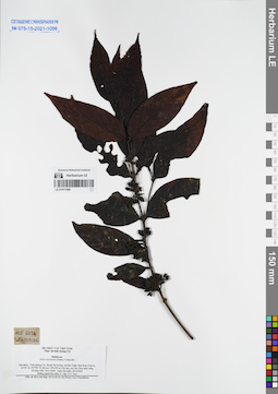
LE 01077498
Aidia oxyodonta (Drake) T.Yamaz. at 26.03.2006
Collectors: N.V. Tap; N.V. Trai Field collecting number: HLF6096. Collection date: 26.03.2006. Administrative regions: VN - Tinh Quang Tri. Groups of specimens: L. V. Averyanov specimens; L. V. Averyanov herbarium; Соглашение Минобрнауки №075-15-2021-1056Original label text:Vietnam, prov. Quang Tri, Da Krong
Rubiaceae
Aidia oxyodonta (Drake) T.Yamaz.
26.03.2006
HLF 6096
N.Tap, N.V.Trai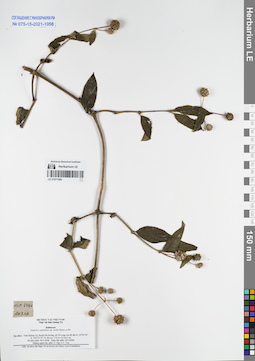
LE 01077499
Hedyotis capitellata G.Don var. mollis (Pit.) T.N.Ninh at 20.03.2006
Collectors: N.V. Tap; N.V. Trai Field collecting number: HLF6046. Collection date: 20.03.2006. Administrative regions: VN - Tinh Quang Tri. Groups of specimens: L. V. Averyanov specimens; L. V. Averyanov herbarium; Соглашение Минобрнауки №075-15-2021-1056Original label text:Vietnam, prov. Quang Tri, Da Krong
Record creation: 2021-11-24, Tatiana Maisak, PhotoScan D2. Processing status: work_status_1Citation: Specimen LE 01077499 // Virtual herbarium of Komarov Botanical Institute RAS — http://re.herbariumle.ru/01077499Rubiaceae
Hedyotis capitellata var. mollis (Pierre ex Pit.) Tran Ngoc Ninh
20.03.2006
HLF 6046
N.Tap, N.V.Trai
LE 01077500
Mussaenda cambodiana Pit. at 20.03.2006
Collectors: N.V. Tap; N.V. Trai Field collecting number: HLF6038. Collection date: 20.03.2006. Administrative regions: VN - Tinh Quang Tri. Groups of specimens: L. V. Averyanov specimens; L. V. Averyanov herbarium; Соглашение Минобрнауки №075-15-2021-1056Original label text:Vietnam, prov. Quang Tri, Da Krong
Rubiaceae
Mussaenda cambodiana Pierre ex Pit.
20.03.2006
HLF 6038
N.Tap, N.V.Trai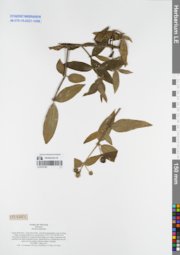
LE 01077501
Hedyotis capitellata Wall. det. Averyanov, Leonid Vladimirovich at 02.05.2011
Collectors: Averyanov, Leonid Vladimirovich; et al. Field collecting number: CPC2662. Collection date: 02.05.2011. Administrative regions: VN - Tinh Quang Binh. Groups of specimens: L. V. Averyanov specimens; L. V. Averyanov herbarium; Соглашение Минобрнауки №075-15-2021-1056Original label text:FLORA OF VIETNAM
Rubiaceae
Hedyotis capitellata
Quang Binh Prov., Tuyen Hoa Distr., Lam Hoa municipality, near Ca Tang bridge crossing Gianh River, around point 17°57′31”N 105°48′43”E.
Secondary broadleaved evergreen forest along river valley composed with stratified soft shale limestone at elev. about 60 m a.s.l.
Herbaceous vine on open wet river slopes. Flowers white. Common.
CPC 2662 2 May 2011
Coll.: L.Averyanov, P.K.Loc, N.Q.Hieu, P.V.The, N.T.Vinh.
Coordinates (geographic position): 17° 57′ 31″ N, 105° 48′ 43″ E ±1000 mRecord creation: 2021-11-24, Tatiana Maisak, PhotoScan D2. Processing status: work_status_1Citation: Specimen LE 01077501 // Virtual herbarium of Komarov Botanical Institute RAS — http://re.herbariumle.ru/01077501Rubiaceae
Hedyotis capitellata
Quang Binh Prov., Tuyen Hoa Distr., Lam Hoa municipality, near Ca Tang bridge crossing Gianh River, around point 17°57′31”N 105°48′43”E.
Secondary broadleaved evergreen forest along river valley composed with stratified soft shale limestone at elev. about 60 m a.s.l.
Herbaceous vine on open wet river slopes. Flowers white. Common.
CPC 2662 2 May 2011
Coll.: L.Averyanov, P.K.Loc, N.Q.Hieu, P.V.The, N.T.Vinh.
LE 01077502
Psychotria rubra (Lour.) Poir. det. Averyanov, Leonid Vladimirovich at 02.05.2011
Collectors: Averyanov, Leonid Vladimirovich; et al. Field collecting number: CPC2637. Collection date: 02.05.2011. Administrative regions: VN - Tinh Quang Binh. Groups of specimens: L. V. Averyanov specimens; L. V. Averyanov herbarium; Соглашение Минобрнауки №075-15-2021-1056Original label text:FLORA OF VIETNAM
Rubiaceae
Psychotyria rubra
Quang Binh Prov., Tuyen Hoa Distr., Lam Hoa municipality, near Ca Tang bridge crossing Gianh River, around point 17°57′31”N 105°48′43”E.
Secondary broadleaved evergreen forest along river valley composed with stratified soft shale limestone at elev. about 60 m a.s.l.
Treelet 3-4 m tall. Flowers greenish. Common.
CPC 2637 2 May 2011
Coll.: L.Averyanov, P.K.Loc, N.Q.Hieu, P.V.The, N.T.Vinh.
Coordinates (geographic position): 17° 57′ 31″ N, 105° 48′ 43″ E ±1000 mRecord creation: 2021-11-24, Tatiana Maisak, PhotoScan D2. Processing status: work_status_1Citation: Specimen LE 01077502 // Virtual herbarium of Komarov Botanical Institute RAS — http://re.herbariumle.ru/01077502Rubiaceae
Psychotyria rubra
Quang Binh Prov., Tuyen Hoa Distr., Lam Hoa municipality, near Ca Tang bridge crossing Gianh River, around point 17°57′31”N 105°48′43”E.
Secondary broadleaved evergreen forest along river valley composed with stratified soft shale limestone at elev. about 60 m a.s.l.
Treelet 3-4 m tall. Flowers greenish. Common.
CPC 2637 2 May 2011
Coll.: L.Averyanov, P.K.Loc, N.Q.Hieu, P.V.The, N.T.Vinh.
LE 01077503
Uncaria macrophylla Wall. det. Averyanov, Leonid Vladimirovich at 09.05.2015
Collectors: Nguyen Quang Hieu; Tien Hiep Nguyen; et al. Field collecting number: CPC7849. Collection date: 09.05.2015. Administrative regions: VN - Tinh Ha Giang. Groups of specimens: L. V. Averyanov specimens; L. V. Averyanov herbarium; Соглашение Минобрнауки №075-15-2021-1056Original label text:FLORA OF VIETNAM
Rubiaceae
Uncaria macrophylla Wall.
Verde.Ha Giang Prov., Vi Xuyen Distr., Tung Ba municipality, Khau Ca NR.
Primary broad-leaved humid evergreen forest on very steep slopes and along rocky ridge composed with solid crystalline highly eroded limestone at elevation 700-1150 m a.s.l. around point 22°50′43.9″N 105°07′18.5″E.
Shrub climbering 4-5 m high. Common.
09 May 2015 CPC 7849 Coll.: N.Q. Hieu, N.T.Hiep, T.B. Ngan, C.Q. Ngan, D.K. Harder, C. P. Tuy, G.C.Pao
Coordinates (geographic position): 22° 50′ 43.9″ N, 105° 7′ 18.5″ E ±1000 mRecord creation: 2021-11-24, Tatiana Maisak, PhotoScan D2. Processing status: work_status_1Citation: Specimen LE 01077503 // Virtual herbarium of Komarov Botanical Institute RAS — http://re.herbariumle.ru/01077503Rubiaceae
Uncaria macrophylla Wall.
Verde.Ha Giang Prov., Vi Xuyen Distr., Tung Ba municipality, Khau Ca NR.
Primary broad-leaved humid evergreen forest on very steep slopes and along rocky ridge composed with solid crystalline highly eroded limestone at elevation 700-1150 m a.s.l. around point 22°50′43.9″N 105°07′18.5″E.
Shrub climbering 4-5 m high. Common.
09 May 2015 CPC 7849 Coll.: N.Q. Hieu, N.T.Hiep, T.B. Ngan, C.Q. Ngan, D.K. Harder, C. P. Tuy, G.C.Pao
LE 01077504
Mussaenda hossei Craib det. Averyanov, Leonid Vladimirovich at 03.04.2015
Collectors: Tien Hiep Nguyen; Averyanov, Leonid Vladimirovich; et al. Field collecting number: LA-VN941. Collection date: 03.04.2015. Administrative regions: LA - Xiangkhouang. Groups of specimens: L. V. Averyanov specimens; L. V. Averyanov herbarium; Соглашение Минобрнауки №075-15-2021-1056Original label text:FLORA OF LAOS
Rubiaceae
Mussaenda hossei Craib ex Hosseus
Xiangkhouang Prov., Peak Distr., Khoang village, Pa Khao mt., around point 19°33′02.2′N 103°39′56.3′E.
Primary and secondary broad-leaved evergreen dry forest on solid rocky highly eroded limestone at elev. 1200-1450 m a.s.l.
Scandent shrub 2-3 m long in rather open places. Inflorescence bracts white, flowers yellow. Very common.
LA-VN 941 3 April 2015
Coll.: N.T.Hiep, L.Averyanov, N.S.Khang, N.Q.Hieu, T.Maisak, Pheng Phengsintham.
Coordinates (geographic position): 19° 33′ 2.2″ N, 103° 39′ 56.3″ E ±1000 mRecord creation: 2021-11-24, Tatiana Maisak, PhotoScan D2. Processing status: work_status_1Citation: Specimen LE 01077504 // Virtual herbarium of Komarov Botanical Institute RAS — http://re.herbariumle.ru/01077504Rubiaceae
Mussaenda hossei Craib ex Hosseus
Xiangkhouang Prov., Peak Distr., Khoang village, Pa Khao mt., around point 19°33′02.2′N 103°39′56.3′E.
Primary and secondary broad-leaved evergreen dry forest on solid rocky highly eroded limestone at elev. 1200-1450 m a.s.l.
Scandent shrub 2-3 m long in rather open places. Inflorescence bracts white, flowers yellow. Very common.
LA-VN 941 3 April 2015
Coll.: N.T.Hiep, L.Averyanov, N.S.Khang, N.Q.Hieu, T.Maisak, Pheng Phengsintham.
LE 01077505
Mussaenda shikokiana Makino ⟮prelim. ID⟯ det. Averyanov, Leonid Vladimirovich at 14.11.2014
Collectors: Averyanov, Leonid Vladimirovich; et al. Field collecting number: CPC7449. Collection date: 14.11.2014. Administrative regions: VN - Tinh Ha Giang. Groups of specimens: L. V. Averyanov specimens; L. V. Averyanov herbarium; Соглашение Минобрнауки №075-15-2021-1056Original label text:FLORA OF VIETNAM
Rubiaceae
Mussaenda sikokiana?
Border area between Phieng Luong municipality (Ha Giang Prov., Bac Me Distr.) and Sinh Long municipalitiy (Tuen Quang Prov., Na Hang Distr.).
Primary broad-leaved humid evergreen and mixed forest on very steep slopes and along rocky ridge composed with solid crystalline highly eroded limestone at elevation 1100-1170 m a.s.l. around point 22°38′24.3″N 105°20′21.3″E.
Scandent shrub about 2 m tall on slopes and on base of rocky limestone mountain. Fruits dark green. Not common.
14 November 2014 CPC 7449
Coll.: L.Averyanov, N.T.Hiep, N.S.Khang, T.Maisak, L.Osinovetz
Coordinates (geographic position): 22° 38′ 24.3″ N, 105° 20′ 21.3″ E ±1000 mRecord creation: 2021-11-24, Tatiana Maisak, PhotoScan D2. Processing status: work_status_1Citation: Specimen LE 01077505 // Virtual herbarium of Komarov Botanical Institute RAS — http://re.herbariumle.ru/01077505Rubiaceae
Mussaenda sikokiana?
Border area between Phieng Luong municipality (Ha Giang Prov., Bac Me Distr.) and Sinh Long municipalitiy (Tuen Quang Prov., Na Hang Distr.).
Primary broad-leaved humid evergreen and mixed forest on very steep slopes and along rocky ridge composed with solid crystalline highly eroded limestone at elevation 1100-1170 m a.s.l. around point 22°38′24.3″N 105°20′21.3″E.
Scandent shrub about 2 m tall on slopes and on base of rocky limestone mountain. Fruits dark green. Not common.
14 November 2014 CPC 7449
Coll.: L.Averyanov, N.T.Hiep, N.S.Khang, T.Maisak, L.Osinovetz
LE 01077821
Psychotria serpens L.
Collectors: Unknown Field collecting number: LX-VN 3319. Collection date: 21.12.1986. Administrative regions: VN - Thanh Pho Hai Phong. Groups of specimens: L. V. Averyanov specimens; L. V. Averyanov herbarium; Соглашение Минобрнауки №075-15-2021-1056; Flora of VietnamOriginal label text:FLORA OF VIETNAM
Record creation: 2022-04-19, Tatiana Maisak, PhotoScan D2. Processing status: work_status_1Citation: Specimen LE 01077821 // Virtual herbarium of Komarov Botanical Institute RAS — http://re.herbariumle.ru/01077821Rubiaceae
Psychotria serpens L.
Hai Phong Prov.
LX-VN 3319, 21.12.1986.
LE 01077822
Psychotria rubra (Lour.) Poir. at 01.1973
Collectors: Unknown Field collecting number: N 0291. Collection date: 15.10.1960. Administrative regions: VN - Vietnam. Groups of specimens: L. V. Averyanov specimens; L. V. Averyanov herbarium; Соглашение Минобрнауки №075-15-2021-1056Original label text:FLORA OF VIETNAM
Rubiaceae
Record creation: 2022-04-19, Tatiana Maisak, PhotoScan D2. Processing status: work_status_1Citation: Specimen LE 01077822 // Virtual herbarium of Komarov Botanical Institute RAS — http://re.herbariumle.ru/01077822Rubiaceae
Psychotria rubra (Lour.) Poir.
N 0291, 15.10.1960
LE 01077823
Psychotria serpens L. at 02.1973
Collectors: Unknown Field collecting number: N 0250. Collection date: 15.10.1960. Administrative regions: VN - Vietnam. Groups of specimens: L. V. Averyanov specimens; L. V. Averyanov herbarium; Соглашение Минобрнауки №075-15-2021-1056Original label text:FLORA OF VIETNAM
Rubiaceae
Record creation: 2022-04-19, Tatiana Maisak, PhotoScan D2. Processing status: work_status_1Citation: Specimen LE 01077823 // Virtual herbarium of Komarov Botanical Institute RAS — http://re.herbariumle.ru/01077823Rubiaceae
Psychotria serpens L.
N 0250, 15.10.1960
LE 01077824
Psychotria yunnanensis Hutch. det. Tran Ngoc Thinh at 01.1973
Collectors: Unknown Field collecting number: N 0598. Collection date: 27.10.1960. Administrative regions: VN - Vietnam. Groups of specimens: L. V. Averyanov specimens; L. V. Averyanov herbarium; Соглашение Минобрнауки №075-15-2021-1056Original label text:FLORA OF VIETNAM
Rubiaceae
Record creation: 2022-04-19, Tatiana Maisak, PhotoScan D2. Processing status: work_status_1Citation: Specimen LE 01077824 // Virtual herbarium of Komarov Botanical Institute RAS — http://re.herbariumle.ru/01077824Rubiaceae
Psychotria yunnanensis Hutch.
Vietnam.
N 0598, 27.10.1960
Det. Tran Ngoc Thinh at 01.1973
LE 01077825
Psychotria yunnanensis Hutch. det. Tran Ngoc Thinh at 01.1973
Collectors: Unknown Field collecting number: N 0598. Collection date: 27.10.1960. Administrative regions: VN - Vietnam. Groups of specimens: L. V. Averyanov specimens; L. V. Averyanov herbarium; Соглашение Минобрнауки №075-15-2021-1056Original label text:FLORA OF VIETNAM
Rubiaceae
Record creation: 2022-04-19, Tatiana Maisak, PhotoScan D2. Processing status: work_status_1Citation: Specimen LE 01077825 // Virtual herbarium of Komarov Botanical Institute RAS — http://re.herbariumle.ru/01077825Rubiaceae
Psychotria yunnanensis Hutch.
Vietnam.
N 0598, 27.10.1960
Det. Tran Ngoc Thinh at 01.1973
LE 01077826
Psychotria rubra (Lour.) Poir. det. Tran Ngoc Thinh at 01.1973
Collectors: Unknown Field collecting number: N 0518. Collection date: 23.10.1960. Administrative regions: VN - Vietnam. Groups of specimens: L. V. Averyanov specimens; L. V. Averyanov herbarium; Соглашение Минобрнауки №075-15-2021-1056Original label text:FLORA OF VIETNAM
Rubiaceae
Record creation: 2022-04-19, Tatiana Maisak, PhotoScan D2. Processing status: work_status_1Citation: Specimen LE 01077826 // Virtual herbarium of Komarov Botanical Institute RAS — http://re.herbariumle.ru/01077826Rubiaceae
Psychotria rubra (Lour.) Poir.
Vietnam.
N 0518, 23.10.1960
Det. Tran Ngoc Thinh at 01.1973
LE 01077827
Psychotria rubra (Lour.) Poir. det. Tran Ngoc Thinh at 01.1973
Collectors: Unknown Field collecting number: N 0518. Collection date: 23.10.1960. Administrative regions: VN - Vietnam. Groups of specimens: L. V. Averyanov specimens; L. V. Averyanov herbarium; Соглашение Минобрнауки №075-15-2021-1056Original label text:FLORA OF VIETNAM
Rubiaceae
Record creation: 2022-04-19, Tatiana Maisak, PhotoScan D2. Processing status: work_status_1Citation: Specimen LE 01077827 // Virtual herbarium of Komarov Botanical Institute RAS — http://re.herbariumle.ru/01077827Rubiaceae
Psychotria rubra (Lour.) Poir.
Vietnam.
N 0518, 23.10.1960
Det. Tran Ngoc Thinh at 01.1973