View
Add
Copy
Edit
Delete
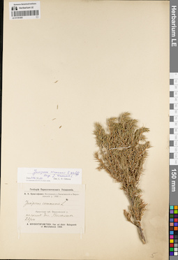
LE 01191491
Juniperus niemannii E.L. Wolf ⟨close to Juniperus communis L.⟩ det. Orlova, Larisa Vladimirovna at 11.06.2022
Additional identifications: Juniperus communis L. det. Kryshtofowicz, African Nikolaevich at 1908 Collectors: Kryshtofowicz, African Nikolaevich Collection date: 22.07.1908. Administrative regions: RU - Irkutskaya Oblast' - Zhigalovskiy Rayon. Place of collection: склон долины р. Балыхта.Expedition: А.Н. Криштофович: Экспедиция в Балаганский и Верхоленский у. 1908 г. (1908)Groups of specimens: Образцы сектора Сибири и Дальнего Востока России; Соглашение Минобрнауки №075-15-2021-1056; Гербарий Переселенческого УправленияOriginal label text:Гербарий Переселенческого Управления. А.Н. Криштофович: Экспедиция в Балаганский и Верхоленский у. 1908 г. Juniperus communis L. Иркутская губ. Верхоленский у. на склоне дол. Балыхты. 22/VII. A. Kryschtofowitsch: Iter ad distr. Balagansk et Wercholensk 1908
Landscape in location of collection: склон долины рекиCoordinates (geographic position): 54° 30′ 20.06″ N, 104° 19′ 3.52″ E ±5000 mRecord creation: 2022-06-16, Larisa Orlova, PhotoScan D2Citation: Specimen LE 01191491 // Virtual herbarium of Komarov Botanical Institute RAS — http://re.herbariumle.ru/01191491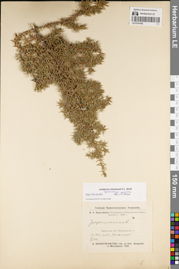
LE 01191492
Juniperus niemannii E.L. Wolf ⟨intermediate forma⟩ det. Orlova, Larisa Vladimirovna at 11.06.2022
Additional identifications: Juniperus communis L. det. Kryshtofowicz, African Nikolaevich at 1908 Collectors: Kryshtofowicz, African Nikolaevich Collection date: 02.08.1908. Administrative regions: RU - Irkutskaya Oblast' - Zhigalovskiy Rayon. Place of collection: р. Полканка (?), дно пади "Полканка".Expedition: А.Н. Криштофович: Экспедиция в Балаганский и Верхоленский у. 1908 г. (1908)Groups of specimens: Образцы сектора Сибири и Дальнего Востока России; Соглашение Минобрнауки №075-15-2021-1056; Гербарий Переселенческого УправленияOriginal label text:Гербарий Переселенческого Управления. А.Н. Криштофович: Экспедиция в Балаганский и Верхоленский у. 1908 г. Juniperus communis L. Иркутская губ. Верхоленский у. на дне пади "Полканка". 2/VIII. A. Kryschtofowitsch: Iter ad distr. Balagansk et Wercholensk 1908
Landscape in location of collection: дно падиCoordinates (geographic position): 54° 57′ 9.36″ N, 104° 36′ 23.49″ E ±10000 mRecord creation: 2022-06-16, Larisa Orlova, PhotoScan D2Citation: Specimen LE 01191492 // Virtual herbarium of Komarov Botanical Institute RAS — http://re.herbariumle.ru/01191492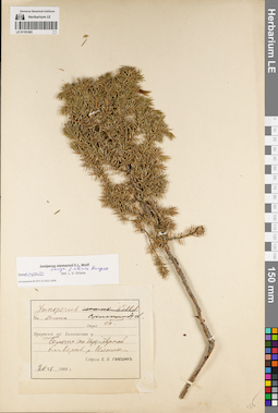
LE 01191493
Juniperus niemannii E.L. Wolf ⟨close to Juniperus sibirica Burgsd.⟩ det. Orlova, Larisa Vladimirovna at 11.06.2022
Additional identifications: Juniperus nana Willd. det. Ganeschin, Sergej Sergejewitsch at 1909; Juniperus communis L. det. Ganeschin, Sergej Sergejewitsch Collectors: Ganeschin, Sergej Sergejewitsch Collection date: 20.06.1909. Administrative regions: RU - Irkutskaya Oblast' - Nizhneilimskiy Rayon. Place of collection: болото по берегу р. Черная близ верховьев р. Илим.Groups of specimens: Образцы сектора Сибири и Дальнего Востока России; Соглашение Минобрнауки №075-15-2021-1056Original label text:Juniperus [nana Willd. - crossed out] communis L. На болоте. Опред. С. Г[анешин]. Иркутской губ. Балаганского у. Болото по бер. Черной бл. верхов. р. Илима. Собрал С.С. Ганешин. 20 VI 1909 г
Habitat / plant community in location of collecting: болотоCoordinates (geographic position): 56° 25′ 58.99″ N, 103° 48′ 16.01″ E ±20000 mRecord creation: 2022-06-16, Larisa Orlova, PhotoScan D2Citation: Specimen LE 01191493 // Virtual herbarium of Komarov Botanical Institute RAS — http://re.herbariumle.ru/01191493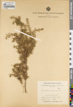
LE 01191494
Juniperus communis L. det. Kryshtofowicz, African Nikolaevich at 1910
Collectors: Kryshtofowicz, African Nikolaevich Collection date: 13.07.1910. Administrative regions: RU - Irkutskaya Oblast'. Place of collection: Нижнеудинский уезд, сырая болотная падь близ Усть-Ия (р. Ия?).Expedition: А.Н. Криштофович: Экспедиция в Око-Ангарский край. 1910 г. (1910)Groups of specimens: Образцы сектора Сибири и Дальнего Востока России; Соглашение Минобрнауки №075-15-2021-1056; Гербарий Переселенческого УправленияOriginal label text:Гербарий Переселенческого Управления. А.Н. Криштофович. Экспедиция в Око-Ангарский край 1910 г. Juniperus communis L. Иркутская губ. Нижнеуд. у. сырая болот. падь близ Усть-Ии. 13/VII. 5. A. Kristofovic. Iter ocaensi-angarense. 1910
Landscape in location of collection: сырая болотная падьCoordinates (geographic position): 53° 59′ 9″ N, 100° 2′ 25.58″ E ±300000 mRecord creation: 2022-06-16, Larisa Orlova, PhotoScan D2Citation: Specimen LE 01191494 // Virtual herbarium of Komarov Botanical Institute RAS — http://re.herbariumle.ru/01191494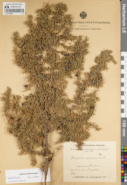
LE 01191495
Juniperus sibirica Burgsd. det. Orlova, Larisa Vladimirovna at 11.06.2022
Additional identifications: Juniperus communis L. det. Kryshtofowicz, African Nikolaevich at 1910 Collectors: Kryshtofowicz, African Nikolaevich Collection date: 03.07.1910. Administrative regions: RU - Irkutskaya Oblast' - Balaganskiy Rayon. Place of collection: тайга по р. Егирма.Expedition: А.Н. Криштофович: Экспедиция в Око-Ангарский край. 1910 г. (1910)Groups of specimens: Образцы сектора Сибири и Дальнего Востока России; Соглашение Минобрнауки №075-15-2021-1056; Гербарий Переселенческого УправленияOriginal label text:Гербарий Переселенческого Управления. А.Н. Криштофович. Экспедиция в Око-Ангарский край 1910 г. Juniperus communis L. Иркутская губ. Балаган. у. тайга по Егирме. 3/VII. 5. A. Kristofovic. Iter ocaensi-angarense. 1910
Habitat / plant community in location of collecting: тайгаCoordinates (geographic position): 55° 7′ 5.19″ N, 102° 58′ 37.81″ E ±30000 mRecord creation: 2022-06-16, Larisa Orlova, PhotoScan D2Citation: Specimen LE 01191495 // Virtual herbarium of Komarov Botanical Institute RAS — http://re.herbariumle.ru/01191495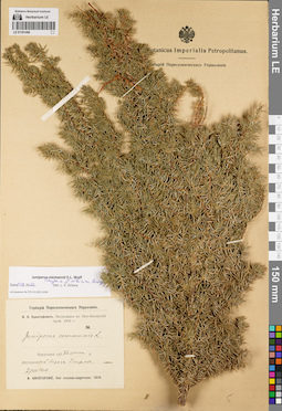
LE 01191496
Juniperus niemannii E.L. Wolf ⟨close to Juniperus sibirica Burgsd.⟩ det. Orlova, Larisa Vladimirovna at 11.06.2022
Additional identifications: Juniperus communis L. det. Kryshtofowicz, African Nikolaevich at 1910 Collectors: Kryshtofowicz, African Nikolaevich Collection date: 02.07.1910. Administrative regions: RU - Irkutskaya Oblast' - Balaganskiy Rayon. Place of collection: таежный берег р. Егирма.Expedition: А.Н. Криштофович: Экспедиция в Око-Ангарский край. 1910 г. (1910)Groups of specimens: Образцы сектора Сибири и Дальнего Востока России; Соглашение Минобрнауки №075-15-2021-1056; Гербарий Переселенческого УправленияOriginal label text:Гербарий Переселенческого Управления. А.Н. Криштофович. Экспедиция в Око-Ангарский край 1910 г. Juniperus communis L. Иркутская губ. Балаган. у. таежный берег Егирмы. 2/VII. 5. A. Kristofovic. Iter ocaensi-angarense. 1910
Landscape in location of collection: берег рекиHabitat / plant community in location of collecting: тайгаCoordinates (geographic position): 55° 6′ 8.56″ N, 103° 4′ 12.72″ E ±30000 mRecord creation: 2022-06-16, Larisa Orlova, PhotoScan D2Citation: Specimen LE 01191496 // Virtual herbarium of Komarov Botanical Institute RAS — http://re.herbariumle.ru/01191496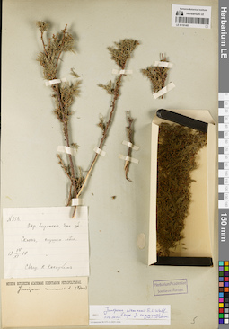
LE 01191497
Juniperus niemannii E.L. Wolf ⟨close to Juniperus communis L.⟩ det. Orlova, Larisa Vladimirovna at 11.06.2022
Additional identifications: Juniperus communis L. det. Krylov, Porphyriy Nikitich Collectors: Kokoukhin. K. Field collecting number: 356. Collection date: 14.06.1910. Administrative regions: RU - Irkutskaya Oblast' - Kirenskiy Rayon. Place of collection: окрестности г. Киренск, склон, опушка леса.Groups of specimens: Образцы сектора Сибири и Дальнего Востока России; Соглашение Минобрнауки №075-15-2021-1056Original label text:N 356. Окр. Киренска, Ирк. губ. Склон, опушка леса. 14/VI 1910. Свящ. К. Кокоухин
Landscape in location of collection: склонHabitat / plant community in location of collecting: опушка лесаCoordinates (geographic position): 57° 46′ 32.62″ N, 108° 6′ 38.97″ E ±10000 mRecord creation: 2022-06-16, Larisa Orlova, PhotoScan D2Citation: Specimen LE 01191497 // Virtual herbarium of Komarov Botanical Institute RAS — http://re.herbariumle.ru/01191497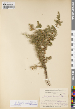
LE 01191498
Juniperus niemannii E.L. Wolf ⟨close to Juniperus communis L.⟩ det. Orlova, Larisa Vladimirovna at 11.06.2022
Additional identifications: Juniperus communis L. det. Drobow, Vasilii Petrovich at 1909 Collectors: Drobow, Vasilii Petrovich Field collecting number: 214. Collection date: 11.07.1909. Administrative regions: RU - Irkutskaya Oblast' - Kazachinsko-Lenskiy Rayon. Place of collection: левый берег р. Киренга близ д. Ханда.Expedition: В.П. Дробов: Лено-Киренгская Экспедиция 1909 г. (1909)Groups of specimens: Образцы сектора Сибири и Дальнего Востока России; Соглашение Минобрнауки №075-15-2021-1056; Гербарий Переселенческого УправленияOriginal label text:Гербарий Переселенческого Управления. В.П. Дробов: Лено-Киренгская Экспедиция 1909 г. № 214. Juniperus communis L. Иркутская губ. Верхоленский уезд. Сосново-лиственничное сообщество со вторым ярусом из ели и кедра на левом берегу р. Киренги близ д. Ханда. W.P. Drobow: Iter ad flum. Lena et Kirenga 1909.11.VII
Landscape in location of collection: берег рекиHabitat / plant community in location of collecting: сосново-лиственничное сообщество со вторым ярусом из ели и кедраCoordinates (geographic position): 54° 59′ 52.91″ N, 107° 13′ 52.59″ E ±3000 mRecord creation: 2022-06-16, Larisa Orlova, PhotoScan D2Citation: Specimen LE 01191498 // Virtual herbarium of Komarov Botanical Institute RAS — http://re.herbariumle.ru/01191498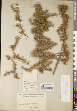
LE 01191499
Juniperus niemannii E.L. Wolf ⟨intermediate forma⟩ det. Orlova, Larisa Vladimirovna at 11.06.2022
Additional identifications: Juniperus communis L. det. Krylov, Porphyriy Nikitich Collectors: Migutskij, V. Collection date: 05.1914. Place of collection: бассейн р. Нюя, у устья р. Оччугуй-Мурбайы (Малый Мурбай, приток р. Нюя), левый берег, склон каменистой горы.Groups of specimens: Образцы сектора Сибири и Дальнего Востока России; Соглашение Минобрнауки №075-15-2021-1056Object features: ЧастоOriginal label text:[1]У устья Малого Мурбая, притока р. Нюи. Лев. бер. На склоне каменистой горы. Часто N [2] Museum Botanicum Academiae Scientiarum Petropolitanae. Juniperus communis L. (Крыл.). Иркутская губ. Киренский у. В бассейне р. Нюи, левого прит. Лены. 1914.V Собр. В. Мигуцкий
Landscape in location of collection: склон каменистой горыCoordinates (geographic position): 60° 57′ 20.41″ N, 115° 9′ 4.28″ E ±3000 mRecord creation: 2022-06-16, Larisa Orlova, PhotoScan D2Citation: Specimen LE 01191499 // Virtual herbarium of Komarov Botanical Institute RAS — http://re.herbariumle.ru/01191499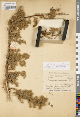
LE 01191502
Juniperus niemannii E.L. Wolf ⟨intermediate forma⟩ det. Orlova, Larisa Vladimirovna at 11.06.2022
Additional identifications: Juniperus communis L. det. Kusnezow, Nicolai Ivanovitch at 1910 Collectors: Kusnezow, Nicolai Ivanovitch Field collecting number: 206. Collection date: 08.06.1910. Administrative regions: RU - Irkutskaya Oblast' - Kachugskiy Rayon. Place of collection: долина р. Тутура, старая гарь около зимовья Челпанова.Expedition: Н.И. Кузнецов. Лено-Киренгская экспедиция Иркутской губ. 1910 г. (1910)Groups of specimens: Образцы сектора Сибири и Дальнего Востока России; Соглашение Минобрнауки №075-15-2021-1056; Гербарий Переселенческого УправленияOriginal label text:Гербарий Переселенческого Управления. Н.И. Кузнецов. Лено-Киренгская экспедиция Иркутской губ. 1910 г. № 206. 8/VI 1910 г. Juniperus communis L. Долина р. Тутуры. Старая гарь около зимовья Челпанова. N.I. Kusnezow: Iter Ircutense ad fl. Lena et Kirenga. 1910
Landscape in location of collection: долина рекиHabitat / plant community in location of collecting: старая гарьCoordinates (geographic position): 54° 23′ 11.62″ N, 106° 6′ 29.41″ E ±130000 mRecord creation: 2022-06-16, Larisa Orlova, PhotoScan D2Citation: Specimen LE 01191502 // Virtual herbarium of Komarov Botanical Institute RAS — http://re.herbariumle.ru/01191502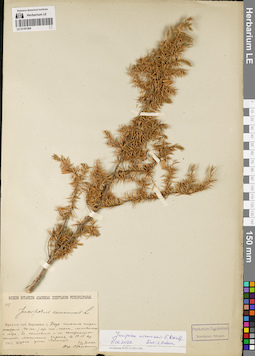
LE 01191504
Juniperus niemannii E.L. Wolf det. Orlova, Larisa Vladimirovna at 11.06.2022
Additional identifications: Juniperus communis L. det. Ganeschin, Sergej Sergejewitsch at 1911 Collectors: Dolenko. Gr. Field collecting number: 119. Collection date: 23.06.1911. Administrative regions: RU - Irkutskaya Oblast' - Ekhirit-Bulagatskiy Rayon. Place of collection: село Харат, в 13-16 км от улиса Заготуй, старое насаждение (90-100 лет) из ели, пихты, лиственницы и кедровой сосны, в котловине и на понижающихся склонах.Groups of specimens: Образцы сектора Сибири и Дальнего Востока России; Соглашение Минобрнауки №075-15-2021-1056Original label text:Museum Botanicum Academiae Scientiarum Petropolitanae. 119. Juniperus communis L. Иркутск. губ. Верхоленск. у. Под пологом старого насаждения (90-100 л.) из ели, пыхты, лиственницы и кедра, в котловине и на понижающихся склонах. Местность Харат, в 12-15 вер. от улиса Заготуя. 1911.VI.23. Гр. Доленко. Опр. С. Ганешин
Landscape in location of collection: в котловине и на понижающихся склонахHabitat / plant community in location of collecting: старое насаждение (90-100 лет) из ели, пихты, лиственницы и кедровой сосныCoordinates (geographic position): 52° 45′ 10.02″ N, 105° 3′ 38.92″ E ±5000 mRecord creation: 2022-06-16, Larisa Orlova, PhotoScan D2Citation: Specimen LE 01191504 // Virtual herbarium of Komarov Botanical Institute RAS — http://re.herbariumle.ru/01191504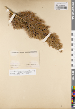
LE 01191525
Juniperus niemannii E.L. Wolf ⟨close to Juniperus communis L.⟩ det. Orlova, Larisa Vladimirovna at 09.07.2022
Collectors: Cherskie, I. and M. Collection date: 08.06.1892. Administrative regions: RU - Respublika Sakha (Yakutiya) - Srednekolymsky District. Place of collection: р. Колыма, между с. Верхнеколымск и с. Среднеколымск.Groups of specimens: Образцы сектора Сибири и Дальнего Востока России; Соглашение Минобрнауки №075-15-2021-1056Original label text:Museum Botanicum Academiae Scientiarum Petropolitanae. Восточн. Сибирь. Якут. Обл. Р. Колыма. Между Верхне-Колымском и Средне-Колымском. 8-VI-1892г. Собр. И. и М. Черские
Landscape in location of collection: берег рекиCoordinates (geographic position): 66° 45′ 19.16″ N, 152° 5′ 12.54″ E ±100000 mRecord creation: 2022-07-09, Larisa Orlova, PhotoScan D2. Part 1.Citation: Specimen LE 01191525 // Virtual herbarium of Komarov Botanical Institute RAS — http://re.herbariumle.ru/01191525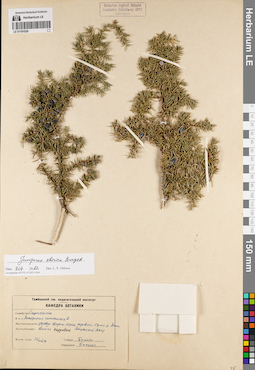
LE 01191526
Juniperus communis L. det. Bukhalo at 1971
Collectors: Bukhalo Collection date: 26.08.1971. Administrative regions: RU - Respublika Sakha (Yakutiya) - Oymyakonskiy District. Place of collection: дер. Тарын-Юрях (Тарын-Юрах), тайга кедровая.Groups of specimens: Образцы сектора Сибири и Дальнего Востока России; Соглашение Минобрнауки №075-15-2021-1056; Тамбовский гос. педагогический институт. Кафедра ботаникиOriginal label text:Тамбовский гос. педагогический институт. Кафедра ботаники. Семейство: Cupressaceae Вид: Juniperus communis L. Местонахождение: деревня Тарын-Юрах правого берега р. Лены Якутской АССР. Местообитание: тайга кедровая Время сбора: 26/VIII 71. Собрал Бухало Определил Бухало
Habitat / plant community in location of collecting: тайга кедроваяCoordinates (geographic position): 64° 15′ 22.42″ N, 142° 47′ 52.45″ E ±10000 mRecord creation: 2022-07-09, Larisa Orlova, PhotoScan D2. Part 1.Citation: Specimen LE 01191526 // Virtual herbarium of Komarov Botanical Institute RAS — http://re.herbariumle.ru/01191526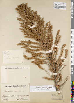
LE 01191532
Juniperus sibirica Burgsd. det. Orlova, Larisa Vladimirovna at 09.07.2022
Additional identifications: Juniperus communis L. det. Olenin Pavel Vasilievich at 1901 Collectors: Olenin Pavel Vasilievich Collection date: 27.07.1901. Administrative regions: RU - Respublika Sakha (Yakutiya). Subregion: Жиганский улус. Place of collection: р. Лена, с. Жиганск.Expedition: П.В. Оленин: Флора Якутской области (1900 -1902)Groups of specimens: Образцы сектора Сибири и Дальнего Востока России; Соглашение Минобрнауки №075-15-2021-1056Original label text:[1]27/VII. Жиганск [2] П.В. Оленин: Флора Якутской области. Juniperus communis. Верхоянск. окр. р. Лена. Жиганск. 1901 27/VII. Собр. П. Оленин
Landscape in location of collection: берег крупной рекиCoordinates (geographic position): 66° 46′ 3.29″ N, 123° 22′ 27.25″ E ±10000 mRecord creation: 2022-07-09, Larisa Orlova, PhotoScan D2. Part 1.Citation: Specimen LE 01191532 // Virtual herbarium of Komarov Botanical Institute RAS — http://re.herbariumle.ru/01191532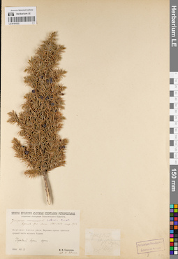
LE 01191533
Juniperus sibirica Burgsd. det. Unknown
Additional identifications: Juniperus communis L. det. Petrova, V. Collectors: Serpukhov, V.I. Collection date: 18.07.1926. Administrative regions: RU - Respublika Sakha (Yakutiya) - Aldanskiy Rayon. Subregion: Алданский улус. Place of collection: верховья правых притоков средней части верхнего Алдана, правый борт р. Эрга.Expedition: В.И. Серпухов. Алданская экспедиция Геологического Комитета (1926)Groups of specimens: Образцы сектора Сибири и Дальнего Востока России; Соглашение Минобрнауки №075-15-2021-1056Original label text:[1]Правый борт Эрги. 18/VII. ВС. [2] Museum Botanicum Academiae Scientiarum Petropolitanae. Алданская экспедиция Геологического Комитета. Juniperus [communis L. - crossed out] sibirica Burgsd. Крылов Фл. Алт. 1901-1914 стр. 1732 Якутская Автон. респ. Верховья правых притоков средней части верхнего Алдана. Правый борт Эрги. 1926 VII.18 В.И. Серпухов det. V. Petrova
Landscape in location of collection: берег рекиCoordinates (geographic position): 57° 40′ 28.1″ N, 127° 3′ 13.77″ E ±10000 mRecord creation: 2022-07-09, Larisa Orlova, PhotoScan D2. Part 1.Citation: Specimen LE 01191533 // Virtual herbarium of Komarov Botanical Institute RAS — http://re.herbariumle.ru/01191533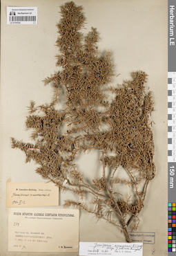
LE 01191534
Juniperus niemannii E.L. Wolf ⟨close to Juniperus sibirica Burgsd.⟩ det. Orlova, Larisa Vladimirovna at 09.07.2022
Additional identifications: Juniperus communis L. det. Ikonnikov-Galitzky, Nikolai Petrovic at 12.09.1940 Collectors: Dolenko, G. I. Field collecting number: 298. Collection date: 28.06.1914. Administrative regions: RU - Respublika Sakha (Yakutiya) - Suntarskiy District. Subregion: Сунтарский улус. Place of collection: 2,4 км северо-западнее пос. Сунтар.Groups of specimens: Образцы сектора Сибири и Дальнего Востока России; Соглашение Минобрнауки №075-15-2021-1056; Из гербария Переселенческого управленияOriginal label text:Museum Botanicum Academiae Scientiarum Petropolitanae. Из гербария Переселенческого Управления. 298. Якутская обл. Вилюйский окр. Елово-лиственничный лес. 2 вер. к с з от Сунтар. 1914.VI 28. Г.И. Доленко
Coordinates (geographic position): 62° 10′ 35.05″ N, 117° 36′ 14.38″ E ±2000 mRecord creation: 2022-07-09, Larisa Orlova, PhotoScan D2. Part 1.Citation: Specimen LE 01191534 // Virtual herbarium of Komarov Botanical Institute RAS — http://re.herbariumle.ru/01191534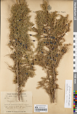
LE 01191535
Juniperus sibirica Burgsd. det. Orlova, Larisa Vladimirovna at 09.07.2022
Additional identifications: Juniperus communis L. det. Unknown Collectors: Drobow, Vasilii Petrovich Field collecting number: 474. Collection date: 01.1914. Administrative regions: RU - Respublika Sakha (Yakutiya). Subregion: Мирнинский улус. Place of collection: р. Чона, в 32 км ниже устья ее правого притока р. Окунайка, березняк в долине реки.Expedition: В.П. Дробов. Киренско-Вилюйская экспедиция 1914 г. ()Groups of specimens: Образцы сектора Сибири и Дальнего Востока России; Соглашение Минобрнауки №075-15-2021-1056; Гербарий Переселенческого УправленияOriginal label text:Гербарий Переселенческого Управления. В.П. Дробов. Киренско-Вилюйская экспедиция 1914 г. 26. № 474. Juniperus communis L. Якутская обл., Вилюйский окр., Р. Чона. в 30 вер-т ниже устья ее прав. прит. р. Окунайки. Березняк в долине реки. W. Drobow. Iter Jakutense, ad fl. Czonam. 1914
Landscape in location of collection: долина рекиHabitat / plant community in location of collecting: березнякCoordinates (geographic position): 62° 6′ 32.4″ N, 110° 6′ 7.92″ E ±110000 mRecord creation: 2022-07-09, Larisa Orlova, PhotoScan D2. Part 1.Citation: Specimen LE 01191535 // Virtual herbarium of Komarov Botanical Institute RAS — http://re.herbariumle.ru/01191535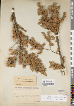
LE 01191536
Juniperus sibirica Burgsd. det. Orlova, Larisa Vladimirovna at 09.07.2022
Additional identifications: Juniperus communis L. det. Ikonnikov-Galitzky, Nikolai Petrovic at 12.09.1940 Collectors: Abolin, Robert Ivanovich Field collecting number: 435. Collection date: 25.06.1912. Administrative regions: RU - Respublika Sakha (Yakutiya). Subregion: Горный улус. Place of collection: верхняя часть бассейна р. Ситте, р. Бадараннах (Бадаранах).Expedition: Р.И. Аболин. Якутско-Вилюйская экспедиция Якутской области (1912)Groups of specimens: Образцы сектора Сибири и Дальнего Востока России; Соглашение Минобрнауки №075-15-2021-1056; Из гербария Переселенческого управленияOriginal label text:Museum Botanicum Academiae Scientiarum Petropolitanae. Из гербария Переселенческого Управления. Якутско-Вилюйская экспедиция. 435. Якутская обл. и округ. Верхняя часть басс. р. Ситтэ, р. Бадаронох. Лиственничный лес на сухой почве. 1912.VI.25. Р,И. Аболин
Habitat / plant community in location of collecting: лиственничный лесSubstrate in collecting location: сухая почваCoordinates (geographic position): 62° 18′ 13.84″ N, 127° 12′ 11.02″ E ±20000 mRecord creation: 2022-07-09, Larisa Orlova, PhotoScan D2. Part 1.Citation: Specimen LE 01191536 // Virtual herbarium of Komarov Botanical Institute RAS — http://re.herbariumle.ru/01191536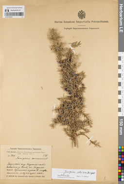
LE 01191537
Juniperus sibirica Burgsd. det. Orlova, Larisa Vladimirovna at 09.07.2022
Additional identifications: Juniperus communis L. det. Abolin, Robert Ivanovich at 1912 Collectors: Abolin, Robert Ivanovich Field collecting number: 924. Collection date: 01.07.1912. Administrative regions: RU - Respublika Sakha (Yakutiya). Subregion: Горный улус. Place of collection: верхняя часть бассейна р. Синяя (Синя), ст. Бырылахская, единичные кусты в лиственничном лесу на сухой почве.Expedition: Р.И. Аболин. Якутско-Вилюйская экспедиция Якутской области (1912)Groups of specimens: Образцы сектора Сибири и Дальнего Востока России; Соглашение Минобрнауки №075-15-2021-1056; Гербарий Переселенческого УправленияOriginal label text:Гербарий Переселенческого Управления. Р.И. Аболин. Якутско-Вилюйская экспедиция Якутской области 1912 г. № 924. 1/VII. juniperus communis L. Якутский окр. Верхняя часть бассейна р. Синя, ст. Бырылахская. Единичные кусты в лиственничном лесу на сухой почве. R. Abolin. Iter Jakutense inter Jakutsk et Vilujsk. 1912
Habitat / plant community in location of collecting: единичные кусты в лиственничном лесуSubstrate in collecting location: сухая почваCoordinates (geographic position): 62° 30′ 8.41″ N, 125° 36′ 30.11″ E ±10000 mRecord creation: 2022-07-09, Larisa Orlova, PhotoScan D2. Part 1.Citation: Specimen LE 01191537 // Virtual herbarium of Komarov Botanical Institute RAS — http://re.herbariumle.ru/01191537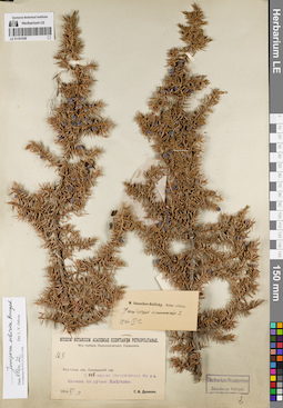
LE 01191538
Juniperus sibirica Burgsd. det. Orlova, Larisa Vladimirovna at 09.07.2022
Additional identifications: Juniperus communis L. det. Ikonnikov-Galitzky, Nikolai Petrovic at 12.09.1940 Collectors: Dolenko, G. I. Field collecting number: 163. Collection date: 13.06.1914. Administrative regions: RU - Respublika Sakha (Yakutiya) - Aldanskiy Rayon. Subregion: Алданский улус. Place of collection: 122 км северо-западнее г. Олекминск, ельник по руч. Хойголах (Хайгалах).Groups of specimens: Образцы сектора Сибири и Дальнего Востока России; Соглашение Минобрнауки №075-15-2021-1056; Из гербария Переселенческого управленияOriginal label text:Museum Botanicum Academiae Scientiarum Petropolitanae. Из гербария Переселенческого Управления. 163. Якутская обл. Олекминский окр. В 115 вер. от Олекминска на с з. Ельник по ручью Хайгалах. 1914.VI,13. Г.И. Доленко
Landscape in location of collection: берег ручьяHabitat / plant community in location of collecting: ельникCoordinates (geographic position): 58° 54′ 44.64″ N, 125° 51′ 23.76″ E ±1000 mRecord creation: 2022-07-09, Larisa Orlova, PhotoScan D2. Part 1.Citation: Specimen LE 01191538 // Virtual herbarium of Komarov Botanical Institute RAS — http://re.herbariumle.ru/01191538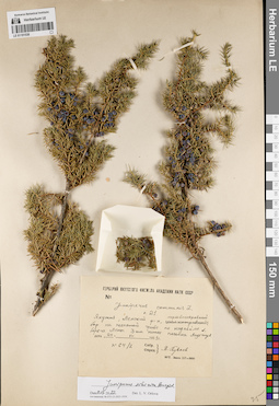
LE 01191539
Juniperus sibirica Burgsd. det. Orlova, Larisa Vladimirovna at 09.07.2022
Additional identifications: Juniperus communis L. det. Kuvaev, Vladimir Borisovich at 1953 Collectors: Kuvaev, Vladimir Borisovich Field collecting number: 64/2. Collection date: 24.07.1953. Administrative regions: RU - Respublika Sakha (Yakutiya) - Lenskiy Rayon. Subregion: Ленский улус. Place of collection: мертвопокровный бор на песчаной гриве по надпойме левого берега р. Лена 3 км ниже г. Ленск (микрорайон Мухтуй).Groups of specimens: Образцы сектора Сибири и Дальнего Востока России; Соглашение Минобрнауки №075-15-2021-1056; Гербарий Якутского филиала Академии Наук СССРOriginal label text:Гербарий Якутского филиала Академии наук СССР. Juniperus communis L. о. 21. Якутия, Ленский р-н, мертвопокровный бор на песчаной гриве по надпойме л. берега Лены 3 км ниже поселка Мухтуя. дата 24 VII 1953 г. no. 64/2. Собр. Опред. В. Куваев
Habitat / plant community in location of collecting: мертвопокровный борSubstrate in collecting location: песокCoordinates (geographic position): 60° 41′ 21.72″ N, 114° 49′ 39.14″ E ±5000 mRecord creation: 2022-07-09, Larisa Orlova, PhotoScan D2. Part 1.Citation: Specimen LE 01191539 // Virtual herbarium of Komarov Botanical Institute RAS — http://re.herbariumle.ru/01191539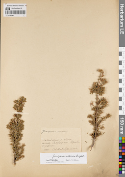
LE 01191542
Juniperus sibirica Burgsd. det. Orlova, Larisa Vladimirovna at 09.07.2022
Additional identifications: Juniperus communis L. det. Gerasimova, K.M. at 1901 Collectors: Gerasimova, K.M. Collection date: 1901. Administrative regions: RU - Irkutskaya Oblast' - Kirenskiy Rayon. Place of collection: левый берег р. Лена, между дер. Заборье и дер. Кривая Лука.Groups of specimens: Образцы сектора Сибири и Дальнего Востока России; Соглашение Минобрнауки №075-15-2021-1056Original label text:Juniperus communis. Левый берег р. Лены, между Заборьем и Кривалуцким. 1901 г. Соб. К.М. Герасимова
Landscape in location of collection: берег крупной рекиCoordinates (geographic position): 57° 35′ 59.14″ N, 107° 50′ 33.82″ E ±500 mRecord creation: 2022-07-09, Larisa Orlova, PhotoScan D2. Part 1.Citation: Specimen LE 01191542 // Virtual herbarium of Komarov Botanical Institute RAS — http://re.herbariumle.ru/01191542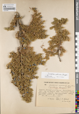
LE 01191544
Juniperus sibirica Burgsd. det. Orlova, Larisa Vladimirovna at 09.07.2022
Additional identifications: Juniperus communis var. sibirica Rydb. det. Kuvaev, Vladimir Borisovich at 1953; Juniperus sibirica Burgsd. det. Kuvaev, Vladimir Borisovich at 1953 Collectors: Kuvaev, Vladimir Borisovich Field collecting number: 42/29. Collection date: 16.07.1953. Administrative regions: RU - Respublika Sakha (Yakutiya) - Lenskiy Rayon. Subregion: Ленский улус. Place of collection: северные склоны Патомского нагорья над правым берегом р. Лена напротив г. Ленск (микрорайон Мухтуй), фрагменты осоково-кустарничковой лесотундры среди тайги на северном склоне.Groups of specimens: Образцы сектора Сибири и Дальнего Востока России; Соглашение Минобрнауки №075-15-2021-1056; Гербарий Якутского филиала Академии Наук СССРOriginal label text:Гербарий Якутского филиала Академии наук СССР. Juniperus communis var. sibirica Rydb. (= J. sibirica Burgsd.) 0.12. Якутия, Ленский р-н, с. склоны Патомского нагорья над пр. берегом Лены напротив Мухтуя, фрагменты осоково-кустарничковой лесотундры среди тайги на с. склоне. дата 16 VII 1953 г. no. 42/29. Собр. Опред. В. Куваев
Landscape in location of collection: северный склон нагорьяHabitat / plant community in location of collecting: фрагменты осоково-кустарничковой лесотундры среди тайгиCoordinates (geographic position): 60° 41′ 21.98″ N, 114° 54′ 32.16″ E ±2000 mRecord creation: 2022-07-09, Larisa Orlova, PhotoScan D2. Part 1.Citation: Specimen LE 01191544 // Virtual herbarium of Komarov Botanical Institute RAS — http://re.herbariumle.ru/01191544
LE 01191546
Juniperus communis L. det. Czekanowski, Alexander Lavrentievich at 1875
Collectors: Czekanowski, Alexander Lavrentievich Collection date: 28.06.1875. Administrative regions: RU - Irkutskaya Oblast' - Kachugskiy Rayon; RU - Respublika Sakha (Yakutiya). Place of collection: в низовьях р. Лена, по р. Нашим.Groups of specimens: Образцы сектора Сибири и Дальнего Востока России; Соглашение Минобрнауки №075-15-2021-1056; Museum botan. Acad. Petrop.Original label text:Museum botan. Acad. Petrop. Juniperus communis L. Ad fluv. Lenam inferiorem, ad fl. Naschim. Czekanowski. 1875. 28 Junii
Landscape in location of collection: берег рекиCoordinates (geographic position): 61° 9′ 7.25″ N, 129° 25′ 57.49″ E ±1000000 mRecord creation: 2022-07-09, Larisa Orlova, PhotoScan D2. Part 1.Citation: Specimen LE 01191546 // Virtual herbarium of Komarov Botanical Institute RAS — http://re.herbariumle.ru/01191546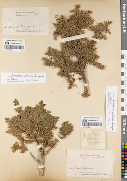
LE 01191547
Juniperus sibirica Burgsd. det. Orlova, Larisa Vladimirovna at 09.07.2022
Additional identifications: Juniperus communis L. det. Czekanowski, Alexander Lavrentievich, Muller von, F. at 1874 Collectors: Czekanowski, Alexander Lavrentievich; Muller von, F. Collection date: 29.06.1874. Administrative regions: RU - Respublika Sakha (Yakutiya) - Olenyoksky District. Subregion: Оленекский улус. Place of collection: по р. Оленёк, возле устья р. Верхняя Томба.Groups of specimens: Образцы сектора Сибири и Дальнего Востока России; Соглашение Минобрнауки №075-15-2021-1056; Museum botan. Acad. Petrop.Original label text:Museum botan. Acad. Petrop. Juniperus communis L. Ad ostium fl. Tomba Superioris. Sibiria orient. ad fl. Olenek legg. A. Czekanowski et F. Müller 1874. 29 Junii
Landscape in location of collection: берег рекиCoordinates (geographic position): 67° 17′ 50.16″ N, 106° 55′ 29.34″ E ±2000 mRecord creation: 2022-07-09, Larisa Orlova, PhotoScan D2. Part 1.Citation: Specimen LE 01191547 // Virtual herbarium of Komarov Botanical Institute RAS — http://re.herbariumle.ru/01191547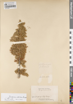
LE 01191548
Juniperus sibirica Burgsd. det. Orlova, Larisa Vladimirovna at 09.07.2022
Additional identifications: Juniperus communis L. det. Czekanowski, Alexander Lavrentievich, Muller von, F. at 1874 Collectors: Czekanowski, Alexander Lavrentievich; Muller von, F. Collection date: 10.08.1874. Administrative regions: RU - Respublika Sakha (Yakutiya) - Olenyoksky District. Subregion: Оленекский улус. Place of collection: Inter fl. Gaiugua et fl. Dalgas.Groups of specimens: Образцы сектора Сибири и Дальнего Востока России; Соглашение Минобрнауки №075-15-2021-1056; Museum botan. Acad. Petrop.Original label text:[1]у р. Оленек на устье р. В. Томбы [2]Ночлег 10 Авг. [3] Museum botan. Acad. Petrop. Juniperus communis L. Inter fl. Gaiugua et fl. Dalgas. Sibiria orient. ad fl. Olenek legg. A. Czekanowski et F. Müller 1874. 10 Aug
Coordinates (geographic position): 68° 39′ 55.14″ N, 115° 0′ 10.34″ E ±15000 mRecord creation: 2022-07-09, Larisa Orlova, PhotoScan D2. Part 1.Citation: Specimen LE 01191548 // Virtual herbarium of Komarov Botanical Institute RAS — http://re.herbariumle.ru/01191548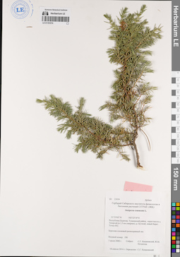
LE 01191574
Juniperus communis L. det. Kazanovsky S. G. at 18.04.2014
Collectors: Pochinchik, Yu.N.; Kazanovsky S. G. Field collecting number: 190 / 33939 Дублет. Collection date: 03.07.2008. Administrative regions: RU - Respublika Buryatiya - Tunkinskiy Rayon. Place of collection: окрестности дер. Тагархай (в 1,5 км севернее), левый берег р. Бугатай, точка 002, березово-сосновый разнотравный лес.Groups of specimens: Образцы сектора Сибири и Дальнего Востока России; Соглашение Минобрнауки №075-15-2021-1056; Гербарий Сибирского института физиологии и биохимии растений СО РАН (IRK)Original label text:ID 33939 Дублет Гербарий Сибирского института физиологии и биохимии растений СО РАН (IRK) Juniperus communis L. 51°53'05'' N 102°22'10'' E Республика Бурятия, Тункинский район, окрестности д. Тагархай (в 1,5 км севернее), р. Бугатай, левый берег. Точка 002. Березово-сосновый разнотравный лес. Полевой номер: 190. 3 июля 2008 г. Собрал: С.Г. Казановский, Ю.Н. Починчик. 18 апреля 2014 г. Определил: С.Г. Казановский
Landscape in location of collection: берег рекиHabitat / plant community in location of collecting: березово-сосновый разнотравный лесCoordinates (geographic position): 51° 53′ 5″ N, 102° 22′ 10″ E ±500 mRecord creation: 2022-07-09, Larisa Orlova, PhotoScan D2. Part 1.Citation: Specimen LE 01191574 // Virtual herbarium of Komarov Botanical Institute RAS — http://re.herbariumle.ru/01191574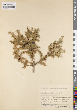
LE 01191575
Juniperus communis L. det. Byalt, Vyacheslav Vyacheslavovich at 1988
Collectors: Byalt, Vyacheslav Vyacheslavovich Collection date: 06.08.1988. Administrative regions: RU - Respublika Buryatiya - Severo-Baykal'skiy Rayon. Place of collection: по дороге на теплый источник Кореней [в тайге по дороге от р. Дзелинда], среди лиственничника, вблизи от дороги.Groups of specimens: Образцы сектора Сибири и Дальнего Востока России; Соглашение Минобрнауки №075-15-2021-1056; Herbarium Universitatis LeninopolitanaeOriginal label text:Herbarium universitatis Leninopolitanae. Juniperus communis L. Бурятия. Северобайкальский р-он. По дороге на теплый ист. Кореней. Среди лиственичника. Вблизи от дороги. 06.08.1988. Leg. Determ. В.В. Бялт
Landscape in location of collection: вблизи от дорогиHabitat / plant community in location of collecting: лиственничникCoordinates (geographic position): 55° 58′ 13.23″ N, 110° 31′ 14.18″ E ±20000 mRecord creation: 2022-07-09, Larisa Orlova, PhotoScan D2. Part 1.Citation: Specimen LE 01191575 // Virtual herbarium of Komarov Botanical Institute RAS — http://re.herbariumle.ru/01191575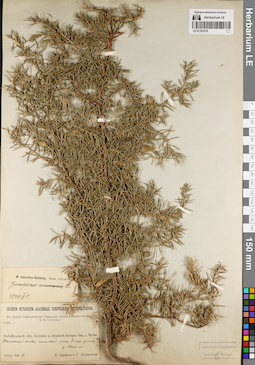
LE 01191576
Juniperus communis L. det. Ikonnikov-Galitzky, Nikolai Petrovic at 12.09.1940
Collectors: Poplavskaya (Poplawska), Henrietta Ippolitovna; Sukaczev, Vladimir Nikolajevich Field collecting number: 1540. Collection date: 19.08.1912. Administrative regions: RU - Respublika Buryatiya - Severo-Baykal'skiy Rayon. Place of collection: бассейн р. Верхней Ангары, окрестности дер. Ченчи, тенистый елово-пихтовый лес близ устья р. Светлая (Акушанда).Expedition: Верхне-Ангарская экспедиция В.Н. Сукачёва (1912)Groups of specimens: Образцы сектора Сибири и Дальнего Востока России; Соглашение Минобрнауки №075-15-2021-1056; Из гербария Переселенческого управленияOriginal label text:Museum Botanicum Academiae Scientiarum Petropolitanae. Из гербария Переселенческого Управления. Верхне-Ангарская экспедиция В.Н. Сукачева. 1540. Забайкальск. обл. Бассейн р. Верхней Ангары. Окр. д. Ченчи. Тенистый елово-пихтовый лес близ устья р. Светлой. 1912.VIII.19. В. Сукачев и Г. Поплавская
Landscape in location of collection: берег рекиHabitat / plant community in location of collecting: тенистый елово-пихтовый лесCoordinates (geographic position): 55° 58′ 0.6″ N, 110° 59′ 47.47″ E ±10000 mRecord creation: 2022-07-09, Larisa Orlova, PhotoScan D2. Part 1.Citation: Specimen LE 01191576 // Virtual herbarium of Komarov Botanical Institute RAS — http://re.herbariumle.ru/01191576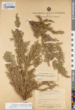
LE 01191577
Juniperus niemannii E.L. Wolf ⟨close to Juniperus sibirica Burgsd.⟩ det. Orlova, Larisa Vladimirovna at 09.07.2022
Additional identifications: Juniperus communis L. det. Ikonnikov-Galitzky, Nikolai Petrovic at 12.09.1940 Collectors: Poplavskaya (Poplawska), Henrietta Ippolitovna; Sukaczev, Vladimir Nikolajevich Field collecting number: 397. Collection date: 29.06.1912. Administrative regions: RU - Respublika Buryatiya - Severo-Baykal'skiy Rayon. Place of collection: бассейн р. Верхней Ангары, окрестности дер. Ченчи, сухой сосняк.Expedition: В.Н. Сукачев. Верхне-Ангарская экспедиция Забайкальской области 1912 г. () (1912)Groups of specimens: Образцы сектора Сибири и Дальнего Востока России; Соглашение Минобрнауки №075-15-2021-1056; Гербарий Переселенческого УправленияOriginal label text:Гербарий Переселенческого Управления. В.Н. Сукачев. Верхне-Ангарская экспедиция Забайкальской области 1912 г. № 397. Бассейн р. Верхней Ангары. Окр. д. Ченчи. Сухой сосняк. 29.VI Собр. В. Сукачев и Г. Поплавская. W. Sukaczew. Iter Transbaicalense ad fl. Angara Superior. 1912
Landscape in location of collection: берег крупной рекиHabitat / plant community in location of collecting: сухой соснякCoordinates (geographic position): 55° 57′ 57.52″ N, 110° 59′ 45.15″ E ±10000 mRecord creation: 2022-07-09, Larisa Orlova, PhotoScan D2. Part 1.Citation: Specimen LE 01191577 // Virtual herbarium of Komarov Botanical Institute RAS — http://re.herbariumle.ru/01191577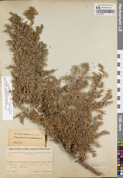
LE 01191578
Juniperus niemannii E.L. Wolf ⟨intermediate forma⟩ det. Orlova, Larisa Vladimirovna at 09.07.2022
Additional identifications: Juniperus communis L. det. Ikonnikov-Galitzky, Nikolai Petrovic at 12.09.1940 Collectors: Poplavskaya (Poplawska), Henrietta Ippolitovna; Sukaczev, Vladimir Nikolajevich Field collecting number: 1539. Collection date: 19.08.1912. Administrative regions: RU - Respublika Buryatiya - Severo-Baykal'skiy Rayon. Place of collection: бассейн р. Верхней Ангары, окрестности дер. Ченчи, тенистый елово-пихтовый лес близ устья р. Светлая (Акушанда).Expedition: Верхне-Ангарская экспедиция В.Н. Сукачёва (1912)Groups of specimens: Образцы сектора Сибири и Дальнего Востока России; Соглашение Минобрнауки №075-15-2021-1056; Гербарий Переселенческого УправленияOriginal label text:Museum Botanicum Academiae Scientiarum Petropolitanae. Из гербария Переселенческого Управления. Верхне-Ангарская экспедиция В.Н. Сукачева. 1540. Забайкальск. обл. Бассейн р. Верхней Ангары. Окр. д. Ченчи. Тенистый елово-пихтовый лес близ устья р. Светлой. 1912.VIII.19. В. Сукачев и Г. Поплавская
Landscape in location of collection: берег рекиHabitat / plant community in location of collecting: тенистый елово-пихтовый лесCoordinates (geographic position): 55° 58′ 0.6″ N, 110° 59′ 47.47″ E ±10000 mRecord creation: 2022-07-09, Larisa Orlova, PhotoScan D2. Part 1.Citation: Specimen LE 01191578 // Virtual herbarium of Komarov Botanical Institute RAS — http://re.herbariumle.ru/01191578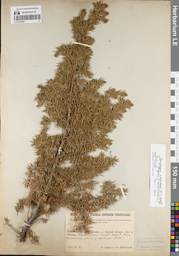
LE 01191581
Juniperus niemannii E.L. Wolf ⟨close to Juniperus communis L.⟩ det. Orlova, Larisa Vladimirovna at 09.07.2022
Collectors: Sukaczev, Vladimir Nikolajevich; Schipczinski, Nikolaj Valerianovich Field collecting number: 308. Collection date: 18.06.1912. Administrative regions: RU - Respublika Buryatiya - Severo-Baykal'skiy Rayon. Place of collection: бассейн р. Верхняя Ангара, окрестности дер. Чечевки, Душкачанский голец, падь Большая Ухта, каменистая осыпь у границы леса.Expedition: Верхне-Ангарская экспедиция В.Н. Сукачёва (1912)Groups of specimens: Образцы сектора Сибири и Дальнего Востока России; Соглашение Минобрнауки №075-15-2021-1056; Из гербария Переселенческого управленияOriginal label text:Museum Botanicum Academiae Scientiarum Petropolitanae. Из гербария Переселенческого Управления. Верхне-Ангарская экспедиция В.Н. Сукачева. 308. Забайкальск. обл. Бассейн р. Верхней Ангары. Окр. д. Чечевок. Душкачанский голец. Падь Б. Ухта. Каменистая осыпь у границы леса. 1912.VI.18. В. Сукачев и Н. Шипчинский
Landscape in location of collection: каменистая осыпь у границы леса в пределах падиHabitat / plant community in location of collecting: у границы лесаCoordinates (geographic position): 55° 47′ 0.33″ N, 109° 36′ 43.3″ E ±20000 mRecord creation: 2022-07-09, Larisa Orlova, PhotoScan D2. Part 1.Citation: Specimen LE 01191581 // Virtual herbarium of Komarov Botanical Institute RAS — http://re.herbariumle.ru/01191581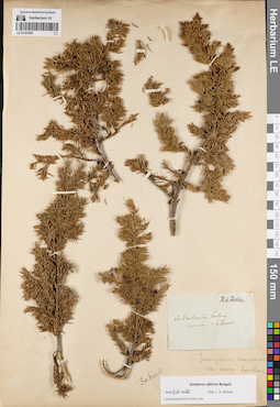
LE 01191587
Juniperus communis var. nana Loud. det. Unknown
Additional identifications: Juniperus sibirica Burgsd. det. Orlova, Larisa Vladimirovna at 09.07.2022 Collectors: Salesov Groups of specimens: Образцы сектора Сибири и Дальнего Востока России; Соглашение Минобрнауки №075-15-2021-1056Record creation: 2022-07-09, Larisa Orlova, PhotoScan D2. Part 1.Citation: Specimen LE 01191587 // Virtual herbarium of Komarov Botanical Institute RAS — http://re.herbariumle.ru/01191587
LE 01191591
Juniperus sibirica Burgsd. det. Orlova, Larisa Vladimirovna at 09.07.2022
Additional identifications: Juniperus communis L. det. Kryukov, Innokentij Fedorovitch at 1905 Collectors: Kryukov, Innokentij Fedorovitch Field collecting number: 1747. Collection date: 08.08.1905. Administrative regions: RU - Respublika Buryatiya - Bauntovskiy Rayon. Place of collection: восточный склон хр. Икатский (Икатские горы).Expedition: И.Ф. Крюков: Флора Баргузинской тайги Забайкальской области (1905)Groups of specimens: Образцы сектора Сибири и Дальнего Востока России; Соглашение Минобрнауки №075-15-2021-1056Original label text:И.Ф. Крюков: Флора Баргузинской тайги Забайкальской области. Juniperus communis. На восточном склоне Икатских гор. 1747. 8 VIII 1905 г.
Landscape in location of collection: склон горного хребтаCoordinates (geographic position): 53° 35′ 57.12″ N, 111° 0′ 0″ E ±20000 mRecord creation: 2022-07-09, Larisa Orlova, PhotoScan D2. Part 1.Citation: Specimen LE 01191591 // Virtual herbarium of Komarov Botanical Institute RAS — http://re.herbariumle.ru/01191591
LE 01191593
Juniperus sibirica Burgsd. det. Orlova, Larisa Vladimirovna at 09.07.2022
Additional identifications: Juniperus communis L. det. Unknown Collectors: Turczaninow, Nicolai Stepanowisch Collection date: 1829. Administrative regions: RU - Respublika Buryatiya. Place of collection: линия р. Селенга, лесистые горы.Groups of specimens: Образцы сектора Сибири и Дальнего Востока России; Соглашение Минобрнауки №075-15-2021-1056; Ex herbario TurczaninowianoOriginal label text:In montibus sylvosis in vicinis de linerum Selinginensium 1829 Turcz
Landscape in location of collection: горный склонHabitat / plant community in location of collecting: горный лесCoordinates (geographic position): 51° 41′ 1.12″ N, 107° 19′ 39.51″ E ±150000 mRecord creation: 2022-07-09, Larisa Orlova, PhotoScan D2. Part 1.Citation: Specimen LE 01191593 // Virtual herbarium of Komarov Botanical Institute RAS — http://re.herbariumle.ru/01191593
LE 01191595
Juniperus sibirica Burgsd. det. Orlova, Larisa Vladimirovna at 09.07.2022
Additional identifications: Juniperus communis L. det. Arndt, P. at 1910 Collectors: Arndt, P. Collection date: 18.06.1910. Administrative regions: RU - Zabaykal'skiy Kray - Khilokskiy Rayon. Place of collection: Право-Хилокская лесная дача, ж.д. ст. Гыршелун (Гыршелун-Тарбагатай).Groups of specimens: Образцы сектора Сибири и Дальнего Востока России; Соглашение Минобрнауки №075-15-2021-1056Original label text:[1]18/VI Т. Тайга. Почва силикат. россып [тогц.] сухая на осыпи. мест. [2]Museum Botanicum Academiae Scientiarum Petropolitanae. Juniperus communis L. Забайкаль. обл. Верхнеуд. у. Право-Хилокская лесная дача. Ст. Гыршелун-Тарбагатай Заб. ж.д. 1910.VI.18. П. Арндт
Habitat / plant community in location of collecting: окружение железнодорожной станцииCoordinates (geographic position): 51° 24′ 27.64″ N, 110° 39′ 35.47″ E ±10000 mRecord creation: 2022-07-09, Larisa Orlova, PhotoScan D2. Part 1.Citation: Specimen LE 01191595 // Virtual herbarium of Komarov Botanical Institute RAS — http://re.herbariumle.ru/01191595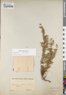
LE 01191596
Juniperus sibirica Burgsd. det. Orlova, Larisa Vladimirovna at 09.07.2022
Additional identifications: Juniperus communis L. det. Unknown Collectors: Arndt, P. Collection date: 08.1910. Administrative regions: RU - Zabaykal'skiy Kray - Khilokskiy Rayon. Place of collection: Вершина г. Цибитуй.Groups of specimens: Образцы сектора Сибири и Дальнего Востока России; Соглашение Минобрнауки №075-15-2021-1056Original label text:Museum Botanicum Academiae Scientiarum Petropolitanae. Juniperus communis L. Забайкаль. обл. Верхнеуд. у. Вершина Цибитуя. 1910.VIII. П. Арндт
Landscape in location of collection: вершина горыCoordinates (geographic position): 51° 8′ 14.64″ N, 110° 21′ 40.31″ E ±500 mRecord creation: 2022-07-09, Larisa Orlova, PhotoScan D2. Part 1.Citation: Specimen LE 01191596 // Virtual herbarium of Komarov Botanical Institute RAS — http://re.herbariumle.ru/01191596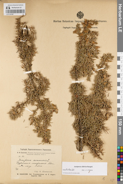
LE 01191597
Juniperus sibirica Burgsd. det. Orlova, Larisa Vladimirovna at 09.07.2022
Additional identifications: Juniperus communis L. det. Schipczinski, Nikolaj Valerianovich at 1912 Collectors: Schipczinski, Nikolaj Valerianovich Field collecting number: 83. Collection date: 02.06.1912. Administrative regions: RU - Respublika Buryatiya - Pribaykal'skiy Rayon. Place of collection: с. Горячинск, Туркинский горячий источник (Туркинские минеральные воды), в лесу.Expedition: В.Н. Сукачев. Верхне-Ангарская экспедиция Забайкальской области 1912 г. () (1912)Groups of specimens: Образцы сектора Сибири и Дальнего Востока России; Соглашение Минобрнауки №075-15-2021-1056; Гербарий Переселенческого УправленияObject features: редкоOriginal label text:Гербарий Переселенческого Управления. В.Н. Сукачев. Верхне-Ангарская экспедиция Забайкальской области 1912 г. № 83. Juniperus communis L. Туркинские минеральные воды. В лесу. Редко. 2/VI. Собр. Н. Шипчинский. W. Sukaczew. Iter Transbaicalense ad fl. Angara Superior. 1912
Landscape in location of collection: горячий источникHabitat / plant community in location of collecting: лесCoordinates (geographic position): 52° 59′ 14.24″ N, 108° 18′ 29.09″ E ±1000 mRecord creation: 2022-07-09, Larisa Orlova, PhotoScan D2. Part 1.Citation: Specimen LE 01191597 // Virtual herbarium of Komarov Botanical Institute RAS — http://re.herbariumle.ru/01191597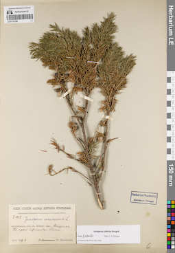
LE 01191598
Juniperus sibirica Burgsd. det. Orlova, Larisa Vladimirovna at 09.07.2022
Additional identifications: Juniperus communis L. det. Unknown Collectors: Zinserling (Tsinzerling), Iurij (Yuri, Georgius) Dmitrievitch Field collecting number: 3102. Collection date: 06.08.1915. Administrative regions: RU - Respublika Buryatiya - Kabanskiy Rayon. Place of collection: ж.д. ст. Мишиха, край сфагнового болота.Expedition: Байкальская экспедиция Императорской Академии Наук (1915)Groups of specimens: Образцы сектора Сибири и Дальнего Востока России; Соглашение Минобрнауки №075-15-2021-1056Original label text:Museum Botanicum Academiae Scientiarum Petropolitanae. Байкальская экспедиция Императорской Академии Наук. 3102. Juniperus communis L. Забайкальск. обл. Оз. Байкал. ст. Мишиха. По краю сфагнового болота. 1915.VIII.6. Ю. Цинзерлинг
Habitat / plant community in location of collecting: край сфагнового болотаCoordinates (geographic position): 51° 39′ 9.47″ N, 105° 35′ 23.46″ E ±10000 mRecord creation: 2022-07-09, Larisa Orlova, PhotoScan D2. Part 1.Citation: Specimen LE 01191598 // Virtual herbarium of Komarov Botanical Institute RAS — http://re.herbariumle.ru/01191598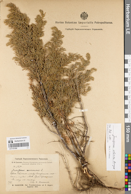
LE 01191599
Juniperus sibirica Burgsd. det. Orlova, Larisa Vladimirovna at 09.07.2022
Additional identifications: Juniperus communis L. det. Schipczinski, Nikolaj Valerianovich at 1912 Collectors: Schipczinski, Nikolaj Valerianovich Field collecting number: 525. Collection date: 06.08.1912. Administrative regions: RU - Respublika Buryatiya - Severo-Baykal'skiy Rayon. Place of collection: берег оз. Байкал между Дагарским маяком и губой Аяя, руч. Эрекшакан (Ираксокал), лес по склону.Expedition: В.Н. Сукачев. Верхне-Ангарская экспедиция Забайкальской области 1912 г. () (1912)Groups of specimens: Образцы сектора Сибири и Дальнего Востока России; Соглашение Минобрнауки №075-15-2021-1056; Гербарий Переселенческого УправленияOriginal label text:Гербарий Переселенческого Управления. В.Н. Сукачев. Верхне-Ангарская экспедиция Забайкальской области 1912 г. № 525. Juniperus communis L. Берег Байкала между Дагарским маяком и губой Аяя. Ручей Ираксокал. В лесу по склону. 6/VIII. Собр. Н. Шипчинский. W. Sukaczew. Iter Transbaicalense ad fl. Angara Superior. 1912
Landscape in location of collection: склон по берегу ручьяHabitat / plant community in location of collecting: лес по склонуCoordinates (geographic position): 55° 34′ 21.1″ N, 109° 54′ 13.9″ E ±5000 mRecord creation: 2022-07-09, Larisa Orlova, PhotoScan D2. Part 1.Citation: Specimen LE 01191599 // Virtual herbarium of Komarov Botanical Institute RAS — http://re.herbariumle.ru/01191599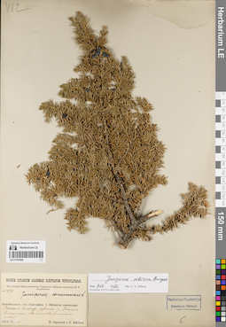
LE 01191600
Juniperus sibirica Burgsd. det. Orlova, Larisa Vladimirovna at 09.07.2022
Additional identifications: Juniperus communis L. det. Unknown Collectors: Lebedeva, Z.; Korotky, Mikhail Fedorovich Field collecting number: 482. Collection date: 12.07.1914. Administrative regions: RU - Zabaykal'skiy Kray - Tungokochenskiy Rayon. Place of collection: Витимское плоскогорье, перевал в обход россыпей р. Ишанда (Ижинда), лиственничный лес.Expedition: Муйская экспедиция М.Ф. Короткого (1914)Groups of specimens: Образцы сектора Сибири и Дальнего Востока России; Соглашение Минобрнауки №075-15-2021-1056; Из гербария Переселенческого управленияOriginal label text:Museum Botanicum Academiae Scientiarum Petropolitanae. Из гербария Переселенческого Управления. Муйская экспедиция М.Ф. Короткого. N 482. Juniperus communis L. Забайкальск. обл. Баргузинск. у. Витимское плоскогорье. Перевал в обход россыпей р. Ижинде. Циплинкоw. В лиственничном лесу. 1914.VII-12. М. Короткий и З. Лебедева
Landscape in location of collection: горный перевал в обход россыпей рекиHabitat / plant community in location of collecting: лиственничный лесCoordinates (geographic position): 53° 27′ 57.78″ N, 114° 48′ 40.96″ E ±2000 mRecord creation: 2022-07-09, Larisa Orlova, PhotoScan D2. Part 1.Citation: Specimen LE 01191600 // Virtual herbarium of Komarov Botanical Institute RAS — http://re.herbariumle.ru/01191600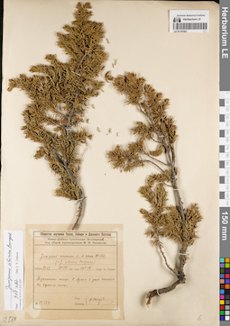
LE 01191601
Juniperus sibirica Burgsd. det. Orlova, Larisa Vladimirovna at 09.07.2022
Additional identifications: Juniperus communis var. nana Willd. det. Nasarow, Mikhail Ivanovich at 1929; Juniperus sibirica Burgsd. det. Nasarow, Mikhail Ivanovich at 1929 Collectors: Nasarow, Mikhail Ivanovich Field collecting number: 12.564. Collection date: 27.07.1929. Administrative regions: RU - Respublika Buryatiya - Tunkinskiy Rayon. Place of collection: Тункинские гольцы, р. Иркут (Архыт) в устье р. Хонголдой, вершина гольца.Expedition: Хамар-Дабано-Тункинская экспедиция под общим руководством М.И. Назарова (1929)Groups of specimens: Образцы сектора Сибири и Дальнего Востока России; Соглашение Минобрнауки №075-15-2021-1056; Общество изучения Урала, Сибири и Дальнего ВостокаOriginal label text:Общество изучения Урала, Сибири и Дальнего Востока. Хамар-Дабано-Тункинская Экспедиция под общим руководством М.И. Назарова. Juniperus communis L. v. nana Willd. (=J. sibirica Burgsdorf) 1929.VII.27. 51°, 54' lat. bor. 101°, 48' long. or. Grinw. Тункинские гольцы. Р. Архыт в устье Хонхолоя. На вершине гольца. № 12.564. Leg. Determ. М. Назаров
Landscape in location of collection: вершина гольцаCoordinates (geographic position): 51° 42′ 26.04″ N, 101° 39′ 34.11″ E ±5000 mRecord creation: 2022-07-09, Larisa Orlova, PhotoScan D2. Part 1.Citation: Specimen LE 01191601 // Virtual herbarium of Komarov Botanical Institute RAS — http://re.herbariumle.ru/01191601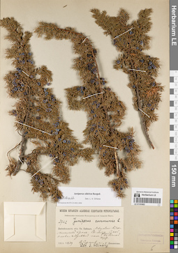
LE 01191602
Juniperus sibirica Burgsd. det. Orlova, Larisa Vladimirovna at 09.07.2022
Additional identifications: Juniperus communis L. det. Steinberg, Elisabeth Ivanovna Collectors: Poplavskaya (Poplawska), Henrietta Ippolitovna; Sukaczev, Vladimir Nikolajevich Field collecting number: 2762. Collection date: 29.07.1915. Administrative regions: RU - Respublika Buryatiya - Kabanskiy Rayon. Place of collection: Мысовск-Кяхтинский тракт, ст. Улятыйская (Уляты) [в 1 версте от высочайшей вершины хр. Хамар-Дабан, в 60 верстах от с. Темник на север, недалеко от долины р. Мысовка], сухой елово-кедровый лес.Expedition: Байкальская экспедиция Императорской Академии Наук (1915)Groups of specimens: Образцы сектора Сибири и Дальнего Востока России; Соглашение Минобрнауки №075-15-2021-1056Object features: Большой кустOriginal label text:Museum Botanicum Academiae Scientiarum Petropolitanae. Байкальская экспедиция Императорской Академии Наук. 2762. Juniperus communis L. Забайкальск. обл. Оз. Байкал. Мысовск-Кяхтинский тракт. Ст. Уляты. Сухой елово-кедровый лес. Большой куст. 1915.VII.29. В. Сукачев и Г. Поплавская. Det. E. Steinberg
Landscape in location of collection: склон горного хребтаHabitat / plant community in location of collecting: сухой елово-кедровый лесCoordinates (geographic position): 51° 29′ 42.95″ N, 105° 58′ 39.22″ E ±10000 mRecord creation: 2022-07-09, Larisa Orlova, PhotoScan D2. Part 1.Citation: Specimen LE 01191602 // Virtual herbarium of Komarov Botanical Institute RAS — http://re.herbariumle.ru/01191602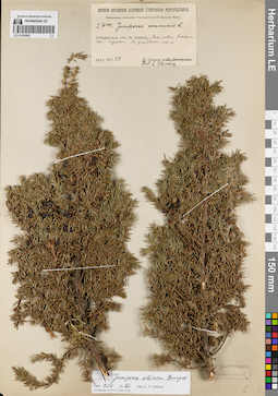
LE 01191603
Juniperus sibirica Burgsd. det. Orlova, Larisa Vladimirovna at 09.07.2022
Additional identifications: Juniperus communis L. det. Steinberg, Elisabeth Ivanovna at 1915 Collectors: Sukaczev, Vladimir Nikolajevich Field collecting number: 2700. Collection date: 28.07.1915. Administrative regions: RU - Respublika Buryatiya - Selenginskiy Rayon. Place of collection: оз. Байкал, Мысовск-Кяхтинский тракт, редкий лес.Expedition: Байкальская экспедиция Императорской Академии Наук (1915)Groups of specimens: Образцы сектора Сибири и Дальнего Востока России; Соглашение Минобрнауки №075-15-2021-1056Original label text:Museum Botanicum Academiae Scientiarum Petropolitanae. Байкальская экспедиция императорской Академии Наук. 2700. Juniperus communis L. Забайкальск. обл. Оз. Байкал. Мысовск-Кяхтинский тракт. В редком лесу. 1915.VII.28. В. Сукачев. Det. E. Steinberg
Habitat / plant community in location of collecting: редкий лесCoordinates (geographic position): 51° 4′ 28.79″ N, 106° 6′ 48.08″ E ±75000 mRecord creation: 2022-07-09, Larisa Orlova, PhotoScan D2. Part 1.Citation: Specimen LE 01191603 // Virtual herbarium of Komarov Botanical Institute RAS — http://re.herbariumle.ru/01191603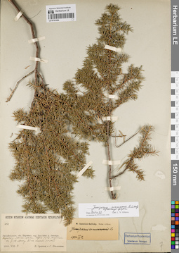
LE 01191604
Juniperus niemannii E.L. Wolf ⟨intermediate forma⟩ det. Orlova, Larisa Vladimirovna at 09.07.2022
Additional identifications: Juniperus communis L. det. Ikonnikov-Galitzky, Nikolai Petrovic at 12.09.1940 Collectors: Poplavskaya (Poplawska), Henrietta Ippolitovna; Sukaczev, Vladimir Nikolajevich Field collecting number: 1033. Collection date: 04.08.1910. Administrative regions: RU - Zabaykal'skiy Kray - Mogochinskiy Rayon. Place of collection: бассейн р. Амазар, верховья р. Малая Могоча, вдоль ручья, впадающего в р. Малая Могоча, 23-ая стоянка.Groups of specimens: Образцы сектора Сибири и Дальнего Востока России; Соглашение Минобрнауки №075-15-2021-1056Original label text:Museum Botanicum Academiae Scientiarum Petropolitanae. 1033. Забайкальск. обл. Нерчинск. окр. Бассейн р. Амазара. Верховья р. Малой Магочи. Вдоль ручья, впадающего в р. М. Магочу. 23-ая стоянка. (N=1567) 1910.VIII.4. В. Сукачев и Г. Поплавская
Landscape in location of collection: берег ручьяCoordinates (geographic position): 54° 6′ 45.84″ N, 120° 11′ 21.33″ E ±10000 mRecord creation: 2022-07-09, Larisa Orlova, PhotoScan D2. Part 1.Citation: Specimen LE 01191604 // Virtual herbarium of Komarov Botanical Institute RAS — http://re.herbariumle.ru/01191604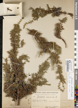
LE 01191605
Juniperus sibirica Burgsd. det. Orlova, Larisa Vladimirovna at 09.07.2022
Additional identifications: Juniperus communis L. det. Steinberg, Elisabeth Ivanovna at 1915 Collectors: Poplavskaya (Poplawska), Henrietta Ippolitovna; Sukaczev, Vladimir Nikolajevich Field collecting number: 2602. Collection date: 26.07.1915. Administrative regions: RU - Irkutskaya Oblast'; RU - Respublika Buryatiya. Place of collection: оз. Байкал, берег оз. Байкал близ устья р. Северная.Expedition: Байкальская экспедиция Императорской Академии Наук (1915)Groups of specimens: Образцы сектора Сибири и Дальнего Востока России; Соглашение Минобрнауки №075-15-2021-1056Original label text:Museum Botanicum Academiae Scientiarum Petropolitanae. Байкальская экспедиция императорской Академии Наук. 2602. Juniperus communis L. Забайкальск. обл. Оз. Байкал. Берег Байкала близ устья р. Северной. 1915.VII.26. В. Сукачев и Г. Поплавская. Det. E. Steinberg
Landscape in location of collection: берег крупного озераCoordinates (geographic position): 53° 24′ 19.2″ N, 107° 40′ 23.01″ E ±320000 mRecord creation: 2022-07-09, Larisa Orlova, PhotoScan D2. Part 1.Citation: Specimen LE 01191605 // Virtual herbarium of Komarov Botanical Institute RAS — http://re.herbariumle.ru/01191605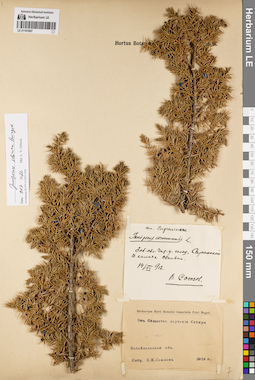
LE 01191607
Juniperus sibirica Burgsd. det. Orlova, Larisa Vladimirovna at 09.07.2022
Additional identifications: Juniperus communis L. det. Soyuzov, V.I. at 1912 Collectors: Soyuzov, V.I. Collection date: 14.06.1912. Administrative regions: RU - Zabaykal'skiy Kray - Chitinskiy Rayon. Place of collection: голец Саранакан, в камнях.Groups of specimens: Образцы сектора Сибири и Дальнего Востока России; Соглашение Минобрнауки №075-15-2021-1056; От Общества изучения СибириObject features: ОбильноOriginal label text:[1]сем. Cupressineae. Juniperus communis L. Заб. обл. Чит. у. голец "Саранакан". В камнях. Обильно. 14/VI 912. В. Союзов [2] Herbarium Horti Botanici Imperialis Petri Magni. От Общества изучения Сибири. Забайкальская обл. Собр. В.И. Союзов. 1912 г.
Landscape in location of collection: камни на склоне гольцаCoordinates (geographic position): 52° 34′ 45.34″ N, 113° 47′ 13.54″ E ±5000 mRecord creation: 2022-07-09, Larisa Orlova, PhotoScan D2. Part 1.Citation: Specimen LE 01191607 // Virtual herbarium of Komarov Botanical Institute RAS — http://re.herbariumle.ru/01191607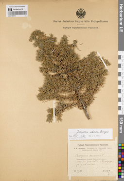
LE 01191610
Juniperus sibirica Burgsd. det. Orlova, Larisa Vladimirovna at 09.07.2022
Additional identifications: Juniperus communis L. det. Kusnezow, Nicolai Ivanovitch at 1909 Collectors: Kusnezow, Nicolai Ivanovitch Field collecting number: 1059. Collection date: 10.07.1909. Administrative regions: RU - Zabaykal'skiy Kray - Nerchinsko-Zavodskiy Rayon. Place of collection: лес на дне пади Мургулунда у ее истока.Expedition: Н.И. Кузнецов. Экспедиция в Нерчинский округ Забайкальской области. 1909 г. (1909)Groups of specimens: Образцы сектора Сибири и Дальнего Востока России; Соглашение Минобрнауки №075-15-2021-1056; Гербарий Переселенческого УправленияOriginal label text:Гербарий Переселенческого Управления. Н.И. Кузнецов. Экспедиция в Нерчинский округ Забайкальской области. 1909 г. Juniperus communis L. Забайкальская область, Нерчинский округ. Лес на дне пади Мургулунда у ее истока. 10.VII.1909. № 1059
Landscape in location of collection: дно падиHabitat / plant community in location of collecting: лесCoordinates (geographic position): 51° 20′ 59.24″ N, 119° 28′ 42.57″ E ±130000 mRecord creation: 2022-07-09, Larisa Orlova, PhotoScan D2. Part 1.Citation: Specimen LE 01191610 // Virtual herbarium of Komarov Botanical Institute RAS — http://re.herbariumle.ru/01191610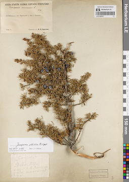
LE 01191611
Juniperus sibirica Burgsd. det. Orlova, Larisa Vladimirovna at 09.07.2022
Additional identifications: Juniperus communis L. det. Steinberg, Elisabeth Ivanovna Collectors: Sukaczev, Vladimir Nikolajevich Collection date: 05.1909. Administrative regions: RU - Zabaykal'skiy Kray - Sretenskiy Rayon. Place of collection: окрестности с. Шеметово (Бянкино).Groups of specimens: Образцы сектора Сибири и Дальнего Востока России; Соглашение Минобрнауки №075-15-2021-1056Original label text:[1]Museum Botanicum Academiae Scientiarum Petropolitanae. Juniperus communis L. Е.Ш[тейнберг]. Забайкальск. обл. Нерчинский у. Окр. с. Бянкина. 1909.V. Получено от В.Н. Сукачева [2] "Багул" 28 Ап. 1909 г. близ с. Бянкино, заб. об. на склоне горы
Coordinates (geographic position): 51° 59′ 57.49″ N, 116° 56′ 34.89″ E ±5000 mRecord creation: 2022-07-09, Larisa Orlova, PhotoScan D2. Part 1.Citation: Specimen LE 01191611 // Virtual herbarium of Komarov Botanical Institute RAS — http://re.herbariumle.ru/01191611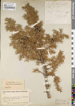
LE 01191612
Juniperus communis L. det. Poplavskaya (Poplawska), Henrietta Ippolitovna, Blagoveshchensky, N.V. at 1909
Additional identifications: Juniperus communis L. det. Ikonnikov-Galitzky, Nikolai Petrovic at 12.09.1940 Collectors: Poplavskaya (Poplawska), Henrietta Ippolitovna; Blagoveshchensky, N.V. Field collecting number: 1083. Collection date: 10.07.1909. Administrative regions: RU - Zabaykal'skiy Kray. Place of collection: водораздел между р. Шилка и Черный Урюм, падь р. Маргорунда.Groups of specimens: Образцы сектора Сибири и Дальнего Востока России; Соглашение Минобрнауки №075-15-2021-1056Original label text:[1]Juniperus communis стелющаяся падь Маргорунда 10/VIII 09 Шилкинская экспедиция [2] Museum Botanicum Academiae Scientiarum Petropolitanae. 1083. Забайкальск. обл. Нерчинско-Завод. окр. Водораздел между рр. Шилкой и Черным Урюмом. Падь р. Маргорунды. 1909.VII.10. Собр. Н.В. Благовещенский и Г.И. Поплавская
Landscape in location of collection: падьCoordinates (geographic position): 52° 57′ 37.53″ N, 118° 30′ 55.8″ E ±240000 mRecord creation: 2022-07-09, Larisa Orlova, PhotoScan D2. Part 1.Citation: Specimen LE 01191612 // Virtual herbarium of Komarov Botanical Institute RAS — http://re.herbariumle.ru/01191612