View
Add
Copy
Edit
Delete
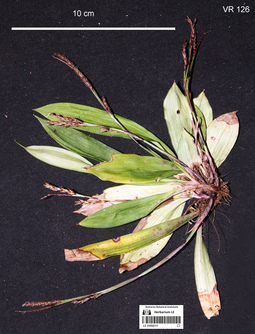
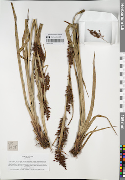
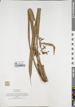
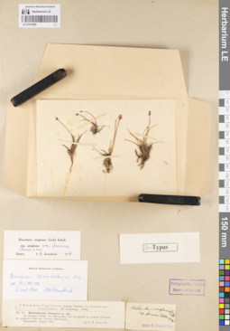
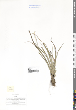
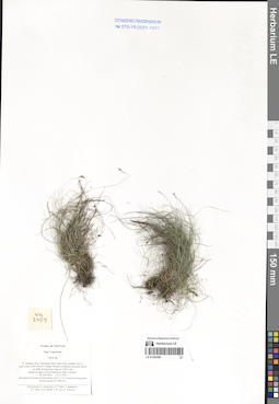
LE 01058111
Carex oblanceolata T.Koyama det. Averyanov, Leonid Vladimirovich at 14.04.2018
Collectors: Averyanov, Leonid Vladimirovich; Khang Sinh Nguyen; Chuong Quang Ngan; Maisak, Tatiana Viktorovna Field collecting number: VR126. Collection date: 14.04.2018. Administrative regions: VN - Tinh Ha Giang. Groups of specimens: L. V. Averyanov specimens; L. V. Averyanov herbarium; L. V. Averyanov photosOriginal label text:FLORA OF VIETNAM Cyperaceae Carex oblanceolata T. Koyama ( = Carex trongii K.K. Nguyen) Ha Giang prov., Quan Ba distr., Bat Dai Son Nature Reserve, Can Ty commune, Dau Cau 1 village, around point 23º05ʹ26.3ʺN 105º01ʹ03.0ʺE, 1100-1150 m a.s.l., karstic, highly eroded mountains composed of solid marble-like limestone, primary evergreen broad-leaved humid forest on steep rocky slopes near mountain tops. Clustering sedge on vertical shady cliff. Occasional. 14 April 2018, L. Averyanov, Nguyen Sinh Khang, Chuong Quang Ngan, T. Maisak, VR 126.
Comment: All photos © L. Averyanov & K.S. Nguyen
Record creation: 2019-06-20, Аверьянов Леонид ВладимировичCitation: Specimen LE 01058111 // Virtual herbarium of Komarov Botanical Institute RAS — http://re.herbariumle.ru/01058111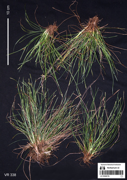
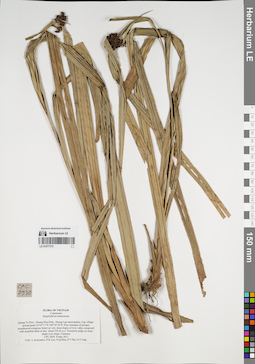
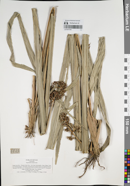
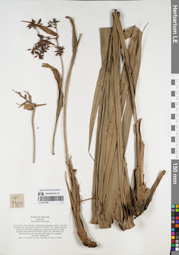
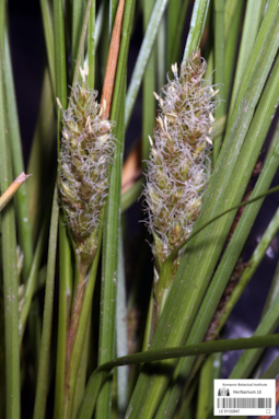
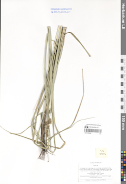
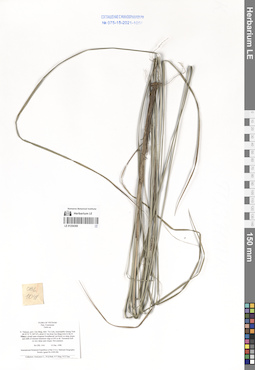
LE 01058176
Carex tsaiana P.C.Li det. Averyanov, Leonid Vladimirovich at 18.04.2018
Collectors: Averyanov, Leonid Vladimirovich; Khang Sinh Nguyen; Chuong Quang Ngan; Maisak, Tatiana Viktorovna Field collecting number: VR338. Collection date: 18.04.2018. Administrative regions: VN - Tinh Ha Giang. Groups of specimens: L. V. Averyanov specimens; L. V. Averyanov photos; L. V. Averyanov herbariumOriginal label text:FLORA OF VIETNAM Cyperaceae Carex tsaiana P.C. Li Ha Giang prov., Quan Ba distr., Bat Dai Son Nature Reserve, Thanh Van commune, Mo Sai village, around point 23º07ʹ46.4ʺN 104º57ʹ56.2ʺE, at elevation 1000-1190 m a.s.l., karstic, highly eroded mountains composed of solid marble-like limestone, primary evergreen broad-leaved and mixed (with Pseudotsuga sinensis) humid forest on steep rocky slopes near mountain tops. Lithophytic sedge on mossy rocks on mountain top. Common. 18 April 2018, L. Averyanov, Nguyen Sinh Khang, Chuong Quang Ngan, T. Maisak, VR 338.
Coordinates (geographic position): 23° 7′ 46.4″ N, 104° 57′ 56.2″ E ±1000 mComment: All photos © L. Averyanov & K.S. Nguyen
Record creation: 2019-07-30, Аверьянов Леонид ВладимировичCitation: Specimen LE 01058176 // Virtual herbarium of Komarov Botanical Institute RAS — http://re.herbariumle.ru/01058176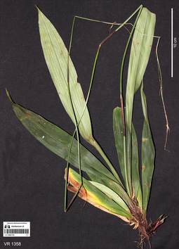
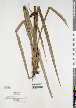
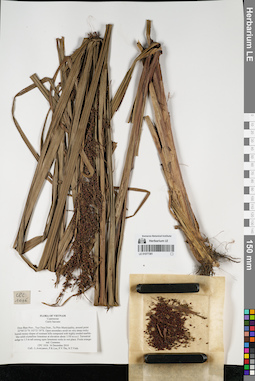
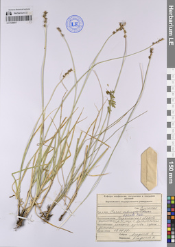
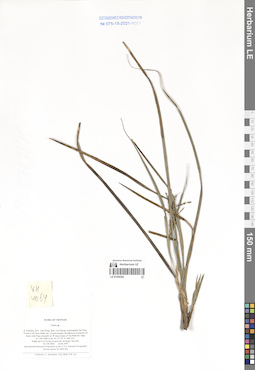
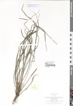
LE 01061125
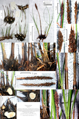
Carex trongii K.K.Nguyen det. Averyanov, Leonid Vladimirovich at 20.12.2019
Collectors: Averyanov, Leonid Vladimirovich; Khang Sinh Nguyen; Maisak, Tatiana Viktorovna Field collecting number: VR1358. Collection date: 05.01.2019. Administrative regions: VN - Tinh Ha Giang. Groups of specimens: L. V. Averyanov specimens; L. V. Averyanov photosOriginal label text:FLORA OF VIETNAM
Coordinates (geographic position): 23° 6′ 50.76″ N, 104° 50′ 42.22″ E ±1000 mComment: Cyperaceae
Carex trongii N.K. Khoi
Ha Giang Prov., Quan Ba Distr., Cao Ma Po Commune, Then Van 1 Village, around point 23.11410ºN 104.84506ºE steep rocky slopes composed with highly eroded limestone at elevation 1600–1700 m a.s.l. Primary evergreen broad-leaved and coniferous very humid forest. Terrestrial sedge on shady steep rocky slope. Leaves dark green. Locally very common. 5 October 2019, L. Averyanov, Nguyen Sinh Khang, T. Maisak, VR 1358.
All photos © L. Averyanov & K.S. Nguyen
Record creation: 2019-12-31, Аверьянов Леонид ВладимировичCitation: Specimen LE 01061125 // Virtual herbarium of Komarov Botanical Institute RAS — http://re.herbariumle.ru/01061125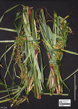
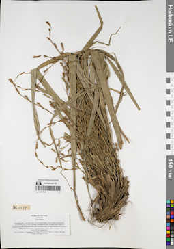
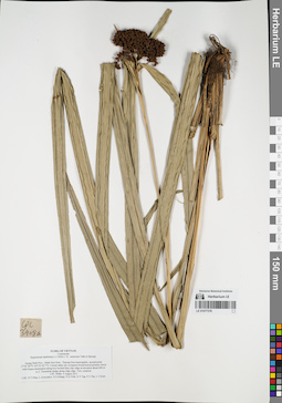
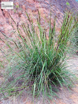
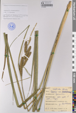
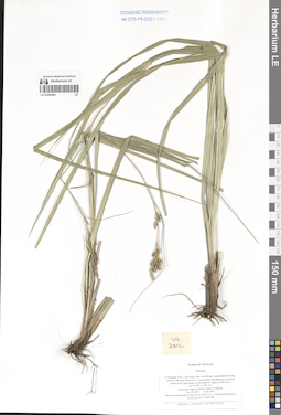
LE 01061165
Carex baccans Nees det. Averyanov, Leonid Vladimirovich at 04.10.2019
Collectors: Averyanov, Leonid Vladimirovich; Khang Sinh Nguyen; Maisak, Tatiana Viktorovna Field collecting number: VR1302. Collection date: 04.10.2019. Administrative regions: VN - Tinh Ha Giang. Groups of specimens: L. V. Averyanov specimens; L. V. Averyanov photosOriginal label text:FLORA OF VIETNAM
Coordinates (geographic position): 23° 5′ 40.27″ N, 104° 50′ 53.92″ E ±1000 mComment: Cyperaceae
Carex baccans Nees
Ha Giang Prov., Quan Ba Distr., Cao Ma Po Commune, Then Van 1 Village, Binh Mountain, around point 23.09452ºN 104.84831ºE, steep rocky slopes composed with highly eroded limestone at elevation 1400–1600 m a.s.l. Remnants of primary evergreen broad-leaved very humid forest with plantation of “wild-grown” Amomum. Terrestrial sedge among mossy rocks in open place. Common. 4 October 2019, L. Averyanov, Nguyen Sinh Khang, T. Maisak, VR 1302.
All photos © L. Averyanov & K.S. Nguyen
Record creation: 2019-12-31, Аверьянов Леонид ВладимировичCitation: Specimen LE 01061165 // Virtual herbarium of Komarov Botanical Institute RAS — http://re.herbariumle.ru/01061165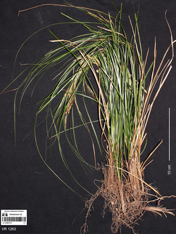
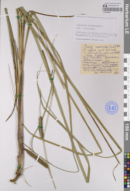
LE 01061275
Carex sp. det. Averyanov, Leonid Vladimirovich at 04.10.2019
Collectors: Averyanov, Leonid Vladimirovich; Khang Sinh Nguyen; Maisak, Tatiana Viktorovna Field collecting number: VR1263. Collection date: 04.10.2019. Administrative regions: VN - Tinh Ha Giang. Groups of specimens: L. V. Averyanov specimens; L. V. Averyanov photosOriginal label text:FLORA OF VIETNAM
Coordinates (geographic position): 23° 5′ 40.27″ N, 104° 50′ 53.92″ E ±1000 mComment: Cyperaceae
Carex sp. 2
Ha Giang Prov., Quan Ba Distr., Cao Ma Po Commune, Then Van 1 Village, Binh Mountain, around point 23.09452ºN 104.84831ºE, steep rocky slopes composed with highly eroded limestone at elevation 1400–1600 m a.s.l. Remnants of primary evergreen broad-leaved very humid forest with plantation of “wild-grown” Amomum. Lithophytic sedge on open vertical travertine deposits along small stream. Locally very common. 4 October 2019, L. Averyanov, Nguyen Sinh Khang, T. Maisak, VR 1263.
All photos © L. Averyanov & K.S. Nguyen
Record creation: 2019-12-30, Аверьянов Леонид ВладимировичCitation: Specimen LE 01061275 // Virtual herbarium of Komarov Botanical Institute RAS — http://re.herbariumle.ru/01061275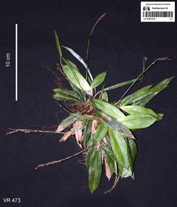
LE 01061478
Carex oblanceolata T.Koyama det. Xiao Feng at 19.04.2018
Additional identifications: Carex trongii K.K.Nguyen det. Xiao Feng at 19.04.2018 Collectors: Averyanov, Leonid Vladimirovich; Khang Sinh Nguyen; Chuong Quang Ngan; Maisak, Tatiana Viktorovna Field collecting number: VR473. Collection date: 19.04.2018. Administrative regions: VN - Tinh Ha Giang. Groups of specimens: L. V. Averyanov specimens; L. V. Averyanov photosOriginal label text:FLORA OF VIETNAM
Coordinates (geographic position): 23° 7′ 40.3″ N, 104° 57′ 11.2″ E ±1000 mComment: Cyperaceae
Carex oblanceolata T. Koyama
( = Carex trongii K.K. Nguyen)
Ha Giang prov., Quan Ba distr., Bat Dai Son Nature Reserve, Thanh Van commune, Tan village, Thong (Conifer) Mountain, around point 23º07ʹ40.3ʺN 104º57ʹ11.2ʺE, at elevation 1000-1195 m a.s.l., karstic, highly eroded mountains composed of solid marble-like limestone, primary evergreen broad-leaved and coniferous (with Pseudotsuga sinensis) humid forest on steep rocky slopes near mountain tops. Lithophyte on mossy rocks. Common. 19 April 2018, L. Averyanov, Nguyen Sinh Khang, Chuong Quang Ngan, T. Maisak, VR 473.
All photos © L. Averyanov & K.S. Nguyen
Record creation: 2019-08-03, Аверьянов Леонид ВладимировичCitation: Specimen LE 01061478 // Virtual herbarium of Komarov Botanical Institute RAS — http://re.herbariumle.ru/01061478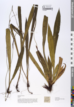
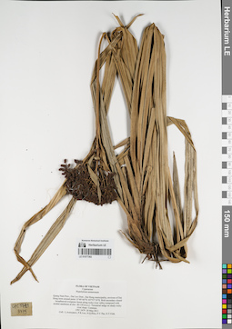
LE 01066860
Carex trongii K.K.Nguyen det. Averyanov, Leonid Vladimirovich at 10.12.2019
Collectors: Averyanov, Leonid Vladimirovich; Khang Sinh Nguyen; Maisak, Tatiana Viktorovna Field collecting number: VR1358. Collection date: 05.10.2019. Administrative regions: VN - Tinh Ha Giang. Groups of specimens: L. V. Averyanov specimens; L. V. Averyanov herbariumOriginal label text:FLORA OF VIETNAM Cyperaceae Carex trongii N.K. Khoi Ha Giang Prov., Quan Ba Distr., Cao Ma Po Commune, Then Van 1 Village, around point 23.11410ºN 104.84506ºE steep rocky slopes composed with highly eroded limestone at elevation 1600–1700 m a.s.l. Primary evergreen broad-leaved and coniferous very humid forest. Terrestrial sedge on shady steep rocky slope. Leaves dark green. Locally very common. 5 October 2019, L. Averyanov, Nguyen Sinh Khang, T. Maisak, VR 1358.
Coordinates (geographic position): 23° 6′ 50.76″ N, 104° 50′ 42.22″ E ±1000 mRecord creation: 2019-12-31, Leonid Averyanov, PhotoScan D1Citation: Specimen LE 01066860 // Virtual herbarium of Komarov Botanical Institute RAS — http://re.herbariumle.ru/01066860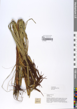
LE 01066894
Carex baccans Nees det. Averyanov, Leonid Vladimirovich at 04.10.2019
Collectors: Averyanov, Leonid Vladimirovich; Khang Sinh Nguyen; Maisak, Tatiana Viktorovna Field collecting number: VR1302. Collection date: 04.10.2019. Administrative regions: VN - Tinh Ha Giang. Groups of specimens: L. V. Averyanov specimens; L. V. Averyanov herbariumOriginal label text:FLORA OF VIETNAM Cyperaceae Carex baccans Nees Ha Giang Prov., Quan Ba Distr., Cao Ma Po Commune, Then Van 1 Village, Binh Mountain, around point 23.09452ºN 104.84831ºE, steep rocky slopes composed with highly eroded limestone at elevation 1400–1600 m a.s.l. Remnants of primary evergreen broad-leaved very humid forest with plantation of “wild-grown” Amomum. Terrestrial sedge among mossy rocks in open place. Common. 4 October 2019, L. Averyanov, Nguyen Sinh Khang, T. Maisak, VR 1302.
Coordinates (geographic position): 23° 5′ 40.27″ N, 104° 50′ 53.92″ E ±1000 mRecord creation: 2019-12-31, Leonid Averyanov, PhotoScan D1Citation: Specimen LE 01066894 // Virtual herbarium of Komarov Botanical Institute RAS — http://re.herbariumle.ru/01066894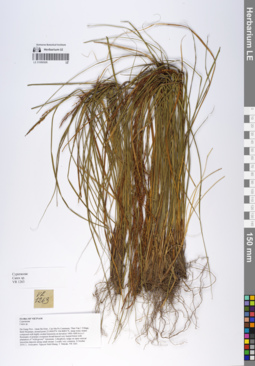
LE 01066926
Carex sp. det. Averyanov, Leonid Vladimirovich at 04.10.2019
Collectors: Averyanov, Leonid Vladimirovich; Khang Sinh Nguyen; Maisak, Tatiana Viktorovna Field collecting number: VR1263. Collection date: 04.10.2019. Administrative regions: VN - Tinh Ha Giang. Groups of specimens: L. V. Averyanov specimens; L. V. Averyanov herbariumOriginal label text:FLORA OF VIETNAM Cyperaceae Carex sp. 2 Ha Giang Prov., Quan Ba Distr., Cao Ma Po Commune, Then Van 1 Village, Binh Mountain, around point 23.09452ºN 104.84831ºE, steep rocky slopes composed with highly eroded limestone at elevation 1400–1600 m a.s.l. Remnants of primary evergreen broad-leaved very humid forest with plantation of “wild-grown” Amomum. Lithophytic sedge on open vertical travertine deposits along small stream. Locally very common. 4 October 2019, L. Averyanov, Nguyen Sinh Khang, T. Maisak, VR 1263.
Coordinates (geographic position): 23° 5′ 40.27″ N, 104° 50′ 53.92″ E ±1000 mRecord creation: 2019-12-31, Leonid Averyanov, PhotoScan D1Citation: Specimen LE 01066926 // Virtual herbarium of Komarov Botanical Institute RAS — http://re.herbariumle.ru/01066926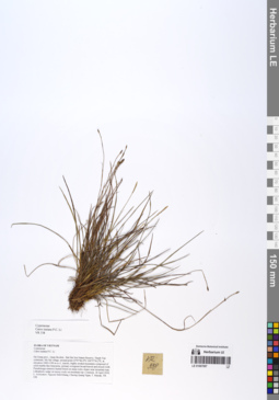
LE 01067097
Carex tsaiana P.C.Li det. Averyanov, Leonid Vladimirovich at 10.12.2019
Collectors: Averyanov, Leonid Vladimirovich; Khang Sinh Nguyen; Maisak, Tatiana Viktorovna; Chuong Quang Ngan Field collecting number: VR338. Collection date: 18.04.2018. Administrative regions: VN - Tinh Ha Giang. Groups of specimens: L. V. Averyanov specimens; L. V. Averyanov herbariumOriginal label text:FLORA OF VIETNAM Cyperaceae Carex tsaiana P.C. Li Ha Giang prov., Quan Ba distr., Bat Dai Son Nature Reserve, Thanh Van commune, Mo Sai village, around point 23º07ʹ46.4ʺN 104º57ʹ56.2ʺE, at elevation 1000-1190 m a.s.l., karstic, highly eroded mountains composed of solid marble-like limestone, primary evergreen broad-leaved and mixed (with Pseudotsuga sinensis) humid forest on steep rocky slopes near mountain tops. Lithophytic sedge on mossy rocks on mountain top. Common. 18 April 2018, L. Averyanov, Nguyen Sinh Khang, Chuong Quang Ngan, T. Maisak, VR 338 (HN, LE01058176).
Coordinates (geographic position): 23° 7′ 46.4″ N, 104° 57′ 56.2″ E ±1000 mComment: All photos © L. Averyanov & K.S. Nguyen
Record creation: 2020-01-05, Leonid Averyanov, PhotoScan D1Citation: Specimen LE 01067097 // Virtual herbarium of Komarov Botanical Institute RAS — http://re.herbariumle.ru/01067097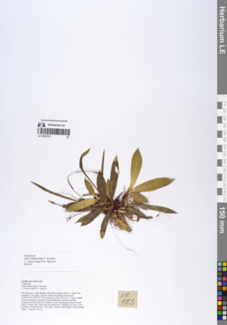
LE 01067215
Carex oblanceolata T.Koyama det. Averyanov, Leonid Vladimirovich at 10.12.2019
Additional identifications: Carex trongii K.K.Nguyen det. Averyanov, Leonid Vladimirovich at 10.12.2019 Collectors: Averyanov, Leonid Vladimirovich; Khang Sinh Nguyen; Maisak, Tatiana Viktorovna; Chuong Quang Ngan Field collecting number: VR473. Collection date: 19.04.2018. Administrative regions: VN - Tinh Ha Giang. Groups of specimens: L. V. Averyanov specimens; L. V. Averyanov herbariumOriginal label text:FLORA OF VIETNAM Cyperaceae Carex oblanceolata T. Koyama ( = Carex trongii K.K. Nguyen) Ha Giang prov., Quan Ba distr., Bat Dai Son Nature Reserve, Thanh Van commune, Tan village, Thong (Conifer) Mountain, around point 23º07ʹ40.3ʺN 104º57ʹ11.2ʺE, at elevation 1000-1195 m a.s.l., karstic, highly eroded mountains composed of solid marble-like limestone, primary evergreen broad-leaved and coniferous (with Pseudotsuga sinensis) humid forest on steep rocky slopes near mountain tops. Lithophyte on mossy rocks. Common. 19 April 2018, L. Averyanov, Nguyen Sinh Khang, Chuong Quang Ngan, T. Maisak, VR 473 (HN, LE01061478).
Coordinates (geographic position): 23° 7′ 40.3″ N, 104° 57′ 11.2″ E ±1000 mComment: All photos © L. Averyanov & K.S. Nguyen
Record creation: 2020-01-05, Leonid Averyanov, PhotoScan D1Citation: Specimen LE 01067215 // Virtual herbarium of Komarov Botanical Institute RAS — http://re.herbariumle.ru/01067215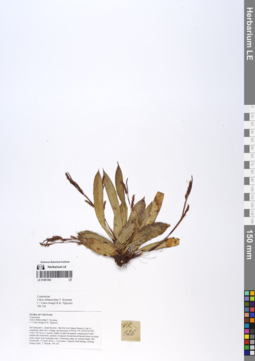
LE 01067293
Carex oblanceolata T.Koyama det. Averyanov, Leonid Vladimirovich at 10.12.2019
Additional identifications: Carex trongii K.K.Nguyen det. Averyanov, Leonid Vladimirovich at 10.12.2019 Collectors: Averyanov, Leonid Vladimirovich; Khang Sinh Nguyen; Maisak, Tatiana Viktorovna Field collecting number: VR126. Collection date: 14.04.2019. Administrative regions: VN - Tinh Ha Giang. Groups of specimens: L. V. Averyanov specimens; L. V. Averyanov herbariumOriginal label text:FLORA OF VIETNAM Cyperaceae Carex oblanceolata T. Koyama ( = Carex trongii K.K. Nguyen) Ha Giang prov., Quan Ba distr., Bat Dai Son Nature Reserve, Can Ty commune, Dau Cau 1 village, around point 23º05ʹ26.3ʺN 105º01ʹ03.0ʺE, 1100-1150 m a.s.l., karstic, highly eroded mountains composed of solid marble-like limestone, primary evergreen broad-leaved humid forest on steep rocky slopes near mountain tops. Clustering sedge on vertical shady cliff. Occasional. 14 April 2018, L. Averyanov, Nguyen Sinh Khang, Chuong Quang Ngan, T. Maisak, VR 126 (HN, LE01058111).
Comment: All photos © L. Averyanov & K.S. Nguyen
Record creation: 2020-01-05, Leonid Averyanov, PhotoScan D1Citation: Specimen LE 01067293 // Virtual herbarium of Komarov Botanical Institute RAS — http://re.herbariumle.ru/01067293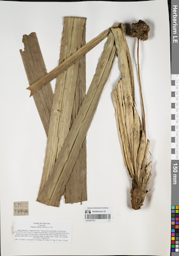
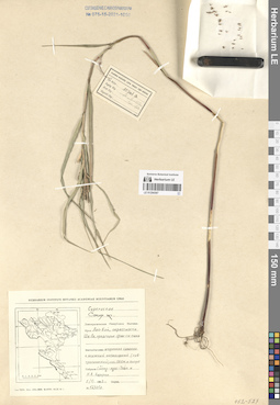
LE 01077371
Mapania palustris (Boeckl.) F. Vill det. Tien Hiep Nguyen at 06.08.2011
Collectors: Tien Hiep Nguyen; et al. Field collecting number: CPC3994. Collection date: 06.08.2011. Administrative regions: VN - Tinh Quang Binh. Groups of specimens: L. V. Averyanov specimens; L. V. Averyanov herbarium; Соглашение Минобрнауки №075-15-2021-1056Original label text:FLORA OF VIETNAM
Cyperaceae
Mapania palustris (Boeckl.) F.Vill.
Quang Binh Prov., Minh Hoa Distr., Thuong Hoa municipality, around point 17°41′25.6”N 105°53′40.4”E.
Humid closed primary evergreen broad-leaved forest on shady rocky slope of stream valley composed with solid crystalline limestone at elevation about 460 m a.s.l.
Terrestrial sedge on shady slope. Locally very common.
CPC 3994 6 August 2011
Coll.: N.T.Hiep, L.Averyanov, N.S.Khang, N.Q.Vinh, N.V.Tap, P.V.The, L.T.Kien.
Coordinates (geographic position): 17° 41′ 25.6″ N, 105° 53′ 40.4″ E ±1000 mRecord creation: 2021-11-09, Leonid Averyanov, PhotoScan D2. Processing status: work_status_1Citation: Specimen LE 01077371 // Virtual herbarium of Komarov Botanical Institute RAS — http://re.herbariumle.ru/01077371Cyperaceae
Mapania palustris (Boeckl.) F.Vill.
Quang Binh Prov., Minh Hoa Distr., Thuong Hoa municipality, around point 17°41′25.6”N 105°53′40.4”E.
Humid closed primary evergreen broad-leaved forest on shady rocky slope of stream valley composed with solid crystalline limestone at elevation about 460 m a.s.l.
Terrestrial sedge on shady slope. Locally very common.
CPC 3994 6 August 2011
Coll.: N.T.Hiep, L.Averyanov, N.S.Khang, N.Q.Vinh, N.V.Tap, P.V.The, L.T.Kien.
LE 01077372
Hypolytrum nemorum (Vahl) Spreng. det. Averyanov, Leonid Vladimirovich at 08.05.2011
Collectors: Averyanov, Leonid Vladimirovich; et al. Field collecting number: CPC2930. Collection date: 08.05.2011. Administrative regions: VN - Tinh Quang Tri. Groups of specimens: L. V. Averyanov specimens; L. V. Averyanov herbarium; Соглашение Минобрнауки №075-15-2021-1056Original label text:FLORA OF VIETNAM
Cyperaceae
Hypolythrum nemorosum
Quang Tri Prov., Huong Hoa Distr., Huong Lap municipality, Cup village, around point 16°55′11”N 106°34′36”E.
Poor remnants of primary broadleaved evergreen forest on very steep slopes of river valley composed with stratified shale at elev. about 350 m a.s.l.
Terrestrial sedge on steep shady river slope. Common.
CPC 2930 8 May 2011
Coll.: L.Averyanov, P.K.Loc, N.Q.Hieu, P.V.The, N.T.Vinh.
Coordinates (geographic position): 16° 55′ 11″ N, 106° 34′ 36″ E ±1000 mRecord creation: 2021-11-09, Leonid Averyanov, PhotoScan D2. Processing status: work_status_1Citation: Specimen LE 01077372 // Virtual herbarium of Komarov Botanical Institute RAS — http://re.herbariumle.ru/01077372Cyperaceae
Hypolythrum nemorosum
Quang Tri Prov., Huong Hoa Distr., Huong Lap municipality, Cup village, around point 16°55′11”N 106°34′36”E.
Poor remnants of primary broadleaved evergreen forest on very steep slopes of river valley composed with stratified shale at elev. about 350 m a.s.l.
Terrestrial sedge on steep shady river slope. Common.
CPC 2930 8 May 2011
Coll.: L.Averyanov, P.K.Loc, N.Q.Hieu, P.V.The, N.T.Vinh.
LE 01077373
Hypolytrum nemorum (Vahl) Spreng. det. Averyanov, Leonid Vladimirovich at 05.05.2011
Collectors: Averyanov, Leonid Vladimirovich; et al. Field collecting number: CPC2757. Collection date: 05.05.2011. Administrative regions: VN - Tinh Quang Binh. Groups of specimens: L. V. Averyanov specimens; L. V. Averyanov herbarium; Соглашение Минобрнауки №075-15-2021-1056Original label text:FLORA OF VIETNAM
Cyperaceae
Hypolytrum nemorosum
Quang Binh Prov., Le Thuy Distr., Kim Thuy municipality, Ho village, around point 16°57′48”N 106°35′34”E.
Highly destroyed primary broadleaved evergreen forest on shale on very steep slopes and along mountain ridge at elev. about 800 m a.s.l.
Terrestrial sedge on steep rocky slope. Occasional.
CPC 2757 5 May 2011
Coll.: L.Averyanov, P.K.Loc, N.Q.Hieu, P.V.The, N.T.Vinh.
Coordinates (geographic position): 16° 57′ 48″ N, 106° 35′ 34″ E ±1000 mRecord creation: 2021-11-09, Leonid Averyanov, PhotoScan D2. Processing status: work_status_1Citation: Specimen LE 01077373 // Virtual herbarium of Komarov Botanical Institute RAS — http://re.herbariumle.ru/01077373Cyperaceae
Hypolytrum nemorosum
Quang Binh Prov., Le Thuy Distr., Kim Thuy municipality, Ho village, around point 16°57′48”N 106°35′34”E.
Highly destroyed primary broadleaved evergreen forest on shale on very steep slopes and along mountain ridge at elev. about 800 m a.s.l.
Terrestrial sedge on steep rocky slope. Occasional.
CPC 2757 5 May 2011
Coll.: L.Averyanov, P.K.Loc, N.Q.Hieu, P.V.The, N.T.Vinh.
LE 01077374
Carex indica Wahlenb det. Averyanov, Leonid Vladimirovich at 25.03.2011
Collectors: Nguyen Quang Hieu; et al. Field collecting number: CPC1577. Collection date: 25.03.2011. Administrative regions: VN - Tinh Hoa Binh. Groups of specimens: L. V. Averyanov specimens; L. V. Averyanov herbarium; Соглашение Минобрнауки №075-15-2021-1056Original label text:FLORA OF VIETNAM
Cyperaceae
Carex indica
Hoa Binh Prov., Lac Son Distr., Tu Do Municipality, Mon village, around point 20°25′29”N 105°19′36”E.
Primary broadleaved forest on steep rocky slopes of remnant mountain composed with solid crystalline highly eroded limestone at elevation about 500-700 m a.s.l.
Terrestrial sedge in shady place. Common.
CPC 1577 25 March 2011
Coll.: N.Q.Hieu, L.Averyanov, N.T.Hiep, P.K.Loc, P.V.The, N.T.Vinh, T.B.Ngan, N.Tap, D.D.Dao, V.T.Ha.
Coordinates (geographic position): 20° 25′ 29″ N, 105° 19′ 36″ E ±1000 mRecord creation: 2021-11-09, Leonid Averyanov, PhotoScan D2. Processing status: work_status_1Citation: Specimen LE 01077374 // Virtual herbarium of Komarov Botanical Institute RAS — http://re.herbariumle.ru/01077374Cyperaceae
Carex indica
Hoa Binh Prov., Lac Son Distr., Tu Do Municipality, Mon village, around point 20°25′29”N 105°19′36”E.
Primary broadleaved forest on steep rocky slopes of remnant mountain composed with solid crystalline highly eroded limestone at elevation about 500-700 m a.s.l.
Terrestrial sedge in shady place. Common.
CPC 1577 25 March 2011
Coll.: N.Q.Hieu, L.Averyanov, N.T.Hiep, P.K.Loc, P.V.The, N.T.Vinh, T.B.Ngan, N.Tap, D.D.Dao, V.T.Ha.
LE 01077375
Carex baccans Nees det. Averyanov, Leonid Vladimirovich at 24.10.2013
Collectors: Averyanov, Leonid Vladimirovich; et al. Field collecting number: CPC6198. Collection date: 24.10.2013. Administrative regions: VN - Tinh Nghe An. Groups of specimens: L. V. Averyanov specimens; L. V. Averyanov herbarium; Соглашение Минобрнауки №075-15-2021-1056Original label text:FLORA OF VIETNAM
Cyperaceae
Carex baccans
Nghe An Prov., Ky Son Distr., Na Ngoi Municipality, eastern slopes of Phu Xai Lai Leng Mountain.
Primary very humid broad-leaved forest on steep mountain slopes composed of sandstone and gray shale at elevation about 2300 m a.s.l. around point 19°12′23.3″N 104°11′33.7″E.
Terrestrial sedge in rather open places. Fruits red. Very common.
24 October 2013 CPC 6198
Coll.: L.Averyanov, N.T.Hiep, N.S.Khang, L.M.Tuan, N.A.Trang, L.H.Dan
Coordinates (geographic position): 19° 12′ 23.3″ N, 104° 11′ 33.7″ E ±1000 mRecord creation: 2021-11-09, Leonid Averyanov, PhotoScan D2. Processing status: work_status_1Citation: Specimen LE 01077375 // Virtual herbarium of Komarov Botanical Institute RAS — http://re.herbariumle.ru/01077375Cyperaceae
Carex baccans
Nghe An Prov., Ky Son Distr., Na Ngoi Municipality, eastern slopes of Phu Xai Lai Leng Mountain.
Primary very humid broad-leaved forest on steep mountain slopes composed of sandstone and gray shale at elevation about 2300 m a.s.l. around point 19°12′23.3″N 104°11′33.7″E.
Terrestrial sedge in rather open places. Fruits red. Very common.
24 October 2013 CPC 6198
Coll.: L.Averyanov, N.T.Hiep, N.S.Khang, L.M.Tuan, N.A.Trang, L.H.Dan
LE 01077376
Hypolytrum nemorum (Vahl) Spreng. det. Averyanov, Leonid Vladimirovich at 07.11.2013
Collectors: Averyanov, Leonid Vladimirovich; et al. Field collecting number: CPC6823. Collection date: 07.11.2013. Administrative regions: VN - Tinh Thanh Hoa. Groups of specimens: L. V. Averyanov specimens; L. V. Averyanov herbarium; Соглашение Минобрнауки №075-15-2021-1056Original label text:FLORA OF VIETNAM
Cyperaceae
Hypolytrum nemorosum
Thanh Hoa Prov., Thuong Xuan Distr., Van Xuan Municipality, Quan village, Xuan Lien Natural Reserve.
Secondary broad-leaved evergreen forest on sandstone hills at elevation 300-500 m a.s.l. around point 19°51′27.0″N 105°12′46.0″E.
Terrestrial sedge on shady steep slope. Very common.
7 November 2013 CPC 6823
Coll.: L.Averyanov, N.T.Hiep, N.S.Khang, N.D.Thang, L.D.Qui
LE 01077377
Carex indica Wahlenb det. Averyanov, Leonid Vladimirovich at 15.03.2005
Collectors: Averyanov, Leonid Vladimirovich; et al. Field collecting number: HAL6786. Collection date: 15.03.2005. Administrative regions: VN - Tinh Lang Son. Groups of specimens: L. V. Averyanov specimens; L. V. Averyanov herbarium; Соглашение Минобрнауки №075-15-2021-1056Original label text:FLORA OF VIETNAM
Cyperaceae
Carex indica
Vietnam, Lang Son Prov., Bac Son Distr., Tan Tri Municipality, around Na Mau village, Khau Kieng ridge composed with shale.
Deeply degraded remnants of primary and secondary broadleaved evergreen wet forest with bamboo at elevation 800-1100 m a.s.l.
Terrestrial sedge on shady rocky slope. Common.
HAL 6786 15 March 2005.
Collectors: L.Averyanov, N.T.Hiep, P.V.The, A.Averyanova.
Record creation: 2021-11-09, Leonid Averyanov, PhotoScan D2. Processing status: work_status_1Citation: Specimen LE 01077377 // Virtual herbarium of Komarov Botanical Institute RAS — http://re.herbariumle.ru/01077377Cyperaceae
Carex indica
Vietnam, Lang Son Prov., Bac Son Distr., Tan Tri Municipality, around Na Mau village, Khau Kieng ridge composed with shale.
Deeply degraded remnants of primary and secondary broadleaved evergreen wet forest with bamboo at elevation 800-1100 m a.s.l.
Terrestrial sedge on shady rocky slope. Common.
HAL 6786 15 March 2005.
Collectors: L.Averyanov, N.T.Hiep, P.V.The, A.Averyanova.
LE 01077378
Hypolytrum nemorum (Vahl) Spreng. det. Averyanov, Leonid Vladimirovich at 04.08.2011
Collectors: Tien Hiep Nguyen; et al. Field collecting number: CPC3908a. Collection date: 04.08.2011. Administrative regions: VN - Tinh Quang Binh. Groups of specimens: L. V. Averyanov specimens; L. V. Averyanov herbarium; Соглашение Минобрнауки №075-15-2021-1056Original label text:FLORA OF VIETNAM
Cyperaceae
Hypolytrum latifolium L.C.Rich (= H. nemorum Vahl et Spreng).
Quang Binh Prov., Minh Hoa Distr., Thuong Hoa municipality, around point 17°41′28”N 105°53′42.7”E.
Closed rather dry evergreen broad-leaved primary forest with Hopea domination along low leveled lime clay ridge at elevation about 600 m a.s.l.
Terrestrial sledge along ridge edge. Very common.
CPC 3908a 4 August 2011
Coll.: N.T.Hiep, L.Averyanov, N.S.Khang, N.Q.Vinh, N.V.Tap, P.V.The, L.T.Kien.
Coordinates (geographic position): 17° 41′ 28″ N, 105° 53′ 42.7″ E ±1000 mRecord creation: 2021-11-09, Leonid Averyanov, PhotoScan D2. Processing status: work_status_1Citation: Specimen LE 01077378 // Virtual herbarium of Komarov Botanical Institute RAS — http://re.herbariumle.ru/01077378Cyperaceae
Hypolytrum latifolium L.C.Rich (= H. nemorum Vahl et Spreng).
Quang Binh Prov., Minh Hoa Distr., Thuong Hoa municipality, around point 17°41′28”N 105°53′42.7”E.
Closed rather dry evergreen broad-leaved primary forest with Hopea domination along low leveled lime clay ridge at elevation about 600 m a.s.l.
Terrestrial sledge along ridge edge. Very common.
CPC 3908a 4 August 2011
Coll.: N.T.Hiep, L.Averyanov, N.S.Khang, N.Q.Vinh, N.V.Tap, P.V.The, L.T.Kien.
LE 01077379
Hypolytrum nemorum (Vahl) Spreng. det. Averyanov, Leonid Vladimirovich at 12.05.2011
Collectors: Averyanov, Leonid Vladimirovich; et al. Field collecting number: CPC3076. Collection date: 12.05.2011. Administrative regions: VN - Tinh Thua Thien-Hue. Groups of specimens: L. V. Averyanov specimens; L. V. Averyanov herbarium; Соглашение Минобрнауки №075-15-2021-1056Original label text:FLORA OF VIETNAM
Cyperaceae
Hypolytrum nemorosum
Thua Thien - Hue Prov., A Luoi Distr., Huong Nguyen municipality, around point 16°06′04”N 107°27′55”E.
Pristine primary broadleaved and mixed (with Dacrycarpus imbricatus) evergreen forest along mountain ridge composed with shale at elev. about 1000 m a.s.l.
Terrestrial sedge. Very common.
CPC 3076 12 May 2011
Coll.: L.Averyanov, P.K.Loc, N.Q.Hieu, P.V.The, N.T.Vinh.
Coordinates (geographic position): 16° 6′ 4″ N, 107° 27′ 55″ E ±1000 mRecord creation: 2021-11-09, Leonid Averyanov, PhotoScan D2. Processing status: work_status_1Citation: Specimen LE 01077379 // Virtual herbarium of Komarov Botanical Institute RAS — http://re.herbariumle.ru/01077379Cyperaceae
Hypolytrum nemorosum
Thua Thien - Hue Prov., A Luoi Distr., Huong Nguyen municipality, around point 16°06′04”N 107°27′55”E.
Pristine primary broadleaved and mixed (with Dacrycarpus imbricatus) evergreen forest along mountain ridge composed with shale at elev. about 1000 m a.s.l.
Terrestrial sedge. Very common.
CPC 3076 12 May 2011
Coll.: L.Averyanov, P.K.Loc, N.Q.Hieu, P.V.The, N.T.Vinh.
LE 01077380
Hypolytrum nemorum (Vahl) Spreng. det. Averyanov, Leonid Vladimirovich at 16.05.2011
Collectors: Averyanov, Leonid Vladimirovich; et al. Field collecting number: CPC3294. Collection date: 16.05.2011. Administrative regions: VN - Thanh Pho GJa Nang. Groups of specimens: L. V. Averyanov specimens; L. V. Averyanov herbarium; Соглашение Минобрнауки №075-15-2021-1056Original label text:FLORA OF VIETNAM
Cyperaceae
Hypolythrum nemorosum
Da Nang City, Hoa Vang Distr., Hoa Ninh municipality, Ba Na – Nui Chua protected area, around point 16°00′05”N 108°01′15”E.
Highly destroyed primary and secondary broadleaved evergreen forest on very steep mountain slopes with granite mother rocks at elev. 800-900 m a.s.l.
Terrerstrial sedge on very steep shady slope. Very common.
CPC 3294 16 May 2011
Coll.: L.Averyanov, P.K.Loc, N.Q.Hieu, P.V.The, N.T.Vinh.
Coordinates (geographic position): 16° 0′ 5″ N, 108° 1′ 15″ E ±1000 mRecord creation: 2021-11-09, Leonid Averyanov, PhotoScan D2. Processing status: work_status_1Citation: Specimen LE 01077380 // Virtual herbarium of Komarov Botanical Institute RAS — http://re.herbariumle.ru/01077380Cyperaceae
Hypolythrum nemorosum
Da Nang City, Hoa Vang Distr., Hoa Ninh municipality, Ba Na – Nui Chua protected area, around point 16°00′05”N 108°01′15”E.
Highly destroyed primary and secondary broadleaved evergreen forest on very steep mountain slopes with granite mother rocks at elev. 800-900 m a.s.l.
Terrerstrial sedge on very steep shady slope. Very common.
CPC 3294 16 May 2011
Coll.: L.Averyanov, P.K.Loc, N.Q.Hieu, P.V.The, N.T.Vinh.
LE 01077381
Carex baccans Nees det. Averyanov, Leonid Vladimirovich at 16.12.2010
Collectors: Averyanov, Leonid Vladimirovich; et al. Field collecting number: CPC1016. Collection date: 16.12.2010. Administrative regions: VN - Tinh Dien Bien. Groups of specimens: L. V. Averyanov specimens; L. V. Averyanov herbarium; Соглашение Минобрнауки №075-15-2021-1056Original label text:FLORA OF VIETNAM
Cyperaceae
Carex baccans
Dien Bien Prov., Tua Chua Distr., Ta Phin Municipality, around point 22°00′21”N 103°21′39”E.
Open secondary scrub on very steep rocky humid mossy slopes of remnant hills composed with highly eroded marble-like solid crystalline limestone at elevation about 1150 m a.s.l.
Terrestrial sedge to 1.5 m tall among open limestone rocks in wet place. Fruits orange-red. Common.
CPC 1016 16 December 2010
Coll.: L.Averyanov, P.K.Loc, P.V.The, N.T.Vinh.
Coordinates (geographic position): 22° 0′ 21″ N, 103° 21′ 39″ E ±1000 mRecord creation: 2021-11-09, Leonid Averyanov, PhotoScan D2. Processing status: work_status_1Citation: Specimen LE 01077381 // Virtual herbarium of Komarov Botanical Institute RAS — http://re.herbariumle.ru/01077381Cyperaceae
Carex baccans
Dien Bien Prov., Tua Chua Distr., Ta Phin Municipality, around point 22°00′21”N 103°21′39”E.
Open secondary scrub on very steep rocky humid mossy slopes of remnant hills composed with highly eroded marble-like solid crystalline limestone at elevation about 1150 m a.s.l.
Terrestrial sedge to 1.5 m tall among open limestone rocks in wet place. Fruits orange-red. Common.
CPC 1016 16 December 2010
Coll.: L.Averyanov, P.K.Loc, P.V.The, N.T.Vinh.
LE 01077382
Hypolytrum nemorum (Vahl) Spreng. det. Averyanov, Leonid Vladimirovich at 20.05.2011
Collectors: Averyanov, Leonid Vladimirovich; et al. Field collecting number: CPC3479. Collection date: 20.05.2011. Administrative regions: VN - Tinh Quang Nam. Groups of specimens: L. V. Averyanov specimens; L. V. Averyanov herbarium; Соглашение Минобрнауки №075-15-2021-1056Original label text:FLORA OF VIETNAM
Cyperaceae
Hypolytrum nemorosum
Quang Nam Prov., Dai Loc Distr., Dai Hong municipality, environs of Dai Hong town around point 15°49′44”N 107°57′19”E. Rich secondary closed broadleaved evergreen forest along rocky river valley composed with eroded sandstone at elev. 80-150 m a.s.l. Terrestrial sedge on shady rocky river slope. Common.
CPC 3479 20 May 2011
Coll.: L.Averyanov, P.K.Loc, N.Q.Hieu, P.V.The, N.T.Vinh.
Coordinates (geographic position): 15° 49′ 44″ N, 107° 57′ 19″ E ±1000 mRecord creation: 2021-11-09, Leonid Averyanov, PhotoScan D2. Processing status: work_status_1Citation: Specimen LE 01077382 // Virtual herbarium of Komarov Botanical Institute RAS — http://re.herbariumle.ru/01077382Cyperaceae
Hypolytrum nemorosum
Quang Nam Prov., Dai Loc Distr., Dai Hong municipality, environs of Dai Hong town around point 15°49′44”N 107°57′19”E. Rich secondary closed broadleaved evergreen forest along rocky river valley composed with eroded sandstone at elev. 80-150 m a.s.l. Terrestrial sedge on shady rocky river slope. Common.
CPC 3479 20 May 2011
Coll.: L.Averyanov, P.K.Loc, N.Q.Hieu, P.V.The, N.T.Vinh.
LE 01079889
Isotype of Eleocharis fennica Palla ex Kneuck. det. Kneucker, Johann Andreas(`Andrees') at 1901
Additional identifications: Eleocharis uniglumis ssp. uniglumis var. fennica (Palla ex Kneuck.) Hyl. det. Strandhede, Sven Olof at 1966; Eleocharis uniglumis ssp. fennica (Palla ex Kneuck.) T.V. Egorova det. Zinserling (Tsinzerling), Iurij (Yuri, Georgius) Dmitrievitch Collectors: Fontell, Carl Wilhelm Field collecting number: 73. Collection date: 08.1901. Administrative regions: FI - Pohjanmaa. Groups of specimens: Образцы сектора Восточной Европы; Типовые образцы сектора Восточной Европы; A. Kneucker: Cyperaceae (exclus. Carices) et Juncaceae exsiccatae. III Lieferung. 1902Original label text:An grasigen Stellen des Meeresufers bei Jacobstadt in russisch Finnland im mitleren Teile der Provinz Ostrobottnia. Meereshohe.
Coordinates (geographic position): 63° 15′ 4.3″ N, 22° 10′ 51.82″ E ±20000 mComment: Discussions: Opera botanica 10: 2, pp. 130, 138, 148.
Record creation: 2020-09-12, Denis Melnikov, PhotoScan D2Citation: Specimen LE 01079889 // Virtual herbarium of Komarov Botanical Institute RAS — http://re.herbariumle.ru/01079889Lund 1966 S. O. Strandhede.
LE 01122646
Carex thomsonii Boott det. Averyanov, Leonid Vladimirovich at 25.11.2006
Collectors: Averyanov, Leonid Vladimirovich; et al. Field collecting number: HAL10137. Collection date: 25.11.2006. Administrative regions: VN - Tinh Lai Chau. Groups of specimens: L. V. Averyanov specimens; L. V. Averyanov photos; Соглашение Минобрнауки №075-15-2021-1056Original label text:FLORA OF VIETNAM
Fam. Cyperaceae
Carex thomsonii Boott
Lai Chau Prov., Muong Te Distr., around point 22°07’56’’N 102°56’43’’E. Riparian shrubs on rocky steep slopes and bluffs composed with shale limestone along Song Da River valley from Muong Te to Muong Lay at elev. about 225 m a.s.l. Lithophytic sedge-like densely clustering herb on wet open parental rocks and bluffs along water line. Locally common.
HAL 10137 25 Nov. 2006 Photo.
Coll.: Nguyen Tien Hiep, L.Averyanov, Pham Van The.
d-EXSICCATES OF VIETNAMESE FLORA 0087/HAL10137 (HN, LE)
© Nguyen Tien Hiep, L.Averyanov, Phan Ke Loc
All photos © - L. Averyanov
LE 01122647
Carex thomsonii Boott det. Averyanov, Leonid Vladimirovich at 29.04.2008
Collectors: Averyanov, Leonid Vladimirovich; et al. Field collecting number: HAL11847. Collection date: 29.04.2008. Administrative regions: VN - Tinh Lai Chau. Groups of specimens: L. V. Averyanov specimens; L. V. Averyanov photos; Соглашение Минобрнауки №075-15-2021-1056Original label text:FLORA OF VIETNAM
Cyperaceae
Carex thomsonii Boott
Lai Chau Prov., Sinh Ho Distr., Nam Ban Community, around point 22°20’41’’N 103°10’07’’E.
Riparian shrubs on rocky steep slopes and bluffs composed with shale limestone along Nam Na River valley from Muong Lay to Phong Tho at elev. about 225 m a.s.l.
Lithophytic sedge-like dense clustering herb on wet riparian rocks and bluffs along water line. Occasional.
HAL 11847 29 April 2008 photo
Coll.: Pham Van The
All photos © - L. Averyanov
LE 01124616
Gahnia tristis Nees ex Hook. & Arn. det. Nuraliev, M. S. at 07.12.2023
Additional identifications: Gahnia javanica Moritzi det. Averyanov, Leonid Vladimirovich at 08.11.2023 Collectors: Averyanov, Leonid Vladimirovich; Nguyen Van Canh; Truong Ba Vuong; Maisak, Tatiana Viktorovna Field collecting number: AL2793. Collection date: 08.11.2023. Administrative regions: VN - Tinh Lam GJong. Groups of specimens: L. V. Averyanov specimens; L. V. Averyanov photos; Flora of VietnamOriginal label text:FLORA OF VIETNAM
Cyperaceae
Gahnia javanica Moritzi
Lam Dong Province, Lac Duong District, Bidoup Nui Ba National Par, southern slopes of Bidoup Mountain about 10 km to the south from Bidoup peak around point 12º04.076’N 108º38.927E. Open grassy Pinus kesiya forest and woodlands at elevation about 1400–1600 m a.s.l. Large sedge in open place along road. Not rare.
08 November 2023, L. Averyanov, Nguyen Van Canh, Truong Ba Vuong, T. Maisak, AL2793 (photo only).
All photos © - L. Averyanov
LE 01169965
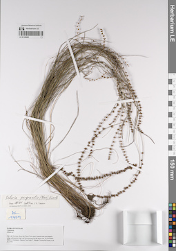
Scleria pergracilis (Nees) Kunth det. Tatanov, Ivan Vladimirovich at 16.01.2022
Collectors: Averyanov, Leonid Vladimirovich; Nguyen Van Canh; Maisak, Tatiana Viktorovna; Truong Ba Vuong Field collecting number: AL 1779. Collection date: 26.11.2022. Administrative regions: VN - Tinh GJak Lak. Groups of specimens: L. V. Averyanov herbarium; Образцы общего сектора; Соглашение Минобрнауки №075-15-2021-1056; Flora of VietnamOriginal label text:Flora of Vietnam
Record creation: 2023-01-16, Иван Владимирович Татанов. Processing status: work_status_1Citation: Specimen LE 01169965 // Virtual herbarium of Komarov Botanical Institute RAS — http://re.herbariumle.ru/01169965Cyperaceae
Scleria sp.
Dak Lak Province, Buon Ma Thuot Town area. Riparian and semi-aquatic sedge cultivated in Dak Lak Province area for the spicy use.
26 Novebmer 2022, L. Averyanov, Nguyen Van Canh, T. Maisak, Truong Ba Vuong et al.
AL 1779
LE 01170238
Cyperus rotundus L. det. Cuong Huu Nguyen at 23.06.2022
Collectors: Cuong Huu Nguyen; et al. Field collecting number: CHKH20220623046. Collection date: 23.06.2022. Administrative regions: VN - Tinh Quang Nam. Groups of specimens: L. V. Averyanov specimens; L. V. Averyanov herbarium; Соглашение Минобрнауки №075-15-2021-1056Original label text:FLORA OF VIETNAM
Record creation: 2023-02-06, Galina Savich, PhotoScan D2.. Processing status: work_status_1Citation: Specimen LE 01170238 // Virtual herbarium of Komarov Botanical Institute RAS — http://re.herbariumle.ru/01170238Cyperaceae
Cyperus rotundus L.
Quang Nam Prov.
Cuong Huu Nguyen et al.
CHKH20220623046
23.06.2022
LE 01170244
Fimbristylis dichotoma (L.) Vahl. det. Cuong Huu Nguyen at 27.06.2022
Collectors: Cuong Huu Nguyen; et al. Field collecting number: CHKH20220627265. Collection date: 27.06.2022. Administrative regions: VN - Tinh Quang Nam. Groups of specimens: L. V. Averyanov specimens; L. V. Averyanov herbarium; Соглашение Минобрнауки №075-15-2021-1056Original label text:FLORA OF VIETNAM
Record creation: 2023-02-06, Galina Savich, PhotoScan D2.. Processing status: work_status_1Citation: Specimen LE 01170244 // Virtual herbarium of Komarov Botanical Institute RAS — http://re.herbariumle.ru/01170244Cyperaceae
Fimbristylis dichotoma (L.) Vahl.
Quang Nam Prov.
Cuong Huu Nguyen et al.
CHKH20220627265
27.06.2022
LE 01177138
Eriophorum vaginatum L. det. Кривенко at 12.06.1970
Collectors: Хрулева Collection date: 12.06.1970. Administrative regions: RU - Leningradskaya Oblast' - Luzhskiy Rayon. Groups of specimens: Образцы сектора Восточной Европы; Соглашение Минобрнауки №075-15-2021-1056Original label text:Сем. Cyperaceae - Осоковые
Пушица влагалищная.
Ленинградская область, Лужская область.
Болото.
LE 01181291
Dryopteris filix-mas (L.) Schott det. Kardakov A. N.
Collectors: Kardakov A. N. Field collecting number: 139. Administrative regions: RU - Kirovskaya Oblast' - Yur'yanskiy Rayon. Groups of specimens: Образцы сектора Восточной Европы; Флора Урала и прилегающих территорий (проект); Соглашение Минобрнауки №075-15-2021-1056; A. Kneucker: Cyperaceae (exclus. Carices) et Juncaceae exsiccatae. III Lieferung. 1902; Из гербария А. Н. Кардакова.Original label text:Смешанный лес, в тени [?].
Coordinates (geographic position): 58° 48′ 47.91″ N, 49° 36′ 36.58″ E ±1000 mRecord creation: 2022-02-23, Denis Melnikov, PhotoScan D2. Processing status: label contains unreadable dataCitation: Specimen LE 01181291 // Virtual herbarium of Komarov Botanical Institute RAS — http://re.herbariumle.ru/01181291Село Загарье Вятского уезда и губернии.
LE 01200517
Carex spicata Huds. det. Agafonov, Vladimir Aleksandrovich at 19.08.1988
Collectors: Agafonov, Vladimir Aleksandrovich Collection date: 19.08.1988. Administrative regions: RU - Voronezhskaya Oblast' - Anninskiy Rayon. Groups of specimens: Образцы сектора Восточной Европы; Соглашение Минобрнауки №075-15-2021-1056; Кафедра морфологии, систематики и географии растений Воронежского государственного университетаOriginal label text:Cyperaceae
Местонахождение: Воронежская область, Аннинский район, окрестности села Архангельское.
Местообитаение: солонец лугово-черноземный.
LE 01246200
Carex rostrata Stokes det. Belysheva, Tatiana Nikolaevna, Notov, Alexander Alexandrovich
Collectors: Belysheva, Tatiana Nikolaevna Field collecting number: 424. Collection date: 12.06.1988. Administrative regions: RU - Tverskaya Oblast' - Ostashkovskiy Rayon. Groups of specimens: Образцы сектора Восточной Европы; Соглашение Минобрнауки №075-15-2021-1056; Гербарий музея Природы Северного КраяOriginal label text:Осока вздутая.
Семейство осоковые Cyperaceae.
Местообитание: берег озера, в озере (в воде).
Местонахождение: Калининская область, Осташковский район, озеро Большой Жетонег.
Гербарий передан в дар директором музея Природы Селигерского Края (Тверская область, Осташковский район, деревня Рогожа) Т. Н. Бельшевой в 2018 г. в связи с его расформированием.
Гербарий обработан П. Г. Ефимовым в 2018
LE 01246201
Carex rostrata Stokes det. Notov, Alexander Alexandrovich at 01.1989
Collectors: Belysheva, Tatiana Nikolaevna Field collecting number: 424. Collection date: 17.06.1988. Administrative regions: RU - Tverskaya Oblast' - Ostashkovskiy Rayon. Groups of specimens: Образцы сектора Восточной Европы; Соглашение Минобрнауки №075-15-2021-1056; Гербарий музея Природы Северного КраяOriginal label text:(Carex inflata auct. vix Huds., Carex utriculata auct., non Boot.)
Осока вздутая
Семейство осоковые - Cyperaceae
Заболоченный низинный луг.
Калининская область, Осташковский район, поворот на Спицыно с Селижаровского шоссе, далее 1 км в лес.
Гербарий передан в дар директором музея Природы Селигерского Края (Тверская область, Осташковский район, деревня Рогожа) Т. Н. Бельшевой в 2018 г. в связи с его расформированием.
Гербарий обработан П. Г. Ефимовым в 2018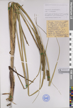
LE 01246202
Carex rostrata Stokes det. Notov, Alexander Alexandrovich at 01.1989
Collectors: Belysheva, Tatiana Nikolaevna Field collecting number: 424. Collection date: 17.06.1988. Administrative regions: RU - Tverskaya Oblast' - Ostashkovskiy Rayon. Groups of specimens: Образцы сектора Восточной Европы; Соглашение Минобрнауки №075-15-2021-1056; Гербарий музея Природы Северного КраяOriginal label text:(Carex inflata auct. vix Huds., Carex utriculata auct., non Boot.)
Осока вздутая
Семейство осоковые - Cyperaceae
Заболоченный низинный луг.
Калининская область, Осташковский район, поворот на Спицыно с Селижаровского шоссе, далее 1 км в лес.
Гербарий передан в дар директором музея Природы Селигерского Края (Тверская область, Осташковский район, деревня Рогожа) Т. Н. Бельшевой в 2018 г. в связи с его расформированием.
Гербарий обработан П. Г. Ефимовым в 2018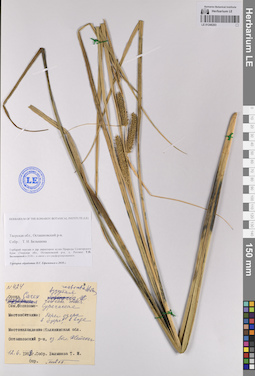
LE 01246203
Carex rostrata Stokes det. Notov, Alexander Alexandrovich, Belysheva, Tatiana Nikolaevna
Collectors: Belysheva, Tatiana Nikolaevna Field collecting number: 424. Collection date: 12.06.1988. Administrative regions: RU - Tverskaya Oblast' - Ostashkovskiy Rayon. Groups of specimens: Образцы сектора Восточной Европы; Соглашение Минобрнауки №075-15-2021-1056; Гербарий музея Природы Северного КраяOriginal label text:Осока вздутая.
Семейство осоковые Cyperaceae.
Местообитание: берег озера, в озере (в воде).
Местонахождение: Калининская область, Осташковский район, озеро Большой Жетонег.
Гербарий передан в дар директором музея Природы Селигерского Края (Тверская область, Осташковский район, деревня Рогожа) Т. Н. Бельшевой в 2018 г. в связи с его расформированием.
Гербарий обработан П. Г. Ефимовым в 2018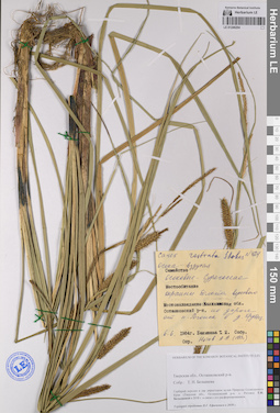
LE 01246204
Carex rostrata Stokes det. Notov, Alexander Alexandrovich at 1989
Collectors: Belysheva, Tatiana Nikolaevna Field collecting number: 424. Collection date: 06.06.1984. Administrative regions: RU - Tverskaya Oblast' - Ostashkovskiy Rayon. Groups of specimens: Образцы сектора Восточной Европы; Соглашение Минобрнауки №075-15-2021-1056Original label text:Осока вздутая.
Семейство осоковые Cyperaceae.
Местообитание: окраины верхового болота.
Местонахождение: Калининская область, Осташковский район, по дороге от поселка Рогожа в деревню Крутец.
Гербарий передан в дар директором музея Природы Селигерского Края (Тверская область, Осташковский район, деревня Рогожа) Т. Н. Бельшевой в 2018 г. в связи с его расформированием.
Гербарий обработан П. Г. Ефимовым в 2018 г.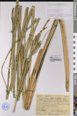
LE 01246205
Carex rostrata Stokes det. Notov, Alexander Alexandrovich
Collectors: Belysheva, Tatiana Nikolaevna Field collecting number: 424. Collection date: 24.06.1984. Administrative regions: RU - Tverskaya Oblast' - Ostashkovskiy Rayon. Groups of specimens: Образцы сектора Восточной Европы; Соглашение Минобрнауки №075-15-2021-1056; Гербарий музея Природы Северного КраяOriginal label text:(Carex inflata auct. vix Huds., Carex utriculata auct., non Boot.)
Осока вздутая.
Семейство осоковые Cyperaceae.
Калининская область, Осташковский район, окрестности деревни Крутец, болотце.Гербарий передан в дар директором музея Природы Селигерского Края (Тверская область, Осташковский район, деревня Рогожа) Т. Н. Бельшевой в 2018 г. в связи с его расформированием.
Гербарий обработан П. Г. Ефимовым в 2018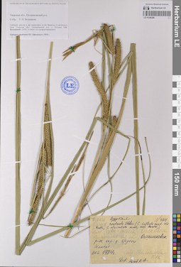
LE 01246206
Carex rostrata Stokes det. Notov, Alexander Alexandrovich
Collectors: Belysheva, Tatiana Nikolaevna Field collecting number: 424. Collection date: 24.06.1984. Administrative regions: RU - Tverskaya Oblast' - Ostashkovskiy Rayon. Groups of specimens: Образцы сектора Восточной Европы; Соглашение Минобрнауки №075-15-2021-1056; Гербарий музея Природы Северного КраяOriginal label text:(Carex inflata auct. vix Huds., Carex utriculata auct., non Boot.)
Осока вздутая.
Семейство осоковые Cyperaceae.
Калининская область, Осташковский район, окрестности деревни Крутец, болотце.Гербарий передан в дар директором музея Природы Селигерского Края (Тверская область, Осташковский район, деревня Рогожа) Т. Н. Бельшевой в 2018 г. в связи с его расформированием.
Гербарий обработан П. Г. Ефимовым в 2018 г.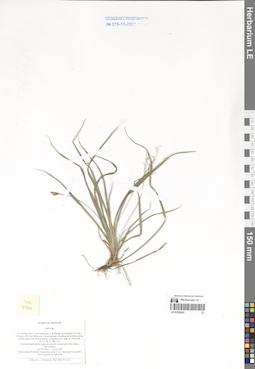
LE 01254361
Carex sp. det. Averyanov, Leonid Vladimirovich at 19.03.1997
Collectors: Averyanov, Leonid Vladimirovich; N.Q. Binh; Phan Ke Loc Field collecting number: VH2910. Collection date: 19.03.1997. Administrative regions: VN - Tinh Lam GJong. Groups of specimens: L. V. Averyanov specimens; L. V. Averyanov herbarium; Соглашение Минобрнауки №075-15-2021-1056; Flora of VietnamOriginal label text:FLORA OF VIETNAM
Cyperaceae
Carex sp.
S. Vietnam, Prov. Lam Dong, distr. Lac Duong, municipalite Da Chay, 35 km to NE from Dalat city. Closed primary broadleaved mt forest along stream canyon on W macroslope of Gia Rinh mt. ridge at 1500 m alt. (N 12° 09', E 108° 41').
Terrestrial and epilitic sedge on open dry steep rocky river slopes. Not common.
No VH 2910 19.03.1997
International Botanical Expedition of the U.S.A. National Geographic
Society (grant No 5803-96)
___________________________________________________________
Collectors: L. Averyanov, N.Q. Binh, P.K. Loc
LE 01254362
Carex sp. det. Averyanov, Leonid Vladimirovich at 18.04.1997
Collectors: Averyanov, Leonid Vladimirovich; N.Q. Binh; Phan Ke Loc Field collecting number: VH4064. Collection date: 18.04.1997. Administrative regions: VN - Tinh Lam GJong. Groups of specimens: L. V. Averyanov specimens; L. V. Averyanov herbarium; Соглашение Минобрнауки №075-15-2021-1056; Flora of VietnamOriginal label text:FLORA OF VIETNAM
Cyperaceae
Carex sp.
S. Vietnam, Prov. Lam Dong, distr. Lac Duong, municipalite Da Chay, 35 km to NE from Dalat city. Closed primary broadleaved evergreen mt forest with Pinus krempfii on W macroslope of Gia Rinh mt. ridge at 1700-1800 m alt. (N 12° 09', E 108° 41'). Sedge up to 0.2 m hg on open dry mt slope. Not rare.
No VH 4064 18.04.1997
International Botanical Expedition of the U.S.A. National Geographic
Society (grant No 5803-96)
___________________________________________________________
Collectors: L. Averyanov, N.Q. Binh, P.K. Loc
LE 01254363
Carex sp. det. Averyanov, Leonid Vladimirovich at 18.03.1997
Collectors: Averyanov, Leonid Vladimirovich; N.Q. Binh; Phan Ke Loc Field collecting number: VH2812. Collection date: 18.03.1997. Administrative regions: VN - Tinh Lam GJong. Groups of specimens: L. V. Averyanov specimens; L. V. Averyanov herbarium; Соглашение Минобрнауки №075-15-2021-1056; Flora of VietnamOriginal label text:FLORA OF VIETNAM
Cyperaceae
Carex sp.
S. Vietnam, Prov. Lam Dong, distr. Lac Duong, municipalite Da Chay, 35 km to NE from Dalat city. Closed primary broadleaved wet cloud forest on W macroslope of Gia Rich mt. ridge at 1900 m alt. (N 12° 09', E 108° 41').
Terrestrial sedge in shadow places. Common.
No VH 2812 18.03.1997
International Botanical Expedition of the U.S.A. National Geographic
Society (grant No 5803-96)
___________________________________________________________
Collectors: L. Averyanov, N.Q. Binh, P.K. Loc
LE 01254364
Carex sp. det. Averyanov, Leonid Vladimirovich at 19.03.1997
Collectors: Averyanov, Leonid Vladimirovich; N.Q. Binh; Phan Ke Loc Field collecting number: VH2875. Collection date: 19.03.1997. Administrative regions: VN - Tinh Lam GJong. Groups of specimens: L. V. Averyanov specimens; L. V. Averyanov herbarium; Соглашение Минобрнауки №075-15-2021-1056; Flora of VietnamOriginal label text:FLORA OF VIETNAM
Cyperaceae
Carex sp.
S. Vietnam, Prov. Lam Dong, distr. Lac Duong, municipalite Da Chay, 35 km to NE from Dalat city. Closed primary broadleaved mt forest along stream canyon on W macroslope of Gia Rinh mt. ridge at 1500 m alt. (N 12° 09', E 108° 41'). Epilite on open dry steep rocky river slopes. Rare. No VH 2875 19.03.1997
International Botanical Expedition of the U.S.A. National Geographic
Society (grant No 5803-96)
___________________________________________________________
Collectors: L. Averyanov, N.Q. Binh, P.K. Loc
LE 01254365
Carex sp. det. Averyanov, Leonid Vladimirovich at 19.03.1997
Collectors: Averyanov, Leonid Vladimirovich; N.Q. Binh; Phan Ke Loc Field collecting number: VH2873. Collection date: 19.03.1997. Administrative regions: VN - Tinh Lam GJong. Groups of specimens: L. V. Averyanov specimens; L. V. Averyanov herbarium; Соглашение Минобрнауки №075-15-2021-1056; Flora of VietnamOriginal label text:FLORA OF VIETNAM
Cyperaceae
Carex sp.
S. Vietnam, Prov. Lam Dong, distr. Lac Duong, municipalite Da Chay, 35 km to NE from Dalat city. Closed primary broadleaved mt forest along stream canyon on W macroslope of Gia Rinh mt. ridge at 1500 m alt. (N 12° 09', E 108° 41').
Terrestrial and epilite sedge. Common. No VH 2873 19.03.1997
International Botanical Expedition of the U.S.A. National Geographic
Society (grant No 5803-96)
___________________________________________________________
Collectors: L. Averyanov, N.Q. Binh, P.K. Loc
LE 01254366
Carex sp. det. Averyanov, Leonid Vladimirovich at 11.03.1997
Collectors: Averyanov, Leonid Vladimirovich; N.Q. Binh; Nguyen Van Duy; Phan Ke Loc Field collecting number: VH2526. Collection date: 11.03.1997. Administrative regions: VN - Tinh Lam GJong. Groups of specimens: L. V. Averyanov specimens; L. V. Averyanov herbarium; Соглашение Минобрнауки №075-15-2021-1056; Flora of VietnamOriginal label text:FLORA OF VIETNAM
Cyperaceae
Carex sp.
S. Vietnam, Prov. Lam Dong, 14 km to NNW from Dalat city (N 12° 05', E 108° 22'). Primary closed mixed forest with Pinus kesiya and P. krempfii at 1740-1760 m alt. Terrstrial herb. Not rare. No VH 2526 11.03.1997
International Botanical Expedition of the U.S.A. National Geographic
Society (grant No 5803-96)
___________________________________________________________
Collectors: L. Averyanov, N.Q. Binh, N.V. Duy, P.K. Loc
LE 01254367
Carex sp. det. Averyanov, Leonid Vladimirovich
Collectors: Avrorin, Nikolay Alexandrovich Field collecting number: Avrorin12301a. Collection date: 01.04.1963. Administrative regions: VN - Tinh Lao Cai. Groups of specimens: L. V. Averyanov specimens; L. V. Averyanov herbarium; Соглашение Минобрнауки №075-15-2021-1056; Flora of VietnamOriginal label text:FLORA OF VIETNAM
Record creation: 2024-03-01, Galina Savich, PhotoScan D2.. Processing status: work_status_1Citation: Specimen LE 01254367 // Virtual herbarium of Komarov Botanical Institute RAS — http://re.herbariumle.ru/01254367Cyperaceae
Carex sp.
Lao Cai Prov.
Avrorin N., Avrorin12301a
01.04.1963
Det. Averyanov L.
LE 01254368
Carex sp. det. Averyanov, Leonid Vladimirovich at 27.12.1995
Collectors: Averyanov, Leonid Vladimirovich; et al. Field collecting number: VH2429. Collection date: 27.12.1995. Administrative regions: VN - Tinh Hoa Binh. Groups of specimens: L. V. Averyanov specimens; L. V. Averyanov herbarium; Соглашение Минобрнауки №075-15-2021-1056; Flora of VietnamOriginal label text:FLORA OF VIETNAM
Fam. Cyperaceae
Carex sp.
N. Vietnam, Prov. Hoa Binh, Distr. Mai Chau, subdistr. Pa Co, near 3 km to NE of Pa Co village. Primary evergreen mountain forest on cliffs of limestone ridge at 1100 m alt. Epilite on open vertical limestone cliffs. Common.
No VH 2429 27.12.1995
International Botanical Expedition of the U.S.A. National Geographic Society (grant No 5094-93)
___________________________________________
Participants: L. Averyanov, N.T. Ban, A. Budantzev, L. Budantzev, N.T. Hiep, D.D. Huyen, P.K. Loc, G. Yakovlev
LE 01254369
Carex sp. det. Averyanov, Leonid Vladimirovich at 10.12.1998
Collectors: Averyanov, Leonid Vladimirovich; et al. Field collecting number: CBL1041. Collection date: 10.12.1998. Administrative regions: VN - Tinh Cao Bang. Groups of specimens: L. V. Averyanov specimens; L. V. Averyanov herbarium; Соглашение Минобрнауки №075-15-2021-1056; Flora of VietnamOriginal label text:FLORA OF VIETNAM
Cyperaceae
Carex sp.
Cao Bang Prov.
Averyanov L., et.al.
CBL 1041, 10.12.1998