View
Add
Copy
Edit
Delete
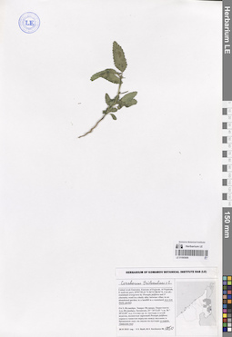
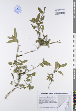
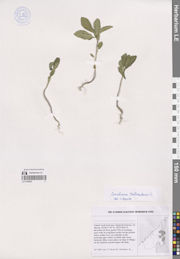
LE 01065699
Corchorus trilocularis L. det. Byalt, Vyacheslav Vyacheslavovich
Collectors: Byalt, Vyacheslav Vyacheslavovich; Korshunov, Mikhail Vladimirovich Field collecting number: 1950. Collection date: 30.11.2019. Administrative regions: AE - United Arab Emirates. Place of collection: Фуджейра. Эмират Фуджара. Окрестности г. Аль-Фуджайра, Sacamcam, сорное в сыром тенистом саду.Groups of specimens: Образцы общего сектора; Соглашение Минобрнауки №075-15-2021-1056; Бялт В.В.: Флора ФуджейрыOriginal label text: United Arab Emirates. Emirate of Fujarah. Al Fujairah, E seafront part, 25°07'55.41"N 56°21'08.54"E, 4 m alt.: weed in a wet shady garden. – ОАЭ, Фуджейра. Эмират Фуджара. Окрестности Аль-Фуджайры, Sacamcam, 25 ° 10'12.65 "с.ш. 56 ° 20'23.04" в.д., 6 м над ур. м.: сорняк в сыром тенистом саду, 30 XI 2019, fl., fr., V.V. Byalt, M.V. Korshunov 1950
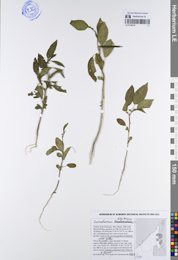
LE 01194714
Corchorus trilocularis L. det. Byalt, Vyacheslav Vyacheslavovich
Collectors: Byalt, Vyacheslav Vyacheslavovich; Korshunov, Mikhail Vladimirovich Field collecting number: 2100. Collection date: 14.04.2020. Administrative regions: AE - United Arab Emirates. Place of collection: Sharjah Emirate, Luluyah, end of Safi Esa Al Naqbi st. and gardens near Luluyah Beach [point 753]: on wasteland near gardens.Groups of specimens: Образцы общего сектора; Соглашение Минобрнауки №075-15-2021-1056; Бялт В.В.: Флора ФуджейрыOriginal label text: United Arab Emirates, Sharjah Emirate, Luluyah, end of Safi Esa Al Naqbi st. and gardens near Luluyah Beach. 25°23'24.43"N, 56°21'40.92"E, elevation 5 m. [point 753]: on wasteland withnear gardens, 14 IV 2020, fr., V.V. Byalt, M.V. Korshunov 2100
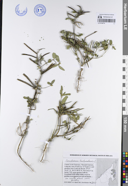
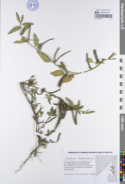
LE 01194715
Corchorus trilocularis L. det. Byalt, Vyacheslav Vyacheslavovich
Collectors: Byalt, Vyacheslav Vyacheslavovich; Korshunov, Mikhail Vladimirovich Field collecting number: 270. Collection date: 11.03.2020. Administrative regions: AE - United Arab Emirates. Place of collection: Fujairah Emirate, Al Hayl Fort (Al Hayl Castle) [point 704]: near the Fort, mountain sides, in shady place under the water tank.Groups of specimens: Образцы общего сектора; Соглашение Минобрнауки №075-15-2021-1056; Бялт В.В.: Флора ФуджейрыOriginal label text: United Arab Emirates, Fujairah Emirate, Al Hayl Fort (Al Hayl Castle). 25° 5'4.59"N, 56°13'36.84"E, elevation 240–310 m [point 704]: near the Fort, mountain sides, in shady place under the water tank, 11 III 2020, V.V. Byalt, M.V. Korshunov 270
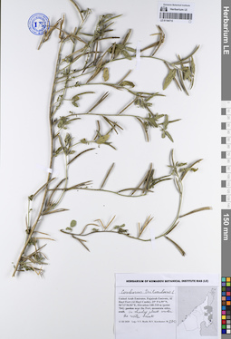
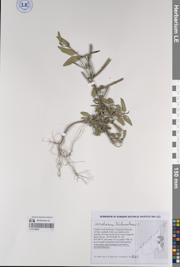
LE 01194716
Corchorus trilocularis L. det. Byalt, Vyacheslav Vyacheslavovich
Collectors: Byalt, Vyacheslav Vyacheslavovich; Korshunov, Mikhail Vladimirovich Field collecting number: 1205. Collection date: 26.03.2020. Administrative regions: AE - United Arab Emirates. Place of collection: Fujairah Emirate, vil. Sharm, villas at the coast side, on beach, in shade under tree, in sand ashore.Groups of specimens: Образцы общего сектора; Соглашение Минобрнауки №075-15-2021-1056; Бялт В.В.: Флора ФуджейрыOriginal label text: United Arab Emirates, Fujairah Emirate, vil. Sharm, villas at the coast side. 25°28'3.44"N, 56°21'41.98"E, elevation 5 m: on beach, in shade under tree, in sand ashore, 26 III 2020, fr., V.V. Byalt, M.V. Korshunov 1205
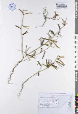
LE 01194717
Corchorus trilocularis L. det. Byalt, Vyacheslav Vyacheslavovich
Collectors: Byalt, Vyacheslav Vyacheslavovich; Korshunov, Mikhail Vladimirovich Field collecting number: 1414. Collection date: 30.03.2020. Administrative regions: AE - United Arab Emirates. Place of collection: Fujairah Emirate, village Bithna, Bithna Fort [point 725]: weed in garden close the fort wall.Groups of specimens: Образцы общего сектора; Соглашение Минобрнауки №075-15-2021-1056; Бялт В.В.: Флора ФуджейрыOriginal label text: United Arab Emirates, Fujairah Emirate, village Bithna, Bithna Fort. 25°11'13.38"N, 56°14'17.34"E, elevation 172 m. [point 725]: weed in garden close the fort wall, 30 III 2020, V.V. Byalt, M.V. Korshunov 1414
LE 01194718
Corchorus olitorius L. det. Byalt, Vyacheslav Vyacheslavovich
Additional identifications: Corchorus trilocularis L. det. Byalt, Vyacheslav Vyacheslavovich Collectors: Byalt, Vyacheslav Vyacheslavovich; Korshunov, Mikhail Vladimirovich Field collecting number: 1483/233. Collection date: 23.11.2019. Administrative regions: AE - United Arab Emirates. Place of collection: Фуджейра, горы Хаджар. Старая дорога Масафи-Дибба, сады в северо-западной окрестности пос. Аль Хала, сорное в частном саду Абдулы около ворот.Groups of specimens: Образцы общего сектора; Соглашение Минобрнауки №075-15-2021-1056; Бялт В.В.: Флора ФуджейрыOriginal label text: United Arab Emirates. Mts. Hajar. Old road Masafi-Dibba, gardens in NW environs of vil. Al Khala, 25°29'02.84"N 56°11'22"E, ca. 180 m alt.: weed in the private garden of Abdulah, near gates.– ОАЭ, Фуджейра, горы Хадж120ар. Старая дорога Масафи-Дибба, сады в сев.-зап. окр. пос. Аль Хала, 25 ° 29'02.84 "N 56 ° 11'22" E, ок. 180 м н. ур. м.: сорняк в частном саду Абдулы около ворот, 23 XI 2019 V.V. Byalt, M.V. Korshunov 1483/233
LE 01194720
Corchorus trilocularis L. det. Byalt, Vyacheslav Vyacheslavovich
Collectors: Byalt, Vyacheslav Vyacheslavovich; Korshunov, Mikhail Vladimirovich Field collecting number: 1453. Collection date: 30.03.2020. Administrative regions: AE - United Arab Emirates. Place of collection: Fujairah Emirate, near vil. Bithna. Wadi with gardens [point 724]: weed in garden in wadi bottom.Groups of specimens: Образцы общего сектора; Соглашение Минобрнауки №075-15-2021-1056; Бялт В.В.: Флора ФуджейрыOriginal label text: United Arab Emirates, Fujairah Emirate, near village Bithna. Wadi with gardens. 25°11'19.00"N, 56°14'15.97"E, elevation 170 m. [point 724]: weed in garden in wadi bottom, 30 III 2020, fl., fr., V.V. Byalt, M.V. Korshunov 1453
LE 01259093
Corchorus trilocularis L. det. Byalt, Vyacheslav Vyacheslavovich
Collectors: Byalt, Vyacheslav Vyacheslavovich; Korshunov, Mikhail Vladimirovich Field collecting number: 1661. Collection date: 01.04.2020. Administrative regions: AE - United Arab Emirates. Place of collection: Fujairah Emirate, Al Siji, roadside with car small service stations, 0.4 km North-West from Fujairah Dates Farm [point 728]: waste place and drainage from labors accommodations.Groups of specimens: Образцы общего сектора; Соглашение Минобрнауки №075-15-2021-1056; Бялт В.В.: Флора ФуджейрыOriginal label text: United Arab Emirates, Fujairah Emirate, Al Siji, roadside with car small service stations, 0.4 km North-West from Fujairah Dates Farm. 25°16'35.84"N, 56° 0'51.90"E, elevation 212 m. [point 728]: waste place and drainage from labors accommodations, 1 IV 2020, fr., V.V. Byalt, M.V. Korshunov 1661
LE 01259226
Corchorus trilocularis L. det. Byalt, Vyacheslav Vyacheslavovich
Collectors: Byalt, Vyacheslav Vyacheslavovich; Korshunov, Mikhail Vladimirovich Field collecting number: s.n. Collection date: 28.05.2020. Administrative regions: AE - United Arab Emirates. Place of collection: Fujairah Emirate, vil. Sharm [point 793]: in drainage near wall; in irrigation circles; on the garden fence; under tree; on roadside; at the sewerage pipe outlet; in shady side street between villas; waste place on edge of village; on dry bottom of pond upper the dam.Groups of specimens: Образцы общего сектора; Соглашение Минобрнауки №075-15-2021-1056; Бялт В.В.: Флора ФуджейрыOriginal label text: United Arab Emirates, Fujairah Emirate, vil. Sharm, 25°28'17.54"N, 56°21'8.03"E, elevation 10–45 m [point 793]: in drainage near wall; in irrigation circles; on the garden fence; under tree; on roadside; at the sewerage pipe outlet; in shady side street between villas; waste place on edge of village; on dry bottom of pond upper the dam, 28 V 2020, V.V. Byalt, M.V. Korshunov