View
Add
Copy
Edit
Delete

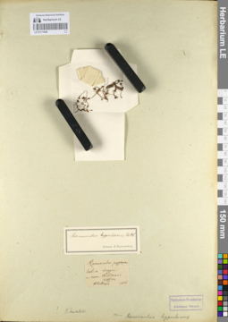
LE 01108105
Ranunculus hyperboreus Rottb. det. Knjazev, Mikhail Sergeyevich at 2018
Collectors: Melnikov, Denis Germanovich; Kuropatkin Vladislav; Lalenko Il'ya Sergeevich Field collecting number: 139. Collection date: 02.08.2018. Administrative regions: RU-Komi - Inta (gorodskoj okrug). Groups of specimens: Образцы сектора Восточной ЕвропыOriginal label text:Россия, Республика Коми, городской округ Инта, в среднем течение р. Лимбекою, правый коренной берег реки, лужа на лесной дороге.
GPS: N65° 22.991' Е60° 21.610', h= 363 м н.у.м.
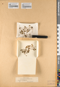
LE 01111646
Ranunculus hyperboreus Rottb. det. Ganeschin, Sergej Sergejewitsch
Additional identifications: Ranunculus pygmaeus Wahlenb. det. Meyer, Carl Anton von Collection date: 1825. Administrative regions: FI - Finland. Groups of specimens: Образцы сектора Восточной Европы; Herb. C.A. MeyerOriginal label text:in Lappon
Record creation: 2021-05-23, Flora of the Murmansk region, PhotoScan D2Citation: Specimen LE 01111646 // Virtual herbarium of Komarov Botanical Institute RAS — http://re.herbariumle.ru/01111646m: rever: Tellmann
Utsjok
LE 01226690
Ranunculus hyperboreus Rottb.
Collectors: Fellman, Nils Isak Field collecting number: 9. Collection date: 1863. Administrative regions: RU - Murmanskaya Oblast' - Lovozerskiy Rayon. Groups of specimens: Образцы сектора Восточной ЕвропыOriginal label text:Ponoj
Record creation: 2023-02-07, Denis Melnikov, PhotoScan D2.Citation: Specimen LE 01226690 // Virtual herbarium of Komarov Botanical Institute RAS — http://re.herbariumle.ru/01226690Jokonga
(Поной
Йоканьга)